
Freiimfelde / Kanenaer Weg
|
district of Halle (Saale) |
|
|---|---|
 _Stadtteil_3_09.svg) |
|
| Coordinates | 51 ° 28 '57 " N , 11 ° 59' 16" E |
| Residents | 3195 (Dec. 31, 2017) |
| Post Code | 06112 |
| prefix | 0345 |
| Transport links | |
| Federal road |
|
| tram | 4 7 10 |
| bus | 27 32 44 351 |
_001-b.jpg)
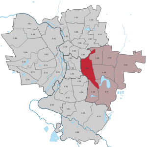
Freiimfelde / Kanenaer Weg is a district in the Halle-Ost district of Halle (Saale) in Saxony-Anhalt .
location
The district is located in the east district between the districts of Diemitz, DR, Büschdorf, Dieselstrasse and Kanena / Bruckdorf.
history
Freiimfelde called before 1815 free field, was a manor in Saalkreis of the Archbishopric of Magdeburg , under aristocratic rule and under overhead jurisdiction of the Office Giebichenstein stood. 1680 came with the Saalkreis to the Duchy of Magdeburg under Brandenburg-Prussian rule. With the Peace of Tilsit , the manor Freienfelde was incorporated into the Kingdom of Westphalia in 1807 and assigned to the Halle district in the Saale department. It belonged to the canton of Halle-Land . After Napoleon's defeat and the end of the Kingdom of Westphalia, Napoleon's allied opponents liberated the Saalkreis in early October 1813.
During the political reorganization after the Congress of Vienna in 1815, the estate was attached to the Merseburg administrative district of the Prussian province of Saxony and assigned to the Saalkreis. On November 10, 1819, the Freiimfelde manor was incorporated into the Halle a./S district.
Web links
- Halle (Saale) in figures 2017 (PDF) accessed on March 4, 2018
Individual evidence
- ^ City of Halle: Overview of the city district
- ↑ Mention of the place in the book "Geography for all Stands", pp. 127 and 130
- ^ Description of the Saale Department
- ^ The hall circle in the municipality register 1900
- ^ The urban district of Halle a./S. on www.territorial.de
.svg)
Old town | Ammendorf / Beesen | At the water tower / Thaerviertel | Böllberg / Wörmlitz | Büschdorf | Damaschkestrasse | Dautzsch | Diemitz | Diesel road | Dölau | Dölauer Heide | Freiimfelde / Kanenaer Weg | Happy future | Territory of the DR | Gesundbrunnen | Neustadt industrial park | Giebichenstein | Gottfried-Keller-Siedlung | Heide-Nord / Blumenau | Heide-Süd | North industrial area | Kanena / Bruckdorf | Kröllwitz | Landrain | Lettin | Lutherplatz / Thuringian Railway Station | Possible | Rivet life | Northern city center | Northern New Town | Paulusviertel | Planena | Radewell / Osendorf | Reideburg | Saale floodplain | Seeben | Silver height | South downtown | Southern New Town | Südstadt | Tornau | Trotha | Western New Town