
Tornau (hall)
|
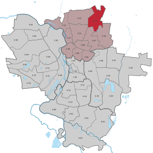
district of Halle (Saale) |
|
|---|---|
 _Stadtteil_2_32.svg) |
|
| Coordinates | 51 ° 31 '52 " N , 12 ° 0' 16" E |
| surface | 2.834 km² |
| Residents | 268 (Sep 30, 2019) |
| Population density | 95 inhabitants / km² |
| Incorporation | Jul 1, 1950 |
| Post Code | 06118 |
| prefix | 0345 |
| state | Saxony-Anhalt |
| Transport links | |
| Highway |
|
| bus | 25th |
Tornau is a district with 268 inhabitants (2019) in the northern district of Halle (Saale) in Saxony-Anhalt .
geography
location

Tornau is in the north of the city on the border with the Saalekreis . Neighboring districts are Seeben in the west, Frohe Zukunft and Gottfried-Keller-Siedlung in the south and Mötzig in the southeast. Tornau on the north-eastern edge of the city of Halle is still very rural. It consists of a village center surrounded by grassland and arable land.
The Posthornteich is located south of Tornau . This continues to the east into a swampy area with smaller ponds. The cycle path from Halle to Petersberg runs west of Tornau . On this stands the prehistoric menhir Franzosenstein . There is also a large radio tower west of Tornau.
traffic
Tornau is on the old country road from Halle to Dessau . It is still connected to places like Oppin as a result. There are other road connections to the Merry Future and to Seeben and Mötzig. In the north is the Halle-Tornau exit of federal motorway 14 . Large cities such as Leipzig and Magdeburg can be reached via these . Bundesstraße 100 runs a few kilometers south of Tornau .
There are only a few local public transport systems in Tornau. The bus line 25 of the Halleschen Verkehrs AG ends in town. There is also an OBS stop with a connection to Halle and the north-eastern Saalekreis and to Zörbig .
history
Tornau belonged to the Giebichenstein office in the hall circle of the Archbishopric of Magdeburg . In 1680 the place came with the Saalkreis to the Duchy of Magdeburg under Brandenburg-Prussian rule. With the Peace of Tilsit in 1807, Tornau was incorporated into the Kingdom of Westphalia and assigned to the Halle district in the Saale department. The place belonged to the canton of Neumarkt . After Napoleon's defeat and the end of the Kingdom of Westphalia, Napoleon's allied opponents liberated the Saalkreis in early October 1813. During the political reorganization after the Congress of Vienna in 1815, the place was attached to the administrative district of Merseburg in the Prussian province of Saxony and assigned to the Saalkreis.
On July 1, 1950, Tornau was incorporated into Halle (Saale).
In 2019, the city administration of Halle discussed their idea of a so-called north bypass with the citizens. This new road is to lead from the new crossing of the Osttangente ( Europachaussee ) with the federal highway 100 to the north past Mötzig and Tornau. From there, the road should make a curve to the west and lead past Seeben to the Saale harbor in Halle-Trotha . Together with the north bypass, a new industrial area is to be built northwest of Tornau, as the Star Park industrial area barely has any free space a few kilometers southeast. Local residents protested against the proposal. After an examination by the city, at least the idea of the industrial park was put aside for the time being because of the high costs.
Web links
- https://halle.de/ - The Tornau district on the website of the city of Halle (Saale).
- Mitteldeutsche Zeitung, 4th July 2017, district series: Tornau
Individual evidence
- ↑ a b Halle route network and tariff zone plan , accessed on December 29, 2017.
- ↑ Statistical quarterly report 03/2019 Halle (Saale), December 04, 2019
- ↑ a b c State Office for Surveying and Geoinformation Saxony-Anhalt: Saxony-Anhalt Viewer . Can be found online at: https://lvermgeo.sachsen-anhalt.de/ , accessed on: November 23, 2019.
- ↑ Mitteldeutscher Verkehrsverbund: Route network plan, from August 15, 2019. Available online at https://mdv.de/ ( pdf ). Accessed November 23, 2019.
- ↑ Mention of the place in the book "Geography for All Stands", p. 126
- ^ Description of the Saale Department
- ^ The hall circle in the municipality register 1900
- ↑ Halle (Saale) and its districts on gov.genealogy.net
- ↑ Enrico Seppelt: Planning for the north bypass should begin in early 2019 . Published online at https://dubisthalle.de/ on October 23, 2018.
- ↑ Enrico Seppelt: Tornau industrial area closed - development would cost 100 million euros . Published online at https://dubisthalle.de/ on June 11, 2019.
.svg)
Old town | Ammendorf / Beesen | At the water tower / Thaerviertel | Böllberg / Wörmlitz | Büschdorf | Damaschkestrasse | Dautzsch | Diemitz | Diesel road | Dölau | Dölauer Heide | Freiimfelde / Kanenaer Weg | Happy future | Territory of the DR | Gesundbrunnen | Neustadt industrial park | Giebichenstein | Gottfried-Keller-Siedlung | Heide-Nord / Blumenau | Heide-Süd | North industrial area | Kanena / Bruckdorf | Kröllwitz | Landrain | Lettin | Lutherplatz / Thuringian Railway Station | Possible | Rivet life | Northern city center | Northern New Town | Paulusviertel | Planena | Radewell / Osendorf | Reideburg | Saale floodplain | Seeben | Silver height | South downtown | Southern New Town | Südstadt | Tornau | Trotha | Western New Town