
Dölauer Heide
|
forest district of Halle (Saale) |
|
|---|---|
 _Stadtteil_5_94.svg) |
|
| Coordinates | 51 ° 30 '0 " N , 11 ° 53' 35" E |
| surface | 7.59 km² |
| Residents | 12 (Dec. 31, 2016) |
| Population density | 2 inhabitants / km² |
| Post Code | 06120 |
| prefix | 0345 |
| country | Saxony-Anhalt |
The Dölauer Heide is a forest area on the western edge of Halle (Saale) and at the same time a part of the city district West . With an area of 740 hectares, it is the largest protected landscape area in the area.
geography
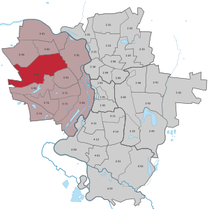
The heather protrudes like a wedge into the area of the city and is largely bounded by Halle districts: Dölau , Heide-Nord and Lettin in the north, Kröllwitz in the east, Heide-Süd in the southeast, Halle-Neustadt and Nietleben in the south; west of the heather is the village of Lieskau ( Saalekreis ).
The heather is predominantly a mixed forest, but there are also a few areas with monocultures, v. a. Pine trees ; these are residues of afforestation at the end of the 19th century. The area is crossed by a plateau ridge that rises around 20 meters above the surrounding area. Numerous ravines caused by erosion are also typical. The highest peaks are the 133 meter high Kolkturmberg, also called Bischofsberg, and the Kellerberg with a height of 130 meters. The waters in the heather are the Herthateich and the Rehteich, which were created on lens-like deposits of clays in the ground and temporarily carry water.
use
The heather trees have been used by the Hallors as fuel for salt production since the Middle Ages . From 1840 the western part of the forest was a mining area and lignite was mined for several decades . The urban forest still serves as a commercial forest and is FSC certified.
In the middle of the 19th century, when the heath belonged to the Prussian state , the heather cemetery was laid out. It was used to bury nameless people, mainly suicides and victims of violent crimes who died in the heath. In 1929 the Dölauer Heide became the property of the city of Halle and the cemetery lost its function.
Since the 19th century, the heathland has enjoyed great importance as a recreational area due to its location close to the city. Popular excursion destinations are the Heidesee , a remaining open pit on the southern edge between Heide and Nietleben, the Kolkturm on the Kolkturmberg and several restaurants. Riding paths and a nature trail run through the heather, and there is a designated toboggan run in winter. Until the closure of the Nietleben-Dölau section of the route in 2002, the Heide could be reached by S-Bahn , the central stop was the Heidebahnhof.
On November 10, 1979, a Heidelauf was held for the first time as a running event in the Dölauer Heide. Since 1988 there has been an annual blue run series that consists of up to eight runs and has seen increasing numbers of participants for years. In 2018, an average of 580 runners and Nordic walkers were counted in the Heidelauf series, making the Heidelauf series central Germany's most popular running cup.
Since April 2013 there have been ten wooden sculptures in the forest, which were erected there as part of the project Trees Experience History - Trees Tell History .
Archaeological evidence

The plateaus of the Bischofswiese and the Lange Berg were settled in the Neolithic Age and were the site of prehistoric fortifications of the Baalberg culture (4100–3600 BC) and the Bernburg culture (3300–2800 BC). The oldest evidence of salt production in Central Germany also comes from a plant belonging to the Bernburg culture. During the following Corded Ware Culture (2800-2200 v. Chr.) Were at least 36 on the eastern edge of the ancient fortifications and further to the southwest on the Tonberg and the Black Mountain grave mounds with stone boxes and cairn tombs (internals in the grave hill 28 ), whose objective partly in the Early Bronze Age (2200–1600 BC) were used for subsequent burials . A further small stone box , which was discovered on Waldkaterallee that could Beaker culture are assigned (2500-2200 v. Chr.). Another fortification comes from the early modern era : the Schwedenschanze . It was built during the Thirty Years' War in 1636 and served as an observation post for the Swedish army when they tried to recapture the city of Halle.
literature
General
- Local history museum of the city of Halle (ed.): The Dölauer Heide. Halle (Saale) 1973.
- Kreiskommission Natur- und Heimatfreunde Halle (Ed.): The Dölauer Heide - A handbook for the friends of the Halle city forest and for the youth. Self-published, Halle 1953
- Magistrate of the city of Halle (ed.): The Dölauer Heide - forest idyll close to the big city. Contributions to geography, flora and fauna, history as well as hazards, protection and maintenance measures of the Halle city forest. Nexö, Leipzig 1993.
- Hans Joachim Schramm : Legends of the Dölauer Heide. Old stories and stories from Halle's urban forest. Freedom, Halle (Saale) 1987.
- Kurt Wünsch: Heidepinzessin and rowanberry tree: an educational walk through the Dölauer Heide. Mitteldeutscher Verlag, Halle (Saale) 2011, ISBN 9783898128018 .
archeology
- Hellmut Agde: Landscape of the Stone Age in Central Germany. Gebauer-Schwetschke, Halle 1935.
- Hellmut Agde: Corded ceramic tumuli of the Hallescher Heide. Investigation of tumulus III. In: News sheet for German prehistoric times. Volume 11, 1935, pp. 126-127.
- Hermann Behrens : A new Central German grave with wall decorations. In: excavations and finds. Volume 1, 1956, pp. 217-221.
- Hermann Behrens: A Neolithic burial mound with a multilayer structure in the Dölauer Heide near Halle (Saale). In: Annual publication for Central German prehistory. Volume 41/42, 1958, pp. 213-242.
- Hermann Behrens, Paul Faßhauer, Horst Kirchner: A new interior decorated stone chamber grave made of corded ceramics from the Dölauer Heide near Halle (Saale). In: Annual publication for Central German prehistory. Volume 40, pp. 13-50.
- Hermann Behrens, Brigitte Rüster: Calibrated C14 data for the Neolithic of the Middle Elbe-Saale area. In: Archaeological correspondence sheet. Volume 11, 1981, pp. 189-193.
- Hermann Behrens, Erhard Schröter: Settlements and graves of the funnel cup culture and cord ceramics near Halle (Saale). Results of excavations (= publications of the State Museum for Prehistory. Volume 34). German Science Publishing House, Berlin 1980.
- Ulrich Fischer : The Stone Age graves in the Saale region. Studies on Neolithic and Early Bronze Age grave and burial forms in Saxony-Thuringia . Verlag Walter de Gruyter & Co., Berlin 1956, ISBN 978-3-11-005286-2 .
- Dieter Kaufmann: A look into history. In: Magistrat der Stadt Halle (Hrsg.): The Dölauer Heide - forest idyll near the big city. Contributions to geography, flora and fauna, history as well as hazards, protection and maintenance measures of the Halle city forest. Nexö, Leipzig 1993, pp. 85-93.
- Dieter Kaufmann, Arno Brömme: A grave complex of the Baalberger group in the Dölauer Heide near Halle (Saale). In: Annual publication for Central German prehistory. Volume 56, 1972, pp. 39-57.
- Waldemar Matthias: Catalogs on Central German Corded Ceramics V. Middle Saale Region (= publications of the State Museum for Prehistory. Volume 35). German Science Publishers, Berlin 1982.
- Detlef W. Müller: Big stones, old characters. Neolithic imagery in grave customs and religion. In: Archeology in Saxony-Anhalt. Volume 1, 1991, pp. 20-26.
- Detlef W. Müller: The Bernburg culture of Central Germany in the mirror of its non-megalithic collective graves. In: Annual publication for Central German prehistory. Volume 76, 1994, pp. 75-200.
- Joachim Preuß: On the stratigraphy of Neolithic burial mounds of the Saale area. In: Annual publication for Central German prehistory. Volume 60, 1976, pp. 197-199.
- Mario Schmidt: A Neolithic burial landscape: The Dölauer Heide as a sepulchral room. In: Hans-Jürgen Beier (Ed.): Finding and Understanding. Festschrift for Thomas Weber on the occasion of his sixtieth birthday (= contributions to the prehistory and early history of Central Europe. Volume 66). Langenweißbach 2012, ISBN 978-3-941171-67-1 , pp. 135-144.
- Waldtraut Schrickel : Western European elements in the Neolithic and the Early Bronze Age of Central Germany. Part I. Catalog (= publications of the State Museum for Prehistory Dresden. Volume 5). VEB Bibliographisches Institut, Leipzig 1957.
- Erhard Schröter: A new stone box grave in the Dölauer Heide near Halle. In: excavations and finds. Volume 22, 1977, pp. 200-202.
- Erhard Schröter: Dölauer Heide. In: Joachim Herrmann (Hrsg.): Archeology in the German Democratic Republic. Monuments and finds. Volume 2. Urania Verlag, Leipzig / Jena / Berlin 1989, ISBN 3-8062-0531-0 , pp. 419-422.
- Torsten Schunke: Archaeological find chronicle of the state of Saxony-Anhalt 1998. Halle-Dölauer Heide. In: Annual journal for Central German Prehistory. Volume 82, 1999, pp. 297-299 ( online ).
- Torsten Schunke: The fortified settlement Bischofswiese, Halle-Dölauer Heide. In: Harald Meller (ed.): 3300 BC - mysterious stone age dead and their world. Nünnerich-Asmus, Mainz 2013, ISBN 978-3-943904-33-8 , pp. 139–142 ( online ).
- Torsten Schunke: Flood of images in the dark - burial mound 6 in the Dölauer Heide and the stone chamber decorated inside. Nünnerich-Asmus, Mainz 2013, ISBN 978-3-943904-33-8 , pp. 143-150 ( online ).
- Bodo Wemhöner, Ralf Schwarz: Halle and the Saalekreis. In: Routes of archeology. Volume 1, State Office for Monument Preservation and Archeology Saxony-Anhalt - State Museum for Prehistory, Halle (Saale) 2006, ISBN 3-910010-97-X , pp. 84–105, 123–126.
Web links
- Siegmar von Schultze-Galléra : The heath - the Halle city forest
- Halle (Saale) in figures 2016 (PDF) accessed on December 30, 2017
- The stone boxes in the Dölauer Heide on Grosssteingraeber.de
Individual evidence
- ^ City of Halle: overview of city districts
- ^ Klaus Friedrich , Manfred Frühauf : Halle and its surrounding area . Geographic excursion guide. mdv Mitteldeutscher Verlag, Halle (Saale) 2002, ISBN 3-89812-167-4 .
- ↑ www.heidelaufserie.de: [1] , accessed on March 6, 2012.
- ↑ mz-web.de
- ↑ Bodo Wemhöner, Ralf Schwarz: Halle and the Saalekreis. 2006, pp. 86-104.
.svg)
Old town | Ammendorf / Beesen | At the water tower / Thaerviertel | Böllberg / Wörmlitz | Büschdorf | Damaschkestrasse | Dautzsch | Diemitz | Diesel road | Dölau | Dölauer Heide | Freiimfelde / Kanenaer Weg | Happy future | Territory of the DR | Gesundbrunnen | Neustadt industrial park | Giebichenstein | Gottfried-Keller-Siedlung | Heide-Nord / Blumenau | Heide-Süd | North industrial area | Kanena / Bruckdorf | Kröllwitz | Landrain | Lettin | Lutherplatz / Thuringian Railway Station | Possible | Rivet life | Northern city center | Northern New Town | Paulusviertel | Planena | Radewell / Osendorf | Reideburg | Saale floodplain | Seeben | Silver height | South downtown | Southern New Town | Südstadt | Tornau | Trotha | Western New Town