Petersberg (near Halle)
| Petersberg | ||
|---|---|---|
|
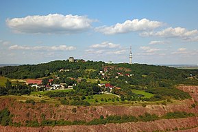
The Petersberg from the direction of Löbejün |
||
| height | 250.4 m above sea level NHN | |
| location | in Petersberg (near Halle ), Saalekreis , Saxony-Anhalt ( Germany ) | |
| Coordinates | 51 ° 35 '48 " N , 11 ° 57' 11" E | |
|
|
||
| rock | Rhyolite | |
| particularities |
Mining lakes Goethe break , Krosigker break , Kloster Petersberg , Bismarckturm Petersberg , telecommunications tower Petersberg , telecommunications skyscraper, zoo Petersberg |
|
The Petersberg near Halle an der Saale in the municipality of Petersberg is 250.4 m above sea level. NHN the highest point in the former Saalkreis in Saxony-Anhalt .
Its name is derived from the St. Peter's Church on the mountain. The Petersberg was known as Lauterberg until the 14th century .
geography
location
The Petersberg is about 13 km (as the crow flies ) north of downtown Halle an der Saale , not quite halfway to Köthen between the villages of Ostrau and Wallwitz . On the mountain is the municipality of Petersberg with the eponymous core town and its districts Drehlitz and Frößnitz . The Saale tributary Götsche flows a little southwest past the mountain , and to the north the landscape drops into the valley of the Saale tributary Fuhne .
Natural allocation
According to the handbook of the natural spatial structure of Germany, the Petersberg lies within the natural spatial main unit group Central German Black Earth Area (No. 50) in the main unit Eastern Harz foreland (500).
In the Saxony-Anhalt division into landscape areas , it is located in the unit of Hallesches arable land .
Mountain height
The Petersberg is 250.4 m high. About 130 m southeast of its summit is a trigonometric point at a height of 247.8 m . Contrary to popular belief, the mountain is not the highest point between the Harz and Ural Mountains at its latitude . For example, in Górki Duże near Tuszyn in Poland there is a 283 m ( ⊙ ) high elevation of the Piotrkowska Heights. In Russia there is a 267 m ( ⊙ ) high elevation of the Central Russian Plate in the Kursk Oblast near Kirovka ( Кировка ) and a 306 m ( ⊙ ) high elevation of the Volga plate in the Saratov Oblast near Vyazovka ( Вязовка ) .
geology

The Petersberg is the highest elevation of the Halle porphyry complex . The rock it is made of is known as rhyolite . This rock, like that of the other porphyry peaks in the area, was formed in the time of the Upper Carboniferous and Lower Permian through the solidification of viscous magma relatively close to the ground ( cryptovolcanism ). The relatively large feldspar and quartz crystals (so-called sprinkles ), which are easily visible to the naked eye in the rock , formed at a greater depth in a magma chamber when the melt cooled down very slowly. After its ascent to shallower depths, the magma then cooled much faster, which finally resulted in a rock with a very fine crystalline base mass in which the larger quartz and feldspar crystals are embedded ( porphyry structure ). In comparison to other rhyolites in the Halle area, however, the inserts of the Petersberg rhyolite are relatively small. One therefore speaks of a fine porphyry rhyolite .
Today's mountain with its relatively hard rhyolite rock has been carved out of the sedimentary rock that originally covered it through erosion , among other things by the glaciers of the last ice ages .
The rhyolite of the Petersberg is used as natural stone . The neglectful, partially water-filled Goethebruch on the upper south-western slope of the mountain testifies to the historical mining. The quarry is currently being excavated in a large quarry at the foot of the southwest slope.
Protected areas
On and around the Petersberg in 1998 reported and 21.83 square kilometers is the conservation area Petersberg ( CDDA -No. 20851). Around the mountain are the nature reserves Bergholz (CDDA no. 162383; 1961, 0.77 km²; two-part) and Blonsberg (CDDA no. 318206; 1998, 0.3 km²) and also the fauna and flora habitat - Areas of Bergholz north of Halle (FFH no. 4437-305; 1.81 km²) and Blonsberg north of Halle (FFH no. 4437-301; 0.32 km²).
Petersberg Monastery
The Petersberg Monastery with the St. Petrus Collegiate Church is a former Augustinian canon monastery. An Evangelical monastery community of the Christ Brotherhood Selbitz has existed since 1999 .
Bismarck Tower
One of the 15 remaining Bismarck towers in Saxony-Anhalt is on the Petersberg . The 15 m high Bismarck tower on the Petersberg was built according to a design by Wilhelm Kreis and inaugurated on September 24, 1902. In the Second World War was heavily damaged lookout tower extensively renovated 1999/2000, he then that for the first time since the war again was climbable.
Petersberg telecommunications tower
About 320 meters southeast of the Petersberg summit stands the 119 m high Petersberg telecommunications tower of Deutsche Telekom , which was inaugurated in 1965 and was built using reinforced concrete. Several radio programs for the greater Halle area are broadcast from there, including MDR Sachsen-Anhalt , MDR Sputnik and Radio SAW .
Telecommunication tower

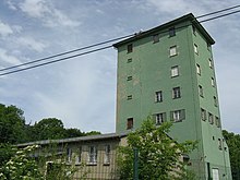
There is also a seven-story A-tower of Deutsche Telekom AG on the Petersberg . Before the political change in the GDR , this tower belonged to the basic funds of the SED party . In it was the district radio control center Halle (Saale) of the directional radio network of the party (its code name: 08A1) as well as directional radio and switching technology of the NVA. The building, also known as the A tower , was erected at the end of the 1950s as part of the first expansion stage (network level 1). With network level 1, all district leaderships were connected to the party's central committee in Berlin. In a second network level, up to around 1973, the network was expanded to include all district leaderships of the party. Extensive structural and technical investments by the NVA in the building and network of the party led to the joint use of the party's facilities by the NVA. The territorial military organs, offices, associations, military districts, commandos of the armed forces and the Ministry of National Defense of the NVA, as well as the district operations command in the event of war, became participants in these networks via the radio link. In 1984 the nets were handed over to the Deutsche Post (GDR) and with it the tower. Up until the shutdown in 1989/90, the NVA used a large number of directional radio channels for a fee as part of a prepared system of communication links in the event of war. After 1990 the tower went to Deutsche Telekom . The technical equipment was removed and the antenna supports with the antennas on the roof were dismantled.
Transport links
4.3 km southwest of the Petersberg, the state road 50 (former B 6 ) crosses the federal motorway 14 at the Halle-Trotha junction . A narrow road branches off from the L 50 to the northwest of the junction and runs northeast through Sylbitz to Trebitz . From there, Kreisstraße 2119 (Alte Hallesche Straße) , which crosses the L 145 (Köthener Landstraße ) , which connects Frößnitz and Kaltenmark, and runs through Petersberg, ultimately eastwards to the elevation. A spur road branches off from the K 2119 in Petersberg, which leads north-west to its high elevations.
tourism
The Petersberg is a popular destination. On the mountain is the Petersberg zoo with Eurasian animals and a summer toboggan run , which can be used all year round with a sledge or sledge- like vehicles. Flea markets and other events take place regularly on a festival site on the mountain , for example an exhibition every year at Easter . The European long-distance hiking trail E11 ( Netherlands - Masuria ) runs over the eastern mountain elevations . The climbing area Petersberger Steinbrüche consists of the Goethebruch and the Krosigker Bruch.
Individual evidence
- ↑ a b c d e Map services of the Federal Agency for Nature Conservation ( information )
- ^ Emil Meynen , Josef Schmithüsen (Ed.): Handbook of the natural spatial structure of Germany . Federal Institute for Regional Studies, Remagen / Bad Godesberg 1953–1962 (9 deliveries in 8 books, updated map 1: 1,000,000 with main units 1960).
- ↑ The Landscape Structure of Saxony-Anhalt (as of January 1, 2001) - Ministry for Regional Planning, Agriculture and Environment and State Office for Environmental Protection Saxony-Anhalt (PDF; 2.6 MB)
- ↑ The Great Falk Atlas - Europe Travel Maps , M = 1: 750,000, 2004/2005, ISBN 3-8279-0381-5
- ↑ a b Soviet General Staff Map on topomapper.com
- ↑ Bismarckturm Halle / Saale on www.bismarcktuerme.de
- ↑ Goethebruch - Petersberg quarries , at the DAV , on alpenverein.de
Web links
- The directional radio network of the party (SED) ud NVA (with a link to the "Fernmeldehochhaus" on the Petersberg in the 1970s)
literature
- Otfried Wagenbreth and Walter Steiner: Geological Forays: Landscape and Geological History between Cape Arkona and Fichtelberg . Spektrum Akademischer Verlag, 4th edition Leipzig 1990, ISBN 3-342-00227-1 .
- Peter Rothe: The geology of Germany: 48 landscapes in portrait . 2nd edition, Wissenschaftliche Buchgesellschaft, Darmstadt 2006, ISBN 3-89678-586-9 .
- Hans-Werner Deim, Hans-Georg Kampe, Joachim Kampe, Wolfgang Schubert: The military security of the GDR in the Cold War . Meißler, Hönow 2008, ISBN 978-3-932566-80-6 .


