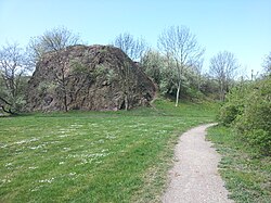
Hallescher porphyry complex

The Hallesche Porphyry Complex (also Hallescher Vulkanitkomplex, Halle-Vulkanitkomplex, Hallescher Paläovulkanitkomplex or Hallescher Eruptivekomplex) is a rock complex characterized by permocarbone intermediate and above all acidic volcanic rocks (" porphyry ") within the urban area of Halle ( north-east Saale) and in the north-east of the city and eastern outskirts of the city.
Regional geology
The Halle porphyry complex is located in the northeast part of the Saale Valley , a Rotliegendbeckens that at the end of the Carboniferous in the Variscan folded crust einsenkte of today's Central Germany. The filling of the northeastern part of the Saale Depression and with it the volcanic rocks of the Hallesches porphyry complex, which extend over an area of about 500 km², are largely covered by thin Cenozoic sediments. The Hallesche Porphyry Complex is bounded in the northeast by the Köthen-Bitterfeld fault zone and in the southwest by the Halle fault (also Hallesche Marktplatz fault , because it runs below the city's historic market square). The Halle Fault, which today, after being reactivated by the Alps, separates the Halle-Wittenberger Scholle from the Merseburger Scholle (north-eastern Thuringian Basin ), could have played an important role as an ascent path for the magmas of the Halle porphyry complex. To the southwest of the Halle Fault, the Rotliegend of the Saale Valley continues below the Triassic and Upper Permian ( Zechstein ) sedimentary rocks of the Thuringian Basin to roughly the Thuringian Forest .
Age
The earliest evidence of volcanic activity come from the Stephanian C . However, the main part of magma production falls in the Lower Red lying area , represented by sub-volcanic intrusions up to 1000 m thick . Radiometric dating revealed absolute rock ages between 301 and 294 mya for these intrusion bodies .
rocks
The predominant part of the Hallesches porphyry complex consists of rhyolites in porphyry form ("quartz porphyry"). A significantly lower volume is accounted for by basic to intermediate volcanic rocks ("porphyrites": trachybasalts , trachyandesites and trachydacites ), which occur mainly in the north and south-east of the complex and are sometimes only known from boreholes.
structure
The Hallesche Porphyry Complex is traditionally structured as follows:
-
Upper Hallescher Rhyolite (Upper Hallescher Porphyry, fine porphyry)
- Wettin rhyolite
- Petersberg rhyolite
-
Lower Hallescher Rhyolite (Lower Hallerscher Porphyry, large porphyry)
- Löbejüner rhyolite
- Landsberger rhyolite
- Hallescher rhyolite in the narrow sense
The complex Schwerzer rhyolite occupies a special position.
Effects on the landscape
Since the Halle-Wittenberger floe was pushed up against the adjoining Merseburger floe to the south in the course of the long-range effect of the formation of the Alps at the Halle fault, and thus raised, there was erosion of the previous surface layers of the Triassic, Zechstein and the younger Rotliegend, the southwest of the hall -Fault persisted. The volcanites of the Hallesches Porphyry Complex, which are significantly more resistant to erosion than these cover layers, were cut out of the subsoil, creating the region's typical domed relief.
This "porphyry hill landscape" includes u. a. the Giebichenstein with its castle and the Galgenberg in Halle (134.2 m), the Lunzberge (Lunzberg: approx. 108 m) northwest of Halle on the left of the Saale and, not far from the Lunzberge on the right bank of the Saale, the Brachwitz Alps and the 250, 4 m high Petersberg north of Halle and the Kapellenberg (148 m) in Landsberg (Saalekreis) east of Halle. The Haltberg (approx. 186 m) and the Wettiner Berg (approx. 175 m) near Löbejün, approx. 10 km north of Halle, are also formed by rhyolite. There is a large quarry on the Wettiner Berg, in which the Löbejun porphyry (Löbejun rhyolite) is extracted as a building block. Rhyolite that is open and exposed to the weather for long periods of time often has a characteristic black patina .
swell
- Dietrich Franke: Regional Geology East. Geological online reference work for East Germany with around 2500-page encyclopedia (PDF; 19 MB) and separately downloadable maps and tables, including a map of the magmatite deposits (late Variscan granitoids and Rotliegend volcanic rocks) of the Halle-Wittenberg floe (PDF; 532 kB) .
- Hallescher Porphyry Complex. Entry in the online geographic glossary of the Martin Luther University Halle-Wittenberg.
- Brachwitz Switzerland. on geocaching.com: Popular geological and local history information page about the "Brachwitz Alps" with photos.
References and comments
- ↑ The Rotliegend in the south-eastern part of the Thuringian Forest was formerly also considered part of the filling of the Saale Valley, but is now assigned to its own subsidence structure, the Thuringian Forest Basin.
- ↑ C. Breitkreutz, M. Geißler, A. Mock, B.-C. Ehling: Sedimentation and volcanism in the eastern part of the Saale basin at the turn of the Karbon-Permian: Status of work in the Halle volcanic complex. In: Upper Carboniferous - Lower Triassic in Central Europe: Processes and their timing. Workshop on the Freiberg "GeoTagen 2002". TU Bergakademie Freiberg, Geological Institute, 22. – 23. June 2002, pp. 7-9. ( PDF on geo.tu-freiberg.de; 3.3 MB)
- ↑ For detailed considerations on this unit see Mark Exner, Max Schwab: The Wettin Rhyolite - Contribution to Surface Spreading and Formation of a Hallesches Quartz Porphyry. Hercynia, new episode. Vol. 33, 2000, pp. 173–190 ( PDF on zobodat.at; 8.9 MB)
- ↑ Height of the mountains (above sea level) given in or estimated according to TK 1: 10,000 in the Saxony-Anhalt Viewer of the State Office for Surveying and Geoinformation ( notes )


