
Federal road

The following are designated as federal highways:
- In Germany, trunk roads (overland roads) owned by the federal government, which primarily serve national traffic . In contrast to the autobahn , federal highways (provided they are not signposted as motorways ) are not used exclusively for high-speed motor vehicle traffic .
- In Austria :
- historically, the national highways under federal administration. The road type no longer exists, the roads previously known as “ Bundesstraße ” are now called “ Road with priority ”, and the “B” marking has been retained.
- today roads in general, the maintenance of which is incumbent on the federal government ("federal roads"), ie mostly roads of paramount importance for national traffic.
Countries with federal highways
Most of the federally organized states have a network of federal highways. In some countries these are called differently, for example as national roads .
Germany

In 2019, the total length of the federal highways was almost 38,000 km. Federal roads can be expanded with two, three (e.g. B 27 between Hünfeld and Fulda ), four or six lanes ( Rhine bridge Maxau on the B 10 between Wörth am Rhein and Karlsruhe) with separate lanes depending on the traffic volume . The latter then have a motorway-like appearance. Together with the autobahns, state roads and district roads , the federal highways form the superordinate road network, as it is defined in the state of Berlin , for example .
properties
The abbreviation consists of a consecutive number and the preceding capital letter "B" (for example B 35 ). The road traffic is marked in accordance with the road traffic regulations by means of small, black-framed, yellow boards with the number in black letters. Until the amendment of the road traffic regulations in 1970, this sign meant a priority road as a traffic sign . The mileage is done with small signs at the roadside, which are called station signs in Germany .
In the GDR the appropriate roads were highways called and were marked with an "F". The numbering of national, long-distance and federal highways was retained, only individual roads were downgraded (for example, those that were supplemented by parallel motorways). The names in the former Reich territory, which no longer belongs to Germany, are no longer valid; after 1945 they were replaced by the local administrations with different names.
The usual speed limits for motorized vehicles on federal highways are, unless explicitly stated otherwise:
- outside built-up areas km 100 / h
- 50 km / h within built-up areas
- On federal roads similar to autobahns (with at least two lanes for one direction of travel or if the directional lanes are structurally separated), a recommended speed of 130 km / h applies in Germany . (a " yellow highway ")
The road construction load lies with the Federal Republic of Germany, which, however, transfers the order management to the individual federal states. This means that the road construction administration of each federal state is responsible for the construction and operation of the federal roads in its administrative area. When passing through towns on federal highways in the area of cities with more than 80,000 inhabitants, the construction load lies with the municipality. In cities with between 50,000 and 80,000 inhabitants, the building load can be transferred to the respective municipality at the request of the municipality with the approval of the highest municipal supervisory authority ( § 5 FStrG ).
In Germany, the federal road network covers around 40,700 kilometers.
Systematics and history


Towards the end of the Weimar Republic , in view of the gradual increase in motorization and the associated new construction and expansion of several highways, the planning of a uniform numbering of highways in Germany was tackled. In more motorized countries such as France or the USA , such numbering was already implemented at this point in time.
On May 10, 1926, the Reichstag commissioned the government to develop “a uniform network of important country roads”. At this meeting he accepted a motion for a resolution put forward by the SPD deputy Georg Simon , which the transport committee had developed on the occasion of the discussion about an impending increase in vehicle tax: “In view of the fact that the importance of roads and paths for through traffic of Motor vehicles are constantly growing, recognizing the need to expand and manage the road network in the Reich according to uniform major criteria, if the economy as a whole is not to suffer severe damage in the long term, [if necessary] the road and path construction law within the scope of the Reich constitution “To regulate. As a result of this impetus, the Reichsamt für Landesaufnahme issued a map of long-distance roads (with a red network of long-distance roads) in 1930 by the Reichsamt für Landesaufnahme according to the specifications of the Reich Ministry of Transport, and on January 17, 1932, the new system of long-distance roads with the abbreviation F was introduced to "improve orientation in the German Reich" . In view of the federal distribution of tasks in the Weimar Constitution , in which the roads belonged to the states and not to the Reich, the new network was limited to marking routes for long-distance traffic. The first nine numbers - the single-digit numbers - were assigned to the streets that ran through Germany. They formed the basic network . The two- and three-digit numbers were systematically assigned from south to north and further from west to east. With the number 138, this first phase of numbering was completed. Since the last of these numbered streets were all in the east of the former German Empire ( Silesia , Pomerania , eastern Brandenburg as well as Neumark and East Prussia ) and these eastern areas fell to Poland and the Soviet Union after the Second World War , there is a gap in the current system of federal highways from numbers 114 to 165 (in a shortened form, however, roads 115 , 156 and 158 are still represented in Brandenburg, Saxony and Mecklenburg-Western Pomerania). The road with the number 122 (after 1945 called F 122 and later B 122) was part of it, until it was rededicated and a new federal road 122 (B 122) was designated in the north of Brandenburg and in the south of Mecklenburg.
With the "Law on the Temporary New Regulation of Roads and Road Administration" of March 26, 1934, the long-distance roads that were taken over were renamed as Reichsstraßen and the new road traffic regulations introduced the small yellow sign with the street number that is still common today. Reichsstraßen were marked with an "R" and a number. Country roads of the first order and country roads of the second order were introduced as further order classes. In a first phase, the previous trunk roads and the newly added imperial roads were led with their previous names. An example can be found in an official district description of the Prussian, today Rhineland-Palatinate district of Ahrweiler , in which the imperial and today's federal highways 9, 257, 266, 267 and 258 are described as follows:
“The district is accessible through the following streets:
A. Reichsstraßen
- Street F 9 Cologne-Mainz (Rheinstrasse).
- Street No. 312 Bonn-Trier via the so-called Grafschaft.
- Street No. 310 Euskirchen-Linz via the so-called Grafschaft to the Ahr.
- Street No. 322 Bad Neuenahr-Altenahr.
- Street No. 313 Aachen-Nürburgring-Mayen-Koblenz.
B. 1st order streets (provincial streets)
[...] (followed by 13 streets with three-digit numbers beginning with 5, 8 or 9)
C. Second order streets (district streets)
with a total length of 182.973 km. [...] "
The second phase of the numbering began in 1936 after a decree of the General Inspector for German Roads of February 27, 1936 ordered the numbering of all Reichsstraßen, and was based on the numbering of trunk roads, which was also changed in some places. The new numbers continued from 139 in East Prussia and migrated in the opposite direction to the west and then again from north to south. Numbers issued in this phase were the 139 to 327. The numbers 328 to 432 were issued from 1938 to the end of the war , and exclusively for those before the war ( annexation of Austria and annexation of the Sudetenland and occupation of the so-called “ rest of Czechia” “) And during the war (in Poland , France , Luxembourg and Belgium ) annexed or under German civil administration areas as well as important connecting routes there. Many of these numbers from 328 to 432 no longer exist or have been reassigned. Some numbers like the 400 have even been rededicated several times over the years. Short sections of the B 378 and B 399 still exist to this day , while the B 388 was considerably extended to the west.

After the Second World War, the numbering continued, initially with the designation Reichsstraßen . After the founding of the Federal Republic of Germany , on 24 May 1949, the West German streets instead of the old "R" received a "B" for the new term federal road in front of their number, in the GDR were highways - now the symbol "F" instead FVS - reintroduced. The R 1 from Aachen to East Prussia became the B 1 from Aachen to Helmstedt and on from Berlin-Wannsee to Potsdamer Platz in the west , and in the GDR the F 1 from Morsleben to Potsdam and from Berlin-Mitte to Kietz . Since the GDR, with a few exceptions (F 96a, a wider parallel route to the F 96 in what is now Mecklenburg-Western Pomerania built in 1964 and 1967, and the bypass of West Berlin ) largely retained the numbering of the Reichsstrasse, the Accession of the GDR to the Federal Republic on October 3, 1990, the F-streets become the corresponding B-streets by simply renaming them.
After 1949 the numbers from 399 onwards were assigned in West Germany. The allocation took place mainly from 1960 through the upgrading of numerous state roads, whereby many federal roads with already existing numbers were extended. From 526 to the highest number 588, the row is very sketchy and can be filled further. The federal highways with the same numbering are a specialty: The B 199 exists on the one hand in Mecklenburg-Western Pomerania ( Butzow - Anklam ), on the other hand in Schleswig-Holstein ( Niebüll - Flensburg - Kappeln ). The B 250 is also available twice, on the one hand the original Reichsstraße 250 (Wanfried - Treffurt - Creuzburg) and on the other hand the trunk road 250 (Querfurt - Nebra - Bad Bibra - Eckartsberga), which was newly formed in the GDR.

Short branches of federal highways are sometimes designated with the federal road number followed by an a (for example, federal road 7a ( Creuzburg - Herleshausen )). It is also common to put an n after the number for newly developed federal highways (such as B 27n for the Stuttgart-Degerloch - Kirchentellinsfurt expressway until the mid-1990s). These are so-called replacement federal roads ( EB for short ).
The federal road number 2 R (R for ring) was assigned to the middle ring in Munich, and federal road number 4 R in Nuremberg .
During the division of Berlin , separate federal highway sections were designated as replacement in West Berlin . These were given for identification but no numbers but the letters E , R , S and Z . Since it was about inner-city connections , the basic color was not yellow, but white , analogous to the color assignment, which is used in the road traffic regulations to distinguish between supra-urban and inner-city signposts (signs 419 and 432).
- Signage

Sign 401 "Federal road number"
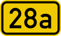
Branch of the federal road 28
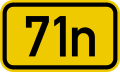
Substitute Federal Road 71


Downgrading of federal highways
According to Section 2 (4) FStrG , federal highways are to be downgraded or abandoned if the supra-regional traffic significance has been taken over by a parallel motorway that has since been built. As early as 1986, the Federal Audit Office complained that many sections of federal highways are still being run as federal highways and are maintained by the federal government, although this condition is met. In 1995 the federal government decided on a graduation concept. The federal states then defended themselves before the Federal Constitutional Court against a related “compulsory” assumption of the building responsibility until the success in 2000 . As a result, federal policy - presumably because of the impossibility of shifting construction loads unilaterally to the states - no longer pushed the procedure forward.
In 2009 the Federal Council heard a proposal for an amicable settlement between the federal and state governments. In October 2011, the Conference of Transport Ministers approved the conclusion of corresponding federal-state agreements. Since then, more and more federal road sections have been rededicated as state, district or municipal roads.
Austria
Systematics
Federal highways A and S
→ see also: List of motorways and expressways in Austria


The federal highways are divided into:
- Bundesstraßen A (federal motorways) - these are roads laid out without a plan that are suitable for high-speed traffic and have special junctions for entry and exit ( motorways );
- Federal highways S (federal highways) - these are other roads suitable for high-speed traffic.
The classification as a federal motorway or federal expressway says nothing about the classification according to the road traffic regulations. Several federal highways are motorways in the sense of the road traffic regulations (plan-free, separate lanes, maximum speed 130 km / h instead of 100 km / h).
Some of these streets, such as the A26 and S8, are only being planned or under construction, but have already been included in the directories of federal highways.
Former federal highways B

The former federal highways B, the actual historical federal highways, were transferred to the administration of the federal states on April 1, 2002 , the term federal road B for these roads was omitted in the Federal Roads Act (BStG 1971) without replacement. These federal highways were designated with a capital "B" and a consecutive number (for example B 1, B 10 or B 83). Differences were the main roads to traffic regulations in federal road priority (blue square panel with the number of federal road in white letters) and national road without priority (yellow circular table with the number of federal highway in black). With the transfer of federal highways B to state administration, the StVO was also changed and the federal highways with priority became roads with priority . The federal highways without priority were canceled without replacement according to the StVO. The associated information boards on these streets had to be removed by the end of 2005; new ones were no longer allowed to be erected. Nevertheless, such traffic signs can still be found occasionally on the former “federal roads without priority” (→ road system in Austria, “Historically: federal road without priority” ).
properties
Federal roads in Austria are all those streets that are designated as such in the registers belonging to the Federal Roads Act or that are declared to be by federal law. The course is determined in detail by an ordinance issued by the Federal Minister for Transport, Innovation and Technology. The use of the federal roads is open to everyone within the framework of the road police and motor vehicle regulations. The federal government is responsible for the construction load in Austria. However, in 1982 the latter transferred the maintenance and financing tasks to ASFINAG . The federal highways also include related facilities such as noise protection facilities , tunnels , bridges , underpasses, retaining walls as well as devices for collecting the motorway toll and the like.
Interventions in the rights of third parties are permitted in favor of federal highways.
- Expropriations (against indemnification within the meaning of § 1323 ABGB ) are possible for the construction, maintenance or redesign of federal highways including the associated structures .
- No new buildings, extensions or conversions may be carried out at a distance of up to 40 m from a motorway and 25 meters from an expressway.
- The management of adjacent properties can also be restricted due to the possible threat to the existence of the road or linked to obtaining a permit:
- It can be ordered that adjacent forests with a width of four meters on both sides are to be felled, thinned out or managed in a certain way.
- Acoustic advertisements are not permitted at a distance of 100 meters, optical advertisements are only permitted under certain conditions and with official approval.
- Landowners must tolerate the erection of snow fences and the like, with compensation for any damage.
- The discharge of water (e.g. from roofs ) onto the federal road is prohibited. Conversely, the neighbors have to tolerate the runoff of water from the main road and the deposition of snow .
Brazil
Brazilian highways are known as rodovias federais (federal highways ) when they pass through several Brazilian states.
Canada
The network of federal highways in Canada consists of:
- the Trans-Canada Highway , which is jointly maintained by the federal government and the provinces
- the Federal Arteries in the National Capital Region , by the NCC are maintained by the Government of Canada is under
literature
- Patricia Clough: Aachen - Berlin - Königsberg: A journey through time along the old Reichsstrasse 1. Deutsche Verlagsanstalt, Munich 2007.
- Traffic law notifications. Kirschbaum Verlag GmbH, 2006.
Web links
- The explained traffic sign catalog: sign 401 federal road
- Directory and history of the federal and former imperial roads in Germany
Individual evidence
- ^ BMVI: Length statistics
- ↑ Patricia Clough: Aachen - Berlin - Königsberg: A journey through time along the old Reichsstrasse 1 . page 12
- ↑ Minutes of the meeting, page 71159
- ^ PDF with self-illustration "The Reichsamt für Landesaufnahme und seine Kartenwerke", page 268, from 1931, digitized as in the digital aviation library ; PDF with text "Starting point of the trunk road measurements" by Herbert Liman from the state survey and geographic base information Brandenburg
- ^ Kurt Kodal: Road Law . 7th edition, Munich 2010, page 459
- ↑ Walther Hubatsch (Ed.): Outline of German administrative history. Series A Prussia Vol. 7 (Rhineland), Marburg 1978, page 101
- ^ Kurt Kodal: Straßenrecht , 7th edition, Munich 2010, page 459
- ↑ § 3 of the Act on the Property Relationship of Federal Motorways and Other Federal Highways of Long-Distance Traffic of March 2, 1951 ( Federal Law Gazette I p. 157 )
- ↑ Expert opinion of the Federal Commissioner for the Efficiency of Administration in Federal Highway Construction from October 11, 2004 (PDF, 1.1 MB, accessed on November 27, 2015)
- ↑ West Berlin federal highways
- ↑ Recognizable, for example, in Berlin city maps by R + V Verlag from the 1980s
- ↑ Graduation concept of the Federal Ministry of Transport and Digital Infrastructure for federal highways parallel to the autobahn ( Memento from July 4, 2016 in the Internet Archive )
- ↑ Judgment of the Federal Constitutional Court of July 3, 2000
- ↑ See also federal highways remain a federal matter (report from RP online)
- ↑ Gradation of federal highways ( Memento from March 4, 2016 in the Internet Archive )
- ↑ Federal highway investments are bearing fruit