
Berlin center
|
Middle district of Berlin |
|
|---|---|
  |
|
| Coordinates | 52 ° 31 '10 " N , 13 ° 24' 24" E |
| surface | 10.69 km² |
| Residents | 102,465 (Dec. 31, 2019) |
| Population density | 9585 inhabitants / km² |
| Postcodes | 10115, 10117, 10119, 10178, 10179 |
| District number | 0101 |
| structure | |
| Administrative district | center |
| Locations |
(Historic districts) |
Mitte is a Berlin district in the district of the same name and includes part of the historic districts of Berlin. In it lies the eastern center of the German capital with the former city centers of Alt-Berlin and Alt-Kölln , the Brandenburg Gate , Unter den Linden , the Humboldt University , the Museum Island and the television tower . In Mitte there are numerous federal institutions, the Berlin Senate in the Rotes Rathaus and the Berlin House of Representatives in the Prussian state parliament, as well as numerous embassies.
Until the administrative reform in 2001, the district was a separate district. This Mitte district was merged with the Tiergarten and Wedding districts to form the new Mitte district of Berlin.
The place name Mitte is always used without an article, ie “I live in Mitte”, “We're going to Mitte”. In common parlance, this usually refers to the Mitte district, not the new Mitte district that has been created through merger.
location
The district Mitte was formed as a district in 1920 . It covers the core area of old Berlin. The borders mostly run across the historic districts. Only the western border coincides with the course of the old customs wall ; there with the Brandenburg Gate lies the customs gate to the west in the direction of the city of Brandenburg . Some place names that refer to other city gates of the customs wall are now in neighboring districts, such as the Kottbusser Tor and the Frankfurter Tor , which are located in Kreuzberg and Friedrichshain .
structure


The district of Mitte is divided into different regions.
Historic districts
A formal division into the historic districts, as it existed until 1920, goes back to the former twin cities of Berlin - Kölln and its suburbs. Some of the historic districts were not limited to Berlin-Mitte, but also extended to neighboring districts. The boundaries and names of the historic districts have changed several times over the years. The figure on the right shows the last officially valid classification from 1920.
- I old Berlin
- II Alt-Kölln
- III Friedrichswerder
- IV Dorotheenstadt
- V Friedrichstadt (extends to Kreuzberg )
- XI Luisenstadt (extends to Kreuzberg)
- XII Neu-Kölln
- XIII Stralauer Vorstadt (extends to Friedrichshain )
- XIV royal city (extends to Prenzlauer Berg and Friedrichshain )
- XV Spandau suburb
- XVI Rosenthaler Vorstadt (extends to Prenzlauer Berg and Gesundbrunnen )
- XVII Oranienburger Vorstadt (extends to Wedding and Gesundbrunnen )
- XVIII Friedrich Wilhelm City
Statistical areas
In the area of the district of Mitte there are eight statistical areas, some of which are based on the historical districts, but also summarize some of these districts.
- 098 Friedrich Wilhelm City
- 099 Oranienburger Vorstadt (including Rosenthaler Vorstadt)
- 100 Spandau suburb
- 101 Königsstadt (extends to the Spree, including old Berlin)
- 102 Dorotheenstadt (extends to the Spree, including parts of Friedrichswerder and Museum Island )
- 103 Friedrichstadt (extends to the Spree, including parts of Friedrichswerder and Humboldtforum )
- 104 Luisenstadt (including Neu-Kölln and Fischerinsel )
- 105 Stralauer Vorstadt

Environmentally oriented rooms
The lifeworld oriented spaces (LOR) were determined by a Senate resolution in August 2006 as a new spatial basis for planning, forecasting and monitoring demographic and social developments in Berlin. In the Mitte district there are three district regions divided into a total of twelve planning areas:
-
12 - District Region Government Quarter
- 1201 Wilhelmstrasse
- 1202 Unter den Linden Nord
- 1203 Unter den Linden south
- 1204 Leipziger Strasse
-
13 - District region Alexanderplatz
- 1301 Charité district
- 1302 Oranienburger Strasse
- 1303 Alexanderplatzviertel
- 1304 Karl-Marx-Allee
- 1305 Heinrich-Heine-Viertel West
- 1306 Heinrich-Heine-Viertel Ost
-
14 - District region Brunnenstrasse Süd
- 1401 Invalidenstrasse
- 1402 Arkonaplatz
History of the historic districts
.png)
North: Spandauer Vorstadt, Oranienburger Vorstadt and Rosenthaler Vorstadt

The north of the district is still characterized by dense pre-war buildings. In particular, the Spandauer Vorstadt , the Oranienburger Vorstadt and the Rosenthaler Vorstadt went through a strong gentrification process after the political change . Most of the old buildings in this area are currently being renovated and the area is characterized by restaurants and retail outlets.
Oranienburger Strasse is a supraregional popular nightlife area with numerous bars and restaurants, while the area around Rosenthaler Platz with the Hackesche Höfe , Rosenthaler Strasse , Weinmeister Strasse and Neue-Schönhauser Strasse is characterized by upscale retail.

Before the Shoah , many Jews lived here after Friedrich Wilhelm I ordered all Jewish citizens of Berlin without their own land to settle here in 1737 . In the 19th century, Jewish immigrants from Eastern Europe came along and found a large Jewish community here. Particularly noteworthy is the New Synagogue from 1866, which, with its golden dome, is a striking landmark in the area. During the November pogroms , through the bombing of Berlin in World War II and the subsequent neglect on the part of the GDR government (hardly any community member had survived the Holocaust ), the building was damaged, but was restored after the political change and opened in 1995.
Before the Second World War , the Monbijou Castle , the traditional residence of the Prussian queens, was located in the Spandau suburb . After the end of the monarchy there was a Hohenzollern museum in its rooms . The palace survived the war with severe damage, but was not rebuilt, but torn down in 1959 for ideological reasons by order of the East Berlin magistrate .
East: Alt-Berlin, Alt-Kölln, Friedrichswerder, Königsstadt and Stralauer Vorstadt

Berlin emerged as a twin city Berlin - Kölln at the Spree crossing , today's Mühlendamm. Due to the stacking right or market right, all goods transported on the Spree had to be offered on the Berlin whey market or the Köllnischen fish market . The cities flourished and were also members of the Hanseatic League.
The two arms of the Spree are now heavily built on, and the Museum Island with the Berlin Cathedral , the Lustgarten and the capital's most important museums is located in the north . In the middle there used to be the Berlin City Palace (blown up and demolished in 1950) and in the same place since 1976 the Palace of the Republic , the demolition of which was completed in 2009.
The Humboldt Forum with the historicizing facade of the destroyed castle has been built here since 2013 . After its opening in 2020, it will house and exhibit the collections of non-European art of the Prussian Cultural Heritage Foundation .
The Friedrichswerder Church housed a Schinkel museum until 2012 . Due to the construction of further building projects in the immediate vicinity of the church, the foundation of the building was damaged and the museum had to be closed and Schinkel's figures had to be outsourced.
In the immediate vicinity, before it was destroyed in the course of the Second World War, the Berlin Building Academy stood , the building of which was also designed by Karl-Friedrich Schinkel . A reconstruction of the building academy has been planned for a long time and is targeted for the year 2020/21.

On the east bank of the Spree, where the densely built-up old Berlin once was, today a large square with the television tower extends to Alexanderplatz . After the war and the GDR urban planning of the 1950s and 1960s, only St. Mary's Church remained from the old development of the district .
The Red Town Hall and the Nikolaiviertel with the oldest church in Berlin are located near the Molkenmarkt . The district by the Nikolaikirche was badly damaged during the Second World War. In 1987, on the occasion of the 750th anniversary of Berlin, a new residential area made up of prefabricated buildings and reconstructed residential buildings was named Nikolaiviertel.
Alt-Kölln was comparatively little damaged as a district during World War II, but the historic development was demolished by the GDR government in the post-war years . In the area of the Brüderstraße apartment houses were built in prefabricated construction and south of the Gertraudenstraße the residential area Fischerinsel was built, the high-rise buildings of which still characterize this part of the old center.
In place of the Petrikirche , which was demolished in 1964, the House of One is to be built by 2018 , a house of God that unites three of the major world religions of Judaism , Christianity and Islam as a synagogue , church and mosque in one building.
In the royal city and the Stralau suburb to the north and east of Alexanderplatz, housing estates were also built using prefabricated panels after the Second World War , some of which extend into the Friedrichshain district .
South: Neu-Kölln and Luisenstadt
The southern locations of Luisenstadt and Neu-Kölln (also Neukölln am Wasser ) in Mitte also suffered severe damage during the Second World War. The southern part of Luisenstadt came to the Kreuzberg district after the formation of Greater Berlin in 1920 and was therefore in the former West Berlin after the division of Germany .

The Märkisches Museum in Neu-Kölln tells the story of the city of Berlin. In the adjacent Köllnischer Park is the bear kennel, where bears have been kept as Berlin's heraldic animals since 1939. The kennel has been vacant since the death of the last bear Schnute in October 2015.
The part of Luisenstadt around Jannowitzbrücke belonging to Mitte is characterized by the residential blocks of the Heinrich-Heine-Quarter and industry.
At the southern end of Heinrich-Heine-Straße there was a border crossing to the Kreuzberg district - located in the former West Berlin - during the division of Germany.
In the Luisenstadt, historical buildings were preserved in isolated places around the Engelbecken . The center of the symmetrical area is the Saint Michael Church , which suffered severe damage during the last days of the war and was preserved as a ruin. To this day, the undestroyed choir is used by the community as a church.
As a result of German reunification , the symmetry of the ensemble between the Wassertorplatz on the West Berlin side and the Engelbecken on the East Berlin side with the line of sight from the Luisenstädter Canal gardens to the St. Michael Church has been restored
West: Dorotheenstadt, Friedrichstadt and Friedrich-Wilhelm-Stadt

In Dorotheenstadt , around the boulevard Unter den Linden , most of the culturally and historically relevant buildings were at least externally restored during the GDR era. One exception is Pariser Platz , which remained undeveloped after the post-war clean-up until after the political change. Apart from the Brandenburg Gate , no building here survived the war.
In the immediate vicinity of the Brandenburg Gate, close to the area where once Hitler's New Reich Chancellery was located, was built by 2005, the Memorial to the Murdered Jews of Europe , which of the millions of genocide of European Jews by Nazi Germany should remember. In the neighboring Tiergarten district , other memorials also commemorate the victims of National Socialism in Germany , namely the memorial and information center for the victims of the National Socialist "euthanasia" murders , the memorial for homosexuals persecuted under National Socialism and the memorial for the Sinti murdered under National Socialism and Roma of Europe .
In Friedrichstadt , the Gendarmenmarkt , once laid out based on the Italian model, was restored in the 1980s after the ruins of the square had lay fallow for decades . During the SED dictatorship, the square was renamed Platz der Akademie in 1950 until it was given its old name back in 1991 after German reunification .
Numerous streets in Friedrich-Wilhelm-Stadt were also spared from the Second World War. Long-established institutions such as the Charité , the German Theater , the Theater am Schiffbauerdamm and the Friedrichstadt-Palast are located here to this day .
District Mayor from 1920 to 2000
Below are the mayors of Mitte between the founding of Greater Berlin in 1920 and the administrative reform of 2001. During this period, today's district of Mitte was a district with the same extent.
| Period | Surname | Political party |
|---|---|---|
| 1921-1930 | Fritz Schneider | SPD |
| 1931 – Feb. 1933 | Gordan |
Party affiliation unknown |
| March 1933 | Werner Steinhoff | DNVP |
| Apr. 1933 – July 1935 | Wilhelm Lach | NSDAP |
| Aug. 1935 – Sep. 1936 | Otto Born | NSDAP |
| Oct. 1936 – Apr. 1940 | Walter Erbe | NSDAP |
| May 1940 – Apr. 1942 | Walter Brümmel | NSDAP |
| May 1942 – Apr. 1945 | Gerhard Brümel | NSDAP |
| May 1945 | Wilhelm Friday | SPD |
| May 1945 – Aug. 1946 | Willi Kohl | KPD / SED |
| Aug. 1946 – Oct. 1946 | Paul Letsch | SED |
| Dec. 1946 – Dec. 1948 | Erich Bab | SPD |
| Dec. 1948 – Sep. 1956 | Wilhelm Thiele | SED |
| Sep 1956-Sep. 1976 | Kurt Goldberg | SED |
| Sep 1976 - May 1984 | Horst Kreuter | SED |
| May 1984 – Febr. 1990 | Gottfried Kroschwald | SED |
| Feb 1990-May 1990 | Ulrich Fahl | CDU |
| June 1990-May 1992 | Benno Hasse | Independent Alliance 90 / The Greens |
| May 1992 – Dec. 1996 | Gerhard Keil | SPD |
| Dec. 1996 – Dec. 2000 | Joachim Zeller | CDU |
Residents
The Mitte district has 102,465 inhabitants (as of December 30, 2019), making it the second most populous district in the Mitte district. His average age is between 40 and 42 years. The proportion of the foreign population in the district is 18.3%, the proportion of the population with a migration background is 28.5%.
Attractions
As a landmark that can be seen from afar , the Berlin TV tower near Alexanderplatz represents the center of Berlin-Mitte, at the foot of which is the Red City Hall . Starting with the Schlossbrücke, there are numerous buildings on Unter den Linden boulevard : the Kronprinzenpalais , the State Opera , the Neue Wache and the Humboldt University . The Brandenburg Gate on Pariser Platz forms the border with the Großer Tiergarten .
- Boulevard Unter den Linden

Main building of the Humboldt University , Bebelplatz

Law faculty of the Humboldt University in the building of the old library
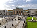
Pariser Platz with the Brandenburg Gate


The historical nucleus of Berlin's museum landscape is located on Museum Island and includes the following museums: Old National Gallery , Pergamon Museum , Old Museum , Bode Museum and New Museum . Other important museums in Mitte are the German Historical Museum in the Armory, the Museum of Natural History and the Märkisches Museum .
- Museum Island
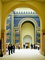
Ishtar Gate in the Pergamon Museum

Bust of Nefertiti in the Neues Museum


As important buildings are at the Gendarmenmarkt the German and the French Cathedral .
- Gendarmenmarkt


In the area of Friedrichstrasse and Oranienburger Strasse are the Friedrichstadt-Palast and the New Synagogue as well as the Hackesche Höfe .
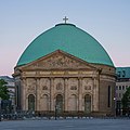
As a religious following are known: Berlin Cathedral , Evangelical Lutheran Church of Berlin , French Friedrichstadtkirche , Friedrichswerder Church (now used as Schinkel Museum), St. Nicholas Church , St. Hedwig's Cathedral , St. Mary's Church , St. Michael's Church , Church of St. Sophia , Parochialkirche (singing Church) French Cathedral , German Cathedral (today: Museum of the History of Democracy in Germany), Chapel of Reconciliation and the Zion Church .
- Sacred building in Berlin-Mitte

Berlin Cathedral , Berlin's largest church

Chapel of Reconciliation, part of the Berlin Wall Memorial
St. Hedwig's Cathedral , Berlin's main Catholic church


The following theaters are located in Mitte: the Berliner Ensemble , the German Theater (with chamber plays), the Volksbühne , the Komische Oper , the Konzerthaus (formerly known as the "Schauspielhaus"), the Friedrichstadt-Palast , the Chamäleon variety theater in the Hackesche Höfe, the cabaret Die Distel as well as the Maxim-Gorki-Theater / Sing-Akademie , the Theaterhaus Berlin Mitte as a central production and communication location for the independent performing arts, the Small Theater Berlin-Mitte and the theater discounter . The supraregional media and theater festival is the annual Neuropolis .
In addition, Mitte has other noteworthy buildings and facilities: the St. Hedwig Hospital from 1846, the Charité , the Dorotheenstadt , the Invalidenfriedhof and the Jewish cemetery , the Nikolaiviertel and the Scheunenviertel .

traffic

train
The Berlin Stadtbahn, completed in 1882, runs in an east-west direction on brick viaduct arches and bridges through the city center. Regional train stations are Alexanderplatz and Friedrichstrasse . Until 1990, Friedrichstrasse station was the border station between East and West Berlin. The trains from the east and west networks ended on separate platforms, all long-distance trains to the Federal Republic stopped here and were checked. The trains of the underground north-south S-Bahn stopped at the underground platform to transfer passengers from West Berlin to the U6 underground line and to the westbound S-Bahn. This platform and the subway station were not accessible to East Berliners and GDR citizens without a visa.
Since the political turning point , the S-Bahn has been running continuously again, and the S-Bahn and U-Bahn trains stop again at all stations that were closed between 1961 and 1990 . In addition to the north-south underground line U6 ( Alt-Tegel - Alt-Mariendorf ), the U8 runs under Alexanderplatz, which is also served by the U5 (to Hönow ) and the U2 ( Ruhleben - Pankow ). The stations of the U2 line are, along with those of the U3, the most beautiful underground stations in Berlin, which opened in 1908 and 1913 respectively. The short underground line U55 from the main station to the S + U-Bahn station Brandenburger Tor was opened in 2009 and has no connection to the rest of the underground network for the time being. It is to be extended to Alexanderplatz by 2020 and then merge with the U5 line.
|
|
|
|
Streets

On the west bank of the Spree is the Zeughaus , from which the street Unter den Linden with many magnificent buildings extends to Pariser Platz with the Brandenburg Gate . Further south stretches from Molkenmarkt the Leipziger Strasse to Potsdamer Platz . To the north of the Spree island , Oranienburger Strasse extends from the Hackesche Höfe to the Oranienburger Tor . Friedrichstraße begins there and runs south through the entire district.
See also
- List of cinemas in Berlin-Mitte
- List of streets and squares in Berlin-Mitte
- List of cultural monuments in Berlin-Mitte
- List of stumbling blocks in Berlin-Mitte
- List of street fountains in the Mitte district of Berlin
literature
- Albrecht Behmel : Homo Sapiens Berliner Art . Schenk, 2010.
- Cornelia Carstens et al. : Women on the Spree. A walk through history. be-bra, 1999.
- Irene Liebmann: The quiet center of Berlin. Research on Hackescher Markt. Berlin 2002.
Web links
- Information on the Mitte district, Mitte district office of Berlin
- Picture gallery of places / squares in the Berlin-Mitte district
Individual evidence
- ↑ Berlin address book 1920
- ↑ a b Regional reference system for the state of Berlin, Berlin 2013.
- ↑ Scheunenviertel - Google search. In: google.de. Retrieved August 12, 2016 .
- ↑ Tour of the Scheunenviertel. (No longer available online.) January 24, 2015, archived from the original on August 12, 2016 ; accessed on August 12, 2016 .
- ↑ Friedrichswerder Church: A jewel is destroyed. Retrieved December 22, 2018 .
- ↑ Patrick Goldstein: Schinkel's building academy is being rebuilt. September 20, 2017. Retrieved December 22, 2018 .
- ↑ Michael Klemp: Home. In: berliner-historische-mitte.de. Retrieved August 12, 2016 .
- ↑ District office in the middle almost completely. In: Neues Deutschland , December 21, 1946, p. 6.
- ↑ Inhabitants registered under registration law in the state of Berlin on June 30, 2011 (PDF; 2.7 MB)

Gesundbrunnen | Hansaviertel | Middle | Moabit | Zoo | Wedding

Middle (1) | Tiergarten (2) | Wedding (3) | Prenzlauer Berg (4) | Friedrichshain (5) | Kreuzberg (6) | Charlottenburg (7) | Spandau (8) | Wilmersdorf (9) | Zehlendorf (10) | Schöneberg (11) | Steglitz (12) | Tempelhof (13) | Neukölln (14) | Treptow (15) | Köpenick (16) | Lichtenberg (17) | Weissensee (18) | Pankow (19) | Reinickendorf (20) | Marzahn (21) | Hohenschönhausen (22) | Hellersdorf (23)