
Dorotheenstadt

I Alt-Berlin II Alt-Kölln (Spreeinsel) III Friedrichswerder IV Dorotheenstadt V Friedrichstadt XI Luisenstadt XII Neu-Kölln XIII Stralauer Vorstadt XIV Royal Town XV Spandauer Vorstadt XVI Rosenthaler Vorstadt XVII Oranienburger Vorstadt XVIII Friedrich-Wilhelm-Stadt Sources: Contents: Berlin address book, map base: District Office Mitte von Berlin


The Dorotheenstadt is a historic district in present-day Berlin district of Mitte . It was founded in 1674 and was named after the Electress Dorothea in 1681 .
geography
Dorotheenstadt is bounded by Ebertstraße in the west, the Spree in the north, the Kupfergraben in the northeast, Dorotheenstraße and the course of the former fortress ditch or linden tunnel in the east and Behrenstraße in the south.
It is connected to the Friedrich Wilhelm City via the Marschall Bridge and the Weidendammer Bridge . The Ebertbrücke and Monbijoubrücke lead to the Spandau suburb . In the south, Dorotheenstadt borders on Friedrichstadt .
history
In 1670, the Great Elector Friedrich Wilhelm gave his second wife Dorothea Sophie of Schleswig-Holstein-Sonderburg-Glücksburg the Cöllnian Vorwerk Tiergarten located between the Berlin fortress wall and the Great Tiergarten . For the area initially called Neustadt , a development plan based on plans by Joachim Ernst Blesendorf with a strictly right-angled road network was established, bounded in the north by Georgenstrasse and in the west by Schadowstrasse; the southern border was the Behrenstrasse . On January 2, 1674, the Neustadt received the electoral city privilege and in 1681 it was renamed Dorotheenstadt in honor of the Electress Dorothea. In 1687 the Dorotheenstädtische Kirche was completed on today's Neustadt church square between Dorotheen- and Mittelstrasse . In 1710, Dorotheenstadt was combined with the previously independent cities of Berlin , Kölln , Friedrichswerder and Friedrichstadt to form the “Royal Capital and Residence City of Berlin” and expanded in the course of the 18th century to the Spree in the north and today's Brandenburg Gate in the west . In addition to the dignified and elegant Unter den Linden area , a pulsating city life has developed around the Friedrichstrasse station since the opening of the Berlin light rail in 1882 . The population was 20,144 in 1867 and 11,558 in 1910.
With the law on the formation of a new Berlin municipality ( Greater Berlin Law ), Dorotheenstadt was incorporated into the newly created Mitte district in 1920 . After severe destruction in the Second World War , many historical buildings were rebuilt during the GDR era, including the Palais des Prinzen Heinrich (main building of the Humboldt University ), the Unter den Linden State Opera and the Old Library , while the ruins of the Dorotheenstadt Church were demolished in 1965. Since the German reunification , the development of the western Dorotheenstadt around the Pariser Platz has been completed again.
politics

coat of arms
The coat of arms of Dorotheenstadt shows the red Brandenburg eagle with the crown of the elector, looking to the right . On the eagle's chest you can see a blue shield with a golden lily scepter.
Federal government
The Federal Government's Press and Information Office is located at Dorotheenstrasse 84. It is located on the historic site of the former Royal Yorck Lodge, on which the Villa Kamecke von Schlueter stood until 1945 and also uses the former Postscheckamt Berlin Am Reichstagufer .
The Jakob-Kaiser-Haus on both sides of Dorotheenstrasse between Wilhelmstrasse and Ebertstrasse is the largest parliament building and houses offices for members of parliament.
Embassies
The major industrial nations of Europe and the USA have had their messages in Dorotheenstadt for a long time. The embassy of the United States resides at Pariser Platz 2 and the French embassy at number 5 . The British Embassy is located at Wilhelmstrasse 70/71 and the embassies of Russia (No. 63–65) and Hungary (No. 76) on Unter den Linden . The embassy of the Republic of Maldives is also located at Pariser Platz 4a.


economy
media
The two largest public television companies have their Berlin studios in Dorotheenstadt. The ARD capital city studio is located at Wilhelmstrasse 67a at the corner of Reichstagufer and the ZDF capital city studio is located in Zollernhof, Unter den Linden 36–38 .
In the years 2000–2003, Bertelsmann AG and Bertelsmann Stiftung set up their capital city representative on Unter den Linden 1, as a reconstruction of the old headquarters that had been destroyed in World War II .
science and education
Dorotheenstadt is a traditional location for various educational institutions.
Universities
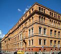
Today's Humboldt University has resided in the former palace of Prince Heinrich , Unter den Linden 6, since 1809 .
The Hertie School of Governance private university will open its doors in the building complex Dorotheenstrasse 96 from 2022 .
Libraries
The State Library , Unter den Linden 8, has its roots in the Royal Library , which was originally located in the chest of drawers at today's Bebelplatz. The renovation work on the listed building on the Unter den Linden site has been going on for decades. In 2013 the rebuilt central large reading room was reopened.
North of the Stadtbahn , in Geschwister Scholl-Strasse 1–3 is the Jacob and Wilhelm Grimm Center , the Humboldt University 's library , completed in 2009.
Other places of education
The first Berlin observatory was located in the Marstall building, the predecessor of the State Library, at the corner of Dorotheen- and Charlottenstraße .

Humboldt University with a monument to Alexander von Humboldt
Hertie School of Governance, from 2022
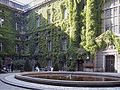
State Library Unter den Linden, Hof
.jpg)


Culture and sights
theatre
The Staatsoper Unter den Linden 7 has its origins in the royal opera that opened in 1742. The original building comes from Knobelsdorff , but has been rebuilt and changed many times - most recently by raising the ceiling in the auditorium and renovations in the stage tower in 2010-2017.
The Komische Oper is located at Behrenstrasse 55-57 . The metropolitan theater was located in this house until 1945 .
The Admiralspalast Friedrichstrasse 101 initially housed the Admiralsbad and an ice arena. The latter was later converted into a theater and, from 1955, was the replacement quarters for the Metropolitan Theater . After its liquidation in 1997, there was a brief threat of demolition before the building was reopened as the Admiral's Palace in 2005 after a long period of vacancy.
Other places of culture
The Akademie der Künste has had its headquarters at Pariser Platz since 1907 with interruptions . The Collegium Hungaricum Berlin is located at Dorotheenstrasse 12 .
Special buildings
No longer existing buildings
When the Neue Wilhelmstrasse was laid out in 1822 by the property speculator Schumann , the owner of house number 76, which stood at the future road junction, was given a higher and larger one as a replacement, on the ground floor of which Schinkel designed a passage lined with colonnades . It existed until the end of the 19th century. Then the component was demolished across the street. Finally, the remaining peripheral buildings had to give way to new corner houses.
Listed buildings


literature
- Erika Schachinger: The Dorotheenstadt 1673–1708. Böhlau Verlag, Cologne / Weimar 2001.
- Volker Wagner: The Dorotheenstadt in the 19th century (= publications of the historical commission to Berlin. Volume 94). Verlag Walter de Gruyter, Berlin / New York 1998, ISBN 3-11-015709-8 , urn : nbn: de: 101: 1-2017040514983 (Zugl .: Berlin, Techn. Univ., Diss., 1995).
Web links
Individual evidence
- ↑ Bernd Horlemann, Hans-Jürgen Mende (Ed.): Berlin 1994. Pocket calendar. Edition Luisenstadt, Berlin, No. 01280.
- ^ Friedrich Leyden: Greater Berlin. Geography of the cosmopolitan city. Hirt, Breslau 1933 (therein: Development of the population in the historic districts of Old Berlin, p. 206).
- ^ Dorotheenstädtische Church. In: kirchensprengung.de, accessed on December 29, 2018 (Tobias Köppe's private website).
Coordinates: 52 ° 31 ' N , 13 ° 23' E