
Ebertstrasse (Berlin)
| Ebertstrasse | |
|---|---|
|
|
|
 |
|
| Looking north along Ebertstrasse towards the Brandenburg Gate | |
| Basic data | |
| place | Berlin |
| District | center |
| Hist. Names |
Kasernenstrasse, Sommerstrasse, Schulgartenstrasse, Brandenburgische Kommunikation, Königgrätzer Strasse, Budapester Strasse, Friedrich-Ebert-Strasse, Hermann-Göring-Strasse |
| Connecting roads |
Scheidemannstrasse / Dorotheenstrasse , Stresemannstrasse |
| Cross streets |
Behrenstrasse , Hannah-Arendt-Strasse , In den Ministergärten , Vossstrasse , Lennéstrasse |
| Places |
Friedrich-Ebert-Platz square on March 18th , Potsdamer Platz |
| use | |
| User groups | Pedestrian traffic , bicycle traffic , car traffic , public transport |
| Technical specifications | |
| Street length | approx. 600 meters |
The Ebertstraße is a politician after Friedrich Ebert called four-lane main road in Berlin's Mitte district .
Location and course
Ebertstraße runs in a north-south direction. Friedrich-Ebert-Platz is at the northern end of the street . Here Scheidemannstrasse runs from the west and Dorotheenstrasse from the east towards Ebertstrasse. In its course it crosses the Platz des 18. März , where it passes immediately west of the Brandenburg Gate and where the Straße des 17. Juni, coming from the west , joins. In the south it joins the Potsdamer Platz street , whereupon this continues further south into Stresemannstrasse . Almost all of Ebertstrasse is located in the Mitte district , only the western sidewalk of the street section north of the Brandenburg Gate belongs to the Tiergarten district . Since the Pariser Platz in a pedestrian area was redesigned, the section Ebertstraße north of the Brandenburg Gate, 18th of March and Strasse des 17. Juni on a part of the common route out federal highways B 2 and B 5 .
history

Today's Ebertstrasse or its sections have already had numerous other names in the course of their history: Kasernenstrasse (from around 1767 to 1859 north of the Brandenburg Gate), Sommerstrasse (named after City Councilor Carl August Heinrich Sommer , 1859 to 1925 at the same location); to the south, then Schulgartenstrasse (outside the Berlin customs wall , named after the local school garden by Johann Julius Heckers , 1831 to 1867), Brandenburgische Kommunikation (1845 to 1867 within the customs wall); then Königgrätzer Straße (1867 to 1915). In order not to snub the Austro-Hungarian allies in World War I by remembering the Battle of Königgrätz , but to honor it, it became Budapester Strasse in 1915 . As early as 1925, less than two months after Friedrich Ebert's death, the street was named Friedrich-Ebert-Straße : Ebert became a member of the Reichstag that met on this street for the first time in 1912 , and the back (garden gate) of the Reich President's Palace was on the same street.
After eight years, right at the beginning of the Nazi era , it was renamed Hermann-Göring-Straße in 1933 after the then NSDAP President of the Reichstag . This name was no longer used after the end of World War II in 1945, but it was not officially renamed until July 31, 1947. In the post-war period , Ebertstrasse was the border between the Soviet and British sectors of Berlin. In 1961 the Berlin Wall was also built along this street.
The square-like section on the east side of the Reichstag building, which used to belong to Ebertstrasse, has been called Friedrich-Ebert-Platz since 1999 and extends to the intersection of Dorotheen- and Ebertstrasse. It was redesigned in the course of the redesign in the Spreebogen and in the government district after the capital city resolution. The former course of the Berlin Wall is indicated by a stone band in the ground.
In the underground
Underground Ebertstraße is since 1936 a two-storey railway tunnels in the lower floor tram -distance from Potsdamer Platz station to station Brandenburg Gate passes and the upper floor as sweeping and parking area for the Südringspitzkehre was built. As one of the changes due to the plans for a " world capital Germania " announced after the start of construction of the north-south S-Bahn, the introduction of the Südringpitzkehre in the north-south tunnel was dispensed with and so this upper floor has only been used as a storage facility for those in the North-south S-Bahn used cross-city lines. The upper floor, called “hayloft” in railway jargon, could become the centerpiece for another north-south S-Bahn (planned under the name S21) if the gap between the S-Bahn station under construction in the main train station and this one at the level of the Behrenstrasse ending part is closed.
Buildings and monuments
Some of Berlin's most important sights are located on Ebertstrasse. The Reichstag building is at the northern end , followed by the Brandenburg Gate. From Platz des 18. März, which is located along Ebertstraße, there is a clear view of the Berlin Victory Column along Straße des 17. Juni . Further sights are the US embassy , whose west side is directly on Ebertstrasse, the memorial for the murdered Jews of Europe (also Holocaust memorial , also bordering Ebertstrasse to the east) and the memorial for homosexuals persecuted under National Socialism (opposite the Holocaust memorial) Memorial west of Ebertstrasse). Also opposite the Holocaust memorial is a Goethe memorial in the Großer Tiergarten, which is directly adjacent to Ebertstrasse . On the street In the ministerial gardens east of Ebertstraße are the buildings of the state representatives to the federal government of Rhineland-Palatinate , Saarland and Hesse as well as the houses shared by Lower Saxony and Schleswig-Holstein as well as Brandenburg and Mecklenburg-Western Pomerania . The buildings of Potsdamer Platz border the southern end of the street.

A bird's eye view of the Reichstag building , the northern end of Ebertstrasse can be seen in this picture at the bottom right
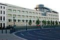
West side of the US Embassy on Ebertstrasse
View from Ebertstrasse over the Memorial to the Murdered Jews of Europe


Web links
-
Ebertstrasse. In: Street name lexicon of the Luisenstädtischer Bildungsverein (near Kaupert )
- Kasernenstrasse . In: Luise.
- Summer street . In: Luise.
- Schulgartenstrasse . In: Luise.
- Brandenburg communication . In: Luise.
- Königgrätzer Strasse . In: Luise.
- Budapester Strasse . In: Luise.
- Friedrich-Ebert-Strasse . In: Luise.
- Hermann-Goering-Strasse . In: Luise.
Individual evidence
- ↑ Now Friedrich-Ebert-Strasse . In Vossische Zeitung , July 14, 1925, evening edition, p. 4.
Coordinates: 52 ° 30 ′ 48.5 ″ N , 13 ° 22 ′ 37.6 ″ E