
Stresemannstrasse (Berlin)

The Stresemannstraße is located in the Berlin districts of Kreuzberg (odd house numbers from 15 to 127 and even numbers from 28 to 110) and middle (even numbers 120-130). It has been named after the politician Gustav Stresemann (1878–1929) since February 1930, with an interruption between 1935 and 1947 .
Course and history
The street begins in the north at Potsdamer Platz at the level of Erna-Berger-Strasse. It runs in a south-easterly direction over Askanischer Platz and Ida-Wolff-Platz and flows into Wilhelmstrasse .
The street was built around 1831 with the city expansion and was part of the Berlin customs wall , which was set up to monitor trade within the city limits of that time. Between Potsdamer and Anhalter Tor it was called Potsdamer Communication and continued to the southeast as Hirschelstrasse . The section from the Anhalter Tor to the Hallesches Tor was called Anhaltische Communication . After the end of the German War , the entire street was renamed Königgrätzer Strasse in 1867 to commemorate the battle of Königgrätz on July 3, 1866, in which the Prussian troops defeated the armies of Austria and Saxony near the village of Sadowa . In honor of the Foreign Minister of the Weimar Republic who had died the year before, the name was changed to Stresemannstrasse in 1930. On the occasion of the reintegration of the Saar area , it was run as Saarlandstrasse from 1935 and has had its current name again since 1947.


With the construction of the Berlin Wall in 1961, the section belonging to the Mitte district became part of the death strip . Much of the building was destroyed by the Second World War, so that there was increased new construction activity only in the late 1980s with the International Building Exhibition . Social housing construction was given priority in order to “win back neglected areas as residential areas”. Up until 1986, the zoning and building use plan planned to build a “city belt” with a motorway as a southern bypass . However, this was not implemented, so that there were some open spaces, some of which were designated as green spaces. A cultural and commercial building was also planned on the top of the block on Wilhelmstrasse, which was to form a counterpart to the house of the German Metalworkers' Association in Alte Jakobstrasse . Despite a design study by the laureate Helge Bofinger from 1983, the area initially remained undeveloped, as the Kreuzberg district did not want to do without this green area with a playground. The Willy Brandt House was later built on this site . In contrast, the restoration of the perimeter block development between Stresemannstrasse 38, 42–46 and Wilhelmstrasse 131 and 136–139, which provided for a passage development with 97 apartments, including a house with twelve senior citizens' apartments and a common room. Furthermore, a house with twelve apartments for people with spastic disabilities , a common room with a workshop and four apartment extensions were built. The planned development on the town square around Hallesche Strasse, Großbeerenstrasse and Stresemannstrasse based on Schinkelplatz with a "visible correspondence with the Kreuzberg monument " was also not implemented in favor of another open space, today's Ida-Wolff-Platz.
The former excise wall was excavated and reconstructed in 1987 on a section in the amount of house numbers 62-64. To the south of Ida-Wolff-Platz, a section of track in the median of the street is reminiscent of the Berlin connecting railway .
Buildings
There are some interesting buildings along the street, some of which are listed:
- No. 28 / Wilhelmstraße 140: Willy-Brandt-Haus , inaugurated in 1996
- No. 29: Hebbel Theater , completed in 1908
- No. 90: Deutschlandhaus , built from 1926 to 1931 together with the Europahaus
- Askanischer Platz : Rest of the portal of the new Anhalter Tor of the destroyed Anhalter Bahnhof from 1880 as well as the publishing house of the Tagesspiegel at Askanischen Platz 3 (formerly: central administration of Siemens & Halske AG , from 1912: headquarters of Accumulatoren Fabrik AG ; AFA - renamed VARTA in 1962 )
- No. 92–94: Europahaus , completed in 1931, currently the Berlin office of the Federal Ministry for Economic Cooperation and Development
- No. 128: Extension of the Prussian Ministry for Agriculture, Domains and Forests , 1913–1916, today: Federal Ministry for the Environment, Nature Conservation and Nuclear Safety
From 1928 to around 1945, the Excelsior tunnel, with a length of around 80 m in its main axis, served as an underpass for pedestrians. He connected the cross platform of the Anhalter Bahnhof station with the ground floor of the Hotel Excelsior by lifts, and also the sidewalks in front of it by stairs. Remnants of the tunnel were removed in 1985.
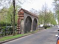
In the 1980s, part of the Berlin customs wall in Stresemannstrasse was rebuilt
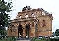
Portal fragment of the former Anhalter Bahnhof


See also
Web links
- Stresemannstrasse. In: Street name lexicon of the Luisenstädtischer Bildungsverein (near Kaupert )
literature
- International Building Exhibition Berlin 1987 - Project overview . Bauausstellung Berlin GmbH, Berlin 1987, no ISBN.
Individual evidence
- ↑ International building exhibition . In: District lexicon of the Luisenstädtischer Bildungsverein
- ↑ Internationale Bauausstellung Berlin 1987 - project overview , Internationale Bauausstellung 1984–1987 Berlin (Ed.), Berlin: Bauausstellung Berlin GmbH, 1987, p. 63. No ISBN.
- ↑ The Excelsior Tunnel Berliner Unterwelten - Documentation in text, images, plans, accessed September 20, 2018.
Coordinates: 52 ° 30 ′ 14.4 " N , 13 ° 22 ′ 58.3" E