Kreuzberg (Berlin)

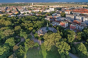
The Kreuzberg is 66 m above sea level. NHN high hill named after him in Berlin district of Kreuzberg the district of Friedrichshain-Kreuzberg .
geology

Geologically , the Kreuzberg forms the southern border of the Berlin glacial valley against the Berlin- Brandenburg plateau Teltow , to which it belongs. The Teltow is a flat undulating ground moraine landscape . The Kreuzberg is therefore not a terminal moraine . Its relatively steep northern roof goes back to the erosion of the meltwater in the Berlin glacial valley when it formed in the last ice age around 18,000 years ago.
history
The Kreuzberg was first mentioned in a document in 1290. Its historical names include Sandberg , Runder Weinberg and Tempelhofer Berg . Wine has been grown on the slopes of the mountain since the 15th century , a tradition that the harsh winter of 1740 ended in the entire Berlin area for more than 200 years; The Kreuz-Neroberger has been cultivated since 1968 .
National monument
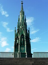
At the highest point of the elevation, King Friedrich Wilhelm III. on September 19, 1818 the foundation stone of the German national monument for the victories in the Wars of Liberation . The Russian Tsar Alexander I also attended the ceremony. The inauguration of the monument took place on March 30, 1821, the anniversary of the storming of Montmartre . On the same occasion the hill was given its current name Kreuzberg.
The monument is made of cast iron and was created by the Royal Prussian Iron Foundry (KPEG) according to plans by Karl Friedrich Schinkel . The pyramid-shaped pointed Gothic column is crowned by an iron cross , from which the name "Kreuzberg" is derived according to some representations. According to other sources, the name goes back to the cross-shaped plan of the monument. On each of the twelve outer sides of this floor plan there is a statue in a niche, which symbolizes the battle of the wars of liberation, below which is marked with place and day. The four most prominent outwardly are Groß-Görschen May 2, 1813, Leipzig October 18, 1813, Paris March 30, 1814 and Belle Alliance June 18, 1815 ( Battle of Waterloo ). The dedication under the plaque "Groß-Görschen" was written by the classical philologist August Boeckh on behalf of the king :
“The king to the people who generously offered good and blood to the fatherland at his call. The fallen for memory, the living for recognition, the future generations to emulate. "
The second half of this text (“Den Fallen…”) was taken over in many cases from war memorials of the 19th and 20th centuries, in some cases slightly changed.
Under Kaiser Wilhelm I , the almost 20-meter-high and 200- tonne monument was hydraulically lifted onto an eight-meter-high platform in 1878/1879, because the increasing development of the Tempelhofer Vorstadt prevented an uninterrupted view of the monument. On this occasion, the memorial was rotated by 21 ° so that it was now exactly in one axis with the Großbeerenstraße leading to the memorial. The lifting was carried out with twelve hydraulic presses, each with a water pressure of 30 atmospheres and a lifting force of 16 tons. Interesting in this context is the so-called " Kreuzberg knowledge ", a groundbreaking judgment by the Prussian Higher Administrative Court .
Since the 19th century
From 1888 the Viktoriapark was created at the foot of the monument with a 24-meter-high artificial waterfall, which is modeled on the Zackelfall in the Giant Mountains .
Until 1861 the Kreuzberg belonged administratively to the Tempelhofer Unterland ( Tempelhofer Vorstadt ), although from a geological point of view it was on the Oberland . After Greater Berlin was founded in 1920, he gave the then newly formed district of Hallesches Tor, to which the Tempelhofer Vorstadt was added, the name of Kreuzberg district from 1921 . As part of the general procession, the surrounding streets are almost all named after battles and generals of the wars of liberation. Exceptions are the Kreuzbergstrasse itself and the Mehringdamm , which was called Belle-Alliance-Strasse until 1947 .
The winemaking tradition on the northern slope of the Kreuzberg has been resumed since the late 1960s. The tart wine, called " Kreuz-Neroberger ", is only given away to selected guests by the district office and cannot be purchased. From Adolf Glassbrenner has been handed to the wine grown there that he called him "flagship wine": "If you een eenzjes eighth upset about the flag, runs det janze regiment together."
See also
literature
- Michael Nungesser : The monument on the Kreuzberg by Karl Friedrich Schinkel. Verlag Willmuth Arenhövel, Berlin 1987, ISBN 3-922912-19-2 .
- Falk-Rüdiger Wünsch: Kreuzberg - Tell old pictures. Sutton Verlag, Erfurt 1998, ISBN 3-89702-034-3 .
- Gerhardt Hoffmann: Kreuzberg Stories. Verlag Theodor Kastel, Berlin 2008, ISBN 978-3-9812651-0-1 .
Web links
Individual evidence
- ↑ Kathrin Chod: Kreuzberg . In: Hans-Jürgen Mende , Kurt Wernicke (Hrsg.): Berliner Bezirkslexikon, Friedrichshain-Kreuzberg . Luisenstadt educational association . Haude and Spener / Edition Luisenstadt, Berlin 2002, ISBN 3-89542-122-7 , p. 234 ( luise-berlin.de - as of October 7, 2009).
-
^ Krünitz 1839 books.google ;
Kathrin Chod: National monument on the Kreuzberg . In: Hans-Jürgen Mende , Kurt Wernicke (Hrsg.): Berliner Bezirkslexikon, Friedrichshain-Kreuzberg . Luisenstadt educational association . tape 1 : A to O . Haude and Spener / Edition Luisenstadt, Berlin 2002, ISBN 3-89542-122-7 ( luise-berlin.de - as of October 7, 2009). ;
parlament-berlin.de ( Memento of the original from March 11, 2013 in the Internet Archive ) Info: The archive link was inserted automatically and has not yet been checked. Please check the original and archive link according to the instructions and then remove this notice. - ^ Theologische Realenzyklopädie 2000 books.google.de ; see u. a. Prussian column (Friedrichsfelde) , Tannenberg monument , St. Johanniskirche (Altona) , SMS Mainz , victory monument
- ↑ Kathrin Chod: Waterfall, Kreuzberg . In: Hans-Jürgen Mende , Kurt Wernicke (Hrsg.): Berliner Bezirkslexikon, Friedrichshain-Kreuzberg . Luisenstadt educational association . tape 2 : O to Z . Haude and Spener / Edition Luisenstadt, Berlin 2002, ISBN 3-89542-122-7 ( luise-berlin.de - as of October 7, 2009).
Coordinates: 52 ° 29 ′ 16 ″ N , 13 ° 22 ′ 53 ″ E


