
Oranienburger suburb

I Alt-Berlin II Alt-Kölln (Spreeinsel) III Friedrichswerder IV Dorotheenstadt V Friedrichstadt XI Luisenstadt XII Neu-Kölln XIII Stralauer Vorstadt XIV Royal Town XV Spandauer Vorstadt XVI Rosenthaler Vorstadt XVII Oranienburger Vorstadt XVIII Friedrich-Wilhelm-Stadt Sources: Contents: Berlin address book, map base: District Office Mitte von Berlin

The Oranienburger Vorstadt is a historic part of the city which is now partly in the Berlin district of Mitte and extends beyond the district border into the districts of Wedding and Gesundbrunnen . The area got its name from the Oranienburger Tor of the Berlin customs and excise wall , in front of which this area lay.
geography
The Oranienburger Vorstadt had the following borders until 1920:
- In the south, the former course of the excise wall along Hannoversche Strasse and Torstrasse
- Brunnenstrasse to the east
- In the west of the Berlin-Spandau shipping canal
- In the north the Panke , the Richtstrasse , the Grenzstrasse and the Hochstrasse
history
Explanation of the name
The suburb in front of the Oranienburger Tor was initially called outer Spandauer Vorstadt. The name Oranienburger Vorstadt was only introduced in 1824.
18. – 19. century
The nucleus of the Oranienburg suburb was the Neu-Voigtland settlement , which was built in the middle of the 18th century outside the excise wall in the area between the Hamburger Tor and the Rosenthaler Tor . It served the settlement of builders and craftsmen mainly from the Saxon Vogtland . The entire area between the northwestern excise wall and Wedding has been called Oranienburger Vorstadt since 1824 and incorporated into Berlin in 1831.
The Oranienburger Vorstadt developed into an important industrial location in the 19th century, where iron foundries and mechanical engineering companies settled in a very confined space, such as the Royal Iron Foundry in Invalidenstrasse in 1804 , the New Berlin Iron Foundry from 1825–1826 and the Borsig an der machine factory in 1837 Chausseestrasse . This settlement originated the name “Tierra del Fuego”, which has since been forgotten . The workers for the emerging metal industry lived in forerunners of the later tenements, for example in the Wülcknitz family houses on Gartenstrasse. Bettina von Arnim described the catastrophic living conditions in these family houses in 1843 in her book This book belongs to the king . Due to the limited expansion possibilities at the end of the 19th century, most foundries, locomotive and wagon construction companies relocated their plants; For example, Borsig gave up the facilities on Chausseestrasse and first moved to Moabit and later to Tegel . In the northeast of the Oranienburger Vorstadt, extensive factory buildings of AEG , some of which are still in good condition, and Humboldthain , one of the first large Berlin public parks, were built . The area around Invalidenstrasse was dominated by the Stettiner Bahnhof , one of the largest Berlin terminal stations . In large parts of the Oranienburger suburb, the typical Berlin tenement development emerged , often mixed with commercial or industrial buildings. A well-known symbol for the poor living conditions in Berlin's working-class quarters during the imperial era was Meyer's court on Ackerstrasse.
Since the 20th century
Chansonetteneck was a popular name for the street corner Friedrichstrasse / Chausseestrasse near the Oranienburger Tor , a well-known variety and entertainment district in the late 19th and early 20th centuries.
When Greater Berlin was formed in 1920, the Oranienburger Vorstadt was divided into the newly formed districts of Mitte and Wedding, with the border between these districts being drawn along the Boyenstrasse - Liesenstrasse - Gartenstrasse - Bernauer Strasse line. A section of the Berlin Wall ran here from 1961 to 1990 , since from 1945 to 1990 the Mitte district belonged to East Berlin and the Wedding district to the French sector of West Berlin .
After the fall of the Berlin Wall in 1989, numerous residential and commercial buildings were renovated and the latter were usually converted. The AEG site in Wedding was built with residential houses along Brunnenstrasse and the Landesbank Berlin took over the commercial complex from Nixdorf. The Technical University of Berlin moved into the historic buildings on Voltastrasse as early as 1984. There was the Berlin innovation and start-up center (BIG) and the technology and innovation park (TIP).
In 1992 the World Youth Stadium was demolished in order to build a multi-purpose hall here as part of Berlin's bid for the Olympic Games in 2000. Berlin was not awarded the contract and the property lay fallow long before the Federal Intelligence Service built its capital city headquarters here, which has been in use since 2019.
Population development
The population of the Oranienburger Vorstadt rose from 56,702 in 1867 to 126,250 in 1910.
Culture and sights
Museums and memorials
The Natural History Museum is located at Invalidenstrasse 43. The Giraffatitan , long regarded as a brachiosaurus , is the central element of the “Saurian World” exhibition.
The Berlin Wall Memorial is located on Bernauer Strasse and encompasses the entire former wall strip from Schwedter Strasse to Gartenstrasse. This also includes the memorial complex on Ackerstrasse and the visitor center on the corner of the garden at Bernauer Strasse.
theatre
The Woltersdorff Theater , sometimes also called Neues Friedrich-Wilhelmstädtisches Theater , was not located in Friedrich-Wilhelm-Stadt, despite the name, but was opened in 1860 at Chausseestrasse 30/31 in the Oranienburger suburb. The theater building was destroyed in World War II.
graveyards
Since Friedrich Wilhelm I had forbidden the creation of new cemeteries within the city walls, but more and more people lived and died in Berlin, large cemeteries were created outside the excise wall. Four parishes alone set up their cemeteries directly in front of the Oranienburger. Today these cemeteries are also of cultural and historical interest, because you can find burial places for prominent artists or military men there:
For example, General Scharnhorst was buried in the Invalidenfriedhof, which was laid out in 1748 between Scharnhorststrasse and the Berlin-Spandau shipping canal . On the Dorotheenstädtische Friedhof , which has existed since 1763 , at Chausseestraße 126, you can find the resting places of Bertolt Brecht , August Borsig , Ernst Litfaß and Karl Friedrich Schinkel , among others . The neighboring French cemetery was laid out in 1780 as a burial place for the Huguenots . Albert Gustav Lortzing , among others, is buried in the II. Sophien cemetery at Bergstrasse 29, which was laid out in 1827 . Opposite on Ackerstrasse is the St. Elisabeth cemetery , which was laid out in 1844 and where Gottlieb Friedrich Wollank , among others, was buried.
Special buildings
No longer existing buildings
The Stettiner Bahnhof , opened in 1842, was the third long-distance station in Berlin, which in particular handled traffic to the Baltic Sea and Pomerania. Due to the heavy traffic, a large reception building was built in 1876 according to plans by Theodor August Stein , which had to be expanded around 1900. The long-distance station suffered severe damage during the Second World War . In 1950 it was renamed Nordbahnhof, it was closed in 1951 and broken up in 1962.
The Gnadenkirche , consecrated in 1895, was a Protestant church in Invalidenpark on Invalidenstrasse. The architect Max Spitta designed the church in the early Romanesque style. After the Second World War, the damaged church fell into disrepair and was blown up in 1967.
The World Youth Stadium was opened in 1950 as the Walter Ulbricht Stadium. The stadium was one of the largest athletics and football stadiums in the GDR with an audience capacity of initially 70,000 (later 50,000) . In 1973 it was renamed World Youth Stadium. It was demolished in 1992 as part of Berlin's bid for the 2000 Summer Olympics.

Szczecin train station on Invalidenstrasse

Gnadenkirche on Invalidenstrasse in Invalidenpark

World Youth Stadium on Chausseestrasse


Listed buildings

St. Sebastian Church on Gartenplatz, the third oldest Catholic church in Berlin

Chapel of Reconciliation on the site of the Reconciliation Church in Bernauer Strasse, which was blown up by the GDR in 1985
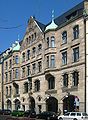
Borsighaus at Chausseestrasse 13
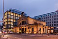
Suburban train station of the Szczecin train station in Julie-Wolfthorn-Straße


_-_geo.hlipp.de_-_38218.jpg)


Individual evidence
- ↑ Herbert Schwenk: Lexicon of Berlin Urban Development. Haude and Spener, Berlin 2002, p. 107.
- ^ Friedrich Leyden: Greater Berlin. Geography of the cosmopolitan city. Hirt, Breslau 1933 (therein: Development of the population in the historic districts of Old Berlin , p. 206).
Coordinates: 52 ° 32 ' N , 13 ° 23' E