
Rosenthaler Platz
| Rosenthaler Platz | |
|---|---|
|
|
|
 View towards east-northeast into Torstrasse (right) and Weinbergsweg (left) |
|
| Basic data | |
| place | Berlin |
| District | center |
| Created | 1910 |
| Confluent streets |
Rosenthaler Strasse , Torstrasse , Brunnenstrasse , Weinbergsweg |
| use | |
| User groups | Pedestrians , cyclists , road traffic , public transport |
| Technical specifications | |
| Square area | 40 × 25 meters |
The Rosenthaler Platz in Berlin 's Mitte district , the district center , forming a cross on which the Rosenthalerstraße that Brunnenstraße and Weinbergsweg the Torstraße meet, and is thus no place in the true sense. It is located at the point where the Rosenthaler Tor of the Berlin customs wall used to be, from which a street led towards the village of Rosenthal . Until the 19th century, this gate was one of the few through which Jews were allowed to enter Berlin. Those who were not allowed to enter could spend the night in a special Jewish hostel.
Immediately in front of the gate, at the behest of Friedrich II, the Rosenthaler Vorstadt was laid out, a colony in which Saxon guest workers were settled. The Rosenthaler Tor was demolished in the course of the expansion of Berlin and the razing of the customs wall around 1867.
In the published 1929 novel Berlin Alexanderplatz by Alfred Doblin Rosenthaler Platz plays the central role in the second book; The construction work on the subway between Alexanderplatz and Rosenthaler Platz also appears in it.
The Rosenthaler Platz underground station opened on April 18, 1930. When the construction of the Berlin Wall began on the night of August 13, 1961 , it was closed because the route led to West Berlin on both sides . Shortly after the reunification in the GDR , from December 22, 1989 to the summer of 1990, the station functioned as a provisional border crossing.
The Weinbergspark is located north of Rosenthaler Platz .
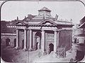
Rosenthaler Tor around 1860, behind it Brunnenstrasse

Place at Rosenthaler Tor, 1890

Heinrich-Heine-Buchhandlung on Rosenthaler Platz, 1976, directly in front of the then closed entrance to the underground station


Web links
- Otto Pniower: The former Rosenthaler Tor . In: Mitteilungen des Verein für die Geschichte Berlins , 44/1927, pp. 164–165 (see also illustrations on pp. 162, 163)
- Rosenthaler Platz. In: Street name lexicon of the Luisenstädtischer Bildungsverein (near Kaupert )
- Rosenthaler Platz on a website about the history of Brunnenstrasse
- Video on YouTube
Coordinates: 52 ° 31 ′ 48 ″ N , 13 ° 24 ′ 6 ″ E