
Rosenthaler suburb

I Alt-Berlin II Alt-Kölln (Spreeinsel) III Friedrichswerder IV Dorotheenstadt V Friedrichstadt XI Luisenstadt XII Neu-Kölln XIII Stralauer Vorstadt XIV Royal Town XV Spandauer Vorstadt XVI Rosenthaler Vorstadt XVII Oranienburger Vorstadt XVIII Friedrich-Wilhelm-Stadt Sources: Contents: Berlin address book, map base: District Office Mitte von Berlin

The Rosenthaler Vorstadt is a historic district that is now partly in the Berlin district of Mitte and extends beyond the district border into the districts of Prenzlauer Berg and Wedding .
geography
The Rosenthaler Vorstadt is bordered by Brunnenstrasse and ( Oranienburger Vorstadt ) in the west, the Berlin-Stettiner Eisenbahn and ( Gesundbrunnen ) in the northwest, the border with the Pankow district in the north, Prenzlauer Allee and ( Königsstadt ) in the east as well as Torstrasse and ( Spandauer Vorstadt ) in the south.
history
Explanation of the name
The first urban expansion in front of the Rosenthaler Tor, built in 1750, was called 'Voigtland' or 'Neu-Voigtland'. Only later did the name Rosenthaler Vorstadt prevail for the suburb that had developed before the Rosenthaler Tor and Schönhauser Tor. From 1994 to 2009 there was a redevelopment area of the same name, which only included parts of the Rosenthaler but also the Oranienburger suburb in the Mitte district. Since then, the name has been in use again, but mainly for the area of the former redevelopment area. Since 2007 there has also been a parking space management zone called Rosenthaler Vorstadt, which extends between Torstrasse , Schwedter Strasse / Choriner Strasse, Bernauer Strasse and Friedrichstrasse / Nordbahnhof .
17th-19th century
Until 1740, the area north of the Berlin city limits was undeveloped. Development was only possible after clearing had resulted in free areas. On September 22, 1751, King Friedrich II ordered foreign builders and their families to settle. Already on May 30th 1752 the settlement and the distribution of the land took place. In the 18th and 19th centuries, this district was also called New Voigtland after the origin of the craftsmen who settled there . The term “Das Voigtland” in Berlin was a synonym for the growing social problems in the period of early industrialization .
Of the original development with single-storey two-family houses, nothing has been preserved because of the building activity in the following centuries. However, the structure of the properties can still be seen today on the north-south streets (Brunnenstrasse, Bergstrasse, Ackerstrasse, Gartenstrasse). After the Rosenthaler Vorstadt had been incorporated into Berlin in 1829–1831, it was almost completely built on with typical Berlin tenements until the beginning of the First World War .
Since 1895, the Rosenthaler Vorstadt was the most populous district of Wilhelmine Berlin.
Since the 20th century

The Rosenthaler Vorstadt was a typical workers' residential area, which was also reflected in the corresponding election results.
In 1920, most of the Rosenthaler Vorstadt was incorporated into the Prenzlauer Berg district. The area north of Bernauer and west of Schwedter Strasse became part of the Wedding district. The area south of Bernauer Strasse and west of Schwedter and Choriner Strasse became part of the Mitte district.
A large part of the development in the Rosenthaler Vorstadt survived the Second World War . In the 1950s, numerous residential buildings were externally repaired and gaps in the war, such as on Weinbergsweg, were built with apartment blocks. In the 1980s, the area around Arkonaplatz was a showcase “reconstruction” area. The houses were completely modernized and almost all the rear buildings in the inner block areas were demolished - on the one hand for more open space and on the other hand to get more brightness into the apartments. On February 9, 1984, Erich Honecker inaugurated the GDR's two millionth apartment at Swinemünder Strasse 120. The greater part of the development in the Rosenthaler Vorstadt received little or no maintenance work.
For this reason, the redevelopment area of the same name was established in 1994 for a part of the Rosenthaler Vorstadt in the district of Mitte. Up until 2009, millions of government funds were used to renovate the buildings and improve the infrastructure, i.e. the situation with playgrounds, schools, kindergartens, street surfaces, etc.
population
Social classes
From the beginning, the Rosenthaler Vorstadt was predominantly a neighborhood for workers and the petty bourgeoisie. In times of economic crises, sometimes bitter poverty was rampant in parts of the population. Even after 1945 it is a rather simple residential area. That doesn't change until 1994. At the beginning of the renovation, the proportion of old people and students in the population is still high, due to the poor building fabric and numerous small apartments in the rear buildings. The renovation process resulted in an almost complete population exchange. The Rosenthaler Vorstadt is today a sought-after residential area because of its location close to the city center, but this is also reflected in high rents and purchase prices for condominiums. Whereas the average net income was 961 euros in 1994, it was 2747 euros in 2009.
Population development
| year | Residents |
|---|---|
| 1867 | 35,620 |
| 1871 | 46,244 |
| 1875 | 74,584 |
| 1880 | 113.453 |
| 1885 | 139,604 |
| 1890 | 175.865 |
| 1895 | 213,384 |
| 1900 | 253.149 |
| 1905 | 277.095 |
| 1910 | 309,551 |
| 1925 | 311.283 |
Economy, culture and sights
Former breweries
In the Rosenthaler Vorstadt as well as in the neighboring royal city a number of breweries were established in the middle of the 19th century. The former company premises with their historical buildings are today characterized by a mix of uses of culture, trade and commerce.
The most famous example of a conversion is the culture brewery on Sredzkistraße, with a supermarket, cinema, gastronomy and numerous cultural locations such as the Kesselhaus . A large office complex was built on the premises of the Königsstadt brewery. In the listed brewery buildings there is a cooperative that gives space to a wide variety of small businesses and projects. The Pfefferberg brewery today also has very different users: a hostel , gastronomy, a museum and a theater.
Museums
The Berlin Wall Memorial is located on Bernauer Strasse and encompasses the entire former wall strip from Schwedter Strasse to Gartenstrasse. This also includes the memorial complex on Ackerstrasse and the visitor center on the corner of the garden at Bernauer Strasse.
The architect Sergei Tchoban, together with Sergey Kuznetsov, has created a house for architectural drawings in Berlin, in which not only the internationally known collection of the Tchoban Foundation has found its home - the Museum for Architectural Drawings, Christinenstraße 18 on the grounds of the Pfefferbergbrauerei .
Special buildings
No longer existing buildings
In 1872 the orphanage of the Jewish community , built according to plans by Friedrich Hitzig , was opened at Weinbergsweg 14 . It was also called Reichenheim's orphanage after the founders Sara and Moritz Reichenhaim. It was destroyed in World War II.
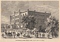
Reichenheim's orphanage, Weinbergsweg 14

Marthashof, school, Schwedter Strasse 37–40

Walhalla Theater, Weinbergsweg 20


Another building complex that served social purposes was Marthashof at Schwedter Strasse 37-40. The Emperor Diakonie 1854 founded the Marthashof, a Protestant hostel and educational institution for young maid. The complex, which consists of numerous individual school and residential buildings, was completely destroyed in the Second World War.
At Weinbergsweg 20 there was the Walhalla Theater from 1906 . From 1927 until its destruction in 1943, Carow's Lachbühne , the theater of the actor and entertainer Erich Carow, was located here .
Buildings under monument protection

Café in the Volkspark am Weinberg

Zionskirche , Zionskirchplatz

Former Jandorf department store , Brunnenstrasse 19–21

Primary school on Arkonaplatz


literature
- Rudolf Skoda : The Rosenthaler suburb. Housing conditions of urban poverty 1750–1850 , Berlin 1985 (no ISBN)
- City center Berlin e. V. (Ed.): Searching for traces in the Rosenthaler Vorstadt , Berlin 2003 (no ISBN)
- Senate Department for Urban Development (Ed.): The redevelopment of the Rosenthaler Vorstadt, 1994-2009, goals, processes, results, Berlin 2009 (no ISBN)
Web links
- Abolished redevelopment area Mitte - Rosenthaler Vorstadt . Senate Department for Urban Development
- Klaus Bädicker: Photographs of the Rosenthaler Vorstadt from the 1980s and 1990s
Individual evidence
- ↑ a b Development of the population in the historical districts of old Berlin. In: Friedrich Leyden: Greater Berlin. Geography of the cosmopolitan city . Hirt, Breslau 1933, p. 206.
- ↑ Election to the Berlin City Council in 1919
- ↑ Senate Department for Urban Development (ed.): The redevelopment of the Rosenthaler Vorstadt, 1994–2009, goals, processes, results, Berlin 2009, p. 30 f
- ↑ The Reichenheim Orphanage memorial plaque accessed on 23 September 2019
- ^ History of Marthashof, accessed on September 23, 2019
Coordinates: 52 ° 32 ' N , 13 ° 24' E