
Friedrichstadt (Berlin)

I Alt-Berlin II Alt-Kölln (Spreeinsel) III Friedrichswerder IV Dorotheenstadt V Friedrichstadt XI Luisenstadt XII Neu-Kölln XIII Stralauer Vorstadt XIV Royal Town XV Spandauer Vorstadt XVI Rosenthaler Vorstadt XVII Oranienburger Vorstadt XVIII Friedrich-Wilhelm-Stadt Sources: Contents: Berlin address book, map base: District Office Mitte von Berlin
The Friedrichstadt is a historical part of today partly in Berlin district of Mitte and extending beyond the county line in the district Kreuzberg extends. Friedrichstadt was an independent suburb of Berlin that was laid out in 1688 and incorporated in 1710. Friedrichstadt was named after the Prussian King Friedrich I.
geography

Friedrichstadt was created south of Dorotheenstadt and southwest of the suburb Friedrichswerder and thus also southwest of the two cities of Berlin and Kölln . Today the northern part of Friedrichstadt is in the Mitte district and the southern part in the Friedrichshain-Kreuzberg district . The border between the two districts runs along the southern side of Niederkirchnerstrasse and Zimmerstrasse.
The border of historical Friedrichstadt runs from Spittelmarkt to the north along Nieder- and Oberwallstraße, along Behrenstraße to the west to Ebertstraße, from here to the south via Potsdamer Platz , Stresemannstraße to Hallescher Tor and from here again to the north along the Lindenstrasse and Axel-Springer-Strasse back to Spittelmarkt. The Spittelmarkt and the Hausvogteiplatz belong historically as former bastions of the fortress to Neu-Kölln and Friedrichswerder .
history


City foundation by Friedrich I.
After the death of the Great Elector Friedrich Wilhelm in 1688, his son Elector Friedrich III, who later became King Friedrich I , had a new city built on the Köllnische Feldmark, which he named Friedrichstadt after his own name. First of all, a modern city emerged on paper, with a chessboard-like floor plan that provided a regular system of streets intersecting at right angles. The builders Michael Mathias Smids and Johann Arnold Nering were entrusted with the planning and construction management for the streets and houses until 1695, afterwards Johann Heinrich Behr and Martin Grünberg .
Friedrichstadt received city rights in 1691. After Friedrichswerder , Neu-Kölln and Dorotheenstadt, it was the fourth expansion of the historic city center of Berlin and Kölln. With effect from January 1, 1710, Friedrichstadt was united with the previously independent royal cities of Berlin, Kölln, Friedrichwerder and Dorotheenstadt to form one municipality. Until its expansion in 1732, Friedrichstadt extended westward to Mauerstraße, which was originally the inner passage of the Friedrichstadt fortification wall. To the south, Friedrichstadt extended to Zimmerstrasse.
An essential motive for founding Friedrichstadt was the principle of Prussian mercantilism "People are the greatest wealth". This was based on a tax policy, according to which the excise should cover a large part of the constantly increasing financial requirements for the army, court and bureaucracy with the emergence of absolutism in Prussia. The revenue of this indirect sales, gate, trade and cattle tax was related to the size of the population. The urgently sought-after increase in population was also achieved through the settlement of religious refugees, of whom the Huguenots from France in particular developed a formative influence in Friedrichstadt . They and other immigrants were granted extensive privileges when they settled in Friedrichstadt: commercial and long-term tax exemption, free building materials, subsidies for building costs and exemption from billeting. The condition was the quick completion of the houses, the plans of which were drawn up by the royal architects.
On June 1, 1701, the foundation stone for the French Huguenot Church in Friedrichstadt was laid, also as a symbol for freedom of belief in Brandenburg-Prussia, which was intended to attract further immigrants. On August 11, 1701, the foundation stone was laid for the German Church , which was intended to be used equally by the Reformed and Lutheran congregations. The Calvinists who had fled Switzerland and settled in Friedrichstadt belonged to the Reformed community . Both churches were located on an open area from which the Gendarmenmarkt later emerged.
Expansion by Friedrich Wilhelm I.


On May 23, 1721, Friedrich Wilhelm I issued the “patent relating to the benificia of those who want to rebuild on the Fridrichs = city”. Friedrich Wilhelm I, who initially neglected Friedrichstadt after his accession to the throne in 1713, now pushed for further expansion of Friedrichstadt. The still many "desert" (undeveloped) places should finally be filled by houses. In 1732, the Friedrichstadt project was brought to a conclusion within its initially planned limits: 1051 houses were inhabited or completed. The houses were austere and modest, sparse in decor, mostly two-story and always eaves , i.e. built with the long side and not the gable facing the street. The result was an overall picture with a high degree of regularity that corresponded to the absolutist ideas of the external design of a city.
In the same year the king decided to expand Friedrichstadt. The expansion affected the area west and south of the Wall Street and extended west to the same built Akzisemauer . The architectural management of the city expansion was the responsibility of the chief building director Philipp Gerlach and the court architect Johann Friedrich Jacob Grael. The expansion of Friedrichstadt was also planned on paper. The small-scale grid system of the already built-up area has now been replaced by a radial layout of the streets, which are bundled in one point, the roundabout (later Belle-Alliance-Platz , today: Mehringplatz ). The roundabout was one of three geometric squares that were created as part of the expansion of Friedrichstadt by Friedrich Wilhelm I: round the roundabout, octagonal the Octogon, later Leipziger Platz , and square the Quarré, the Pariser Platz (the squares were given their new names 1815, after defeating Napoleon ). Laurenz Demps suspects that they should symbolize the "squaring of the circle" and reflect the baroque zeitgeist, which "always assures itself of its own order and rule in geometric forms".
The expansion of Friedrichstadt went beyond the need for new house locations in Berlin and at that time no new settlers could be won. Therefore, Friedrich Wilhelm I went over to assigning generously defined building areas to important members of his state authorities, members of the court and high-ranking military personnel and encouraging them to build. This happened partly in the form of royal coercion with threat of punishment. In particular in Wilhelmstrasse named after Friedrich Wilhelm, stately aristocratic palaces for the Prussian elite with spacious garden areas were built during this period. For example, the Baron François-Mathieu de Vernezobre de Laurieux was urged by the king to build the most magnificent palace in Friedrichstadt, the Prinz-Albrecht-Palais in Wilhelmstrasse. This was the only way Vernezobre could buy his daughter free from the forced marriage arranged by the king with the captain of Forcade.
On January 1, 1729, a new market was opened between the German and French churches. From around 1710 on, the Gendarmenmarkt also had their quarters here, a cavalry regiment made up of French refugees, which was responsible for the later naming of the place in Gendarmenmarkt.
Friedrichstadt after the death of Friedrich Wilhelm I.


On the Gendarmenmarkt was in the years 1774 to 1776 on the orders of Friedrich II. The French comedy house built. The National Theater by Carl Gotthard Langhans was built in the same place between 1800 and 1801 . From 1780 to 1785, the German and French churches on the Gendarmenmarkt were each extended by a domed tower, the German Cathedral and the French Cathedral . The National Theater burned down to the outer walls in 1817. As a replacement, Karl Friedrich Schinkel designed the Royal Theater , which opened on February 10, 1821.
The first column monument in Berlin is located on Mehringplatz, the Peace Column, which was unveiled on August 3, 1843, after 25 years of peace in Prussia . After 1871 , Friedrichstrasse , named after King Friedrich I. , developed into the first business and entertainment street as well as the main traffic artery in the city of Berlin. Numerous imperial authorities took their seat in Wilhelmstrasse from 1871 onwards . The street developed into the center of German power, the German Empire , the Weimar Republic and during the time of National Socialism . The Reich Chancellery and the New Reich Chancellery were located here . Today the buildings of the former Reich Ministry for Public Enlightenment and Propaganda and the Reich Aviation Ministry , which are used by the Federal Ministry of Labor and Social Affairs and the Federal Ministry of Finance , are still here. At Leipziger Platz , construction began on the Wertheim department store in 1896 , which was then the largest department store in Europe. The Berlin banking district developed around Behrenstrasse and the Berlin newspaper district around Kochstrasse . Friedrichstadt achieved its highest population with 76,359 in 1871.

The writer Max Osborn gives a little insight into the 1870s in a memory report:
“[...] But the focus of business life was moved to Friedrichstadt, which until then [...] only had scattered shops and offices. The linden trees slowly filled in the gaps that had remained open between the individual shops of the decades before, and Leipziger Strasse rose to the historical role it has maintained to this day. [...]
However, as future-oriented as Leipziger Strasse began to develop - its image differed significantly from the image we have today of a main shopping street. No talk of the shops lined up in a closed row. There were long interruptions. The residential character of the street was not given up, on the upper floors there were still many middle-class families who felt quite comfortable. The gardens in the back of the houses had been preserved in large numbers, mostly turned into tavern gardens. The pleasant restaurants in the 'Königsgarten' and 'Leipziger Garten' […] held their own for the longest time, where people would sit under tall old trees on summer evenings for years to come.
The traffic on the sidewalks still took place in forms that we no longer know about today. People didn't just go to Leipziger Strasse to shop or at least to take a leisurely stroll. [...] The conquest of Leipziger Strasse took place in stages. Their eastern part was already occupied by the troops of the advancing merchants when it still looked quiet to the west. "
Friedrichstadt in Greater Berlin
When Greater Berlin was formed in 1920, Friedrichstadt was merged into the newly formed districts of Mitte and Kreuzberg . These two districts were not subdivided into districts.

The baroque Friedrichstadt was badly damaged during the Second World War . Many of the historic buildings were so badly damaged that they could only be removed. The construction of the Berlin Wall across the historic Friedrichstadt area brought further destruction. All remaining buildings in the area of the wall were demolished. The Checkpoint Charlie border crossing point was on the corner of Friedrichstrasse and Zimmerstrasse, and in October 1961 the scene of a dramatic confrontation between Soviet and US tanks.
Systematic reconstruction began in 1970 in the northern half of Friedrichstadt in the Mitte district, then East Berlin . In Leipziger Strasse , which was almost completely destroyed, mainly high-rise buildings with apartments were built. In the southern half, in the Kreuzberg district, then West Berlin , a plan for a demonstration area in southern Friedrichstadt was drawn up in the 1980s in connection with the preparations for the 1984 International Building Exhibition . This plan has been partially implemented. Taking into account the historical block structure, the vacant lots were filled according to the concept of Josef Paul Kleihues . After German reunification , numerous elegant and luxurious shops and office buildings were built in Friedrichstadt. In February 1996, the Galeries Lafayette department store opened at the corner of Friedrichstrasse and Französische Strasse as part of the Friedrichstadt-Passagen, which was built between 1993 and 1996 . The closure of all vacant lots on the former strip of the wall at Checkpoint Charlie and on Zimmerstrasse has not yet been completed. Colloquially today only the part of Friedrichstadt located in the middle is called Friedrichstadt . The Kreuzberg part of Friedrichstadt was formally designated as a redevelopment area in 2011 under the term Südliche Friedrichstadt .
politics

coat of arms
The coat of arms of Friedrichstadt shows a two-tone eagle. Left the red Brandenburg eagle and right the black Prussian eagle.
Federal government
There are many government buildings in the historical area of Friedrichstadt, especially in the Wilhelmstrasse area. Some of them were used by government agencies as early as the 19th century. To this day, however, new buildings have been added time and again. Both the oldest and most of the buildings built in the 20th and 21st centuries are among the sights of Berlin.
The Federal Ministries of Finance , for Economic Cooperation and Development , for Food, Agriculture and Consumer Protection , for Families, Seniors, Women and Youth , for Health and for Justice are located here .
State representations of the federal states at the federal level
The federal states of Bavaria , Brandenburg , Hamburg , Hesse , Mecklenburg-Western Pomerania , Lower Saxony , Rhineland-Palatinate , Saarland , Schleswig-Holstein and Thuringia have a state representative in the Friedrichstadt area .
Embassies
Numerous foreign representations are based in Friedrichstadt. The embassies of Belgium , Bulgaria , Brunei , Chile , Greece , Ireland , Canada , Kenya , the DPR Korea , Libya , Morocco , Myanmar , New Zealand , Portugal , Singapore , Slovenia , South Africa are located here and the Czech Republic as well as the Permanent Mission of Taiwan . Some embassies are housed in the same building.
Parties
Almost at the southern end of Friedrichstadt, the SPD has its federal party headquarters in the Willy Brandt House .
State of Berlin
The Berlin House of Representatives is the meeting place for the Berlin Parliament. It is located in the building of the former Prussian Landtag on Niederkirchnerstrasse. The Communist Party of Germany (KPD) was founded in the ballroom at the turn of the year 1918/19 . The Prussian State Assembly met here for the first time in 1919.

Federal Ministry of Justice , Mohrenstrasse 37 with Moorish colonnades

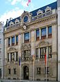
State Representation of Bavaria, Behrenstrasse 21/22
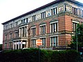
State representation Hamburg, Jägerstraße 2/3

Willy Brandt House , Wilhelmstrasse 140


Culture and sights
Museums
The German Cathedral with the exhibition "way - wrong turns - Detours" to the historical development of liberal parliamentary democracy and the French Cathedral with the Huguenot Museum are domed towers, 1785 built on two 1701-1708 churches, the German Church and the French Friedrichstadtkirche , were grown .
The Memorial to the Murdered Jews of Europe , or the Holocaust Memorial for short , is intended to serve as a memorial to the Jews murdered in the Holocaust under the tyranny of National Socialism . The monument was inaugurated on May 10, 2005. The approximately 19,000 m² area of the building is located in the north-western corner of Friedrichstadt, near the Brandenburg Gate . The “Information Center” under the field of stelae documents the persecution and extermination of European Jews in an exhibition.
At Checkpoint Charlie there is a panorama by the artist Yadegar Asisi, which illustrates the situation in divided Berlin in the 1980s, and the Wall Museum . Checkpoint Charlie was one of the most famous border crossings in divided Berlin between 1945 and 1990. The checkpoint was on Friedrichstrasse between Kochstrasse and Zimmerstrasse. It connected the American sector ( Kreuzberg district , West Berlin ) with the Soviet sector ( Mitte district , East Berlin ).
The Museum for Communication Berlin at Leipziger Straße 16 is one of four museums in Germany that are organisationally combined in the Museum Foundation for Post and Telecommunications . The Berlin Museum sees itself as a place of encounter, exchange and entertainment. In its treasure chamber, the museum presents valuable exhibits, above all the Red and Blue Mauritius .
The Martin-Gropius-Bau , the former arts and crafts museum , is an exhibition house at Niederkirchnerstraße 7, which houses large temporary exhibitions. Until 1990 the building was located directly on the Berlin Wall .
The Topography of Terror is a project to document the National Socialist terror with a temporary permanent exhibition on the site of the former Prinz-Albrecht-Straße 8, today: Niederkirchnerstraße 8. There, in the former arts and crafts school, was the headquarters of the Secret State Police (Gestapo ). In the immediate vicinity was the Prinz-Albrecht-Palais , where the headquarters of the Security Service (SD) of the SS and the Reich Security Main Office (RSHA) were located.

German Cathedral, Gendarmenmarkt

Konzerthaus Berlin, Gendarmenmarkt

checkpoint Charlie

Museum for Communication Berlin
Martin-Gropius-Bau


Theaters and venues
The Konzerthaus Berlin is located on Gendarmenmarkt . The small French Comedy House was built here in 1774–1776 and replaced in 1800 by a new building, the theater. The theater was destroyed twice and rebuilt as a concert hall. The concert hall now has 1,850 seats.
E-Werks is located at Mauerstraße 80. It made a name for itself as a techno club in the 1990s and is now an event location.
Special buildings

The Gendarmenmarkt is one of the most beautiful squares in Europe. The concert hall is located on the square, framed by the German and French Cathedral. In the 1990s, the Gendarmenmarkt was surrounded by several new buildings. The oldest building on Gendarmenmarkt is the former Prussian State Bank (built in 1901) on Jägerstrasse. The Friedrichstadt Passagen is right next to the famous square . The name refers to the shopping arcade that connects the three “quarters” in the basement. The northern “quarter” is the Galeries Lafayette department store . The adjoining “Quarters” 205 and 206 to the south house shops on the lower floors and offices above.
Others
On the Bethlehemkirchplatz, which is at the intersection of Mauerstraße and Krausenstraße, you can see the floor plan of the former Bethlehem Church . There is also the huge sculpture "House Ball" by Claes Oldenburg and Coosje van Bruggen .
Sons and daughters of Friedrichstadt
- Heinrich Eduard Jacob (1889–1967), journalist and writer
literature
- Wolfgang Schneider : Berlin. Gustav Kiepenheuer Verlag, Leipzig and Weimar 1983.
- Roland Bauer: Berlin, Volume 1, Illustrated Chronicle to 1870. Dietz Verlag Berlin, Berlin 1988, ISBN 3-320-00831-5 .
- Herbert Schwenk: Berlin Urban Development from A to Z. Edition Luisenstadt, Berlin 1998, ISBN 3-89542-100-6 .
- Laurenz Demps : Berlin-Wilhelmstrasse. A topography of Prussian-German power . 4th edition, Ch. Links Verlag, 2000, ISBN 978-3-86153-597-3 .
- Laurenz Demps: The Gensd'armen Market. Face and history of a Berliner Platz. Henschelverlag, Berlin 1987.
- Renovation newspaper Südliche Friedrichstadt. Asum GmbH, Berlin since 2014, urn : nbn: de: kobv: 109-1-7827819 (archive)
- Werner Hegemann : The stone Berlin. Ullstein, Berlin 1930.
Web links
Individual evidence
- ^ Werner Hegemann: The stone Berlin . Ullstein, Berlin 1930, p. 59 .
- ↑ Laurenz Demps: The Gensd'armen market. Face and history of a Berliner Platz . Henschelverlag, Berlin 1987, p. 23-24 .
- ↑ Laurenz Demps : The Gensd'armen market. Face and history of a Berliner Platz . Henschelverlag, Berlin 1987, p. 22-28 .
- ↑ a b Gerhard Fischer: The Huguenots in Berlin . Hentrich & Hentrich, Berlin 2010, p. 27 .
- ^ A b Johann Marius Friedrich Schmidt: Historical Atlas of Berlin in VI ground plans based on the same measure from 1415 to 1800 . Schropp, Berlin 1835, p. 4 .
- ↑ Laurenz Demps: The Gensd'armen market. Face and history of a Berliner Platz . Henschelverlag, Berlin 1987, p. 28 .
- ↑ Laurenz Demps: The Gensd'armen market. Face and history of a Berliner Platz . Henschelverlag, Berlin 1987, p. 77 .
- ↑ Laurenz Demps: The Gensd'armen market. Face and history of a Berliner Platz . Henschelverlag, Berlin 1987, p. 77-81 .
- ^ Albert Behr, Alfred Hoffmann: The theater in Berlin . Ed .: Erhardt Gißke. Verlag für Bauwesen, Berlin 1984, p. 11 .
- ↑ a b Laurenz Demps: The Gensd'armen market. Face and history of a Berliner Platz . Henschelverlag, Berlin 1987, p. 65-67 .
- ^ Laurenz Demps: Berlin-Wilhelmstrasse. A topography of Prussian-German power . 4th edition. Ch. Links Verlag, Berlin 2010, p. 22 .
- ^ A b Laurenz Demps: Berlin-Wilhelmstrasse. A topography of Prussian-German power . 4th edition. Ch.links, Berlin 2010, p. 23 .
- ↑ Laurenz: The Gensd'armen market. Face and history of a Berliner Platz . Henschelverlag, Berlin 1987, p. 95-99 .
- ^ Johann Marius Friedrich Schmidt: Historical atlas of Berlin in VI ground plans according to the same measure from 1415 to 1800 . Schropp, Berlin 1835, p. 5 .
- ^ A b c Laurenz Demps: Berlin-Wilhelmstrasse. A topography of Prussian-German power . 4th edition. Ch. Links Verlag, Berlin 2010, p. 23-28 .
- ↑ Laurenz Demps: The Gensd'armen market. Face and history of a Berliner Platz . Henschelverlag, Berlin 1987, p. 88 .
- ^ Laurenz Demps: Berlin-Wilhelmstrasse. A topography of Prussian-German power . 4th edition. Ch. Links Verlag, Berlin 2010, p. 31-33 .
- ^ Werner Hegemann: The stone Berlin . Ullstein, Berlin 1930, p. 100 .
- ↑ Laurenz Demps: The Gensd'armen market. Face and history of a Berliner Platz . Henschelverlag, Berlin 1987, p. 111 .
- ^ Albert Behr, Alfred Hoffmann: The theater in Berlin . Ed .: Erhardt Gißke. Verlag für Bauwesen, Berlin 1984, p. 29-37 .
- ^ Albert Behr, Alfred Hoffmann: The theater in Berlin . Ed .: Erhardt Gißke. Verlag für Bauwesen, Berlin 1974, p. 92 .
- ^ Laurenz Demps: Berlin-Wilhelmstrasse. A topography of Prussian-German power . 4th edition. Ch. Links Verlag, Berlin 2010, p. 7 .
- ^ Friedrich Leyden: Greater Berlin. Geography of the cosmopolitan city . Hirt, Breslau 1933 (therein: Development of the population in the historic districts of Old Berlin , p. 206)
Coordinates: 52 ° 30 ′ 46 ″ N , 13 ° 23 ′ 34 ″ E