
Neu-Kölln

I Alt-Berlin II Alt-Kölln (Spreeinsel) III Friedrichswerder IV Dorotheenstadt V Friedrichstadt XI Luisenstadt XII Neu-Kölln XIII Stralauer Vorstadt XIV Royal City XV Spandauer Vorstadt XVI Rosenthaler Vorstadt XVII Oranienburger Vorstadt XVIII
Friedrich-Wilhelm-Stadt
Sources:
Contents: Berlin address book,
map basis: District Office in the center of Berlin


Neu-Kölln (different spelling variants also with “C”, at times with the addition “on the water”) is a historic district in what is now Berlin 's Mitte district . Created in 1662 as an extension of Kölln , it was initially a district of Kölln and later a separate district and is therefore called Neu-Kölln. It is not identical to the district of Berlin-Neukölln further south-east .
geography
Neu-Kölln is located south of the Spree Canal. The southern border is formed by the fortress moat (Grüner Graben), which was filled in in 1883, which can still be seen in part from the course of the property boundaries. Neu-Kölln is bordered by Luisenstadt in the south and Friedrichswerder in the west .
There are connections to the Alt-Kölln district to the north via the Old and New Gertrauden Bridge , the Grünstraßen and Roßstraße Bridge and the Inselbrücke . Until it was demolished in 1960, the Waisenbrücke was also connected to old Berlin.
history
Explanation of the name
As a city extension of Kölln , the quarter and later district received its name Neu-Kölln . Further spellings are: Neu-Cölln , Neucölln , Neukölln and at times with the addition of am Wasser .
1662-1945
In 1662 the medieval core cities Berlin and Kölln were expanded for the first time; in the south, beyond the Spreearm , around the 19 hectare suburb of Neu-Kölln , in the west, also on the other side of the Spreearm, around the 26 hectare Friedrichswerder . The relatively small Neu-Kölln never received the status of a city, but was built as a district of Kölln. The now three cities, Berlin, Kölln and Friedrichswerder were surrounded by the Memhardt fortifications between 1658 and 1683 , according to plans and under the supervision of Memhardt , then Nering .
Neu-Kölln initially only had two streets running from northeast to southwest: Street Neukölln am Wasser (today Märkisches Ufer ) and Street Neukölln am Wall (today: Wallstraße ). Its eastern part was initially called Siropsgasse after the Splitgerber's sugar refinery located there at the time , which stretched between Bastion IV (today: Spittelmarkt ) and Bastion VII (today: Köllnischer Park ). The Neue Roßstrasse running from northwest to southeast , the extended Roßstrasse in Alt-Kölln, led to the Köpenicker Tor and the arterial roads to Köpenick and Dresden . In 1740 the Neue Grünstrasse was added. In 1800 the Great National Mother Lodge "To the Three Worlds" moved into its new domicile in Splittgerbergasse. The property was located on the site of the former bastions VI and VII. Since the middle of the 19th century, there has been an extension of the street An der Fischerbrücke and Inselstraße, an extension of the street from Mühlendamm to Köpenicker Straße .
_in_Handbuch_der_Leistungsf%C3%A4higkeit_der_gesammten_Industrie_Deutschlands_(1873).png)
In the 19th century, large commercial buildings were built on Wallstrasse, such as the headquarters of Ravené or Spindlershof, and since 1868 the Kölln high school had its own house in temporary quarters on the corner of Inselstrasse after years. In 1873 the Köllniche Park was laid out at the northeast end of Neu-Kölln , in which the Märkisches Museum was built from 1901 to 1907 according to plans by Ludwig Hoffmann . The U-Bahn line A (today: Line U 2 ), which was extended in 1913 from the Spittelmarkt underground station to the Nordring underground station (today: Schönhauser Allee ), received a station in Neu-Kölln, the Inselbrücke underground station (today the Märkisches Museum) .
In the Second World War , Neu-Kölln was not as badly destroyed as the part of Luisenstadt immediately to the south. Nevertheless, the Kölln High School lost two thirds of its school building and the entire north wing of the Märkisches Museum was lost.
1945 until today
At the end of the 1960s, a so-called traditional island was built on the Märkischer Ufer , where gaps in the war were filled with reconstructions of houses that had been demolished elsewhere. So the Ermelerhaus from the Breiten Straße 11 and the community center Friedrichsgracht 15 came to the Märkische Ufer. In the mid-1960s, two schools with gyms were built on the grounds of the “To the Three Worlds” box.
Since the 1980s, there have been two residential buildings on Wallstrasse, which are unusual for GDR standards : on the one hand, a prefabricated building with a "round corner" on Spittelmarkt and , on the other hand, a traditionally built masonry, very differentiated building on Grünstraßenbrücke. Walter Womacka had his studio in the latter . After 1990 most of the war gaps were rebuilt.

Märkisches Museum

Fragment of the school building of the former Köllnisches Gymnasium

Märkisches Museum underground station, formerly Inselbrücke
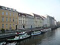
The traditional island of Märkisches Ufer


Culture
Museums
The Märkisches Museum in Neu-Kölln has existed since 1907. Today the museum belongs to the Stiftung Stadtmuseum Berlin and is one of a total of five museum locations. A general renovation of the former main building and an expansion to include the neighboring naval building are planned in the coming years.
The Berlin-Brandenburgische Schifffahrtsgesellschaft e. V. the historic port . There is an exhibition ship and tours with historical ships several times a year.
Historic buildings
There are 27 individual monuments in Neu-Kölln and there are also monument ensembles and an overall complex.
literature
- City expansion . In: Horst Ulrich and Uwe Prell (editors): Berlin manual. The lexicon of the federal capital. FAB Verlag, Berlin, 1992, ISBN 3-927551-27-9 , pp. 1128–1134, here: p. 1128, with references.
- Description of the royal royal cities of Berlin and Potsdam , Volume I, 1786, pp. 133–140.
- Berlin, depicted historically and topographically , 1848, pp. 171–175.
Individual evidence
Coordinates: 52 ° 31 ' N , 13 ° 25' E