
Traditional island
Traditional island is a term used in the preservation of monuments and describes the selective historical reconstruction of individual urban ensembles or squares after the extensive destruction of the Second World War in Braunschweig .
history
prehistory

Until the beginning of the Second World War, the urban landscape , which had grown over centuries since the Middle Ages, with its partly organically created streets and buildings from various eras and architectural styles, had largely been preserved. Braunschweig was, especially in the city center, a city characterized by hundreds of half - timbered houses when the destruction by Allied air raids began in the summer of 1941. The first air raid was carried out on August 17, 1940 by the Royal Air Force (RAF). From January 27, 1943, bombers of the United States Army Air Forces (USAAF) attacked German cities even during the day. From February 1944 ( Big Week ), the industrial, research and armaments location Braunschweig was a planned target for American and British bomber squadrons. By the end of the war there had been around 42 air raids by Allied bomber units. The most devastating attack took place on the night of October 15, 1944 by No. 5 RAF Bomber Group . The resulting two and a half day firestorm destroyed 90% of the city center. The last bombing raid on the city took place on March 31, 1945 by the 392nd US Bomber Group.
The concept of the "traditional islands"
In view of the large-scale destruction, the then state curator and chief monument protector of the state of Braunschweig, Kurt Seeleke, designed the concept of the “traditional island” together with the architect Friedrich Wilhelm Kraemer who worked in the city . His goal was to secure preserved historical buildings, especially around five inner-city churches in the five historical moorings of Braunschweig, Altewiek , Altstadt , Hagen , Neustadt and Sack .
The following are the five traditional islands, plus the more or less extensive surroundings depending on the preserved or rebuilt historical building fabric:
- Aegidienviertel , around the Aegidienkirche
- Old town market , around the Martinikirche
- Burgplatz , around the Brunswick Cathedral
- Magniviertel , around the Magnikirche
- Michaelisviertel , around the Michaeliskirche
Due to the irreparable destruction in the Weichbilden Neustadt around the Wollmarkt and the Andreas Church and in Hagen with the Hagenmarkt and the adjoining Katharinenkirche , these two areas had to be excluded as future traditional islands, as there - apart from the two badly damaged churches and the Liberei - none there were other preserved historical buildings. The area of the damaged Braunschweig castle on Bohlweg , whose row of houses opposite the castle was completely destroyed, was also excluded .
In 1963 the traditional islands were included in the monument preservation statute of the city of Braunschweig, which gave them legal protection.
Although most of the buildings around the Kohlmarkt, which is not far from the old town market, survived the war largely undamaged, this area is not one of the traditional islands.
criticism
Critics of the concept led u. a. indicated that it was a kind of " open-air museum ", as even these "islands" had war-related gaps, which in turn were closed with buildings that had to be dismantled at their original locations (e.g. the Rüninger customs house ), in order to then fit them into one of the traditional islands. Another point of criticism was the apparent historical authenticity that was artificially and subsequently recreated, which, however, did not correspond to historical facts.
The primary purpose of the “island of tradition” concept was, as Göderitz put it, “to give future generations a picture of the old Braunschweig [which was lost in the bombing].” Göderitz's understanding was to use architecture as a means of illustrating the history of urban development ; these stone - but not mute - witnesses should contribute to this. Kurt Seeleke had already designed the concept in its basic features in 1943 (after the first bombing raids on Braunschweig) and further developed it in collaboration with Kraemer until 1955. Seeleke was a constant and harsh critic of what he found to be anonymous or inconsequential “architectural pulp” which found its way into the destroyed German cities as reconstruction and in which these “historical reserves ” were distributed “scattered like raisins” .
Wilhelm Westecker, a critic of the “Traditionsinsel”, said: “The history of the early days and the building history of centuries are still very impressively reflected in the Burghof [= Burgplatz]. Only in 1945 the crown of the old city was degraded to an isolated open-air museum. "
The passionate discussions about the reconstruction of ensembles were repeated later in similar projects, such as the New Frankfurt Old Town or the Old Market in Potsdam .
.JPG)


.JPG)
.JPG)
literature
- Udo Gebauhr: Traditional islands . In. Luitgard Camerer , Manfred Garzmann , Wolf-Dieter Schuegraf (eds.): Braunschweiger Stadtlexikon . Joh. Heinr. Meyer Verlag, Braunschweig 1992, ISBN 3-926701-14-5 , p. 230 .
- Johannes Göderitz : Braunschweig. Destruction and construction. In: Municipal Political Writings of the City of Braunschweig. Issue 4, May 1949.
- Kurt Seeleke : The reconstruction of the old town of Brunswick. In: Preserve and design. Hamburg 1962, pp. 115-118.
Individual evidence
- ^ Johannes Göderitz: Braunschweig. Destruction and construction. P. 33.
- ^ Eckart Grote: Target Brunswick 1943–1945. Air raid target Braunschweig - documents of destruction. Braunschweig 1994, p. 11.
- ↑ Werner Girbig: 1000 days over Germany. The 8th American Air Force in World War II. Munich 1964, p. 198 ff.
- ↑ Rudolf Prescher : The red rooster over Braunschweig. Air raid protection measures and aerial warfare in the city of Braunschweig 1927 to 1945 , Braunschweig 1955, p. 111.
- ↑ Braunschweiger Zeitung (ed.): The bomb night. The air war 60 years ago. Braunschweig 2004, p. 8.
- ^ Eckart Grote: Target Brunswick 1943–1945. Air raid target Braunschweig - documents of destruction. Braunschweig 1994. p. 151.
- ↑ Bernd Wedemeyer: The former residential palace in Braunschweig. Documentation about the building and its demolition in 1960. 2nd edition. Braunschweig 1993, p. 155.
- ↑ Gudrun Fiedler : No more country and yet region. In: Horst-Rüdiger Jarck , Gerhard Schildt (ed.): The Braunschweigische Landesgeschichte. A region looking back over the millennia . 2nd Edition. Appelhans Verlag, Braunschweig 2001, ISBN 3-930292-28-9 , pp. 1141 .
- ↑ Gudrun Fiedler: No more country and yet region. P. 1142.
- ↑ Friedrich Mielke : The future of the past. Principles, problems, and possibilities of monument preservation. DVA, Stuttgart 1975, ISBN 3-421-02456-1 , p. 140.
- ↑ quoted from: Uwe Beitz: Zur Zierde der Stadt. Building history of the Braunschweig Burgplatz since 1750. Friedrich Vieweg & Sohn, Braunschweig / Wiesbaden 1989, ISBN 3-528-08732-3 , p. 150.
Remarks
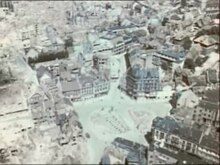
- ↑ In raking light (sun is in the West) easily recognizable: The (bright, wide) road from the bottom, obliquely running right is the Fallersleber road , which in the Hagenmarkt flows. The badly damaged Katharinenkirche is clearly visible . Following the Hagenmarkt to the right, completely destroyed areas of the city center . The three streets branching off from Fallersleber Strasse (with large-scale bombs) in the direction of Steinweg are v. l. To the right : Mauernstrasse , Schöppenstedter Strasse and Wilhelmstrasse . The Steinweg runs towards Burgplatz . The State Ministry can be seen here in Dankwardstrasse, opposite the City Hall . Dankwarderode Castle and the cathedral are visible on Burgplatz . The heavily damaged Braunschweig Castle on Bohlweg is slightly above the center of the picture . Behind it, to the south, destroyed streets around the Aegidienkirche , including Aegidienmarkt , Kuhstraße , Stobenstraße and Auguststraße . The old train station can be seen in the upper right corner. On the left edge of the picture, the State Theater is visible in the middle , and a little above the Herzog Anton Ulrich Museum . In the upper left corner is the Magniviertel with numerous destroyed and damaged buildings. For example: the badly damaged Magni Church and large areas of destroyed streets around the Ackerhof . The municipal museum , the Löwenwall and the Gauss School can also be seen .
-
↑ the first flight route from north to south : Andreas cemetery , Hamburger Straße , Gaußbrücke , Bammelsburg , Löbbeckes Island , Island Wall , Rehn romp bunker , Nickelnkulk , Kaiserstraße , wool market , St. Andrew's Church , Liberei , Kröppelstraße , Old scales , Long Street , New Town Hall , Packhof , Meinhardshof , brethren , Kannengießer road , Schuhstraße , coal market , home to the sun , home to Rose , house of the Golden star , goat market , banking center , Oberpostdirektion , Friedrich-Wilhelm-Platz
second flight route from east to south : water tower on the Giersberg , Park street , Museum park , Herzog Anton Ulrich-Museum , Magniviertel , Magnikirche , Municipal Museum , Gaußschule , Bunker Ritterstraße , Ackerhof , Ölschlägern , Klint , Kuhstraße , Auguststraße , Aegidienmarkt , Aegidienkirche , Aegidienkloster , Garrison School , Lessingplatz