Farm
| Farm | |
|---|---|
| Street in Braunschweig | |
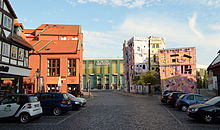
| V. l. to the right: Ackerhof 1, Volksfreund-Haus, Ackerhof 2. | |
| Basic data | |
| place | Braunschweig |
| District | Magniviertel |
| Created | 13th Century |
| Hist. Names | sign |
| Connecting roads | Schlossstrasse |
| Cross streets | Georg-Eckert-Strasse, Ölschlägern, Magnikirchstrasse, Langedammstrasse |
| Buildings |
Ackerhof 2 , Ackerhof-Portal , Volksfreund-Haus , Happy RIZZI House |
| use | |
| User groups | Pedestrian traffic , bicycle traffic , car traffic |

The Ackerhof is a small square with an attached street of the same name in the Magniviertel of Braunschweig . Its origin is in the 13th century. The streets Ölschlägern , Langedammstraße , Schloßstraße and Magnikirchstraße flow into the square . The Friesenstrasse also led to the Ackerhof. This only changed in the early 1970s when Georg-Eckert-Strasse was laid out, which cut through the old course of Friesenstrasse.
history
The Magniviertel is part of the precincts of Altewiek and one of the oldest settlement areas of the city of Braunschweig. During excavation work for an underground car park in the Horten department store being built on Bohlweg in 1972 , archaeologists came across numerous artifacts , including broken pieces and a wooden well. In particular, the sherds found could be dated to the early pre-Christian times. The fountain was dated to the 10th century. This shows that the area was settled very early.
In the old days, two long-distance trade routes ran through the Altewiek , of which the northern one , coming through the Magnitor and past the Magnikirchhof, led to the Ackerhof, which thus had an important distribution function. In the 13th century, the wider area surrounding what includes the Ackerhof today was originally part of a larger ducal property that stretched from today's Friesenstraße to Langedammstraße and the (then existing) Stobenbrücke. In 1254 Duke Albrecht made it a gift to the Marienspital ( Allod ). At that time, the entire area was known as “alodium hospitalis” (1295) and finally in 1572 as “our leven fruwen ackerhof”. In the 18th century, the Ackerhof was located on the south-eastern rear of the first Braunschweig palace , designed by the baroque master builder Hermann Korb , which was partially redesigned by master builder Peter Joseph Krahe during the time of the French occupation of Braunschweig . A preserved stone archway (which was stored in the municipal building yard in 1971 ) led to the ducal stables , the page house, the riding school and the carriage shed on the farmyard.
Naming through the centuries
The original name of the small square into which the streets of Ölschlägern and Langedammstraße converged was “Schild”. A name that was often chosen for places where converging streets met at an obtuse angle , creating a square. "Schild" or "uppe dem Schilde" has been documented as a designation since 1427. In the following centuries the name changed more often: Around 1553 the square seems to have been called "Z [i] egenmarkt". In the city maps of 1671 and 1758 it is recorded as "on the shield". In the Braunschweig address book from 1813 as “Schild in der Altenwick”, between 1816 and 1840 as “on” or “in front of the Ackerhofe”, in 1850 again as “on the Schilde” and occasionally as “behind the Ackerhofe (shield)”. The square was finally given its current name in 1858. The name "Ackerhof" originally referred to a plot of land beginning a little north of it, which belonged to the ducal court administration and extended to the Stobenbrücke. Around 1758 this property in its old dimensions was still referred to on a city map as "Ackerhof", but already on a map from 1671 there was the reference to "Been Ackerhof".
Buildings around the Ackerhof
Ackerhof 2

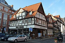
Since the area of the Ackerhof is comparatively small, there were only two house numbers until the end of the war: No. 1 is on the east side of the square and was a two-story commercial building before the Second World War. This was badly damaged by bombs. In 1946 a one-story building was erected in which the "Ludwig Ohlendorf" company, founded in 1892, is located. On the west side of the square is Ackerhof 2 , the oldest dated half-timbered house in Braunschweig, according to E. Arnold's extensive building history studies from 2004, however, he suspects that it is rather the oldest dated building in Northern Germany, probably even all of Germany. On the north side of the house, the year “Anno d [omi] ni m cccc xxxii” ( In the year of the Lord 1432 ) can be read as a Roman number . The building complex Ackerhof 2 also includes other buildings on Langedammstrasse.
People's friend house
On the southwest side of the Ackerhof (Ölschlägern 29, corner of Schlossstrasse 8) is the so-called “ Volksfreund-Haus ” of the SPD , built in 1913 by the architects Karl Munte and JM Kerlé . It was created after a road breakthrough from Ackerhof to today's Ritterstraße was made in 1905 . This new street was named "Schlossstrasse". In the place of today's Volksfreund-Haus there was a multi-storey half-timbered house, which is located in the immediate vicinity of the Magni Church "Behind the Magni Church" T. was rebuilt.
The Volksfreund-Haus of the SPD, which also served as the editorial building for the SPD party newspaper " Braunschweiger Volksfreund ", was stormed and devastated by members of the SS on March 9, 1933 , injuring numerous people and killing some. Party and union files as well as books, flags, etc. were burned publicly on the farm.
Ackerhof portal

The portal designed by Wilhelm von Gebhardi in 1772 as the northern entrance to the palace garden of the “ Grauen Hof ” was moved to the Ackerhof around 1800 and was located in its northwestern area, which ultimately gave it the name Ackerhof portal . The portal survived the Second World War largely undamaged, but was dismantled in the course of the reconstruction in the area of the castle ruins, which were demolished in 1960, mainly because of the new construction of Georg-Eckert-Strasse in 1971 and has been stored since then.
Further structural environment
Like other large parts of the Braunschweig city center , the Magniviertel and with it the area around Ackerhof up to Bohlweg was severely damaged or extensively destroyed by Allied bombing during the Second World War, especially that on Sunday, October 15, 1944 . As many of the buildings in the city center were made of half-timbered construction, most of them fell victim to the firestorm . In addition, several damaged buildings or ruins were demolished in the post-war period to make way for new buildings. The entire north side of Langedammstrasse, which had been completely destroyed in the war, was only rebuilt in the 1970s. The property opposite to the east (today Ackerhof 4) was not built on until the end of 1999. The Happy RIZZI House is located on it today .
Today the Ackerhof is a central location next to the square in front of the Magni Church during the Magnifesto , which has been taking place every year on the first weekend in September since 1974 .
The Ackerhof then and now
Figures starting clockwise from the west.
| Around 1900 | 2011 | annotation |
|---|---|---|
| The Ackerhof 2 – Langedammstrasse 11 building complex has been largely preserved in 2011. On the first floor, the two stores were turned into a store in the 1950s. | ||
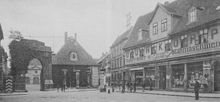
| The building Ackerhof 2 can just be seen on the left edge of the picture. The building on the north side of Langedammstrasse was destroyed in the war, the portal dismantled and stored in 1971. The building to the right was destroyed. The Friesenstraße was renamed Ackerhof at this point when it was cut in the early 1970s. The Ackerhof 1 building still exists today in a different form after war damage. | ||
| The portal dismantled and stored in 1971. The building to the right was destroyed. The Happy RIZZI House has been located there since 1999. The Friesenstraße was renamed Ackerhof at this point when it was cut in the early 1970s. The Ackerhof 1 building still exists today in a different form after war damage. | ||
| The buildings on the left and right (Ackerhof 1) of Magnikirchstrasse have been changed. War damage to the church was removed. | ||
| The half-timbered house at Ölschlägern 29, at the corner of Schlossstrasse 8, was dismantled around 1913 and partially rebuilt at its current location “Hinter der Magnikirche 1”. The “Volksfreund-Haus” is located at the original location today. Ackerhof 2 can be seen on the right edge of the picture. |
literature
- City of Braunschweig, Elmar Arnhold, architects' office Schmidt S&P: Braunschweig - Ackerhof 2: Building historical investigation (excerpt), Braunschweig 2004
- Jürgen Hodemacher : Braunschweigs streets - their names and their stories, Volume 1: Innenstadt , Cremlingen 1995, ISBN 3-92706-011-9
- Wolfgang Kimpflinger: Monument topography Federal Republic of Germany . Architectural monuments in Lower Saxony , Volume 1.1 .: City of Braunschweig , Part 1, Hameln 1993, ISBN 3-87585-252-4
- Heinrich Meier : The street names of the city of Braunschweig , in: Sources and research on Braunschweigischen history , Volume 1, Wolfenbüttel 1904
Web links
Individual evidence
- ↑ a b c d Heinrich Meier: The street names of the city of Braunschweig , p. 11
- ↑ a b c Heinrich Meier: The street names of the city of Braunschweig , p. 10
- ^ A b Jürgen Hodemacher: Braunschweigs streets - their names and their stories, Volume 1: Innenstadt , p. 9
- ^ Richard Moderhack : Braunschweigs Stadtgeschichte , In: Gerd Spies (Ed.): Braunschweig - The image of the city in 900 years. History and views , Volume I, 2nd edition, Braunschweig 1985, p. 3
- ↑ Wolfgang Kimpflinger: Monument topography Federal Republic of Germany. Monuments in Lower Saxony , Volume 1.1 .: City of Braunschweig , Part 1, p. 138
- ↑ a b Paul Jonas Meier and Karl Steinacker : The architectural and art monuments of the city of Braunschweig , 2. Erw. Edition, Braunschweig 1926, p. 80
- ↑ a b City of Braunschweig, Elmar Arnhold, architects' office Schmidt S&P: Braunschweig - Ackerhof 2: Building historical investigation (excerpt), Braunschweig 2004, p. 2
- ^ History of the company Ohlendorf ( Memento from September 14, 2012 in the web archive archive.today )
- ↑ Andrea Boockmann: DI 35 No. 104 . urn : nbn: de: 0238-di035g005k0010408 ( inschriften.net ).
- ↑ Wolfgang Kimpflinger: Monument topography Federal Republic of Germany. Monuments in Lower Saxony , Volume 1.1 .: City of Braunschweig , Part 1, p. 152
- ↑ Anja Hesse: Networked Memory: Topography of National Socialist Rule in Braunschweig 1930 to 1945 , Appelhans 2003, p. 18
- ↑ Photo of the files and books being burned on the farm
- ↑ Dieter Diestelmann: Braunschweig - A lost cityscape , Gudensberg-Gleichen 1993, ISBN 3-86134-111-5 , p. 63
- ↑ Norman-Mathias Pingel, In: Garzmann, Schuegraf, Pingel (Ed.): Braunschweiger Stadtlexikon - supplementary volume , Braunschweig 1996, ISBN 3-926701-30-7 , p. 15
- ↑ Rudolf Prescher : The red rooster over Braunschweig. Air raid protection measures and aerial warfare events in the city of Braunschweig 1927 to 1945 , Braunschweig 1955, p. 112
Coordinates: 52 ° 15 ′ 43.5 ″ N , 10 ° 31 ′ 43.5 ″ E


