
Bohlweg
| Bohlweg | |
|---|---|
|
|
|
 |
|
| Bohlweg, looking north towards the Katharinenkirche | |
| Basic data | |
| place | Braunschweig |
| District | Downtown |
| Connecting roads | north: Hagenmarkt , An der Katharinenkirche; south: Waisenhausdamm, Stobenstrasse |
| Cross streets | Hagenscharrn , Wilhelmsgarten (within walking distance), Dankwardstraße, Steinweg, Langer Hof (west. Spange), Ritterbrunnen (east. Spange), Schlosspassage, Georg-Eckert-Strasse, Damm |
| Places | Place at the Ritterbrunnen (east. Spange), Schlossplatz |
| Buildings | Old ministry (partially destroyed, remains demolished), Pauline monastery (after profanation ducal armory and cabinet of art and natural objects, later demolished), government building (ministerial building, originally an extension for the state ministry), ducal financial administration (later parent house of the Braunschweigische Staatsbank ), Braunschweig town hall , Braunschweig Palace , Bohlweg tunnel (only publicly accessible inner-city tunnel structure) |
| use | |
| User groups | Pedestrian traffic , bicycle traffic , car traffic , public transport |
| Technical specifications | |
| Street length | 700 m |
The Bohlweg is a central street in the city center of Braunschweig . It runs in a slight S-curve from north to south through the city center.
The road was laid out in the Middle Ages and runs in a north-south direction as an extension of Wendenstrasse in the north and Stobenstrasse in the south. It connects the Hagenmarkt with the Waisenhausdamm intersection, where it turns into Stobenstrasse. The Braunschweig tram runs on its own route in this area.
The Steinweg and Dankwardstraße branch off from Bohlweg . The Hagenmarkt forms the northernmost point.
History and etymology
In the early Middle Ages , the river Oker , which had its source in the Harz, flowed in a 200–500 m wide floodplain through what is now Braunschweig's inner city. In this swamp area , structures had to be supported by pile foundations and paths had to be paved with wooden planks as boardwalks . The name “Bohlweg” has been retained.
Buildings
Significant buildings are the Katharinenkirche , the ministerial or government building (formerly the seat of the state ministry, the administrative board and the district government , since 2005 the government representative) and the new building and additional building of the town hall , the castle (now a reconstruction) and the department store Galeria Kaufhof ( formerly Horten ) at the intersection of Georg-Eckert-Straße with the historic Magniviertel adjacent there .
The Aegidienkirche is located in the field of vision of Bohlweg, but already in the extension of Stobenstrasse .
The current building dates completely from the time after the end of the Second World War , as the city center, especially on Bohlweg, was caused by Allied bombings, such as B. on October 15, 1944 , was completely destroyed.
The head office of the piano maker Grotrian-Steinweg is at Bohlweg 48 . The oldest son, Theodor, of the Steinweg family who had emigrated to New York , then Steinway von Wolfenbüttel and his partner Grotrian, moved here. The short connecting road of the same name, Steinweg, crosses Bohlweg a few meters next door - without it being known whether the choice of the house was related to the piano making workshop at the time.
On the eastern side of the street, opposite the Hagenscharrn , the old ministry was on the properties Bohlweg 51 and 52 . Building no. 51 was damaged in the World War and the front almost completely preserved facade and the other remains of the facade were then torn down. The neighboring building No. 52, built in 1720 and designed by Hermann Korb , was completely destroyed. After the reconstruction of the castle, extensive plans for the renovation of the Bohlweg façades were drawn up on the basis of an architectural competition.
Impressions

Photo from after 1890: Bohlweg, looking north. In the center the Katharinenkirche . In the middle, visible branching off to the right and left, Steinweg and Dankwardstraße. Barely visible, on the left at the confluence with Dankwardstrasse, part of the building of the ducal financial administration (later the parent company of the Braunschweigische Staatsbank ). In the middle of the street you can see the tracks of the horse-drawn tram .

The Bohlweg with a view of the east facade of the Zeughaus (left in the picture, with later demolition given way to an extension for the State Ministry), Opera House on Hagenmarkt (light-colored building in the center of the picture) and St. Catherine's Church. (Painting by Jacques Carabain , 19th century)
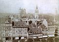
Photo from around 1900: West side of Bohlweg seen from Braunschweig Castle . In the background the towers of (from left to right): Brunswick Cathedral , Brunswick Town Hall and St. Andrew's Church .

Similar point of view in 2010.

In the time of the economic miracle , built in the 1950s on Bohlweg and now a listed building, “Save with us” neon sign for a financial institute, showing all coins of the new currency at the time .

The historic Credé motor car (Tw) 113, a museum car for the Braunschweig tram , was installed in 2009 on tracks that have meanwhile been relocated to the east side of the street at the level of the former location of the old ministry , which is now also used to accommodate the city administration's offices No. 52 is built over.

Photo from 2009: At the Rathaus tram stop with a view of the building of the reconstructed castle (with attached quadriga ) and a department store (with a so-called Eiermann facade clad with hydrangea tiles ) dominating the street in the southern part of Bohlweg .

View of Bohlweg from the intersection of Stobenstraße / Waisenhausdamm ( looking north).


.JPG)


.JPG)
literature
- Camerer, Garzmann, Schuegraf, Pingel: Braunschweiger Stadtlexikon , Braunschweig 1992, ISBN 3-926701-14-5
- Hermann Dürre : The Bohlweg in Braunschweig around the year 1400. A contribution to the urban topography in the Middle Ages , In: Braunschweigisches Magazin , Braunschweig 1860, 12th, 13th and 14th piece
- Jürgen Hodemacher : Braunschweigs streets - their names and their stories, Volume 1: Innenstadt , Cremlingen 1995, ISBN 3-927060-11-9
- Wolfgang Kimpflinger: Monument topography Federal Republic of Germany . Architectural monuments in Lower Saxony , Volume 1.1 .: City of Braunschweig , Part 1, Hameln 1993, ISBN 3-87585-252-4
- Heinrich Meier : The street names of the city of Braunschweig , in: Sources and research on Braunschweigischen history , Volume 1, Wolfenbüttel 1904
Individual evidence
- ^ "... because otherwise you could only get through the swampy urban area on overlaid boards or planks (from which the Bohlweg kept its name until now)." In: Carl Georg Heinrich Lentz : Books of the stories of the Lande Braunschweig and Hanover , 2nd verb . Edition, Braunschweig 1840, p. 50
- ↑ “Although the named parts of the city stood there, one should of course not believe that they were even remotely similar to the present city; for once the buildings were scattered about in it, surrounded by bushes and swamps, and furthermore no paving of the roads was to be thought of. The current naming of the streets, such as the Bohlweg, which one had to cover with planks in order to be able to pass it, and the break give clear evidence of the impassability of the streets. ” In: August Lambrecht : Das Herzogthum Braunschweig: Geographisch, geschichtlich and presented statistically for use in the home and school , Wolfenbüttel 1863, p. 279
- ↑ a b Overview of the accommodation of the departments and departments of the city administration . In: City of Braunschweig, Department of Central Services (Ed.): Handbook and telephone directory of the city administration 2009/2010 . Heise address book, March 2009, ISSN 0931-2986 , p. 10–11 (The ISSN printed in does not result in a hit in the ZDB. Compare, however, ZDB -ID 2032014-0 ).
- ↑ Braunschweig city center 1938 . Map 1: 2500. In: Richard Borek Foundation / City of Braunschweig (Hrsg.): Historical-Synoptic map of the Braunschweig city center . 1938/2010. 2nd, expanded edition. Braunschweig 2010, ISBN 978-3-00-029747-2 (revised by the municipal surveying office - originally developed by Reinhard Liess, Harald-Michael Wolff and Johannes Preußner - three-part historical map of the city of Braunschweig in a synoptic representation by overlaying the city maps from 1938 and 2010 ; with the accompanying brochure by Udo Gebauhr: Considerations on the city plan ).
- ^ Elmar Arnhold / Sándor Kotyrba: Braunschweig - Cityscape in Transition. 1893 and 2010 (= Arnhold & Kotyrba architecture guide ). 1st edition. Braunschweig 2010, ISBN 978-3-942712-01-9 , Bohlweg, p. 50–51 (“1891–94, the southern part of the building on Dankwardstrasse was built for the financial administration of the Duchy of Braunschweig.”).
- ^ A. Pabst: Banks and cooperatives - old and new financial institutions . In: Friedrich August Knost (ed.): Braunschweig - creating land . A book from the Lower Saxony administrative district of Braunschweig. Stalling, Oldenburg (Oldb) / Hamburg 1957, DNB 99023942X , Die Wirtschaft, p. 184–194 (photo by G. Teubner on p. 186 shows the headquarters of the Braunschweigische Staatsbank).
- ^ Elmar Arnhold / Sándor Kotyrba: Braunschweig - Cityscape in Transition. 1893 and 2010 (= Arnhold & Kotyrba architecture guide ). 1st edition. Braunschweig 2010, ISBN 978-3-942712-01-9 , Bohlweg, p. 51 (“After the existing building structure of the Pauline monastery was demolished, the extension for the State Ministry was built in 1909–13.”).
- ↑ Braunschweig car park list. In: tram-info.de. Working group tram-info, December 8, 2011, accessed on December 11, 2011 : "Vehicles for special traffic - historic railcars"
Web links
- www.braunschweig.de City of Braunschweig - aerial photos from Bohlweg
Radeklint | Long road | Küchenstrasse | Hagenbrücke | Hagenmarkt | Bohlweg | Wilhelmstrasse | Knight's Fountain | Stobenstrasse | Aegidia Market | Auguststrasse | John F. Kennedy Square | Augusttorwall | Lessingplatz | Rivendell Wall | Kalenwall | Konrad-Adenauer-Strasse | Europaplatz | Gieseler | Güldenstrasse
Coordinates: 52 ° 15 ′ 53 " N , 10 ° 31 ′ 34.7" E