
Meinhardshof
| Meinhardshof | |
|---|---|
|
|
|
.JPG) |
|
| View from the south tower of the Andreaskirche to the 7-lane Meinhardshof in 2005 | |
| Basic data | |
| place | Braunschweig |
| District | Downtown |
| Created | 15th century |
| Newly designed | after 1945 |
| Hist. Names |
Embernshof (1320), Membernshof (1331), Meimerhof (1606) |
| Connecting roads | Old scales |
| Cross streets | Butt brothers , Schild , Lange Strasse , Küchenstrasse , Jöddenstrasse |
| use | |
| User groups | Foot traffic , car traffic |
| Technical specifications | |
| Street length | 80 m |
The Meinhardshof is a broad, short street in the northern city of Braunschweig , at the junction of precincts bag and Neustadt . It runs vertically from north to south. Built in the 14th century, the entire half-timbered building was completely destroyed by the bombing of the Second World War , in particular by the bombing of October 15, 1944 . The fallow land to the right and left of the once narrow lane served as business premises to the west soon after the end of the war, and to the east until the 1970s, among other things, as a parking lot , with the exception of the bomb wasteland on the east side of Meinhardshof in the early 1980s, the Welfenhof , a combination of shops , Residential and office buildings and a hotel.
Today the Meinhardshof is only 80 m short and over 30 m wide, seven-lane street, which is used almost exclusively for entering or exiting the underground car park of the Welfenhof shopping mall .
history
etymology
It is believed that in the area where Meinhardshof runs today , there was an estate at the beginning of the 14th century . Its owner to a man named Ember have been, so that the court in 1320 as Hern Emberns Hof , 1329 and 1338 Embernshof also, or by phonetic slurring as Membernshof or Memberns hove been designated. Nothing else has been transmitted via Ember. In the centuries that followed the naming varied in many ways: for 1424 is Memeringeshoff for 1450 Meymeringshof and 1457 Meymershof occupied. 1580 states Meiboriushoff , in city maps 1606 Meimerhof , 1671 Meymersch-Hoff and other variants, the plot was in the land registers finally in 1700 as Meinhardshof designated. Meinhardshof also appears in Friedrich Wilhelm Culemann's map from 1798 , while Der Meimers Hoff can be found in Albrecht Heinrich Carl Conradi's map from 1755 .
On the other hand, a derivation of the street name from an extinct family von Meiners , as Anton August Beck in 1758 or Philip Christian Ribbentrop in 1789 suspected in the description of the city of Braunschweig or as Friedrich Knoll mentioned in the late 19th century , found no further support. Even Karl Scheller deriving from the verb meimern for do crazy tricks or Tollhof (of great , in the sense of madness ), the interpretation of Meinbornshof as an indication of an existing Gemeindebrunnenhof could not substantiate.
Design and development
.jpg&filetimestamp=20120205133319&)
.jpg&filetimestamp=20171210054026&)
The Meinhardshof had over the centuries by a court in a brief, is conically developed narrowing north street or alley. In the south the street was still quite wide, but narrowed so strongly to the north that the residents on the upper floors of the cantilevered houses could almost shake hands through the windows. An S-shaped "kink" to the west in the lower third was characteristic of the course. Until 1944 , the buildings consisted exclusively of half-timbered houses , which essentially came from the 16th century. Already at the beginning of the 20th century, the Meinhardshof was considered extremely picturesque and one of the last closed, medieval -looking streets in the Braunschweig city center. Archaeological excavations between 1976 and 1992 showed that mostly small craft businesses and traders had been based in this area. Coming from the east, the small Jöddenstrasse (= Judenstrasse) ran into the upper third . in the Meinhardshof . The Jews of Braunschweiger Neustadt had settled there since around the 13th century, but Christians also lived there. Since the living space on Jöddenstrasse was very limited, a first Jew moved to Meinhardshof at the beginning of the 14th century .
Some of the houses were: Meinhardshof 3 ( Assekuranznummer 2750), built in 1531. During the time of National Socialism and the Holocaust , the National Socialists in Braunschweig, as in countless other parts of the German Reich , designated special houses as so-called Jewish houses , where fellow citizens of the Jewish faith had to take up residence until they were deported to concentration and extermination camps . The four-story half-timbered house Meinhardshof 3 was one of the Jewish houses in the city of Braunschweig . The short and textile goods store of the Jewish Kohn family was located on the ground floor until “ Aryanization ” . All residents of the house were deported to the Theresienstadt concentration camp in the spring of 1943 . Meinhardshof 5 : The Brunswick woodcarver Hermann Scheller is said to have lived here from 1674 to 1693 . Meinhardshof 9 (ass. 2756), was built in 1558.

Meinhardshof 11 (ass. 1368), was built in 1543. The house had a front length of 12 spans and was the largest in the street; possibly it was the rest of the former estate of Mr. Ember. As a house brand it had a trout. It stood directly opposite the confluence with Jöddenstrasse and served, among other things, as a council forge . One of the residents of the house was a Brunswick original around 1880 , the well builder Carl Verdrieß.
Meinhardshof 13 (ass. 2758), was built in 1543, according to Fricke around 1490 . Meinhardshof 17 (ass. 2762), was built in 1504 ( anno dom (ini) m vc un (de) iiii in the S (ancti) Gregorii ). In front of the property at Meinhardshof 18-19 there was a 9 m² square with a neighborhood fountain that was jointly owned by the residents. It was used until the Meinhardshof was destroyed in 1944.
At the corner of Hinter Brüdern 27/30 and Meinhardshof , the Brunswick trading company CW Böttger - Grüner Löwe , founded in 1865 , was located there until its closure in 1982.
Urban environment
In the immediate vicinity of the Meinhardshof were or are among others:
- north: Wollmarkt , Alte Waage , Andreaskirche and Liberei
- east: Neustadtrathaus and Packhof
- to the west: Brothers Church with monastery
- south: Kannengießerstraße and Alter Zeughof
Impressions
- From 1755 to 1900

Excerpt from the map of AHC Conradi around 1755: In the center the Pack Hauß , north of it the Der Meimers Hoff , into which the Jödden Straße opens .

Excerpt from the map of FW Culemann from 1798: In the center of the Packhof , north of the Meinhards Hof . Right the road in front of the customs booth , today cuisine road ..

1879, painting by Franz Alt : View through a Braunschweiger Gasse with the St. Andrew's Church and the old scales
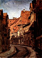
Around 1880, painting by Carl Josef Alois Bourdet : Meinhardshof von Norden
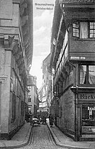
Around 1900, view from the north into the Meinhardshof. The street sign Lange Straße can be read at the top right .

_Meinhardshof.JPG&filetimestamp=20171210062418&)


.jpg&filetimestamp=20120205133319)
.jpg&filetimestamp=20171210054026)
destruction
The entire development of Meinhardshof , like most of the Braunschweig city center , was lost in the nights of bombing during World War II. At the end of the war, the degree of destruction within the Okerring , where the Meinhardshof was also located, was 90%. Braunschweig is thus one of the twelve German cities most severely damaged by the war.
literature
- Johannes Angel: Meinhardshof. In: Luitgard Camerer , Manfred Garzmann , Wolf-Dieter Schuegraf (eds.): Braunschweiger Stadtlexikon . Joh. Heinr. Meyer Verlag, Braunschweig 1992, ISBN 3-926701-14-5 , p. 156 .
- H. Edel: The half-timbered houses of the city of Braunschweig. A picture of art and cultural history. Appelhans Verlag, Braunschweig 1928, pp. 36-39.
- Rudolf Fricke : The community center in Braunschweig. In: The German community center. Volume 20, Ernst Wasmuth, Tübingen 1975, ISBN 3-8030-0022-X .
- Dieter Heitefuß: Risen from the rubble. Braunschweig and its reconstruction after 1945. A picture documentation. Braunschweig 2005, ISBN 3-9803243-5-4 .
- Jürgen Hodemacher : Braunschweig's streets, their names and their stories. Volume 1: Inner City. Cremlingen 1995, ISBN 3-927060-11-9 , pp. 218-219.
- Heinrich Meier : The street names of the city of Braunschweig. In: Sources and research on Brunswick history. Volume 1, Wolfenbüttel 1904, pp. 74-75.
- Paul Jonas Meier , Karl Steinacker : The architectural and art monuments of the city of Braunschweig. 2nd, expanded edition. Braunschweig 1926, pp. 90-91.
- Norman-Mathias Pingel: Everyday life in Meinhardshof. In memory of one of the most famous streets in old Braunschweig. In: Braunschweigischer Kalender . 2006. Braunschweig 2005, pp. 77-80.
Web links
Individual evidence
- ^ Paul Jonas Meier: Investigations into the beginnings of the city of Braunschweig. In: Paul Zimmermann (Ed.): Yearbook of the history association for the Duchy of Braunschweig. Volume 11, 1912, Zwißler, Wolfenbüttel p. 11.
- ^ Heinrich Meier: The street names of the city of Braunschweig. P. 74.
- ↑ a b c Friedrich Knoll : Braunschweig and the surrounding area: historical-topographical manual and guide through the monuments and art treasures of the city. Braunschweig 1881, p. 96.
- ↑ Karl. FA Scheller : Book studies of the Sassian-Low German language: mainly based on the written monuments of the Herzogl. Library in Wolfenbüttel designed Braunschweig 1826, p. 462.
- ^ Heinrich Meier: The street names of the city of Braunschweig. P. 75.
- ^ Dieter Heitefuss: Braunschweig. Yesterday and today. Braunschweig 1993, ISBN 3-9803243-1-1 , p. 66.
- ^ H. Edel: The half-timbered houses of the city of Braunschweig. P. 38.
- ^ Gerd Spies : Old Braunschweig. Graphic and pictorial representations from five centuries. Weidlich, Frankfurt am Main 1977, p. 58.
- ↑ Ingolf Ericsson , Hans Losert , Walter Sage : Aspects of the archeology of the Middle Ages and modern times. Festschrift for Walter Sage. R. Habelt 2003, p. 212.
- ↑ Hans-Heinrich Ebeling : The Jews in Braunschweig: Legal, social and economic history from the beginnings of the Jewish community to emancipation (1282-1848). In: Braunschweiger workpieces. Volume 65, Braunschweig 1987, ISBN 3-87884-034-9 , p. 78.
- ↑ Sabine Wehking : DI 56, City of Braunschweig II, A1, No. 3 † on insschriften.net
- ^ Bert Bilzer , Richard Moderhack (ed.): Brunsvicensia Judaica. Memorial book for the Jewish fellow citizens of the city of Braunschweig 1933–1945. In: Braunschweiger workpieces. Volume 35, Braunschweig 1966, p. 183.
- ^ B. Bilzer, R. Moderhack (eds.): Brunsvicensia Judaica. Memorial book for the Jewish fellow citizens of the city of Braunschweig 1933–1945. P. 183.
- ^ B. Bilzer, R. Moderhack (eds.): Brunsvicensia Judaica. Memorial book for the Jewish fellow citizens of the city of Braunschweig 1933–1945. P. 161.
- ↑ Susanne König-Lein: Scheller, Hermann. In: Horst-Rüdiger Jarck , Dieter Lent et al. (Ed.): Braunschweigisches Biographisches Lexikon - 8th to 18th century . Appelhans Verlag, Braunschweig 2006, ISBN 3-937664-46-7 , p. 616-617 .
- ↑ Sabine Wehking: DI 56, City of Braunschweig II, A1, No. 77 † on inschriften.net
- ^ Carl Lachner: The north German timber construction in its historical development. Seemann, Leipzig 1885, p. 72.
- ^ Steinacker Meier: The architectural and art monuments of the city of Braunschweig. P. 91.
- ^ A b Rudolf Fricke: The community center in Braunschweig. In: The German community center. P. 160.
- ↑ Sabine Wehking: DI 56, City of Braunschweig II, A1, No. 32 † on insschriften.net
- ^ H. Edel: The half-timbered houses of the city of Braunschweig. P. 39.
- ^ Sabine Wehking: DI 56, City of Braunschweig II, A1, No. 33 † on inschriften.net
- ↑ Andrea Boockmann: DI 35, City of Braunschweig I, No. 315 † on inschriften.net
- ^ Wilhelm Appelt, Theodor Müller : Water arts and waterworks of the city of Braunschweig. In: Braunschweiger workpieces. Volume 33, Waisenhaus-Buchdruckerei und Verlag, Braunschweig 1964, OCLC 5037379 , p. 36.
- ↑ Britta Berg: Böttger, CW In: Luitgard Camerer , Manfred Garzmann , Wolf-Dieter Schuegraf (ed.): Braunschweiger Stadtlexikon . Joh. Heinr. Meyer Verlag, Braunschweig 1992, ISBN 3-926701-14-5 , p. 37 .
- ↑ Jörg Friedrich : The fire. Germany in the bombing war 1940–1945. Propylaen Verlag, Munich 2002, ISBN 3-549-07165-5 , p. 235.
- ↑ Rudolf Prescher : The red rooster over Braunschweig. Air raid protection measures and air war incidents in the city of Braunschweig from 1927 to 1945. p. 112.
- ^ Helmut Weihsmann : Building under the swastika. Architecture of doom. Promedia Druck- und Verlagsgesellschaft, Vienna 1998, ISBN 3-85371-113-8 , p. 306.
Coordinates: 52 ° 15 ′ 57.9 ″ N , 10 ° 31 ′ 11.9 ″ E