
Hamburger Strasse (Braunschweig)
| Hamburger Street | |
|---|---|
|
|
|
 |
|
| Hamburger Str. Corner of Siegfriedstrasse. | |
| Basic data | |
| place | Braunschweig |
| District | District 331 - Nordstadt |
| Created | In the middle ages |
| Connecting roads | Gifhorner Strasse (K 2) |
| Cross streets | to the west: on the Black Mountains; Karl-Schmidt-Strasse; Heron road; Wendenring to the east: Rheingoldstrasse; Siegfriedstrasse; Isoldestrasse; Dead end; Ludwigstrasse; Vine ring |
| Places | Schützenplatz |
| Buildings | Eintracht Stadium ; Schmalbach-Lubeca building; Municipal Health Department; Water world (swimming pool) |
| use | |
| User groups | Pedestrian traffic , bicycle traffic , car traffic , public transport |
| Road design | Four lanes with tram tracks |
| Technical specifications | |
| Street length | about 1,900 m |
The Hamburger Straße is one of the busiest entry and exit roads of the city of Braunschweig .
geography
Hamburger Strasse is located in the north of the city of Braunschweig and runs between the Schwarzer Berg district and the Siegfriedviertel . In the south it begins on the northern part of the inner city ring, at the transition from the western Wendenring to the eastern Rebenring. In the north it turns into Gifhorner Straße, K 2 , where the Braunschweig Volkswagen factory is located directly behind the Eintracht Stadium . Via the motorway exit Braunschweig Celler Straße / Hamburger Straße, it is connected to the Ölper motorway junction , which connects the west and north bypasses. The section between the inner city ring and the motorway connection also forms a section of federal highway 4 . To the west of Hamburger Straße are the Oker and the Ölpersee , which flow in parallel .
history
Hamburger Strasse was already used as a trade and military route in the Middle Ages and led from Braunschweig to the Hanseatic city of Hamburg . As early as 1797, the first “ Jewish cemetery ” was laid out in the area of the street , at that time still far outside the city limits. On its western side there has been Schützenplatz since 1890, where annual markets such as the Braunschweiger Masch are held regularly.
In 1898 Johann Andreas Schmalbauch (1851–1904) founded the tin goods factory " JA Schmalbauch " to manufacture a new type of tin for the preservation of asparagus in particular, but also of other agricultural products. Around this time, the entrepreneur Friedrich Jürgens also founded the “ Friedrich Jürgens Brewery ” on Hamburger Strasse .
By the middle of the 20th century, the road in the south began at the Wendentor on the Okerum flood . The Okerum flood formed the outer city limits of Braunschweig until the early modern times . This section of the street, near the Braunschweig city center, developed into an early industrial and commercial area as early as 1800.
In the 1840s there were three chicory factories and an oilcloth factory on a 300 m long section between the Wendentor and today's inner city ring . After the establishment of the Technical University (today the Technical University of Braunschweig ) in Nordstadt , the character of this area changed from 1877 onwards. The Ludwig Otto Bleibtreu chicory factory was the last production facility in this area to close around 1909.
It was not until 1946 that the street section between the Wendentor and the inner city ring was renamed Mühlenpfordtstraße , in honor of the architect and university professor Carl Mühlenpfordt (1878–1944).

Jewish cemetery on Hamburger Strasse

JA Schmalbach factory

Eintracht Stadium and Volkswagen factory in Braunschweig

Oil lake
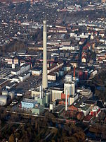
Central heating plant
.JPG)
.JPG)


.JPG)
More residents
- The technology center of the Braunschweig Chamber of Crafts (TZH Braunschweig) with its 29 workshops and 10 classrooms and PC rooms.
- A branch of the Johannes Selenka vocational school.
- The Braunschweig Health Department.
- The outpatient rehabilitation center Braunschweig.
- The Braunschweig branch of the packaging manufacturer Ardagh Metal Packaging Germany GmbH was part of Ball Packaging Europe as a beverage can lid plant until mid-2016 . Access via Karl-Schmidt-Straße.
- The central heating plant with its chimney that can be seen from afar.
- At Schützenplatz, the Braunschweig Water World, a new adventure pool.
Web links
Individual evidence
- ↑ Reinhard Bein : Eternal House - Jewish cemeteries in the city and country of Braunschweig. Braunschweig 2004, p. 31 ff, especially p. 33. Location of the Jewish cemetery on d-friedhof.de
- ↑ Braunschweig Masch. On braunschweig.de
- ↑ Agriculture → Schmalbach preserved food → Schmalbach preserved food (4.1.4) on gibs.info
- ↑ National-Jürgens-Brauerei (NJB) until 1977. on braunschweig.de
- ^ Office for statistics and elections of the city of Braunschweig (ed.): Administrative report of the city of Braunschweig 1945–1946. Braunschweig 1948, p. 2.
- ↑ Braunschweig Technology Center at hwk-bls.de.
- ↑ Johannes Selenka School on braunschweig.de.
- ↑ Health Department on braunschweig.de
- ↑ Outpatient Rehabilitation Center at rehazentrum-braunschweig.de
- ^ Metal → Germany → Braunschweig. on ardaghgroup.com.
-
↑ Ball Braunschweig ( memento from January 6, 2013 in the Internet Archive ) on ball-europe.com;
Ardagh wins the race for Ball and Rexam beverage can plants. on euwid-verpackung.de. - ↑ Central heating plant on bs-energy.de
Coordinates: 52 ° 17 ' N , 10 ° 31' E