Mühlenpfordtstrasse
| Mühlenpfordtstrasse | |
|---|---|
| Street in Braunschweig | |
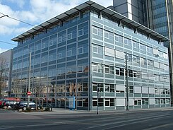
| Computer science center of the TU Braunschweig in the Mühlenpfordtstrasse | |
| Basic data | |
| place | Braunschweig |
| District | District 331 - Nordstadt |
| Connecting roads | north: Rebenring, south: Am Wendentor. |
| Cross streets | to the west: at the Wendenwehr; Wendenmaschstrasse, to the east: Schleinitzstrasse; Katharinenstrasse. |
| Buildings | Computer science center of the TU Braunschweig; Architectural high-rise of the TU Braunschweig |
| use | |
| User groups | Pedestrian traffic , bicycle traffic , car traffic , public transport |
| Road design | Two lanes with tram tracks |
| Technical specifications | |
| Street length | about 300 m |
The Mühlenpfordtstraße is north of the city of Braunschweig and connects, running in a north-south direction, the city center with the northern part of the city ring.
In the south it begins at the street Am Wendentor (with the Wendentor bridge over the Okerum flood ) and meets the transverse Rebenring in the north .
history
Until the middle of the 20th century, the street formed the southern section of Hamburger Straße . This street was already used as a trade and military route in the Middle Ages and led from Braunschweig to the Hanseatic city of Hamburg . The street section between Wendentor and the Rebenring was not given its current name until 1946, in honor of the architect and university professor Carl Mühlenpfordt (1878-1944).
The Okerum flood formed the outer city limits of Braunschweig until the early modern times . After the fortifications of the city of Braunschweig lost their military importance in the middle of the 18th century, the demolition of the ramparts began in the first decade of the 19th century .
When around 1800 citizens of Braunschweig complained about the smoke caused by commercial operations in the densely built-up city center, numerous manufacturers moved their production facilities to what was then the city limits, to today's Mühlenpfordtstraße in front of the Wendentor, also for fire protection reasons.
During this time the street developed into an early industrial and commercial area. In the 1840s, there were three chicory factories and an oilcloth factory between the Wendentor and today's inner city ring, on the almost 300 m long section .
After the establishment of the Technical University (today the Technical University of Braunschweig ) in Nordstadt , the character of this area changed from 1877 onwards. The Ludwig Otto Bleibtreu chicory factory was the last production facility in this area to close around 1909.
Today's development
Today the Mühlenpfordtstrasse in Braunschweig is characterized by the buildings with facilities of the Technical University, such as the IT center, the so-called "Architectural Tower" and the student dormitory of the East Lower Saxony student union on Rebenring.
In addition, there are residential and commercial buildings, mostly multi-storey post-war buildings in closed construction, with retail shops or restaurants on the ground floor.
literature
- Jürgen Hodemacher : Braunschweig's streets - their names and their stories . Volume 2: Okergraben and city ring . Cremlingen 1996, ISBN 3-927060-12-7 , p. 218 f.
Web links
- Mühlenpfordtstraße on strassenkatalog.de
Individual evidence
- ^ Office for statistics and elections of the city of Braunschweig (ed.): Administrative report of the city of Braunschweig 1945–1946 . Braunschweig 1948, p. 2.
- ^ Karl Liedke, Bernd Rother : From the sugar factory to the microchip: Braunschweig's industry from 1850 to today . Dipa-Verlag, Frankfurt am Main 1989, p. 10, ISBN 3-7638-0309-2 .
Coordinates: 52 ° 16 ′ 27 ″ N , 10 ° 31 ′ 28 ″ E


