
Fortifications of the city of Braunschweig


The fortifications of the city of Braunschweig were a system of defensive systems of the city of Braunschweig that existed from around 1000 to the end of the 18th century. A few remains of these systems are still preserved today, such as B. a remnant of the city wall from the 15th century on Prinzenweg or the ramparts that surround today's Braunschweig city center within the Okerring .
history
Braunschweig's fortifications were erected over a period of around eight centuries. During this period, the systems were gradually built up and expanded or abandoned and razed in accordance with the respective defense requirements. All of these institutions for the defense of the city of Braunschweig never existed in their entirety at the same time.
In early medieval in the flowed resin springing Oker in a 200 to 500 m wide flood plain through the field of today's city, which was then crossed by several tributaries. It is believed that around the year 1000 at the latest a merchant settlement was established in the area of today's Kohlmarkt . At this intersection of two long-distance trade routes , a ford could be used to cross the river. At the same time, there was the possibility of moving goods to the water, as land transport was laborious and unsafe. At that time the river was navigable beyond Braunschweig.
It is assumed that the houses and courtyards of the settlement were initially secured and fortified individually. These fortifications, which were cost-intensive but ineffective for the individual farm owners, soon made a first common wall necessary. The last remaining remnant of such an individual enclosing wall is located in Stephanstraße ( ⊙ ) in the Braunschweig city center. Today the wall forms part of the facade of a house built later.
In the centuries that followed, further settlements were built around the first settlement core, which were legally independent of each other and, as so-called soft structures, each had its own town hall , its own council , its own parish church and its own fortifications. The Weichbilden retained their independence until 1671, when the era of the independent city of Braunschweig was ended by the reconquest of the princes of Braunschweig-Wolfenbüttel .
Although the city of Braunschweig was not yet a cohesive entity in the Middle Ages, the need for an effective defense made it necessary to build a city wall with ditches and ramparts that enclosed the closely spaced muds.
In front of the city, upstream fortifications were built, such as the Braunschweiger Landwehr , which was about four to five kilometers from its gates. The most distant fortifications were castles and defense towers in the surrounding area, such as the Asseburg near the city of Wolfenbüttel and Vechelde Castle . These castles secured important long-distance trade routes for the city in the border area of neighboring and often hostile territories, such as that of the dukes of the principality of Braunschweig-Wolfenbüttel and the Hildesheim monastery .
Remains still preserved today
In the middle of the 18th century the facilities lost their military importance, so that they were abandoned around 1769. In the first decade of the 19th century, the razing of the ramparts began and the rampart ring was created, today an ensemble of parks , promenades , squares and residential areas.
In 1835 the redesign was completed. Remains of the city wall from the 15th century and the two so-called "flood ditches" have been preserved. These trenches still flow around the city center today. In the park of the Wallring, the hills of the former bastions form unmistakable heights in the otherwise flat urban landscape .
The inner attachment

|

|
|
|
The “Redingetor” on Bohlweg in Braunschweig. Canceled in 1798.
|
The "Long Bridge" with gate and bridge tower around 1650. 19th century lithograph.
|
Until 1671, the city of Braunschweig consisted of five legally independent Weichbilden ( Altewiek , Altstadt , Hagen , Neustadt and Sack ) as well as two other city districts, the Aegidien Freedom around St. Aegidien Monastery and the Burg Freedom with the Dankwarderode Castle .
The soft formations were not only walled on the outside, but also separated from each other by walls and secured with defensive towers. City gates created connections such as the “Gate on the Long Bridge ” and the “Leuentor” between the old town and Altewiek, the “Redingetor” on Bohlweg between Altewiek and Hagen and the “Gildenor” or “Judentor” between Hagen and Neustadt.
The old town and the new town were walled and ditched before 1149, the Hagen around 1170, the Altewiek only around 1200. In the 13th century, the removal of the soft-walled walls within the city began again in favor of an outer, shared city wall.
The castle lost its importance as a bulwark of the city early on. The walls of the castle, demolished in the 1580s, became militarily insignificant when the castle was surrounded by new mounds. The moat existed until 1798 and was then channeled underground to make space for new buildings.
The external attachment
City wall, moats and ramparts

There are no traces of the earliest walls surrounding the city from the 12th century. It is assumed, however, that the location of this wall corresponded roughly to the city wall that was recorded in the plans of the city in 1671. Larger relocations due to city expansion were probably in the northeast of the city, in the area of the soft patch Hagen.

In the middle of the 12th century, the Oker was diverted around the city by means of wall moats. In the south of the city was the " Eisenbütteler Wehr ", which dammed the river in order to divert it in two large "flood ditches" east and west around the city. In the northwest, both arms of the Oker flowed together again. The flood ditches were built with ramparts until the middle of the 18th century to form a strong city fortification . These trenches still border the historic city center of Braunschweig today.
The city wall system of the 14th century consisted of the flood ditch on its outside and another wall ditch on its inner side, facing the city. The excavated earth was piled up like a dam and the wall was placed on it. On the inside, the wall was backfilled with more earth. In order to secure the wall against the pressure of the backfilling, it received brick buttresses on its outside. The maintenance and guarding of the individual city wall sections and city gates was subject to the advice of the individual Weichbilders. The Neustadtmühlengraben and the Bosselgraben are the only ones of the inner wall moats that have been almost completely preserved.
Thanks to its strong, effective walls, the city was able to withstand the sieges of 1550, 1553, 1605 and 1615. Unlike the neighboring cities of Wolfenbüttel and Magdeburg , Braunschweig also emerged unscathed from the turmoil of the Thirty Years' War .
City gates and towers

Originally there were ten city gates that served as a passage for traffic: the Magnitor , Aegidientor , Bruchtor , Michaelistor , the Hohe Tor , Petritor , Neustadttor , Wendentor , Fallersleber Tor and the Steintor . Four gates bore the names of the churches in whose vicinity they were built ( Magni , Aegidien , Michaelis and Petrikirche ). The names of three gates indicate their location (Bruchtor, the Hohe Tor and Neustadttor) and three gates bore the names of the streets whose endpoints they formed ( Wendenstraße , Fallersleber Straße and Steinweg ).

The gates usually consisted of an outer and an inner gate, each of which was built over or flanked by a gate tower . It is assumed that all outer gate towers were built as so-called round kennels . During the expansion of the city into a bastionary fortification, the number of city gates was reduced from 1693. After the Neustadt Gate (1693) and the Magnitor (1720) were closed, eight gates were still available.
Wall towers were built along the walls to secure them . It is believed that there were up to 41 wall towers, most of which served as gun emplacements . The mightiest of these towers were also referred to as ' castles ', such as the Bammelsburg on today's Inselwall and the St. Michaelisburg on the site of today's Stobwasserhaus in Echternstrasse .
With the use of heavy artillery gates and towers lost their importance for the defense of the city. It was demolished in the second half of the 18th century.

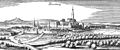
The gates from the left: Neustadttor, Altes Petritor, Hohestor and Michaelistor.
| City gate | location | First mention |
New building | demolition | comment | |
|---|---|---|---|---|---|---|
| Aegidientor (August Gate) ⊙ |
|
- | 1621, 1730 |
1728, after 1806 |
The new building, completed around 1730, was named "Augusttor", named after Duke August Wilhelm (1662–1731). | |
| Bruchtor (Südmühlentor) ⊙ |
|
1378 | 1568 | 1788 | The “Bruchtor”, also “Südmühlentor”, was mentioned as early as 1378 when a miller from Brunswick rented the upper floors of the gate tower. This was done on the condition that no 'loose women' be accommodated there. Even today, Bruchstrasse with its numerous brothels is the center of the city's red light district . |
|
| Michaelistor ⊙ Wilhelmitor ⊙ |
|
1354 | 1540-1541 | 1768-1794 | In 1716 the "Michaelistor" was closed for carts. It was replaced by the "Wilhelmitor" built in 1716, named after Duke August Wilhelm. |
|
| The high gate ⊙ |
|
1255 | 1490 | 1788-1793 | The "Hohe Tor" with its kennel and a wall thickness of 1.75 meters was one of the mightiest structures of a medieval fortification in Lower Saxony. It is believed that the tower of the "High Gate" was built in the second half of the 12th century. The gate was built from Braunschweig Rogenstein vom Nußberg . Remnants of the foundation of the “High Gate” were discovered in 2003 during ground work on the western ditch of the Okerum flood. An engraving by Peter Spitzer (around 1510 - after 1578) from 1547 shows the tower of the “High Gate” with the city wall behind the fortifications in front. |
|
| The Old Petritor ⊙ The New Petritor ⊙ |
|
1345 | 1568, 1707 |
1753–1791, around 1800 |
The "Old Petritor", which was closed in 1707, was replaced by the "New Petritor" built elsewhere. | |
| The Neustadttor ⊙ |
|
1297-1331 | 1433 1569 |
1793 | In 1567, the gravestones of the victims of the plague who had died a year earlier were used for repair work . The gate was closed in 1693 and was no longer used as a city gate until it was demolished. |
|
| Reversing gate ⊙ |
|
- | 1476 | 1780 | Extension by an outer gate tower as a kennel in the years 1581–1589. | |
| Fallersleber Gate ⊙ |
|
- | 1483 | 1786-1800 | The tower of the “Fallersleber Tor” was supported by pile foundations because of the swampy subsoil . The analysis of this wood allowed the exact determination of the building to the year 1169. The Zwinger, built in 1483, was only demolished in 1808.
|
|
| Stone gate ⊙ |
|
1349 | 1625 1667 |
1771-1805 | The "stone gate" formed a joint system with a second gate, the "Friesentor". | |
| Magnitor ⊙ |
|
1380 | 1469-1477, 1587 |
1785 | When Braunschweig was expanded into a city fortress, the gate was closed around 1720 and no longer served as a city gate until it was demolished. |
.JPG)
Bulwarks

In 1671 the city of Braunschweig, which had been virtually independent since 1432, was recaptured by the princes of Braunschweig-Wolfenbüttel. In 1692 work began on converting the fortifications into a modern city fortress based on plans by the fortress master builder Johann Caspar von Völcker (1655–1730).
Völcker planned the fortifications based on the Dutch model . Seventeen bulwarks (bastions) and ramparts with the formation of curtains , ravelins and glacies were built . The bulwarks were mostly given the names of people from the royal family who lived at the time. The work was not yet completed in 1730, the year Völcker died. His successor Johann Georg Möring continued the construction until 1740.
Already at this point it was recognized that the fortification method was out of date. In the course of the 18th century, warfare changed from siege warfare to open field battle. Nevertheless, the fortification was expanded again in 1762 during the Seven Years' War after a French siege.
From 1803 the fortifications were razed under the direction of the architect Peter Joseph Krahe (1758–1840) . In their place, the park of the Wallring was created, in which the hills of the former bastions, such as the "Christinenbollwerk", today's "Windmühlenberg", still form prominent hills in the otherwise flat urban landscape.

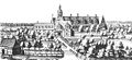
In the center of the picture the Anton's bulwark and the stone gate.
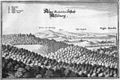
The bastions and ramparts of Braunschweig around 1765, starting from the Augusttor in the southeast in a clockwise direction. .png)
|
|||
| No. | Bulwark | Armament in 1768 |
comment |
|---|---|---|---|
| 1. | Christine's bulwark ⊙ |
4 cannons | Today's "Windmühlenberg" was the location of a windmill from 1785 to around 1830. |
| 2. | Louisen Bulwark ⊙ |
3 cannons | in the area of today's Lessingplatz / Nîmes-Straße. |
| 3. | The abdominal wall ⊙ |
3 cannons | Detached bulwark, today Kiryat-Tivon-Park . |
| 4th | The “Bald Wall” ⊙ |
2 cannons | detached bulwark; the Kalenwall is now part of the Braunschweiger Cityring as a street . |
| 5. | Eugenius bulwark ⊙ |
2 cannons | in the area of today's Gieselerwall / Ferdinandstrasse. |
| 6th | Ferdinand's bulwark ⊙ |
2 cannons | in the area of today's Pawelstrasse / Am Hohen Tor. |
| 7th | Carlsbulw ⊙ |
4 cannons | today the Hohetorwall green area. |
| 8th. | Elizabeth bulwark ⊙ |
2 cannons | today Petritorwall . |
| 9. | Imperial bulwark ⊙ |
2 cannons | in the area of today's Petritorbrücke / Radeklint . |
| 10. | Ludewigsbulwerk ⊙ |
3 cannons | today Inselwallpark . |
| 11. | Rudolf's bulwark ⊙ |
2 cannons | today Gaußberg . |
| 12. | August bulwark ⊙ |
2 cannons | today turning gate wall. On August 10, 1788, the French balloonist Jean-Pierre Blanchard undertook a balloon ascent on the August bulwark. The writer Adolph Knigge processed the event into his novel Die Reise nach Braunschweig . |
| 13. | Leopold's bulwark ⊙ |
3 cannons | today Fallersleber-Tor-Wall. |
| 14th | Anton's bulwark ⊙ |
2 cannons | today theater park . |
| 15th | Ulrich's bulwark ⊙ |
2 cannons | today a museum park . |
| 16. | Friedrichsbollwerk ⊙ |
3 cannons | today stone gate wall in the area of the former cultural center " Die Brücke ". |
| 17th | Wilhelmbollwerk ⊙ |
2 cannons | today Löwenwall . |
Upstream fortifications
The Landwehr and its defense towers

In 1376 the city council decided to build another wall with the Landwehr in the Braunschweig area, well in front of the actual city fortifications. North of the city, in what is now the Ölper district , the construction of steep earth walls began. Sometimes up to three walls ran parallel, which were bordered by deep trenches.
Between 1380 and 1416 seven defense towers and keep were built: the " Gliesmaroder Turm " ( ⊙ ), " Ölper Turm " ( ⊙ ), " Raffurm " ( ⊙ ), " Rothenburger Turm " ( ⊙ ), " Rüninger Turm " ( ⊙ ) , “ Schöppenstedter Turm ” ( ⊙ ) and the “ Wendenturm ” ( ⊙ ). The towers were supposed to secure the important trade and military routes between Braunschweig and the cities of Hildesheim , Magdeburg , Lüneburg , Leipzig and Frankfurt am Main and were located about four to five kilometers, at that time about an hour, from the gates of the city.
When the Landwehr lost its military importance at the end of the 18th century, the defense towers were razed . The outbuildings went into private ownership and served as guest houses. In the 19th century, the hosts of the travelers could Chausseegeld rise, a kind of road tax. The "Rothenburger Turm" and the "Wendenturm" still serve as restaurants today.

Gliesmaroder Tower

Ölper tower

Gathering tower

Rüninger Tower

Schöppenstedter Tower

Turning tower
.jpg&filetimestamp=20110929193104&)
.jpg&filetimestamp=20111001145418&)
.jpg&filetimestamp=20110929193012&)
.jpg&filetimestamp=20111001145618&)
.jpg&filetimestamp=20110929192837&)
.jpg)
Castles and keep in the surrounding area
Asseburg ( ⊙ ), Campen Castle ( ⊙ ), Hesse Castle ( ⊙ ), Hornburg ( ⊙ ), Neubrück Castle (Nienbrügge, ⊙ ) and the castle served as the outermost fortifications on the borders of Braunschweig's possessions and as outer castles of the actual urban area Vechelde ( ⊙ ). Between the middle of the 14th century and the beginning of the 15th century, the city council had received these castles mostly as pledge from the dukes of Braunschweig-Wolfenbüttel. The city had the castles strengthened, partly rebuilt, and equipped the castle crews with firearms as early as 1420 .
As early as the 15th century, the council tried to get rid of these costly castles, some of which were located far from the city gates (up to 30 km). At the same time, however, one wanted to avoid giving them back into the possession of the mostly warring dukes. So it was decided in 1492, in a feud with Duke Heinrich the Elder (1463-1514), to give up the Asseburg and burn it down. The Asseburg, once the largest and impregnable hill fort in northern Germany , has been in ruins since then.
Campen Castle and Neubrück Castle later served as princely offices, while Hesse Castle and Vechelde Castle were the residences of the Dukes of the Principality of Braunschweig-Wolfenbüttel.
Asseburg
Castle camping
Hesse Castle
Hornburg

Neubrück Castle (Nienbrügge)

Vechelde Castle
.jpg)


.jpg)

literature
- Ewald Banse : The development of the ramparts of the city of Braunschweig from the old fortifications . In: Braunschweigisches Jahrbuch 1940 . Pp. 5-28.
- Hermann Dürre : History of the City of Braunschweig in the Middle Ages . Grüneberg, Braunschweig 1861 ( limited preview in Google book search).
- Simon Paulus, Ulrich Knufinke: The Braunschweiger Wallring. Guide to the history and architecture of a cultural and historical monument . With photographs by Heinz Kudalla, Appelhans Verlag , Braunschweig 2011, ISBN 978-3-941737-59-4 .
- Norman-Mathias Pingel: Attachment . In: Luitgard Camerer , Manfred Garzmann , Wolf-Dieter Schuegraf (eds.): Braunschweiger Stadtlexikon . Joh. Heinr. Meyer Verlag, Braunschweig 1992, ISBN 3-926701-14-5 , p. 31 .
- Julius Reissner: The Landwehr in old Braunschweig . In: Braunschweig Calendar 1968 . Meyer, Braunschweig 1968.
- Dirk Rieger: The city fortifications of Braunschweig's old town from the Middle Ages to the early modern period . In: platea finalis. Research on Braunschweig's old town in the Middle Ages . With contributions by Elmar Arnhold and Silke Grefen-Peters. In: Contributions to archeology in Lower Saxony (BAN). Volume 15, published by the Archaeological Commission for Lower Saxony e. V. , Erhard Cosack , Jörg Eckert, Betty Arndt, Jan Joost Assendorp, Jana Esther Fries and Michael Geschwinde in cooperation with the Lower Saxony State Office for Monument Preservation , Verlag Marie Leidorf, Rahden / Westf. 2010, ISBN 978-3-89646-935-9 , pp. 139-160.
- Carl Wilhelm Sack : The fortification of the city of Braunschweig . In: Archives of the Historical Association for Lower Saxony . Historical Association for Lower Saxony (Ed.), Verlag Hahnsche Hofbuchhandlung, Hanover 1847.
- Carl Wilhelm Sack : The fortification of the city of Braunschweig . In: Archives of the Historical Association for Lower Saxony . Historical Association for Lower Saxony (Ed.), Verlag Hahnsche Hofbuchhandlung, Hanover 1848.
- Hans Adolf Schultz : The Landwehr of the city of Braunschweig. Their course in the light of the latest research . In: Braunschweigische Heimat . 40th year, volume 3, E. Appelhans & Co., Braunschweig 1954.
- Werner Spieß : History of the city of Braunschweig in the post-Middle Ages . From the end of the Middle Ages to the end of urban freedom 1491–1671 . 2 volumes, Orphanage Buchdruckerei, Braunschweig 1966, OCLC 7495150 .
- Heinz Wolff : The history of the bastionary fortification of Braunschweig . Reprint of the original 1935 edition, Archiv-Verlag, Braunschweig 2002
- Monika Zeidler: Chronicle of the city of Braunschweig . Verlag Karl Pfankuch, Braunschweig 1980.
Web links
- Historical maps on the urban development of Braunschweig on the website of the city of Braunschweig, PDF, accessed on November 4, 2012
Individual evidence
- ↑ Zeidler, p. 10
- ↑ Dietmar Brandes , In: Camerer, Garzmann, Schuegraf, Pingel: Braunschweiger Stadtlexikon . Braunschweig 1992, p. 172
- ↑ Heinz-Joachim Tute, In: Camerer, Garzmann, Schuegraf, Pingel: Braunschweiger Stadtlexikon . Braunschweig 1992, p. 241
- ↑ Sack (1847), pp. 235-242
- ↑ Sack (1847), pp. 231-236
- ↑ Sack (1847), p. 226 f
- ↑ Sack (1847), p. 264 ff
- ↑ Sack (1847), p. 289 ff
- ↑ Dürre, p. 641
- ↑ a b Sack (1847), pp. 277-279
- ↑ Sack (1847), p. 280
- ↑ a b Ernst-Johann Zauner: Foundations of the High Gate discovered while fetching cigarettes . In: Braunschweiger Zeitung. October 7, 2003
- ↑ Sack (1847), p. 286 ff
- ↑ Sack (1848), p. 6
- ^ Paul Raabe : … returned to my fatherland: Adolph Freiherr Knigge in Hanover 1787–1790 . Wallstein Verlag, Göttingen 2002, pp. 70-71, ISBN 3-89244-639-3
- ↑ Karl HG Venturini : The Duchy of Braunschweig in its previous and present condition . Verlag C. G. Fleckeisen, Helmstedt 1847, p. 192
- ↑ Sack (1848), pp. 8-17