
Island wall
| Island wall | |
|---|---|
|
|
|
 |
|
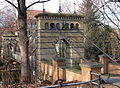
| The Inselwall with St. Andreas in the background | |
| Basic data | |
| place | Braunschweig |
| District | Neustadt |
| Created | from 1803 |
| Hist. Names | Petrithor Promenade, Island Promenade |
| Connecting roads | Petritorwall, At the new Petritore; Bammelsburger Strasse, Am Gaußberg |
| Cross streets | Schubertstrasse |
| Buildings | Johannes Selenka School, Villa Löbbecke , Villa Bierbaum (formerly) |
| use | |
| User groups | Pedestrian traffic , bicycle traffic , car traffic |
| Technical specifications | |
| Street length | 700 m |
The Inselwall (formerly Petrithor-Promenade, then Insel-Promenade ) is a street in Braunschweig . It leads along the southern edge of the Inselwallpark .
history
From 1803 the fortifications of the Braunschweiger Okerinsel were converted into parks under the direction of Peter Joseph Krahe . On the inside of these ramparts, promenades were built, the names of which today end in "wall". This work began in the northwest of the former Okerinsel precincts Neustadt , in the area of today's island Walls. The Bammelsburg located there was also demolished around 1830. The street was built as a promenade with a winding route, while the later promenades were mostly straight. It was called the "Island Promenade". As one of two buildings, a house was erected for a shoemaker at today's address Inselwall 1 from 1804; it no longer exists today. From 1805 the Villa Bierbaum was built in the east of today's Inselwallpark, which was the birthplace of the writer Ricarda Huch in 1864 and was damaged in the Second World War and later demolished. For a long time it was number 16. The street was named after "Bierbaums Insel", a former ravelin in the west of the park. In 1845 it was still largely undeveloped.
The street was built on the south side first with garden houses , later with town villas . In the middle part, several multi-storey houses were built on the north side. On the former Ravelin was 1880-81, designed by Constantin Uhde the Villa Löbbecke built, which also belongs to the Inselwall. The "Villa Girsewald" in Inselwall was also designed by Uhde and was located across from Villa Löbbecke. Almost all houses were destroyed during World War II and later replaced by simpler houses. In 1956, Hannes Westermann received the “Peter Joseph Krahe Prize” for his design for Inselwall 6, a two-storey residential building that was built in 1953.
Plant and traffic
The island wall is around 700 meters long and has several curves. In the southwest it merges into the Petritorwall , in the northeast it joins Bammelsburger Straße and Am Gaußberg. The Schubertstraße near the Gaußberg branches off from the Inselwall. The Inselwall crosses the Neustadtmühlengraben and is connected by a stone staircase to the southern streets of Okerstraße and An der Neustadtmühle, which meet there. In the eastern section, the Inselwall runs parallel to the Bosselgraben . The road has two lanes and is used for parking on both sides. There are numerous large deciduous trees along the road, especially plane trees . Several footpaths branch off from the island wall into the park. Some paths in the western part lead to the weir bridge or to the Rosental bridge, two pedestrian bridges that lead near the island wall over the western Okerum flood ditch into the western ring area.
Most houses are multi-story houses with gardens. Some of them also serve commercial purposes. There are several apartment buildings to the west of the street. In the eastern section of the street, beyond the Bosselgraben, is the Johannes Selenka School, which is number 1 a. The house numbers were assigned according to the horseshoe numbering system, as is customary in the Braunschweig core city . House number 1 is on the stairs to Okerstraße / An der Neustadtmühle. From there, the houses in the west are counted to 10, three houses having the number 3 (3, 3 a, 3 b) and two houses the number 10. The number 11 is assigned to the Villa Löbbecke. The four other houses north of the street are numbered 12 to 15. To the east of the street is the Inselwall pumping station . Thus the north side is largely undeveloped; the Inselwallpark usually extends to the street. The Inselwall was rededicated as a bicycle road in 2011 and thus belongs to a system of bicycle roads along the Braunschweiger Wallring.
The tram serves the “Inselwall” stop. However, it is located in the street "Am neue Petritore" near the western end of the island wall.
Buildings
The Johannes Selenka School is a vocational school for numerous technical professions. It was built in 1928/33 as a “boys' vocational school”. The school has existed since 1855. At that time it was founded as a "training school for craftsmen" who were taught at various locations in Braunschweig. In 2005 it was given its current name, which is reminiscent of the Braunschweig master bookbinder Johannes Selenka .
The Villa Löbbecke was built between 1880 and 1881 in the neo-renaissance style for the banker Alfred Löbbecke . During the time of National Socialism it served at times as the Braunschweig headquarters of the SS . In 1944 it was destroyed by a bomb attack. From 1968 to 2008 the Technical University of Braunschweig used the villa as a guest house; since 2011 it has served as an office building.
Impressions
| Island wall | |
|---|---|
The Inselwall ("Insel-Promenade") on a map of the city of Braunschweig from 1899
|

.jpg)

The eastern section, on the right an entrance to Inselwallpark

Western section of the island wall

Main entrance of the Johannes Selenka School with a bridge over the Bosselgraben

Villa Löbbecke seen from Inselwall, in the foreground the Bammelsburger Teich
Rosentalbrücke at the west end of the Inselwall

Weir bridge

View from the Gaußberg in southwestern direction onto the Inselwall (rear view of the Gauß monument ).


.JPG)
.JPG)
.JPG)
literature
- Jürgen Hodemacher: Braunschweig's streets - their names and their stories. Volume 1: Inner City. Elm-Verlag, Cremlingen 1995, ISBN 3-927060-11-9 .
- Wolfgang Kimpflinger: Monument topography Federal Republic of Germany , architectural monuments in Lower Saxony. Volume 1.1 .: City of Braunschweig. Part 1. Hameln 1993, ISBN 3-87585-252-4 .
- Simon Paulus, Ulrich Knufinke: The Braunschweiger Wallring. Guide to the history and architecture of a cultural and historical monument. With photographs by Heinz Kudalla. Appelhans, Braunschweig 2011, ISBN 978-3-941737-59-4 .
- Heinz-Joachim Tute, Marcus Köhler: Garden art in Braunschweig: from the princely gardens of the Baroque to the public park of the Wilhelminian era. In: Braunschweiger workpieces. Series A Volume 28 / the whole series Volume 76, Waisenhaus-Druckerei, Braunschweig 1989, ISBN 3-87884-037-3 .
Web links
Individual evidence
- ↑ Kai-Uwe Grahmann among others: Gardens and Parks - Braunschweiger Land. Arnhold & Kotyrba, Braunschweig 2012, ISBN 978-3-942712-19-4 , p. 34.
- ^ Elmar Arnhold, Sándor Kotyrba: Classicism in Braunschweig. Arnhold & Kotyrba, Braunschweig 2010, ISBN 978-3-942712-09-5 , p. 5 (map of the city around 1845)
- ↑ Simon Paulus, Ulrich Knufinke: The Braunschweiger Wallring. Guide to the history and architecture of a cultural and historical monument. With photographs by Heinz Kudalla. Appelhans, Braunschweig 2011, ISBN 978-3-941737-59-4 , p. 91.
- ↑ Luitgard Camerer, Manfred Garzmann, Wolf-Dieter Schuegraf, Norman-Mathias Pingel (eds.): Braunschweiger Stadtlexikon. Supplementary volume. Meyer, Braunschweig 1996, ISBN 3-926701-30-7 , p. 137.
- ↑ Report at localxxl.com ( Memento from March 4, 2016 in the Internet Archive )
- ↑ Luitgard Camerer, Manfred Garzmann, Wolf-Dieter Schuegraf, Norman-Mathias Pingel (eds.): Braunschweiger Stadtlexikon. Supplementary volume. Meyer, Braunschweig 1996, ISBN 3-926701-30-7 , p. 21.
- ^ Festschrift for the 150th anniversary of the Johannes Selenka School. Braunschweig 2005
Coordinates: 52 ° 16 ′ 11 ″ N , 10 ° 31 ′ 2 ″ E
