
Gaußberg (Braunschweig)
.JPG)
The Gaußberg is a small green area of 1.38 hectares , which forms an elevation on the north-north-western edge of the soft patch Hagen in Braunschweig . It was created in 1831 as a result of the razing of the bastionary fortifications of the city of Braunschweig at the beginning of the 19th century by Peter Joseph Krahe .
history

Braunschweig had been a heavily fortified city since the late Middle Ages . After the loss of independence in 1671, plans by the Brunswick fortress construction director and major general Johann Caspar von Völcker began to expand the fortifications . On the inside of the Okerring enclosing the city there were 16 bulwarks , including the “Rudolfsbollwerk”, named after the Guelph Duke Rudolf August von Braunschweig-Wolfenbüttel . A windmill had stood on the bulwark since 1703 .
When such defensive structures gradually became ineffective in view of changes in warfare and weapon technology , from 1803 Braunschweig began to convert these structures and make them available to the population. The main planner of this work, which was not completed until 1835, was the head of construction in the Duchy of Braunschweig, Peter Joseph Krahe.
The baroque Rudolfsbulwerk, west of the turnaround gate , was redesigned as the last defensive work of the city in the final phase of this so-called " wall modeling " and the " island wall promenade " was laid out. For this purpose, the old anatomy building of the Anatomical-Surgical Institute of the Collegium Carolinum had to be demolished after 1824 , which was located nearby and which gave its name to the elevation until the inauguration of the Gauss monument in 1880, which until then was called "Anatomieberg" . For the redesign, Krahe had a few meters of earth poured in and a viewing platform with a ring-shaped footpath created. The hill sloping north to the Oker was planted with numerous chestnut trees and copper beeches , which shape its appearance to this day. The hill is at the transition from the Inselwall to the Wendentorwall . The small park was completed in 1831.
.JPG)
From 1862 on, six residential buildings were gradually built on the (today so named) street "Am Gaußberg". At the southern foot of the hill, in honor of the mathematician Carl Friedrich Gauß, who was born in Braunschweig, his larger than life statue was erected in 1880. The design came from Fritz Schaper and was executed in bronze by Hermann Heinrich Howaldt . Gauss had used the hill of the original bulwark for surveying purposes based on the Gauß-Krüger coordinate system he had developed . Some of the surveying stones used by Gauss are still visible today.
In 1999 work began on reconstructing the hill in terms of garden conservation. In this context, the monument was given back its all-round wrought-iron grille, which could be reconstructed from historical photos.
On the eastern slope of the Gaußberg, a stone column with an iron cross on top was erected in 1925 as a memorial for those of the Reserve Infantry Regiment 273 who fell in World War I.
Impressions

The anatomy building

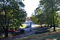
Up on the Gaußberg

View towards Inselwall, rear view of the Gauss monument

Memorial to the fallen of Reserve Infantry Regiment 273
View towards the Wendentorwall in the east

.JPG)
.JPG)
.jpg)
.JPG)
literature
- Camerer, Garzmann, Schuegraf, Pingel: Braunschweiger Stadtlexikon , Braunschweig 1992, ISBN 3-926701-14-5
- Jürgen Hodemacher : Braunschweigs streets - their names and their stories, Volume 1: Innenstadt , Cremlingen 1995, ISBN 3-927060-11-9
- Wolfgang Kimpflinger: Monument topography Federal Republic of Germany . Architectural monuments in Lower Saxony , Volume 1.1 .: City of Braunschweig , Part 1, Hameln 1993, ISBN 3-87585-252-4
- Simon Paulus, Ulrich Knufinke: The Braunschweiger Wallring. Guide to the history and architecture of a cultural and historical monument , with photographs by Heinz Kudalla, Appelhans Verlag, Braunschweig 2011, ISBN 978-3-941737-59-4
- Heinz-Joachim Tute, Marcus Köhler: Garden art in Braunschweig: from the princely gardens of the Baroque to the Bürgerpark of the Wilhelminian era , In: Braunschweiger Werkstücke , Series A Volume 28 / the whole series Volume 76, Waisenhaus-Druckerei GmbH, Braunschweig 1989
Individual evidence
- ↑ a b Wolfgang Kimpflinger: Monument topography Federal Republic of Germany. Monuments in Lower Saxony , Volume 1.1 .: City of Braunschweig , Part 1, p. 201
- ↑ Gerd Spies (Ed.): Braunschweig - The image of the city in 900 years. History and Views , Volume 2 Cityscape , Braunschweig 1985, p. 59
- ↑ Norman-Mathias Pingel: Gaußberg , In: Camerer, Garzmann, Schuegraf, Pingel: Braunschweiger Stadtlexikon , p. 81
- ↑ Karl-Rudolf Döhnel: The Anatomical and Surgical Institute in Braunschweig 1750–1869 , In: Braunschweiger Werkstücke , publications from the archive, library and museum of the city, Volume 19, Waisenhaus-Buchdruckerei and Verlag, Braunschweig 1957, pp. 30f
- ↑ Wolfgang Kimpflinger: Monument topography Federal Republic of Germany. Architectural monuments in Lower Saxony , Volume 1.1 .: City of Braunschweig , Part 1, p. 202
Web links
- Website about the Gaußberg
- Information about the Gaußberg (PDF file)
- Gauss monument in the Lower Saxony Monument Atlas
.JPG)
Arboretum | Medicinal Plant Garden | Botanical garden | Bürgerpark | Franz's field | Gaussberg | Green area at the Westbahnhof | Heidbergsee and Park | Hermann-Löns-Park | Inselwallpark | Kennel | Kiryat Tivon Park | Monastery garden | Monastery park | Lion Wall | Museum park | North Park | Riddagshausen nature reserve | Oil Persee | Prinz-Albrecht-Park and Nussberg | Ring track | Richmond Park | School and community garden | City Park | South Seas area | Südstadtpark | Theater park | Vieweg's garden | West Park
Planned: Park on Münchenstrasse | Formerly: Castle Park
Coordinates: 52 ° 16 ′ 20.7 ″ N , 10 ° 31 ′ 23.7 ″ E