Südstadt (Braunschweig)
|
Südstadt
City of Braunschweig
|
|
|---|---|
| Coordinates: 52 ° 14 ′ 5 ″ N , 10 ° 33 ′ 37 ″ E | |
| Residents : | 2814 (December 31, 2015) |
| Postal code : | 38126 |
| Area code : | 0531 |
|
The Südstadt in Braunschweig,
district of Südstadt-Rautheim-Mascherode |
|
|
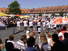
Christmas market with a view of the "Roxy"
|
|
The Südstadt is a district of Braunschweig in the southeastern district of Südstadt-Rautheim-Mascherode .
history
Wolfshagen desert
Until the 16th century, a large part of today's settlement was covered with forest, which belonged to the large forest area of Siechenholz , Lindenberg , Mastbruch and Nussberg .
In 1172 the Wolfshagen desert , which was probably only cleared from the large forest area in the 12th century, is documented in the Steterburg annals . The settlement was located on a small, but water-rich stream, which flowed on through the swamp area of Heidberg , Rothe Wiese and Rothe Teich to the Oker . The hill on which the Salzdahlumer Straße Clinic is located today offered protection from cold north winds. According to broken fragments from the 13th to 15th centuries, the settlement existed until then and comprised three or four courtyards. The settlement belonged to the Steterburg monastery . As a result of purchase and exchange, there were various landlords, even after the settlement had become desolate. Most of the fields (approx. 600 acres ) in the desert went to Rautheim and a smaller part to Mascherode . After the Reformation , the interest went to the University of Helmstedt , the tithe from Rautheim went to the Riddagshausen monastery , and that from Mascherode to the Kruger from Mascherode.
Military use and hospital
On part of the site that came to Braunschweig at the end of the 19th century , the new "Great Parade Grounds" was laid out in 1889 with an area of 116 hectares and 67.72 acres . The community of Rautheim and the large orphanage BMV also gave up land. The artillery set up powder magazines as early as 1839 and 1868. In her Braunschweiger Bilderbogen Lehne mentions a powder tower on the way to Mascherode.
On the parade ground on October 13, 1912 ends with the "Hansa" the first time an airship in Braunschweig.
From 1937 to 1939, the air force hospital (now the Salzdahlumer Straße Clinic) was built, located next to allotments and a sports hotel on the site of the desert.
The settlement
The German Labor Front under Julius Schulte-Frohlinde planned the settlement for initially 2,500 people who were to be accommodated in 600 residential units. In the center of the settlement, a community house was to be built next to the market square, which was to consciously assume the role of the church up to now. In 1938 the plans were expanded to include around 5,500 residents. As a teaching settlement for architecture students, it comprised various types of construction: single and multi-family houses, semi-detached and terraced houses.
The settlement was built between 1936 and 1939 as a National Socialist model settlement, initially planned under the name of Lehrsiedlung Mascherode ("four-year plan settlement"), then alternately referred to as Südstadtsiedlung (am) Mascheroder Holz , Siedlung Mascheroder Holz , Südstadtsiedlung Mascherode and Settlement Mascherode .
On February 29, 1956, the City Council of Braunschweig decided to rename the Mascherode settlement to Braunschweig-Südstadt .
Initially, the new development areas Heidberg and Melverode were also counted as part of the southern part of the city, on March 26, 1969 the division into the current individual districts of Melverode, Heidberg and southern part took place.
In the course of the regional reform and the associated dissolution of the Braunschweig district (1974) and the formation of urban districts (1981), the southern part of the city was merged with Rautheim to form the district of 211 Südstadt-Rautheim . Through the voluntary merger of this district with Mascherode, today's district of Südstadt-Rautheim-Mascherode was created in 2001 .
Boundaries and structure of the settlement
The boundaries of the settlement can be determined using the statistical district of Südstadt. The Möncheweg forms the clear border to Rautheim, to the east of which the settlement Rautheim-Südwest is currently being built. To the Heidberg, Salzdahlumer Straße is both the settlement and the city district boundary. The border to Mascherode runs south of the Mascheroder Holz.
The green belt between Südstadt and Lindenbergsiedlung consisting of allotments and golf club as well as the municipal clinic in Salzdahlumer Straße and the school center (vocational schools, miller school) belong to the statistical district and are hereby treated. The A 39 forms the border with the Viewegsgarten-Bebelhof district .
Welfenplatz and "Roxy"
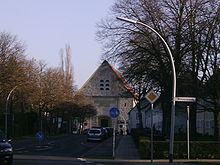
The center of the settlement is Welfenplatz with the community house, which is also called "Roxy" after its temporary use as a cinema. The square was originally designed primarily as a parade ground for National Socialist organizations, and the community center served similar purposes. The topping-out ceremony was celebrated on July 27, 1937 in the presence of the then Prime Minister Dietrich Klagges , and on April 30, 1939 the building was opened.
The building consists of a party house, which is deliberately reminiscent of a church, and a side wing (administration wing) with an arcade. The German Labor Front (DAF), the NSDAP and the Hitler Youth were housed in the side wing . The design comes from Albert Speer . The main building was built from Elm limestone . The side wing and the other houses on Welfenplatz (then Robert-Ley- Platz) were built as half-timbered houses. The roofs were covered uniformly.
At the end of the war, the building was initially confiscated by the Americans and used as a command post. After an interim use as a venue for boxing matches, the "Roxy-Film-Casino" was opened on December 2nd, 1949 with the film The Great Miss with Gisèle Pascal and Ray Ventura . The cinema was one of the largest in Braunschweig with 630 seats and also had a stage for theater performances. The cinema was named after the building. After the general decline in the number of visitors in the cinemas, this was converted into a supermarket in 1963. Other rooms were initially only used by the school and the Südstadt associations (including Altenkreis, youth groups). In 1976 an open youth facility was opened through an initiative of several people from the southern part of the city. The facility was later taken over by the city and celebrated its 30th anniversary in 2006 with a 30-hour program.
As early as 1946, the upper part of the side wing was used as a kindergarten; After the construction of the kindergarten on Nietzschestrasse, the daycare center was initially housed there, and today it serves as an educational facility for the city’s day-care centers. From 1944 there was a branch of the public library in the lower area. A police station has been located there since 1956, and since 1993 the “Neighborhood Aid Southeast”.
In 1988 the state of Lower Saxony , which had owned the Roxy since 1953, sold the building and parts of Welfenplatz to a private company. The sale resulted in various changes in use. The library had to close after 44 years. The youth center, which previously consisted of just one room on the ground floor, was moved to the first floor and expanded in the process. Today a supermarket uses the ground floor.
"Small market" and Hermann-Löns-Park
In addition to Welfenplatz with the Roxy community center in the middle of the settlement, there is a small market square on Heidehöhe, which bears the unofficial name “Kleiner Markt”. In the immediate vicinity is the Hermann-Löns-Park, inaugurated on May 31, 1953, with a playground and football field. During the war there was a fire fighting pond on the grounds of the football field. Another was on Retemeyerstrasse across from the school.
School and kindergarten
The school was built according to plans by the German Labor Front in 1936 and 1937 and was inaugurated on May 7, 1938 as the “ Primary School Südstadtsiedlung Mascheroder Holz”. The school was badly damaged and partly destroyed by bomb attacks. After the end of the occupation by American troops, the school was reopened as the “Mascheroder Holz elementary school” on October 1, 1945; today it serves as a primary school .
In 1954 an after-school care center was set up on the school premises. From 1946 the day care center was located in the side wing of the Roxy. In the meantime a new building has been erected on or on the school premises. The former daycare center is now the further training facility for the municipal day-care centers.
From “Lager Griegstraße” to Südstadtpark
In 1942 a foreign labor camp was built on Griegstrasse (then Robert-Ley- Strasse). After the war it was used as a refugee camp. Of the buildings there is only a former barrack, which was renovated by the Südstadt community and is used by them and their affiliated associations.
The square next to this building has been used as a fairground for the Volks- und Schützenfest since 2003 and as a boulodrome since 2004 .
The park was initially called Heidbergpark Ost. By resolution of the administrative committee of the city of Braunschweig on November 20, 2007, the park was renamed Südstadtpark. Since 2006 there is also a skating facility in the park. The Heidbergsee is in the immediate vicinity .
Religions
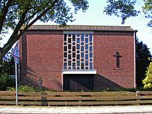
The Catholic Church of St. Heinrich , named after the Emperor Heinrich II (HRR) , is located on the southeast corner of the district (Nietzschestraße 1a). It was consecrated in 1960 and has belonged to the parish of St. Bernward in the Heidberg district since 2006 .
The Evangelical Lutheran Church of St. Markus , named after the Evangelist Markus , was built in 1998/99 (Heidehöhe 28). Before that (from 1953) the services took place in the church hall of the adjacent parish hall. Your parish has been part of the Parish Association of Braunschweig South of the Braunschweig Provost since 2014 .
Regular events
The Bürgergemeinschaft Südstadt and its affiliated associations organize several festivals every year. The folk and rifle festival traditionally takes place at the end of or after the summer vacation. The festival used to take place on Welfenplatz, but in 2003 it was moved to the new festival square on Griegstrasse.
On the second Advent, the Südstadt Christmas market takes place on Welfenplatz.
In 2006, the Südstadt Citizens' Breakfast took place for the first time.
coat of arms
The coat of arms shows a silver house on a red shield.
The building symbolizes the “Roxy” community center with its eventful history. The choice of symbol for the settlement was controversial due to the National Socialist use of the premises. The red and white coloring stands for belonging to the city of Braunschweig, which also has this in the coat of arms. The coat of arms is still very young, a first draft was rejected and had to be revised.
The new draft was adopted on August 7, 2009 by the citizens' assembly (neighborhood meeting) of the southern city.
literature
- Wilhelm Lehmann: 50 years of the Mascheroder Holz / Südstadt settlement 1936–1986. Bürgergemeinschaft Südstadt, Braunschweig 1986.
- Wilhelm Lehmann: The community house (Roxy) in the southern part of Braunschweig. Published by Wolf-Dieter Schuegraf on behalf of the city of Braunschweig . City Library, Braunschweig 1993. ( City Archives and City Library Braunschweig Kleine Schriften 26, ZDB -ID 2523105-4 ).
Web links
Individual evidence
- ↑ Population statistics on braunschweig.de
- ↑ a b c d Wilhelm Lehmann: "Die Wüstung Wolfhagen". in: Braunschweigischer Kalender 2002. S. 86f.
- ^ AH Lehne: Braunschweiger Bilderbogen from 1880. Braunschweig 1941; 1949; P. 49.
- ↑ Map of the statistical districts ( memento of the original from September 27, 2007 in the Internet Archive ) Info: The archive link was inserted automatically and has not yet been checked. Please check the original and archive link according to the instructions and then remove this notice. on braunschweig.de
- ↑ Rautheim-Südwest construction area ( Memento of the original from July 15, 2007 in the Internet Archive ) Info: The archive link was automatically inserted and not yet checked. Please check the original and archive link according to the instructions and then remove this notice. on braunschweig.de
- ↑ Südstadtchronik from p. 42 with extensive image material on bs-sued.de
- ^ A b Wilhelm Lehmann: "The community house (Roxy) in the southern part of Braunschweig".
- ↑ Südstadtchronik p. 47. on bs-sued.de
- ↑ Südstadtchronik p. 39. on bs-sued.de
- ^ A b c Wilhelm Lehmann: 50 years of the Mascheroder Holz / Südstadt settlement 1936–1986. Braunschweig 1986.
- ↑ Südstadtchronik p. 57. on bs-sued.de
- ↑ Announcement by the city administration to rename a green area (Südstadtpark) ( Memento of the original from December 7, 2008 in the Internet Archive ) Info: The archive link was inserted automatically and has not yet been checked. Please check the original and archive link according to the instructions and then remove this notice. on braunschweig.de
- ↑ Bz report on BS-Süd.de ( memento of the original from September 27, 2007 in the Internet Archive ) Info: The archive link was inserted automatically and has not yet been checked. Please check the original and archive link according to the instructions and then remove this notice.
- ↑ Clubs / associations and non-profit societies on the website of the Bürgergemeinschaft Südstadt with additional links on bs-sued.de
- ↑ Roxy approved ( page no longer available , search in web archives ) Info: The link was automatically marked as defective. Please check the link according to the instructions and then remove this notice. on bs-sued.de
- ↑ Draft (PDF; 2.7 MB) on klaus-peter-bachmann.de or objection to the design of the coat of arms from 2008 ( memento of the original from January 6, 2016 in the Internet Archive ) Info: The archive link was inserted automatically and has not yet been checked. Please check the original and archive link according to the instructions and then remove this notice. (PDF; 53 kB) at m.braunschweig.de
- ↑ Coat of arms accepted (PDF; 1.6 MB) on spd-mascherode.de


