Weststadt (Braunschweig)
|
West town
City of Braunschweig
|
|
|---|---|
| Coordinates: 52 ° 14 ′ 56 ″ N , 10 ° 29 ′ 10 ″ E | |
| Height : | 78–96 m above sea level NHN |
| Residents : | 23,443 (Dec. 31, 2015) |
| Postal code : | 38120 |
| Area code : | 0531 |
|
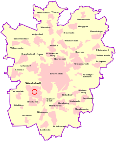
Location of the Weststadt in Braunschweig
|
|
|
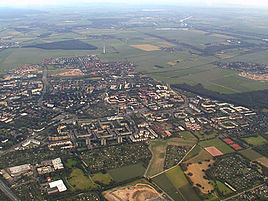
Weststadt from the air towards the south (2003)
|
|
The Weststadt is a district and urban district of Braunschweig and has the official number 221 (until 2006 No. 311) and the postcode 38120. The Weststadt is a young district in the south-west of Braunschweig with five neighborhoods and a central area with public facilities, which dates from the 1960s Years until the 1980s. The site, which is planned as a green part of the city with green spaces close to the apartment, is surrounded by parks, allotment gardens and forests and is located directly on the federal motorway 391, which runs past to the east . Weststadt is one of the rare place names that are used with articles . The district is sometimes referred to as Braunschweig-West and abbreviated as BS-West .
The development of the district consists largely of multi-storey apartment buildings, with single-family houses and terraced houses on the outskirts.
geography
The Weststadt is located in the southwest of the city, about four kilometers as the crow flies from the center of Braunschweig. Neighboring districts of the Weststadt are in the west Timmerlah , in the south Broitzem , in the southeast the garden city and in the east it borders on the western ring area . In the north is the Westpark (part of the city district Weststadt) and in the west the Timmerlaher Busch. The Weststadt lies mainly on very flat terrain and on slight hills such as the vineyard. The urbanization is limited in the west by the Timmerlaher Busch and the Broitzemer Holz bordering on the south, the railway line to Hildesheim in the south, the Alte Frankfurter Strasse in the east and the Madamenweg in the north.
history
prehistory
Around 1900 the area of today's Weststadt was almost completely undeveloped. It mainly consisted of arable land, meadows and clay pits. On Broitzemer Straße (a former trade route, today Münchenstraße, Traunstraße, Lichtenberger Straße) there were isolated farms, a gardening shop and the “Zur Rothenburg” inn. The Rothenburg was originally one of Braunschweig's Landwehr towers and is still used as a restaurant today. Numerous brickworks were located in the area of today's Westpark.
In 1909 the allotment garden association Westend was founded, whose gardens still exist today and have been integrated into the growing park landscape and residential developments. In 1916 the Broitzem airfield was built on a large part of the southeastern meadows and arable land. From 1919 to 1920 the small airport was connected to the German route network. Afterwards allotment gardens were created on parts of the airfield. In 1924 the airport was reopened shortly afterwards with an extended runway. Flughafen GmbH was founded in 1926.
In 1928 the first larger residential areas were built in the Weststadt area. On Broitzemer Straße (today Traunstraße) opposite the allotment garden association Westend, the "Freiland settlement" was built with a few single and two-family houses. Six more buildings were erected further east in 1940. They served the Allies as accommodation from 1945 onwards .
In 1929 the German Aviation School set up its headquarters at Broitzem Airport. During the National Socialist era, the airport became a purely military airfield; a new airport was built in Waggum in the northeast for civil flights . While the northern part of the area of today's Weststadt already belonged to Braunschweig, the southern part finally came to the city area on April 1, 1934. This step was necessary so that the entire area of the airfield was in the Braunschweig city area. In 1935 the Broitzem barracks was built at Broitzem airfield. On the opposite side of the street from Münchenstrasse there are still the former officers' houses of the barracks, which are now used as rental apartments and some social facilities. The last widow of these officers lived in one of these houses until the 2000s. After the end of the war, refugees were housed in the barracks.
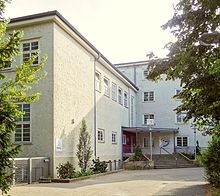
The airport buildings were partially blown up, other buildings were used until the 1980s and then removed. In May 1946, the airfield was finally converted back to farmland. The remaining buildings of the airport and the barracks were later included in the Weststadt, they were moved into after their renovation in the 1980s. An aircraft hangar was preserved until August 2006 and has been used by a beverage market and other shops in recent years; the flying school building is now used as the Weststadt community center and as a technical college. The first Weststadt youth center, which was named “Youth Center White Rose” in memory of the siblings Hans and Sophie Scholl , was also set up here. Since 1991 it has been redesigned and converted into a kids' and teen's club. Here classic after-school care is combined with open work with children and young people. The barracks buildings are used by various institutions, including a. until its dissolution by the former district government .
Shortly after the conversion of the airfield into arable land, a new industrial estate was built on the Lehmanger and Möhlkamp, with mainly large gardeners' farms, the "Gärtnerhof-Siedlung". Some of the nurseries became large nurseries. In the meantime none of the nurseries has remained.
In the post-war period there was also a housing shortage in Braunschweig, with the construction of apartments in Heidberg and Melverode the housing demand could not be adequately covered. From 1960 onwards, the Weststadt was built on Braunschweig's southwestern city limits. It was the fifth largest building area in what was then the Federal Republic of Germany and was mainly built from 1960 to the 1980s. It should offer apartments for 30,000 residents. The first buildings were built in the "Rothenburg settlement" and on the streets Am Queckenberg, Im Wasserkamp and An den Gärtnerhöfen. The year 1960 is therefore considered to be the date of origin of the Weststadt; the last major construction work finally took place in the mid-1990s.
Planning the Weststadt
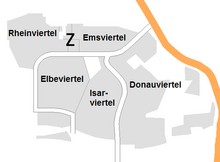
The Weststadt is a planned city in which the garden city idea was implemented. It is divided into five so-called neighborhoods, the I. (also Rothenburg), the II., The III. (also Rheinring area), the IV. and V neighborhood (also Danube district) and area Z, in which the public facilities are located. Every neighborhood - with the exception of the fourth neighborhood, which shares a shopping center with the second neighborhood - has its own shopping center. The Weststadt is also designed like a satellite town , which is reflected in the street structure, among other things. Coming from the city center of Braunschweig, there is a main street (Münchenstraße), which then branches into two more streets (Elbestraße and Donaustraße) in the western part of the city. These form the most important traffic axes within the Weststadt. The entire transport network is designed in such a way that the traffic flows towards these two main axes and is thus directed to the city center. This is similar to the course of small rivers that gradually flow into a larger river. With a few exceptions, these streets bear the name of German rivers, whereby attention was also paid to the geographical location of the rivers. For example, you can find the Isar, Inn and Lechstraße on Donaustraße, just as the Isar, Inn and Lech are tributaries of the Danube . Other street names are derived from field names and personal names . A few other streets and the few streets that were newly built in the 1990s have place names. In the south, the western part of the city is divided into two parts by a green strip, the Danube Park, which follows the course of a high-voltage line. Characteristic for the district are the large number of path connections for pedestrians and cyclists. A striking feature are the three 43 meter high, identical high-rise buildings on Emsstrasse, which can be seen from afar.
Construction of the west city
First of all, the construction of the 1st and 5th neighborhoods began. At the same time, the planning for the entire district began. The second and fourth neighborhoods were added at the beginning of the 1970s; the last was in the mid-1970s with the III. Neighborhood started.
Isar and Danube districts
Both neighborhoods emerged from 1960. The first neighborhood was almost complete by the end of the 1960s. When building, houses in row and comb construction were preferred. This is where the first shopping opportunities arose, initially in a barrack on Queckenberg, then from 1963 on Donaustraße, later on from 1965 further shops followed on Illerstraße. The barracks later served as a provisional church for the Protestant community from 1966 to 1969 and for the Catholic community from 1969 to 1972. The makeshift building was eventually used as a youth center. The sports field of the former barracks in the current fifth neighborhood made possible the first opportunities for sporting activities; it was mainly used for soccer games. In 1963 the first elementary school was opened in the district, in 1964 the first kindergarten in Weststadt on Donaustraße.
Elbe district
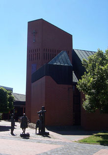
It forms the southwestern part of the western city. From 1974 the roofed central shopping center of Weststadt was built here with a market place. Immediately next to it, the Protestant Emmaus Church was built in 1983. Mainly there are houses with flat roofs, the facades of which are clad with red panels.
A weekly market has been held on the market square every Thursday since 1977.
Rheinviertel
The Rheinviertel is the III. Neighborhood of the west city, however it was started last. In the III. According to the plans, large and higher apartment blocks with eleven floors should actually be built in the neighborhood. However, the development plan was not approved by the supervisory authority. One did not want to repeat the monotonous construction of the fourth neighborhood and high-rise buildings gradually fell into disrepute for promoting the anonymity of the residents. Construction of the last neighborhood began in the mid-1970s, and the shopping center was built at the same time. The area left free for a Catholic parish was never built on with a church building. In 1996 it was given to the St. Nikolaus children's home. Today the neighborhood is named after the main street, the Rheinring, Rheinringgebiet. In the north-western part mainly single-family houses were built.
Emsviertel
The fourth neighborhood is the northeastern part of the Weststadt around Emsstrasse. The development plan was developed in 1971/72. The construction company Neue Heimat was responsible . This is also where the three 43 meter high skyscrapers were built; originally even five were to be built. The architecture of this area received a lot of criticism.
The streets are mainly named after the tributaries of the Ems.
Area Z
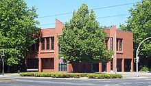
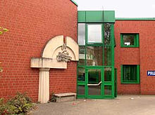
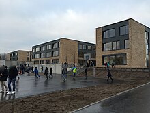
The "Z" stands for central area or center. A large number of public institutions are concentrated in this area of Weststadt. An integrated comprehensive school , the Wilhelm-Bracke-Gesamtschule (1974–2015), a public library (1975–2015), a youth center ("rotation"; 1984), a police station (1987) have been built around Alsterplatz since the 1970s. , a kindergarten (1992) and a primary school (Rheinring primary school; 1999). The Wilhelm Bracke Comprehensive School and the library moved into a new building on Westpark in January 2015. A swimming pool and a building for a high school were also planned. Although these projects have not been rejected, they cannot be implemented in the near future, mainly for financial reasons. Reserved areas are available. The upper school level is currently housed in the new IGS building.
VI. Neighborhood?
In the zoning plan of the city of Braunschweig (since 1974), further residential areas were allocated to the west city in the southwest. A new building area could arise there in the future, which will expand Weststadt with additional living space.
Further development
In 1972 the district was officially named Weststadt.
In 2005 the first neighborhood meeting point was founded in Weststadt, the Weststadt meeting point (later meeting point Am Queckenberg). The second meeting point opened on December 6, 2007 with the meeting point in Saalestrasse. In August 2008, the city of Braunschweig and several building cooperatives represented in Weststadt founded the Weststadt District Development Association. In 2008, it took over the sponsorship of the meeting points and set up a district management for the district.
Since 2007 the Weststadt has had its own coat of arms, reminiscent of the Westpark (green coat of arms with a white tree in the middle) and the street names, most of which get their name from rivers (white river under the tree).
In order to further develop the Danube Quarter, Emsviertel, Rhine Quarter and parts of the Elbe Quarter, the city of Braunschweig set up a concept for the area known as Northern West City in the 2000s and endeavored to receive funding through the funding programs Urban Redevelopment West and Social City. On July 8, 2008, the application was approved by the City Council of Braunschweig. However, since this funding was not awarded to the city, the concepts were limited to parts of the original entire application. First, the Ilmweg sub-area (sub-area I) was included. The planning for the Rheinviertel was completely stopped and the Emsviertel was postponed. Funding for the Donauviertel was continued and should be implemented through other funding programs. The rehabilitation of the Ilmweg began in 2009 and was completed in summer 2019.
On the occasion of the 50th anniversary of the founding of Weststadt in 2010, citizens were called upon to find names for the five neighborhoods of Weststadt by means of a competition. The result of the competition was announced on May 30, 2010 during the second citizens' brunch. The obvious suggested names for the neighborhoods were Isarviertel (I), Elbeviertel (II), Rheinviertel (III), Emsviertel (IV) and Donauviertel (V). On June 24, 2010, the administrative committee of the city of Braunschweig decided on these names, these names were largely new, only the name Donauviertel was in colloquial use long before. The terms Rothenburg and Rheinring area were also used. When the neighborhoods were named, the former barracks area was also reassigned to the Danube Quarter.
The level of cold rents in Braunschweig Weststadt is currently at the same level as in all other outlying districts of Braunschweig (as of 2018). Only the inner city districts and the city district Wabe-Schunter-Beberbach are higher in terms of costs.
In 2016, the Danube district was included in the social city development program. One of the first projects in the Danube Quarter is the demolition and refurbishment of houses in the street An den Gärtnerhöfen from 2021, for which a large proportion of the residents have to leave their apartments.
The Elbeviertel neighborhood center (or Weststadt neighborhood center) was opened in September 2017 . With the demolition of the old Wilhelm-Bracke-Gesamtschule, a new residential quarter was created on Alsterplatz ( residential quarter on Alsterplatz ), and the new apartments were occupied from 2019.
Currently (2020) the Rheinring / Elbestraße shopping center is being demolished and rebuilt. There are also plans and requests for the construction of a train stop on Donaustraße, the construction of a fire station and a cemetery for the district that could be built between Am Lehmanger and the Autobahn.
Demographics and religion
36.2% of Weststadt residents are Protestant and 25.8% Catholic. Both the proportion of residents under the age of 20 and those aged 40 and over is higher than the average for the city of Braunschweig. The proportion of foreign residents is 8.8%, that of the entire city of Braunschweig 7.6%. Of the approximately 24,700 inhabitants of Weststadt, around 11,500 are male and around 13,200 are female. 4806 Weststadt residents live in the statistical district of Hermannshöhe, 9749 in the Rothenburg district and 8861 in the Weinberg district.
With 3430 inhabitants per square kilometer, the Weststadt district is the fourth most densely populated district of Braunschweig. However, as Westpark, which is poorly populated, was included in the city district, the population density of the more densely populated district will be a lot higher.
Population development
| year | Residents |
|---|---|
| 1963 | approx. 4,000 |
| 1965 | approx. 5,000 |
| 1970 | approx. 12,000 |
| 1974 | approx. 17,000 |
| 1990 | approx. 25,000 |
| 2010 | approx. 23,000 |
| 2019 | approx. 23,000 |
Sights and buildings
Churches
In the western part of the city there are two churches, the Protestant Emmaus Church and the Catholic Cyriakus Church, as well as a few other parish houses.
Saint Cyriacus
From 1960 onwards, the Weststadt offered a large number of expellees a new home. Thus the Catholics made up part of the Weststadt population from the very beginning. Little by little, a Catholic community grew up.
From the beginning of the 1960s, the Catholic community held its services in the kindergarten on Donaustraße, and in 1969 they moved into the former makeshift building of the Protestant community. In 1967, due to the steadily growing number of Catholics, the establishment of a Catholic community in the district was ordered. The new municipality was, as well as the Cyriaksring, after the former Cyriakus pen name.
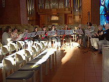
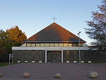
The foundation stone for the new church building was laid on October 16, 1971, the parish center was handed over in June 1972 and the St. Cyriakus Church was consecrated on June 23, 1973. The church, with a high pyramid- shaped roof , was designed for 5,000 people, although the number of congregations has exceeded this number by 1,000 since the 1980s. In 1992 there was an artistic redesign based on designs by Claus Kilian . On June 23, 1998, a new pipe organ was inaugurated for the 25th anniversary of the parish of St. Cyriakus .
Plans to build a second Catholic church on Elbestrasse were not implemented.
Emmaus Church
The Evangelical Lutheran parish of Braunschweig-Weststadt was founded in 1966, it has the Emmaus Church, which was built between 1980 and 1983, and belongs to the Braunschweig Provostry . The house in the middle on Recknitzstraße, inaugurated in 1976, is used today by the mit Uns congregation , an Evangelical Lutheran congregation for mentally handicapped people.
Other denominations
The house of the church on Lichtenberger Straße, which was inaugurated in 1969, was given up by the Evangelical Lutheran Church in 2007 and a Baptist congregation is now using it.
Works of art
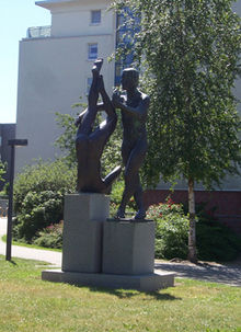
There are some statues in the Weststadt. Particularly noteworthy are the sculptures "Descent from the Cross" and the "Pair of Figures". The "Descent from the Cross" is on the market square in front of the Emmaus Church. It was inaugurated on November 10, 1983 and is a sculpture by the Cologne sculptor Helmut Moos. The sculpture “Pair of Figures” by Andreas Krämmer was inaugurated on December 2nd, 1995. Another number of works of art can be found in the Westpark. The two parishes in Weststadt also have window panes richly decorated with contemporary art and are equipped with other modern objects. The windows of the Cyriakus Church depict various scenes from the Old and New Testaments.
Recreation, leisure and sport
Parks and green areas
The Weststadt is surrounded by park and forest areas. Furthermore, the Fuhse Canal , a small artificial ditch, runs south of the western part of the city , where you can walk and cycle in sections along the bank. The former ring track , which has been converted into a pedestrian and cycle path, runs to the east . Via this one can reach the western ring area, the garden city and the kennel area and the South Pacific. In the Weststadt area, panels on the timeline provide information about the history of the railway and the city's economy.
West Park
The Westpark is a local recreation area that extends over an area of 240 hectares. The park areas within the local recreation area amount to 110.8 hectares, other areas include allotment gardens, agricultural areas and ponds. The Westpark was created from 1980 on the basis of an overall plan by Prof. Nagel and is currently still under development. The south-western part partly takes on the features of a forest and offers protection for different game species. There are also remains of the old Landwehr . The northeast is more rural and is criss-crossed by various wildflower meadows. In the north-western part there are the reef ponds and various other biotopes.
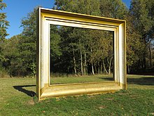
The park is enriched by some works of art, designed and implemented by the HBK Braunschweig , such as “The picture frame” and the sculptures “The chair”, “The couple” and “The information pillar”.
One of the most important projects in recent years was primarily the construction of a three-row avenue of lime trees in an east-west direction with a walking, cycling and riding path along the Madamenweg. From 2006 to 2007, a youth park and playground were built in the south of the Westpark next to the western urban development. This was done as a replacement for the castle park built in 2005 for the ECE Schloss-Arkaden shopping center . A large lake with an island was to be created in the northeast of the West Park.
In the east of the Westpark, the “Millennium” event area was to be built with an event hall, a fitted open-air theater and a viewing mountain made of rubble. The Millennium Hall has been in operation so far. When completed, the mountain will represent the highest point in Braunschweig. It offers a clear view of the entire city of Braunschweig.
Park Muenchenstrasse
Another park is planned under the project name “Parkanlage Münchenstrasse”. The new park in the east of Weststadt is being built between Ludwig-Winter-Straße, Am Queckenberg, Am Lehmanger and the A 391 . The park is to be co-financed with subsidies. The first plans for this park were made in the 1970s. The park is to be designed in a modern style. The fallow land was part of the grounds of the Braunschweig-Broitzem airport and the Münchenstrasse barracks until 1945.
Green corridor west (Donaupark)
A 9-hectare green area close to the citizen is the so-called Donaupark, which is colloquially known after Donaustraße (there is no official name, in municipal documents it is called Grünzug West ). It runs through the southern half of Weststadt for almost 1700 meters and follows the course of a high-voltage line. The Donaupark offers a car-free walking and cycling connection between the west and the east of the southern western city. There are a couple of playgrounds in the park, and Weststadt's water playground is on Muldeweg.
Broitzemer Holz and Timmerlaher Busch
To the west of the district lie the two forests of Broitzemer Holz and Timmerlaher Busch . A wide network of paths offers opportunities for relaxation and walks. There is also game there.
freetime and sports
The Westpark offers numerous opportunities for sporting activities, such as the Raffteich summer pool and the Westpark district sports facility. A disc golf facility with 18 baskets and a cross-generational trim facility (calisthenics) can be used free of charge. You can skate and play basketball on the youth field. There are football fields in several places in Weststadt.
societies
The Weststadt Citizens' Association supports all initiatives and working groups whose work can have a positive effect on the quality of life in the district. He works closely with the organizations that want to ensure more coexistence in the district with their events. Resident sports clubs are the SC Victoria Braunschweig, the Schützenverein Belfort, the KS Polonia Braunschweig, the TC-Westpark and the Koronar-Sportverein Braunschweig. In addition, the MTV Braunschweig has been based in the Westpark district sports facility since it moved out of the kennel area.
Allotment gardens
In the area of Weststadt and Westpark there are the allotment garden associations KGV Einigkeit, KGV Ganderhals, KGV Hermannshöhe, KGV Holzenkamp, KGV Klosterkamp, KGV Kröppelberg, KGV Lange Wanne, KGV Am Lehmanger, KGV Madamenweg, KGV Raffteich, KGV Am Timmerlaher Busch, KGV Weinberg and KGV Südwest.
Culture and events
The Kulturpunkt West (formerly the Weststadt community center ) is located on Ludwig-Winter-Straße and is an event location for cultural and social purposes.
The Braunschweiger Bucherbasar interest group has been organizing the Braunschweiger Bucherbasar at Kulturpunkt since 2002.
On May 18, 2008, the Weststadt Citizens Brunch took place for the first time. This was organized by the Bürgererverein Weststadt eV with the building cooperative reconstruction, the neighborhood association reconstruction and the Nibelungen-Wohnbau-GmbH in the shopping center Elbestraße. Another brunch was held in 2010 and 2012.
Other regular events are the summer festival and the kite festival.
Weststadtfest
Once a year in September, the three-day Weststadt Festival takes place on the fairground on Ludwig-Winter-Straße.
West city week
The Weststadtwoche is an annual themed week with events and discussions on social issues, in which various actors from the Weststadt take part.
Christmas Market
The district's Christmas market takes place every 3rd Advent in the Weststadt shopping center.
politics
| City district Weststadt | |
|---|---|
 Location of the Weststadt district (red) in Braunschweig |
|
| District Mayor: | Ulrich Römer (initially independent, currently [2017] SPD) |
| District: | No. 221 |
| Residents: | 23,443 |
| Surface: | 6.793 km² 3.5% of the city area of Braunschweig |
| Population density: | 3,394 inhabitants per km² |
City District Council
The city district council of Weststadt has 17 members and has been composed as follows since 2016:
From 2011 to 2016, the following parties were represented in the district council of the Weststadt district: the CDU with 7 seats, the SPD with 7 seats, the Left with one seat, the BIBS with 1 seat and the Greens with one seat.
From 2006 to 2011, the following parties were represented in the district council of the Weststadt district: The CDU with 9 seats, the SPD with 6 seats, Die Linke with one seat and the FDP with one seat.
District Mayor
Dirk-Robert Stanko of the CDU was the district mayor of the Weststadt district until his death on December 31, 2007. His successor was Rolf-Dieter Meyer (CDU), who had been a youth and contact officer for many years. Since the 2011 election, the pastor i. R. Ulrich Römer (independent, now SPD) District Mayor.
Statistical districts
The city district is made up of the following statistical districts:
The majority of the Weststadt is distributed over the statistical districts
- Hermannshöhe (No. 26)
- Rothenburg (No. 27)
- Vineyard (No. 28)
The southwestern part is in the statistical district
- Broitzem (No. 56)
coat of arms
In green under a raised silver (white) wavy bar, a silver (white) young, growing, three-leaf tree.
The Weststadt is the youngest part of Braunschweig. With the Westpark and many other green spaces, it is also a district in the country. This identity is symbolized by the young tree growing out of the base of the shield. Most of the streets in Weststadt are named after rivers (currently 75). This peculiarity is symbolized by the wave bar according to the principle pars pro toto (a part [stands] for the whole). These symbols of nature and the green color of hope illustrate the residents' hope for further prosperous growth in the district in a peaceful future. (The coat of arms was unanimously adopted as the district coat of arms by the district council on April 25, 2007 after a previous citizen survey.)
Economy and Infrastructure
Public facilities
There are five old people's and nursing homes in the city district: The old people's home of the Alerds Foundation , the Brockenblick senior citizens' residence, the St. Thomaehof Foundation, Living with Future (assisted living on Ilmenaustraße) and the house on Lehmanger.
There are three banks in the city district: a branch of the Braunschweigische Landessparkasse (Alsterplatz), a branch of Postbank (shopping center Elbestraße) and a branch of Volksbank BraWo (shopping center Isarstraße).
In addition, the Braunschweig office and the Braunschweig branch of the Federal Agency for Technical Relief , Johanniter-Unfall-Hilfe eV , the Lower Saxony State Office for Remuneration and Supply, the State Office for Water and Waste Braunschweig, the Lower Saxony State Office for Water Management, Coastal Protection and Nature Conservation (Formerly Lower Saxony State Office for Water Management and Coastal Protection), the Tax Office for Search and Criminal Matters Braunschweig, the Waterways and Shipping Office Braunschweig and the Office for Agricultural Structure are located in the district.
education
Day care centers:
- AWO day care center Ilmenaustraße
- AWO Children's and Family Center Muldeweg
- DRK family center - Ilmweg crèche
- Ev.-luth. Ahrplatz family center and daycare center
- Ev.-luth. Family center and day care center "Noah's Ark" (Lechstrasse I)
- Ev.-luth. Family center and daycare center "Mittenmank" (Lechstraße II)
- Catholic family center St. Maximilian Kolbe
- Children's group Till Eulenspiegel eV - Lüttenland
- Children's group Till Eulenspiegel eV - Till makes bimbambule
- Municipal day-care center Alsterplatz
- Municipal day care center Recknitzstrasse
- Waldorf kindergarten "Rudolf-Steiner-Straße eV"
Schools:
- Primary school Altmühlstraße (before: Am Lehmanger)
- Primary School Ilmenaustraße
- Rheinring primary school
- Orientation level Rothenburg (until 2004)
- Rothenburg secondary school (until 2009)
- Realschule lifeLearning
- Wilhelm Bracke Comprehensive School , integrated comprehensive school with upper secondary school level
- Free Waldorf School Braunschweig eV
University of Applied Sciences:
- Department of Social Work at Ostfalia University of Applied Sciences (until 2010)
economy
The Weststadt is largely a residential area. There are smaller commercial areas on the edge. The Friedrich-Seele-Straße industrial park is located in the south-east of Weststadt. Resident are u. a. the company Schimmel-Pianos , on the same property is the Schimmel industrial park with numerous other companies, the Telekom , the UHER Informatik Braunschweig, the MIAG Fahrzeugbau GmbH , the Connexus GmbH, the Setron GmbH, the Action Europe GmbH and other small companies. In addition, the Braunschweig branch of BauBeCon is located in the Weststadt.
traffic
The Weststadt has a direct connection to the A 391 (Westtangente): Junction Braunschweig-Weststadt.
The Weststadt was designed as a car-friendly district with mostly a sufficient number of parking spaces. There are road connections to Broitzem, the garden city, Timmerlah, Rüningen and the Braunschweig city center. Elbestraße is to be continued in the future and will lead along the towns of Broitzem, Timmerlah and Stiddien to Salzgitter-Thiede .
In terms of public transport , the Weststadt has two tram routes , which are used by tram lines 3 and 5 of the Braunschweiger Verkehrs-GmbH . The two routes were opened on May 28, 1978. They enable a connection to the city center in just a few minutes. Several bus lines start from the traffic junction Donauknoten (junction Donaustraße / Elbestraße / Münchenstraße) to Broitzem, Rüningen and Vallstedt, among others.
The Weststadt used to have a rail connection with Broitzem station. In the future, another stop (Braunschweig-West) is to be built to connect the Weststadt to the regional rail network. The new stop on the Danube Street / Frederick mind-road should among other P + R and B + R have. Contrary to the original plans, construction work has not yet started. In the meantime (as of December 2012) the Zweckverband Großraum Braunschweig only speaks on its website in the regional train concept 2014+ that the realization of a stop is being examined.
literature
- Edmund Heide and Georg Heide: Braunschweig-Weststadt - A portrait. Braunschweig 2000.
- Edmund Heide: Braunschweig-Weststadt 1960-2010: A district introduces itself. Braunschweig 2010.
Web links
- Homepage of the district on bs-west.de
- District development Weststadt
- Article of the city of Braunschweig
- Website of the City District Council Weststadt on braunschweig.de
Individual evidence
- ↑ a b Braunschweig in the statistics. Population according to city districts. In: Braunschweig.de. City of Braunschweig - Department of Urban Development and Statistics, December 31, 2011, accessed on December 10, 2012 .
- ↑ boundaries of the city districts (valid from 01.11.2011). (PDF; 184.10 kB) City of Braunschweig , November 1, 2011, accessed on August 25, 2014 .
- ^ City of Braunschweig: Urban redevelopment west - northern west city
- ^ Announcement of the naming of neighborhoods. (PDF; 5.6 MB) In: braunschweig.de. City of Braunschweig, accessed on November 21, 2011 (map of the (colored) neighborhoods): "The Administrative Committee of the City of Braunschweig decided in its meeting on June 24, 2010 to designate neighborhoods in the Weststadt district: (I) Isarviertel, (II ) Elbeviertel, (III) Rheinviertel, (IV) Emsviertel, (V) Donauviertel "
- ↑ Braunschweig rent index
- ↑ BBG Journal p. 16 (PDF; 6.4 MB)
- ^ City district council 221 Weststadt
- ^ Bahnhof Weststadt comes in 2010 at the earliest. In: Braunschweiger Zeitung . Retrieved on December 4, 2012 (fee required).
- ↑ Regional train concept 2014+. Zweckverband Greater Braunschweig, accessed on March 1, 2018 .

