Kralenriede
|
Kralenriede
City of Braunschweig
|
|
|---|---|
| Coordinates: 52 ° 18 ′ 18 ″ N , 10 ° 32 ′ 32 ″ E | |
| Height : | 75 m |
| Residents : | 6245 (December 31, 2015) |
| Incorporation : | 1934 |
| Postal code : | 38108 |
| Area code : | 0531 |
|
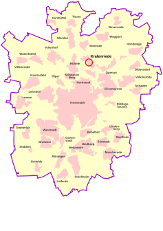
Location Kralenriedes in the Braunschweig city area
|
|
|
Monument Steinriedendamm 15 in the industrial area Steinriedendamm
|
|
Kralenriede is a district in the north of Braunschweig with about 6000 inhabitants, which belongs to the city district 332 ( Schunteraue ). The district is named after the stream of the same name, which flowed from today's sandy desert path to the northwest to the Schunter.
location
The district is located on a geest typical of the plain north of Braunschweig , which was previously completely forested and is surrounded by the Schunter in the south, west and north-west. In about 75 m above sea level. NHN , in the middle of the height marked Rühmerberge , the eponymous Kralenriede rises and flowed in a straight line to the northwest. The course is still present in the Schunteraue below the sports field. In the southeast, the area is bounded by the Kehrbeeke flowing from the Querumer Forest, which flows into the Schunter at the level of the student dormitory.
In the south, Kralenriede borders on the Schuntersiedlung , in the west - separated by the Schunteraue - on Rühme and the Vorwerkiedlung , in the north on Bienrode and in the east on Querum and the Querumer Forest.
history
The area's earliest development took place in 1915, when the Bienrode ammunition factory set up an ammunition depot and a facility for the manufacture of powder. By 1923 54 houses had been built for workers. In 1923 the Reichswehr Ministry laid out a parade ground in the area of today's Schreberweg, which is now covered by allotment gardens and single-family houses. To the north of it, after the razing of Braunschweig Castle, a mountain was heaped up from the ruins of the castle, of which a memorial stone reminds us. The mountain was initially popular as a toboggan hill, but has now become overgrown with trees due to lack of care and was partially removed in 2005 in the course of the reconstruction of the castle facade in search of original fragments. This area of the former parade ground up to the motorway is also known as the "sand desert".
Location structure and traffic
The district includes the Bastholz industrial park in the northeast and the Steinriedendamm industrial park in the southwest. The latter has a connection to the Braunschweig – Wieren railway line to the east of the district . In between there are apartment blocks, single-family houses and row houses. The A2 motorway delimits the town from Braunschweig-Wolfsburg Airport in the north . Kralenriede can be reached by the Metrobus line M 16/416 (Kralenriede – Innenstadt – Völkenrode), the bus line 426 (Flughafen-Bienroder Weg-Rebenring-Hamburger Straße) and the bus line 436 (Airport – Bastholz – Östlicher Ring – Hauptbahnhof, only Monday to Friday) tied up.
The Fraunhofer Institute for Surface Engineering and Thin Films and the Wilhelm Klauditz Institute for Wood Research are located in the southeast . There is also a primary school, a kindergarten, the student dormitory "An der Schunter", the Sandwüsten shooting club from 1959 and the Kralenriede sports club from 1922.
coat of arms
Kralenriede does not have its own local coat of arms, but is represented in the coat of arms of the city district of Schunteraue. It combines the five settlements of Schuntersiedlung , Kralenriede, Bastholzsiedlung, Sandwüsten and Michelfelder-Siedlung.
The coat of arms therefore shows five blue wavy bars on a golden background on one half, which symbolizes the settlements in the Schunter area. The second half shows a golden oak leaf on a blue background. This stands for the meadow landscape. The coat of arms was designed by Peter Ohst and published for the first time in the chronicle of the 50th anniversary of the Schuntersiedlung.
Origin of name
The eponymous Kralenriede contains the ending -riede , which means something like "trickle, small stream" and occurs very frequently in the Querumer Forest as well as up to Gifhorn. The historical evidence of the name from 1730 is Crahl Rye or Krahl Rie . Blume does not rule out that Krahl could come from a family name, possibly that of the landowner, but favors the compound krâlen , which is recorded in the Grimm dictionary for “loud sound, noisy”. Accordingly, Kralenriede means "rushing brook". The transfer of the stream name to the surrounding forest area can also be observed in the Querumer Forest with the names Steinriede and Tannenriede as well as elsewhere in the Eilenriede .
Web links
Individual evidence
- ↑ a b Population statistics on braunschweig.de
- ^ Prussian land survey 1901: Topographic map 1: 25,000, sheet 1959 Meine , edition 1937, site of the German Historical City Atlas.
- ^ City portrait of Kralenriede. In: Homepage of the city of Braunschweig. Retrieved September 22, 2012 .
- ^ City portrait Kralenriede: The sand desert. In: Homepage of the city of Braunschweig. Retrieved September 22, 2012 .
- ^ Arnold Rabbow: New Braunschweigisches Wappenbuch. Braunschweiger Zeitungsverlag, Meyer Verlag, Braunschweig 2003, ISBN 3-926701-59-5 , p. 27.
- ↑ Herbert Blume : Oker, Schunter, Wabe , in: Braunschweigisches Jahrbuch für Landesgeschichte, vol. 86, Braunschweig 2005, p. 32 ff.


