
Eilenriede
The Eilenriede is of around 640 ha large city forest of Hanover . It is located east of the city center and is divided into a northern part in the Zoo district and a southern part, which essentially belongs to the Kleefeld district.


history
Emergence
It is believed that the Eilenriede was once the western part of the northern forest . This large contiguous forest area covered large parts of what is now Lower Saxony between Braunschweig and Hanover until the late Middle Ages. The first part of the name Eilenriede (Eilen) is derived from the alder (Ellern) that used to be mainly found there . The second part of the name (Riede) (see also: Ried ) is an old name for swampy soil. An earlier name was Eyllerie , as in a plan of the city of Hanover penned by Ernst Eberhard Braun from 1762.
From 1241 the city of Hanover received a right to joint use of the Eilenriede forests. In 1371 it was given to the citizens of Hanover by the Dukes Wenceslaus and Albrecht of Saxony as a thank you for their support in the War of the Lüneburg Succession . This gave the citizens the right to use and maintain the forest area as their property. At the same time there was an obligation to expand the forest area. Building on the predominantly marshy area was hardly possible, so that the character of the forest has been preserved for centuries. By 1920 the forest was expanded by around 210 hectares.
The Eilenriede was a looted forest in the 17th century due to the cattle fattening and the lumbering. Economic rules were introduced in 1729 to improve forest development. The planting of fast-growing conifers alleviated the wood shortage. The introduction of coal as fuel was beneficial for the forest in the 19th century. During the Second World War , the forest was damaged by bombs, about a third of the area was destroyed.
The construction of the Messeschnellweg, for which preparations had already begun in 1949, led to a significant break in the 1950s.


Landwehr
In the middle of the 14th century, against the background of the War of the Lüneburg Succession (1370-1388), a Landwehr was built around the city to protect Hanover , especially in the Eilenriede. The Landwehr was an advanced border security and fortification system with waiting towers at the road passages. Inside or on the edge of the Eilenriede are the remains of the following former waiting towers and waiting houses:
|
|
Later the watchtowers of the Landwehr became foresters to curb wood theft in the Eilenriede. Well-preserved wall and ditch sections of the Landwehr can be found today in the city forest for several kilometers in the area of the horse tower, the Döhrener tower and the island ditch behind the zoo.

Ship ditch
The ship moat is a historical relic in the Eilenriede . This was a canal built in the Middle Ages that connected the Aegidientor in the city with the Altwarmbüchener Moor . It was used to transport peat and wood to the city, where it was needed as fuel or building material. The trench was nine kilometers long. From tax thief he was part of the Hanoverian Landwehr .
The Schiffgraben has only been preserved over a length of three kilometers in the Eilenriede between the music college and the forest restaurant Steuerdieb .
Lawn maze

The wheel is in the northern Eilenriede . It is a lawn maze with circles of lawn and pebble stone surfaces around a central linden tree . The labyrinth was first mentioned in 1642 in the city chronicle of Hanover. At that time it was located at today's Emmichplatz and in 1932 it was moved to its current location in the forest.
Such facilities were places of worship in old Germanic times. Through ritual dances in the labyrinthine lines, the people wanted to reconcile with the surrounding forces of nature. The facility in Eilenriede is one of the last four historical lawn labyrinths in Germany. The other three are the Wunderkreis in Kaufbeuren , the Schwedenhieb in Graitschen and the Schwedenring in Steigra .
Park remodeling

Around 1900, the Vordere Eilenriede near the city was converted into a forest park by city gardening director Julius Trip . There were clearings and watercourses as well as small bodies of water, to which the large pond belongs. In addition, sculptures and sculptures were placed in prominent places . The sun playground and the play park WAKITU (forest children's play area) were the city's first public playgrounds in 1895. A second phase of redesign followed between 1928 and 1932 under Horticultural Director Hermann Kube : paths were widened and separate routes were created for pedestrians, cyclists and riders. The two playgrounds were expanded and modernized, a lawn and a toboggan run were newly created, the “bike” was relocated to the north-eastern Eilenriede and other sculptures - financed by the Fritz Behrens Foundation - were erected.
Eilenriederennen

The northern Eilenriede was a racing track for motorcycle races between 1924 and 1939 and 1949 and 1955 . The Eilenriede race was a major local event. In a few years it developed into a motorsport institution with an international reputation. The five-kilometer circuit led in a triangular shape through the middle of the forest. The start and finish point was the forest restaurant Steuerdieb . The other two cornerstones were the Lister Tower and the Hanover Zoo . The first official race started on March 30, 1924 with 168 motorcycles. The first death occurred in 1928. The race was suspended during the Second World War . The number of spectators increased from 40,000 at the beginning to 130,000 in 1951. After that, the audience enthusiasm declined. In 1955, environmental reasons and increased safety requirements brought the racing events to an end.
Location and botany
The Eilenriede has a north-south extension of about six kilometers. It extends with its southwestern foothills to the Maschsee . The Messeschnellweg was built in 1958 in a north-south direction through the Eilenriede. A noise protection wall was built later . The entry and exit roads Am Pferdeturm and Bemeroder Strasse, Bernadotte-Allee and the connection between Fritz-Behrens-Allee and Steuerdieb, which is closed on weekends, lead through the Eilenriede or along it.
The Eilenriede is divided into two parts:
- The northern Eilenriede stretches from Walderseestrasse in the north to the horse tower in the south; it is part of the Zoo district .
- The southern Eilenriede begins south of the horse tower and extends to the Döhrener tower . It mainly belongs to the Kleefeld district . The area south of Bemeroder Straße near Bischofshol to the railway line belongs to the Waldheim district , the further section to Hildesheimer Straße belongs to Waldhausen . The adjoining area south of the Engesohde town cemetery to the Maschsee belongs to the Südstadt .
Today there are 75% deciduous trees in the Eilenriede. In addition to mainly oak , red beech , alder and birch, there are also numerous other tree species. The coniferous trees on the sandy soils are mainly pine and larch . In the past, mainly alders (Ellern) grew on the damp and swampy terrain . In March and April the forest floor is covered extensively with carpets of plants. Then larkspur , celandine , the yellow anemone and the white wonder leek bloom .
The groundwater level of the Eilenriede has fallen over the past few years due to the progressive development and sealing of the city. In April 2008, measures were taken to raise the groundwater level of the forest area in order to preserve the original vegetation.

Carpet of flowers on the forest floor in April

Heiliger's well , containing sulfur

Historic bathing area Teufelsbad (also Kopperloch ) near Heiligers Brunnen

Large areas of water standing in the forest in spring in the southern Eilenriede

A typical picture in summer: a dry watercourse


leisure
There are numerous leisure facilities in the Eilenriede. Hannover Zoo is located on the edge of the northern Eilenriede . The former bird protection tree on the eastern edge was enlarged and developed into a forest station in 2004. In 2009, this was supplemented by a 36 meter high forest adventure tower, which allows views of the Eilenriede forest and from the top platform also of the treetops.
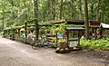
80 km of hiking trails, 38 km of bike paths and 11 km of bridle paths lead through the forest. The first cycle path was built in 1900 between the zoo and the horse tower . The skating is on a route from Lister Turm released until Steuerndieb. There is also a fitness trail, a mini golf course , four toboggan mountains, a high ropes course in Wakitu, ten playgrounds, twelve lawns for sunbathing as well as restaurants, kiosks and forest cafés.

Sunbathing area

Entrance to the WAKITU play park

Kiosk in the forest
Milk house

Forest station

First cycle path from 1900 with a memorial stone


Monuments and sculptures

In the northern Eilenriede, mostly on the edge of the forest, several monuments were erected.
On a circular lawn at the intersection of Yorckstrasse and Hohenzollernstrasse on the forest side stands the group of princesses , an enlarged copy of a statue, the original of which was created in the first half of the 19th century by the Berlin sculptor Johann Gottfried Schadow and can be seen in the Alte Nationalgalerie . It turns Princess Louise (later wife of Prussian King Friedrich Wilhelm III. ) And their younger sister Friederike (afterwards wife of King Ernst August of Hanover). This monument is the last German emperor on a foundation of Wilhelm II. And became of the created by the Venetian sculptor Valentin Casal. The "Crown Prince of the German Empire and of Prussia" Wilhelm unveiled the monument on July 19, 1910 as the official representative of his father.
In this area on Walderseestrasse there is also the Waldersee Memorial to the Prussian Field Marshal Alfred Graf von Waldersee , who spent the last years of his life in a villa on the edge of the Eilenriede.
On Walderseestrasse opposite Fritz Beindorff-Allee, the pelican fountain with two bronze pelicans reminds of Fritz Beindorff as a Hanoverian senator and former owner of the office supplies company Pelikan AG .
The sculptor Carl Dopmeyer created the Burckhardt memorial with a bronze portrait relief, which was erected in 1883 in the front Eilenriede. It commemorates the Hanoverian forester and later forest director Heinrich Christian Burckhardt , who was responsible for the forest administration of the province of Hanover in 1866 after the annexation of the Kingdom of Hanover by Prussia .

Waldersee memorial by Bernhard Hoetger , 1915

Pelican fountain by Ludwig Vierthaler, 1961

Burckhardt memorial by Carl Dopmeyer , 1889

Fabulous animal by Ludwig Vierthaler , 1931

Steinbock by Ernst Gorsemann , 1929

Cenotaph of the Hanoverian royal ulans by Ernst Gorsemann, 1922

Wisent by August Waterbeck , 1935

Hirsch by August Waterbeck, 1936

War memorial for the 73rd Infantry Regiment, 1928

Memorial stone on the Fischer oak for court conductor Carl Ludwig Fischer

"Alemannenstein" - memorial stone for the Corps Alemannia [10]


Others

The robber Jaspar Hanebuth was born in 1607 in what is now the Groß-Buchholz district and drove his mischief in the Eilenriede. In the turmoil of time, such as the plague, wars and occupations, he robbed and murdered over a long period of time. He is said to have ambushed his victims at the edge of the forest near today's zoo. After his arrest in 1652, he confessed to 19 murders and was publicly beaten for it . A road on the edge of the forest was named after him as the Hanebuthwinkel.
To safeguard the interests of Eilenriede and some neighboring forests of the Council of the City of Hanover based on years of civil protests in 1956 created the Eilenriede Advisory Board . The reason for the creation of this body was the construction of the Messeschnellweg . Not only the fragmentation effect of this expressway, but also the associated traffic noise caused resentment among the population. Even today, annual logging takes place in the Eilenriede, which occasionally leads to criticism.
Some facilities near the Eilenriede are named after her:
- Eilenriedehalle , an event hall belonging to the Hanover Congress Centrum for around 7,000 people
- Eilenriedestadion , home of the youth and amateur teams of Hannover 96
- Eilenriedestift, a retirement home
Shortly after the end of the Second World War, an auxiliary bicycle motor was built under the manufacturer and model name Eilenriede ; it sat at the front fork, had a friction roller drive and was one of the few such engines that worked on the four-stroke principle.
literature
- Franz Hallbaum: The front Eilenriede in Hanover. Forest park and beauty forest . In: The garden art. Vol. 44 (1931), pp. 159-164. Digitized version (PDF; 1.5 MB)
- Gerhard Richter: Origin and development of the public green in Hanover up to the incorporation of Linden in 1920 . Hanover 1969 (dissertation at the TU Hanover).
- Herbert Röhrig : Let the citizens their Eilenriede , from: Journal Lower Saxony , 1971, Issue 3, published by the Lower Saxony Heimatbund e. V., Hanover, 1971
- Speier, Martin; Pott, Richard: The Hanover city forest "Eilenriede" from a geobotanical and historical perspective . In: One hundred years of Reinhold Tüxen. Geobotany and vegetation geography . Ed .: Richard Pott. Hannover 1999, pp. 279-303.
- Bettina Borgemeister: The city and its forest. An investigation into the forest history of the cities of Göttingen and Hanover from the 13th to the 18th century . Hannover, Hahn 2005. (Publications of the Historical Commission for Lower Saxony and Bremen. 228) ISBN 3-7752-6028-5 .
- Joachim Lehrmann : Gangs of robbers between Harz and Weser . Lehrte, Lehrmann-Verlag 2004. ISBN 3-9803642-4-0 . (in it in detail Hanover's robbery killer Hanebuth)
- Ellen Schneider: The forest park. Ideas and manifestations in Germany between 1880 and 1935 . Remagen-Oberwinter: Kessel 2011. Dissertation TU Dresden, 2010. Therein: p. 49–77: Selected examples of realized forest park projects (p. 52–62: The Vordere Eilenriede Hannover: design under Julius Trip and Hermann Kube ) ISBN 978-3 -941300-52-1
- Silke Beck, Klaus Helmer (Red.): City forests in Hanover. Die Eilenriede , with texts by Gerhard Dirscherl, Gerd Garnatz, Gudrun Seth and Carl Ferdinand Ernst, Hanover, September 2012, pp. 30/31; [1] (PDF; 1.9 MB)
- Silke Beck (Red.): Eilenriedekarte (PDF; 724 kB) , with texts by Carl-Ferdinand Ernst and Gerd Garnatz, Hanover, September 2012
- Helmut Knocke , Hugo Thielen : Eilenriede. In: Hannover Art and Culture Lexicon , p. 101ff.
- Eva Benz-Rababah : Eilenriede. In: Klaus Mlynek, Waldemar R. Röhrbein (eds.) U. a .: City Lexicon Hanover . From the beginning to the present. Schlütersche, Hannover 2009, ISBN 978-3-89993-662-9 , p. 149.
Web links
- Information about the Eilenriede at www.hannover.de
- Further information, descriptions, pictures and maps to the Eilenriede
- Hermann Löns: Seven school essays by Aadje Ziesenis in the Gutenberg-DE project
- Program of measures for the development of landscape areas; State capital Hanover; (PDF; 3.3 MB)
Individual evidence
- ↑ a b c d The Eilenriede. One of the most important urban forests in Europe in the heart of Hanover has a lot to offer. In: hannover.de . State capital Hanover , accessed on January 17, 2018 .
- ↑ Ernst Eberhard Braun: Situation of the city of Hanover in specie whose boundaries and pasture so the Alt-Städer citizenship in which surrounding offices, partly private, partly jointly responsible , in the holdings of the Gottfried Wilhelm Leibniz Library - Lower Saxony State Library , 1762
- ↑ a b The miracle of Hanover , Der Spiegel 23/1959 of June 3, 1959, p. 56 f.
- ↑ Geographical coordinates of the lawn maze: + 52 ° 23 '18.24 ", + 9 ° 45' 55.15" ( GPS coordinates, for Google Maps: LL 52.388400, 9.765320 )
- ↑ Ellen Schneider: The forest park. Ideas and manifestations in Germany between 1880 and 1935. Remagen-Oberwinter: Kessel 2011, pp. 52–62.
- ↑ Route map ( Memento from July 17, 2007 in the Internet Archive )
- ↑ Article about the history of the race in the Hannoversche Allgemeine Zeitung
- ↑ Forest adventure tower on the grounds of the forest station Eilenriede on zimmerei-brand.de
- ↑ Description on Hannover.de , accessed on September 8, 2017
- ↑ Ernst Bohlius, Wolfgang Leonhardt: "Die List": 700 years of reviewing the village and town history , Books on Demand, Norderstedt, 2003, p. 30
- ↑ Joachim Wolschke-Bulmahn & Hansjörg Küster: The Eilenriede. (PDF, 1.44 MB) Hanover's city forest and the Eilenried Advisory Board. State capital Hanover , May 2016, accessed on April 17, 2017 .
- ^ Mathias Klein: Eilenriedebeirat criticizes the city. Logging debate. In: Hannoversche Allgemeine Zeitung . February 18, 2014, accessed March 4, 2016 .
- ^ NSU bicycle "Eilenriede" with auxiliary engine from 1952
Coordinates: 52 ° 23 ′ 16 ″ N , 9 ° 46 ′ 10 ″ E