Hildesheimer Strasse (Hanover)

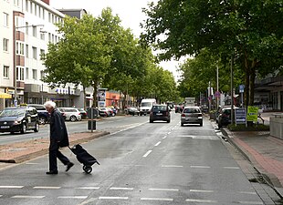
The Hildesheimerstraße is a four-lane residential and commercial street in Hanover and south adjacent city Laatzen . Of the approximately 14 kilometers total length, about six kilometers are in the urban area of Hanover and eight kilometers in that of Laatzen. The street is one of the longest in the state capital. It is named after the city of Hildesheim .
course
Hildesheimer Straße runs from Hanover city center in a relatively straight line in an approximately south-south-east direction. It begins at Aegidientorplatz and, as an arterial road, crosses the Hanoverian districts of Südstadt , Waldhausen , Döhren and Wülfel . Important residents of the street are the Hanover City Library , the House of the Region of the Hanover Region and the Gilde Brewery . The Engesohde city cemetery is adjacent to the street. The Hildesheimer Straße in Waldhausen is bridged by the Hanover – Altenbeken railway line and the Südschnellweg .
Shortly after the street Am Brabrinke , Hildesheimer Straße crosses the city limits to Laatzen, where the house numbers start all over again. The street crosses the Laatzen districts of Alt-Laatzen , Grasdorf , Rethen and Gleidingen . Notable residents are here, the municipal swimming pool aquaLaatzium and the Klinikum Agnes Karll the hospital Hanover region . Behind the city limits of Laatzen, it becomes Heiseder Straße in the Sarstedt district of Heisede . The Hannöversche Südbahn runs over them in Grasdorf .
Both in Hanover and in Laatzen, the development on Hildesheimer Straße is characterized by mixed residential and commercial buildings. The street serves as a local supply for the residents of the surrounding districts .
history


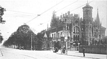
Postcard number 389 from Georg Kugelmann , dated 1906
The Döhrener Tower was built in 1382 . It was located on the trade route to Hildesheim, which was not yet specified . In 1750, Hildesheimer Strasse was referred to on old maps as the road to Hildesheim, Braunschweig and Goslar . In 1845 it got its current name in the city of Hanover. In 1960 it was still called "Hildesheimer Chaussee" in the community of Grasdorf. The planned expansion began in the 1860s. This gave a continuous route from Herrenhausen to Döhren . There are development plans created so that a systematic public and private buildings could begin. The numbering initially only went as far as Altenbekener Damm .
Hildesheimer Straße was laid out in 1810 at the height of today's Döhren district .
Until 1864, Hildesheimer Straße ran along Höltystraße , from which the former Catholic St. John's cemetery extended to Maschstraße .
In 1872 a horse-drawn tram line was built from the Steintor to the Döhrener Tower and in 1890 it was extended to Laatzen. It was the longest and at the same time one of the first routes on the Hanover tram . From 1893 the tram was electrified and extended to Hildesheim in 1898.
With the introduction of the Reichsstrasse system , the connection between Hildesheim and Hanover became part of Reichsstrasse 6 ( Cuxhaven - Dresden - Breslau ). The later federal highway 6 was moved in the second half of the 20th century, like all federal highways in the city, to the Messe , Süd- and Westschnellweg .
Architectural drafts of the Hildesheim Strip
In Business Promotion Center of Hannover Region an exhibition was organized with the draft from 16 to 25 April 2014 Architecture -Students of the Leibniz University of Hanover for a redesign of Hildesheim Street: The aim of the "Hildesheim Strips" were new ideas and visions for the " City entrance Hanover ”.
Light rail
At the end of the 1970s, the tram was converted into a light rail , with a subway tunnel being built in the southern part of the city. The tunnel runs from Aegidientorplatz to Hilde-Schneider-Allee. The Schlägerstraße , Geibelstraße and Altenbekener Damm underground stations are on this section . There is a single-track sweeping system between the Schlägerstraße and Geibelstraße stations . Here light rail from the city center z. B. in case of failure. From the ramp on Hilde-Schneider-Allee to the Döhrener Tower , the route has an independent track , after which it runs on a special track , each in the middle of the street.
Lines 1, 2 and 8 run under and on Hildesheimer Strasse, as well as reinforcement line 18 at trade fairs with a large number of visitors. Line 1 follows Hildesheimer Strasse almost the entire length to Sarstedt, while line 2 leads to Laatzen and Rethen . Line 8 leaves Hildesheimer Straße in Hanover and turns towards Messe .
literature
- Helmut Jacob: The southern city in Hanover. A contribution to the history and development of a neighborhood from the perspective of Südstädters . Self published in 1993.
- Klaus Mlynek, Waldemar R. Röhrbein (ed.): Hanover Chronicle. From the beginning to the present . Hanover: Schlütersche 1991.
- Klaus Mlynek, Waldemar R. Röhrbein (ed.): History of the city of Hanover . 2 vol., Hanover: Schlütersche 1992 (vol. 1), 1994 (vol. 2).
Web links
Individual evidence
- ↑ Source: Google Maps
- ^ Address book for Hanover from 1960, Grastorf municipality, p. 282
- ↑ Wolfgang Neß : The old village , in: Monument topography Federal Republic of Germany , architectural monuments in Lower Saxony, City of Hanover, part 2, vol. 10.2 , ed. by Hans-Herbert Möller , Lower Saxony State Administration Office - publications by the Institute for Monument Preservation , Friedr. Vieweg & Sohn, Braunschweig / Wiesbaden 1985, ISBN 3-528-06208-8 , pp. 97f.
- ^ Bernhard Dörries, Helmut Plath : Hildesheimer Strasse , in: Alt-Hannover 1600 - 1900 / The history of a city in contemporary images from 1600 - 1900 , ed. on behalf of the city of Hanover and annual gift 1951 from the Kunstverein Hanover, Munich: F. Bruckmann, p. 85, 132
- ^ Arnold Nöldeke : St.-Johannis-Friedhof , in: Die Kunstdenkmäler der Provinz Hannover Vol. 1, H. 2, Teil 1: Monuments of the "old" Stadtgebiet Hannover , Hannover, self-published by the provincial administration, Schulzes Buchhandlung, 1932, p. 257; (Reprinted by Wenner Verlag, Osnabrück 1979, ISBN 3-87898-151-1 )
Coordinates: 52 ° 20 ′ 38.2 " N , 9 ° 45 ′ 48.5" E
