
Hanover light rail

| Basic data | |
| Country | Germany |
|---|---|
| city | Hanover , Isernhagen, Langenhagen, Laatzen, Garbsen, Ronnenberg, Sarstedt |
| Transport network | Greater Hanover traffic |
| opening | 1975 |
| Lines | 12 (+ 2 supply lines) |
| Route length | 123 km |
| Stations | 197 |
| Tunnel stations | 19th |
| use | |
| Shortest cycle | 10 min per line
(7.5 min on line 10) |
| Passengers | 176 million per year (2016) |
| vehicles | TW 6000 , TW 2000 , TW 3000 |
| operator | üstra |
| Gauge | Standard gauge |
| Power system | 600 V = ( overhead line ) |
The Hanover Stadtbahn is a transport system of public transport in the Lower Saxon state capital Hanover . It was created by converting the Hanoverian tram into a light rail system that combines elements of the tram and the underground . The operator of the light rail is the transport company üstra , the infrastructure facilities belong to the infra .
The light rail is the most important mode of transport in the Hanover region . In 2016, around 176 million passengers were carried with it. At the main train station and seven other stations, there are transfer options to the Hanover S-Bahn , which opens up the closer and wider area (see local transport in Hanover ).

history
The Hanover Stadtbahn was created from the Hanover tram network.
tram

In 1872 the first horse-drawn tram ran in Hanover . Two companies expanded the network in the following years. In 1892 they merged to form the Tram Hannover AG . Between 1893 and 1903 the network was electrified and expanded far into the surrounding area. In 1901, the route network had reached a length of 163 kilometers. The routes led u. a. to Sarstedt , Hildesheim , Barsinghausen , Gehrden , Großburgwedel , Pattensen and Sehnde .
Since the tram produced its own electricity and municipalities in the district Hannover delivered, the company changed its name in 1921 as Ü berlandwerke and road ßenbahnen Hannover AG. The acronym of this name is still part of the current company üstra Hannoversche Verkehrsbetriebe AG .

Of the overland routes, the route to Sarstedt remained after it was closed in the 1950s and 1960s. As a result, the network shrank considerably. From 1951, the fleet was renewed with four-axle Düwag open -plan cars and six-axle Düwag articulated cars . The vehicles were converted to one-man operation from the mid-1960s.
As a result of the protests against fare increases (see red dot campaign ), üstra , which had previously belonged to PreussenElektra, was communalized in 1969 and the Greater Hanover Association, a forerunner of the Hanover region , was founded.
In the course of the advancing light rail construction, most of the above-ground routes in the city center and their connecting connections were shut down from the mid-1970s. The last tram line 16 ( Klagesmarkt - Hauptbahnhof - Königstraße - Zoo - Kleefeld / Nackenberg) operated with Düwag articulated trams ran until September 1996. Its end meant the end of the route in Goseriede to Klagesmarktschleife. Here the tracks lay in sections for several years, in the Klagesmarktkreisel until after 2000.
On the zoo route (Thielenplatz - Emmichplatz - Zoo) there was occasional traffic with historical trams for a while. After the last run on July 12, 1998, the line was closed. In the same year, the switches were removed at Thielenplatz. In 1999/2000 the line to Emmichplatz was cut off when the zoo terminus was rebuilt. The tracks in Königstrasse were removed after they were rebuilt, and in Hindenburgstrasse they disappeared from 2012.
Light rail
Since the 1950s, there have been considerations to run the trams underground in the city center in order to increase their efficiency and make them independent of the increasing vehicle traffic. The first plans envisaged a ring under Georg-, Bahnhof- and Kurt-Schumacher-Straße, which should only be used in one direction. Alternatively, a variant without a ring but with branches at the same height was also considered. However, model calculations showed that the capacity of such structures would not have been sufficient.
At the end of the 1950s, a network was proposed that contained three tunnels with the four crossover points Steintor, Hauptbahnhof, Aegidientorplatz and Markthalle.
In 1962, the Berlin traffic planner Bruno Wehner was commissioned to plan a subway network. This plan was available in 1964, network plan 64 . He envisaged three routes crossing each other at the Kröpcke: A and B routes essentially corresponded to the routes later realized. The C-route should branch out at the Steintor into a branch to the north of the city and further to Garbsen and a branch to Linden-Nord and further to Harenberg. The planned new district on Kronsberg should be developed via the B route.
On June 23, 1965, the city council decided to build a subway according to this plan, which heralded the end of traditional tram operations in Hanover. The tunnel dimensions were based on the specifications of the Federal Ministry of Transport. The tunnels then had to be designed for 2.9 m wide and 103 m long underground trains. Initially, only tunnels were to be built in the inner city area and connected to the existing tram routes. Later, all above-ground routes were to be converted into independent railway bodies without crossing .
Construction began on November 16, 1965 at Waterlooplatz . A short time later, the work was suspended for about a year due to financing problems. After the federal government had co-financed projects to improve traffic conditions in the communities since 1967, work was resumed. Most of the tunnel work was carried out using the cut-and-cover method.
The network 64 shown in particular by the southern B-line and the C line between Kroepcke stone gate and inefficiencies. Therefore, a revised network plan 66 was drafted , which provided for four underground lines in the final expansion:
- Line A: Buchholz - List - city center - Ricklingen - Wettbergen, with a branch at Waterlooplatz to Badenstedt
- Line B: Sarstedt - Laatzen - Döhren - city center - Vahrenwald - Langenhagen, with a branch to Vahrenheide - Sahlkamp - Bothfeld
- Line C: Misburg - Roderbruch - Kleefeld - city center - Nordstadt - Stöcken - Garbsen
- Line D: Kronsberg - Bemerode - Waldheim - Südstadt - City Center - Linden - Limmer - Harenberg

The subway construction authority, which was specially set up in the building department of the state capital Hanover, was responsible for the planning, design and construction of all tunnel works including the technical equipment from 1967 until the completion of the tunnel section C-North (1993) under the direction of Klaus Scheelhaase .
In 1972, the first test drives could take place in the A tunnel between Gustav-Bratke-Allee and Karmarschstraße.
In view of the considerable costs and the duration of the construction work, the implementation of a pure subway concept was abandoned and the current urban railway system developed with tunnels in the city center and largely special railway bodies on the connecting lines above ground.
The first new line after the subway construction decision of 1965 was opened in 1973 and served with tram line 1, on which the first line operations with light rail vehicles TW 6000 were made in March 1975.
On September 28, 1975, with the opening of the first tunnel section from the main train station via Kröpcke, Markthalle and Waterloo to the ramp in Gustav-Bratke-Allee, light rail operations began. The first light rail line, line 12, ran with light rail cars TW 6000 in double traction between the main station and Oberricklingen.
The inner-city tunnel network with the A, B and C tunnels was built without further interruptions until 1993. The above-ground access routes were gradually adapted to the requirements of light rail operations by increasing the distance between the tracks and lengthening the existing flat platforms. There was a long struggle to build the D-tunnel, after all the inner-city D-route was upgraded above ground from 2015 to 2018.
A sharp demarcation between tram and light rail operations, which would be defined by a specific difference, is not always recognizable. There were tram lines that used tramcars to drive light rail lines, and tram lines that served light rail vehicles to serve light rail lines with elevated platforms. When there was a new light rail line from 1993, which regularly ran with single light rail vehicles, while double light rail lines were used on a tram line, the distinction between tram and light rail was abandoned. Henceforth the last line 16 operated with conventional Düwag one-way tram cars was called the Stadtbahn.
| date | lines and underground stations in operation | route | Remarks |
|---|---|---|---|
| September 26, 1975 | Oberricklingen - Waterloo |
A-south | first Hanover tunnel route |
| April 4th 1976 | [Central Station A] - Lahe |
A north | |
| June 18, 1976 | [Laatzen / South (today Laatzen)] - Laatzen / Rethener Winkel - [Rethen / North] | B-south | Tram advance service |
| September 25, 1977 | [Am Sauerwinkel] - Mühlenberg |
A-south | previous endpoint Oberricklingen canceled |
| October 1, 1978 | [Nackenberg] - Medical University / South | C-East | Tram advance service |
| May 27, 1979 | [Black Bear] - Empelde | A-west | Start of light rail operations via the A tunnel on the existing route |
| May 27, 1979 | Kröpcke B - Langenhagen / Berliner Platz |
B-north | |
| May 31, 1981 | [Kröpcke B] |
B-south | |
| 2nd September 1982 | new depot in Döhren | B-south | replaces the old Döhren depot |
| September 26, 1982 | [Schlägerstrasse] - Exhibition grounds (today Messe / Nord) |
B-south | |
| September 26, 1982 | [Aegidientorplatz] |
C-East | Except for the track towards Marienstrasse, all tracks are now in operation |
| March 30, 1984 | [Kröpcke C] |
C-West | |
| September 29, 1984 | [Misburger Strasse] - Roderbruch | C-East | Previous endpoint Medical University / South canceled, tram lead-in operation with TW 6000 |
| June 2nd 1985 | [Steintor] |
C-West | |
| September 24, 1989 | [Aegidientorplatz] - Kleefeld - Roderbruch |
C-East | Now all four tracks of the Aegidientorplatz station are in operation. Connection to the Freundallee sweeping system until 1995 was only an operating line |
| September 29, 1991 | [Langenhagen / Berliner Platz] - Langenhagen | B-north | last line opening with underground platforms |
| September 26, 1993 | [Stone Gate] - Halthoffstrasse |
C-north | |
| September 26, 1993 | [Braunschweiger Platz] - Zoo | C-East | Start of light rail operations via the C tunnel on the existing route |
| May 29, 1994 | Rathaus / Friedrichstrasse - Aegidientorplatz - Central Station - Steintor - Linden-Nord - Limmer - Ahlem | D-West | Start of light rail operations mostly on the existing route |
| September 24, 1995 | [Hogrefestraße (today Freudenthalstraße)] - Marienwerder / Science Park (today Marienwerder Science Park) | C-West | |
| September 24, 1995 | [Braunschweiger Platz] - Freundallee | C-East | Start of light rail operations via the C tunnel on the existing route |
| September 29, 1996 | [Marienwerder / Science Park (today Marienwerder Science Park)] - Garbsen |
C-West | |
| September 26, 1998 | [Stadtfriedhof Stöcken] - Depot Fuhsestrasse (Leinhausen) | C-West | only operating route |
| 5th December 1998 | [Freundallee] - Bult / Children's Hospital (today Children's Hospital on the Bult) | D-South | |
| May 29, 1999 | [Waterloo] |
A-south | Spange Legion Bridge, no new stops |
| May 29, 1999 | [Mühlenberg |
A-south | |
| May 30, 1999 | [Bult / Children's Hospital (today Children's Hospital on the Bult)] - Bünteweg / University of Veterinary Medicine | D-South | |
| October 13, 1999 | [Bünteweg / University of Veterinary Medicine] - Bemerode / Mitte |
D-South | |
| February 19, 2000 | [Kronsberg] - Expo / East (today Messe / East) | D-South | |
| December 15, 2002 | [Kirchrode (today Ostfeldstrasse)] - Anderten | C-East | |
| June 11, 2006 | [Oststadt-Krankenhaus (today In the Seven Pieces)] - Altwarmbüchen | A north | new stop Lahe (today Paracelsusweg), previous end point Lahe canceled |
| December 12, 2010 | [Paracelsusweg] - Schierholzstrasse | A north | |
| December 14, 2014 | [Schierholzstrasse] - Misburg | A north | |
| 18th September 2017 | [Goetheplatz] - Central Station / Rosenstrasse - Central Station / ZOB | D downtown |
Route network
The Hanover light rail network covers almost the entire city area of Hanover. Individual branches protrude into the cities and communities of Garbsen , Isernhagen , Langenhagen , Laatzen and Ronnenberg, which are part of the Hanover region , as well as to Sarstedt in the Hildesheim district .
The owner of the entire infrastructure (including tunnels, tracks, stops and park-and-ride facilities) has been infra since July 1, 2001 . The operating licenses are held by üstra ; between 2004 and 2006 intalliance AG was responsible for the operation of the light rail. Both infra and üstra are subsidiaries of the municipal holding company Versorgungs- und Verkehrsgesellschaft Hannover .
Track systems
The standard-gauge track network is two-track. Only in Laatzen, between the Laatzen / aquaLaatzium and Laatzen / Neuer Schlag stops, there is a looping track for reasons of space , which can only be used in one direction. However, an encounter is possible in the area of the stops.


The track network has a length of 123 kilometers. The track length is 245.5 km, of which 37.2 km are in the tunnel (15.2%) and the remaining 208.3 km are above ground (84.8%). According to § 16 BOStrab , a distinction is made between independent, special and road-flush railway bodies.
- Due to their location and design, independent railway bodies are completely separate and free of intersections from other traffic. Signal-controlled train protection is in place on these routes ; the maximum speed here is 70 km / h. In addition to the tunnels, there are only a few places in Hanover that have independent track bodies on the surface, e.g. B. Hildesheimer Straße between the tunnel ramp and Döhrener tower and in the Bemerode / Kronsberg area.
- Special railway bodies are located in the traffic area of public roads, but are separated from other traffic by structural measures (e.g. curbs ). There are crossing possibilities at intervals. These routes are driven on sight, the maximum speed is 60 km / h.
- Road surfaces flush with the road use the traffic space of other road users (street, pedestrian zone). The maximum speed for the rest of the traffic applies here, driving on sight. The susceptibility of the light rail to delays is highest with this type of construction and the average speed is lowest. Therefore, roadways flush with the road should be replaced as far as possible by special ones.
Independent and special track structures can be equipped with turf track , which in addition to the visual effect also causes a noise reduction. For these reasons, turf track should be preferred for new routes. Crossings with private traffic were consequently equipped with priority circuits in favor of the light rail.
Network structure

The backbone of the Hannover Stadtbahn is the inner-city tunnel network, which consists of three routes. The routes are designated as A, B and C routes and have the identification colors blue, red and yellow. It is uncertain whether the originally planned fourth inner-city D-tunnel will still be realized. The D-segment is shown in the identification color green.
Most of the routes run in a star shape from the city center to the outer parts of the city and the surrounding communities and sometimes fan out into several branches. The outer branches are named after the name of the corresponding inner city route together with the direction in which they lead. For example, the branch to the north-eastern end points connected to the A tunnel is called A-North . In places, the delimitation of the routes from one another or the assignment of individual sections is not entirely clear. So z. For example, the route in Gustav-Bratke-Allee is now assigned to A-West, although it was initially counted as A-South, or the Freundallee junction was originally just a demand sweeping system on C-East, but is now part of D- Attributed to the south.
At the main station , trains can switch between the A and B line via switch connections, and between the B and C line at Aegidientorplatz . The D line is connected to the A line via an above-ground link through Humboldtstrasse. The southern part of the D route is only connected to the C route, but not to the rest of the D route. There are no other connections between the routes.
A segment

The A route crosses the urban area from southwest to northeast. It is the first light rail line in Hanover. Lines 3, 7 and 9 run on it, and at times also line 10 and express trains from Ahlem to the main station.
A tunnel
The A-tunnel runs between the ramps Gustav-Bratke-Allee and Legionsbrücke via the stations Waterloo , Markthalle / Landtag , Kröpcke , Hauptbahnhof , Sedanstraße / Lister Meile and Lister Platz to the ramp Hammersteinstraße. To the north of the Hauptbahnhof station there is a double-track sweeping system in which light rail trains from the direction of Kröpcke (A and B route) can turn. At the same time, there is the option of changing from the A route to the B route and vice versa at this station in both directions.
The inner city tunnels were expanded again in 1999: behind the Waterloo station , a direct connection to the former Siloah hospital stop (now Allerweg ) was put into operation with a second ramp (the so-called Spange Legionsbrücke after the bridge over the Ihme there ).
A north


The A-Nord route opens up the districts of List , Groß-Buchholz , Bothfeld , Lahe and Misburg-Nord as well as the Altwarmbüchen district of the Isernhagen community .
The route leads on the Podbielskistraße from the ramp Hammersteinstraße on a special railway body to the Noltemeyerbrücke stop , where the route branches off to the Fasanenkrug . Since October 2007 this section has been fully equipped with elevated platforms.
The line from Noltemeyerbrücke to Lahe (now Paracelsusweg ) was put into operation in 1976 with the complete opening of the first urban railway tunnel. The front part of the route to Pasteurallee follows the historic tram route to Misburg , which was abandoned in 1955 . The old Lahe terminus, initially planned as a loop and then designed as a sweeping system, was the first stop of the network on the surface with an elevated platform and was abandoned in 2006 when the route to Altwarmbüchen was extended. In 1992 the system was expanded into a loop. Today's Paracelsusweg stop has side elevated platforms.
In June 2006, after more than three years of construction, the extension of the Laher branch by six stations equipped with elevated platforms to Altwarmbüchen was put into operation. The entire new route runs on a special track (mostly grass track ) and crosses under the federal motorway 2 at the level of the city limits. There is a sweeping system next to the terminus.
Behind the Paracelsusweg stop , the routes branch out to Altwarmbüchen and Misburg-Nord . The junction was already completed with the construction of the line to Altwarmbüchen and was used as a dirt track for the railways that ended here until the line to Misburg-Nord was completed.
Since October 2008, the branch line from Lahe (now Paracelsusweg ) to Misburg-Nord has been expanded. Two stops, Pappelwiese and Schierholzstrasse, were built along the 1.6-kilometer route . The route is based on Buchholzer Straße. The opening was postponed several times and took place at the timetable change on December 12, 2010. After the construction work was completed, residents complained about the noise from the tram. Therefore, improvements were made to the route.
The second 1.8-kilometer section of the branch line to Misburg , following the meanwhile end point Schierholzstrasse , leads to the center of the Meyers Garten district . The Misburg terminus was built on Waldstrasse behind the Misburg town hall and equipped with a side and a medium-high platform. There is a transfer facility for three bus routes here. Further stops are Kafkastraße (with side elevated platforms ) and Am Forstkamp (with a medium- high platform ). The possibility of installing another stop at Wilhelm-Tell-Straße at a later date was taken into account. The Hanover region had determined the profitability of the 14 million euro project in an analysis. Up to 13,500 residents and up to 4,000 jobs received a tram connection. The plan approval procedure began in 2009 and the plan approval decision was issued on December 22, 2011. Construction work began in May 2012 and the line was put into operation on December 14, 2014.
The route from Noltemeyerbrücke to Fasanenkrug has not yet been completely expanded to include the tramway. The tracks are in the street space on Sutelstrasse. Only the northern section between Bothfeld and Fasanenkrug had been re-routed away from the road in 1976 and double-tracked. Since the entire route between Noltemeyerbrücke and Fasanenkrug has not yet been expanded for the wider TW 2000, only TW 6000 can operate here. There are no elevated platforms on this section yet. The final stop is designed as a single-track loop. The loop can be driven in a circle so that overtaking maneuvers are possible.
A-south


The A-Süd branch (Waterloo – Wettbergen) opens up the districts of Linden-Süd , Ricklingen , Oberricklingen , Mühlenberg and Wettbergen .
From the ramp at the Waterloo station , the route runs on a special railway track to Ricklinger Stadtweg. In front of the Allerweg stop , the connecting route A – D from the Schwarzen Bären joins, on which line 17 runs. Behind the Stadionbrücke stop there is a single-track sweeping system for emergency trains (e.g. for events in the HDI-Arena ). At the end of 2013, this sweeping track was equipped with an elevated platform made of steel pipes and grids to enable operation with the TW 3000 , which was planned to be used from March 2014.
On the occasion of the soccer World Cup, the new connection station between the S-Bahn and the Stadtbahn was completed in May 2006: The Linden / Fischerhof tower station is located on the widened bridge over the Ricklinger Stadtweg , which is the former Linden S-Bahn station and the two August-Holweg- Platz and Fischerhof / University of Applied Sciences replaced. The platforms of the Stadtbahn and S-Bahn are connected by stairs and lifts.
In the further course of the Ricklinger Stadtweg, the route runs up to the Beekestraße stop in the street area. From Beekestrasse, the Stadtbahn has a special track body in a lateral position. One day the turnoff to Hemmingen is to be built behind the Wallensteinstraße stop . There is also a single-track sweeping system that is used by line 17.
After the Am Sauerwinkel stop , the route crosses under the B 217 in a tunnel section to access the Mühlenberg district with the Mühlenberger Markt underground station . In 1999 the route from Mühlenberg to Wettbergen was extended above ground . The platform change is in front of the terminus. This is equipped with a middle and a side platform. The latter enables passengers of the trains arriving on this platform to switch directly to the buses. At the same time, the entire line was expanded for operation with TW 2000. Since December 2008, all the stops on the A-Süd branch have elevated platforms. Line 3 was thus the first line to be expanded for the operation of the future TW 3000 . Since lines 7 and 9 swapped their northern branch in December 2009, line 7 has also been ready for use with the new vehicles.

A-west
By the A-West Branch (Waterloo Empelde) the districts are Linden-Mitte and Badenstedt as well as to Ronnenberg belonging Empelde developed. It was connected to the light rail network in 1979. At the Schwarzer Bär stop, the A – D route crosses the Allerweg – Goetheplatz.
The line has a low standard, i. H. Most of the tracks are flush with the street. Sections with a special track body are only available between the Bauweg and Körtingsdorfer Weg stops , between the underpass under the freight bypass and the Am Soltekampe stop and in front of the Empelde terminus . The route has not yet been expanded on all sections for the TW 2000, so that only TW 6000 can be used here.
Elevated platforms only have five stops on this route. The final stop is designed as a loop.
In the summer of 2012, the construction of an elevated platform in the middle position on the new Benno-Ohnesorg Bridge over the Ihme began. The completion of the platform, originally planned for December 2012, had, among other things, a. delayed by several months due to the insolvency of a construction company involved and did not take place until September 18, 2013. The elevated platform replaced the previous stops on lines 9 and 17 at the Black Bear.
Line 9, which runs on this route, is one of the slowest on the network with a cruising speed of around 22 km / h.
B segment
The B-route crosses the urban area in a north-south direction. It is used by lines 1, 2 and 8 as well as at trade fairs with a high number of visitors such as CeBIT and events with a large number of visitors on the exhibition grounds from event line 18.
B tunnel
Coming from the ramp at Vahrenwalder Platz, the B tunnel runs via the Werderstraße , Hauptbahnhof , Kröpcke and Aegidientorplatz stations (colloquially Aegi ) to Südstadt.
The northern section under the densely built-up Oststadt was created using shield tunneling. The tunnel between the main train station and Vahrenwalder Platz with the Werderstraße station went into operation in 1979. As with the A-route at the Hammersteinstrasse ramp, the ramp at Vahrenwalder Platz was built into the tunnel below it.
In 1981 the Aegidientorplatz and Schlägerstraße stations were opened. Aegidientorplatz was the first underground station in Hanover with an elevator. B and C tunnels run parallel between Kröpcke and Aegidientorplatz . At the Kröpcke , the B and C lines are on top of each other, at Aegidientorplatz , on the other hand, on the -2 and -3 levels side by side, so that you can easily change trains on the same platform. On the lower level, the trains travel from both tracks out of town from Kröpcke in the direction of Marienstraße (C route) or Schlägerstraße (B route) and on the upper platform towards Kröpcke . At Aegidientorplatz, the trams can switch between the B-route and the C-route.
The underground stations Schlägerstraße , Geibelstraße and Altenbekener Damm are located along Hildesheimer Straße . There is a single-track sweeping system south of Schlägerstrasse . At the level of Elkartallee, the ramp leads the route into an independent track body on the surface that extends to the Döhrener Tower . The Elkartallee ramp is not provided with a tunnel connector.
The remaining part of the southern B tunnel with the stations Geibelstraße and Altenbekener Damm was put into operation on September 26, 1982.

B-north
The B-north route opens up the districts of Vahrenwald , Vahrenheide and Sahlkamp as well as the city of Langenhagen including its Wiesenau district.
From the ramp at Vahrenwalder Platz, the route in Vahrenwalder Straße runs on its own track and is equipped with elevated platforms as far as the Büttnerstraße stop . In the course of the 1980s, Vahrenwalder Strasse was completely rebuilt and considerably widened for the independent tram routes. Construction work on it came to an end in 1991 with the opening of the newly built motorway overpass and Langenhagen junction of the A 2 .
Behind the Büttnerstraße stop , the route to Vahrenheide and Sahlkamp, equipped with a special railway, branches off. This route was opened in 1965 between Großer Kolonnenweg and Vahrenheide (near today's Zehlendorfweg stop ). With the opening of the B-North route in 1979, it was extended from Zehlendorfweg to the current terminus at Alte Heide and fully equipped with elevated platforms. There is a platform change in front of the terminus, so that the platform is turned around.
On Vahrenwalder Straße, the route continues on a special track in the middle of the street to Langenhagen, with the stops still having underground platforms. In 1991, the route from Berliner Platz through Langenhagen to Theodor-Heuss-Straße was extended. The Langenhagen / Angerstraße stop that was built is the last new stop without an elevated platform on a new line of the Hanover city railway. Elevated platforms were built from Langenhagen / Langenforther Platz to the Langenhagen terminus . The platform change is in front of the terminus.

B-south
The B-South route opens up the districts of Döhren , Wülfel and Mittelfeld as well as the exhibition grounds. Furthermore, the city of Laatzen with its districts of Alt-Laatzen , Laatzen-Mitte , Grasdorf , Rethen and Gleidingen as well as the city of Sarstedt and its district of Heisede are connected to the Hanover light rail network.
From the Hilde-Schneider-Allee ramp to just before the Döhrener Tower, the line is equipped with an independent track. The route then runs on a special track to the Bothmerstrasse stop . All stops are equipped with 93-meter-long elevated platforms so that the four-car trains that run here during trade fairs can stop.
South of the Bothmerstraße stop , the route to the exhibition grounds branches off, also on a special railway body and equipped with elevated platforms. This line was built in 1950 and was the first new line to be built in Hanover after the Second World War .
The route continues on Hildesheimer Straße through Wülfel to Laatzen. The previous Dorfstraße stop was replaced in December 2009 by the Wiehbergstraße stop with a medium- high platform . The route runs in the street area. After that, it has a special track structure again up to the Laatzen / Eichstraße stop and is equipped with elevated platforms.
The eastern route via Laatzen / Zentrum was opened in 1973. It was extended in 1976 and linked to the main line in Rethen / Nord , so that since then the trains from Sarstedt have been using the Laatzen / Zentrum stop, which has meanwhile been equipped with an elevated platform . The loop created in Laatzen-Süd was retained during the extension and is used by the trains on Line 1 that end here. The Rethen terminus of line 2 south of the link is also a loop.
The older route through Laatzen-Grasdorf was later expanded and received elevated platforms and a special railway structure. Between the Laatzen / aquaLaatzium and Laatzen / Neuer Schlag stops , the route runs in a loop of tracks for reasons of space , so that this section can only be traveled in one direction. Train crossings can take place at the two-track stops.
To the south of Rethen, the route runs as an interurban tram, mainly on a special railway body to Sarstedt , but it has no elevated platforms here, the final stop is a loop. In the through-town of Gleidingen, the route has in part a road surface. This section is the last remnant of the previously extended overland tram network of tram Hannover . From Sarstedt the route continued to Hildesheim until 1958 .
The section between the Heisede / Marienburger Straße stop and the Sarstedt terminus is in the Hildesheim district . In the past, this gave rise to disputes about the financing of the maintenance costs of this section between the Hildesheim district and the Hanover region. Due to the current need for repairs, there were also discussions about decommissioning. In 2008, a financing agreement was made between the Hanover region, the Hildesheim district and the city of Sarstedt. The latter two contribute two million euros to the repair costs; in return, the Hanover region guarantees that traffic will be maintained until 2027.
C segment

The C-route crosses the urban area from west to east. Lines 4, 5, 6 and 11 run on it . Event line 16 is also used for events with a high number of visitors on the Expo Plaza or in the TUI Arena.
C tunnel
The western portion of the C tunnel leading from the station Kroepcke to subway station stone gate . Between the two stations there is an operating track built as an advance payment . This continues between the ascending main tracks on the same level and is then swiveled so that it can be used at a later point in time as a connecting track to the planned D-tunnel. The track is occasionally used as a dirt track .
To the west of the Steintor station , which was equipped with elevators from the start , the route branches off into the C-West and C-North routes.
The C-West tunnel, which was fully operational in 1985, leads from the Steintor via the Königsworther Platz underground station to the adjoining ramp in the direction of Nienburger Straße. There is a double-track sweeping system under the ramp.
The C-Nord tunnel, which opened in 1993, follows on from the extension between the Steintor and Königsworther Platz stations, which was built in the early 1980s as an advance, and runs via the Christ Church and Kopernikusstrasse stations to the ramp there. The last section of the C tunnel went into operation with the northern part of the C-route. The time of decades of uninterrupted underground construction in Hanover city center was over.
The C-Ost tunnel runs from the Kröpcke station parallel to the B line to the Aegidientorplatz station . This is followed by a tunnel section built using shield driving, which leads the route in a wide arc to the Marienstrasse station. The route then runs to the Braunschweiger Platz station and the ramp there in the direction of Hans-Böckler-Allee. Operations started on this branch in 1989.
C-West


The C-West branch opens up the districts of Nordstadt , Herrenhausen , Leinhausen , Stöcken and Marienwerder as well as the city of Garbsen with its district of Auf der Horst . Lines 4 (Garbsen) and 5 (Stöcken) run on it.
Coming from the ramp at Königsworther Platz, the route runs on a special track in a lateral position to behind the Schaumburgstraße stop . The route then runs in the middle of the street, initially flush with the street and then on a special track body to the Stadtfriedhof Stöcken stop . From here the tracks run to the north to the Freudenthalstraße stop . There the routes branch out to Stöcken and Garbsen . Since December 2015, all stops on the C-West branch have been equipped with elevated platforms.
The route to Stöcken continues in a lateral position. The end station, designed as a loop, has an elevated platform each for the arrival and departure positions.
The section to Marienwerder Science Park was opened in 1995, followed a year later by the opening to Garbsen . To the west of the terminus is the double-track sweeping system with a track changeover.
C-north

The districts of Nordstadt , Hainholz , Vinnhorst and Nordhafen as well as the north-eastern part of Ledeburg are opened up with the C-Nord route . The tunnel between Otto-Brenner-Strasse and Schloßwender Strasse was not built using the shield drive originally intended , but using the shotcrete method under positive air pressure and ground freezing. The C-West and C-North routes branch off behind the Steintor station .
Up to the confluence with Sorststrasse, the route has a road-flush railway body. The stops at An der Strangriede , Fenskestrasse and Hainhölzer Markt have elevated platforms in the middle. The latter stop replaced the Bertramstraße and Chamissostraße stops in 2012 . From the confluence with Sorststraße, the route runs on a special track, initially in the middle of the street, from Friedenauer Straße in a westerly lateral position to the end point of the Nordhafen . The double-track sweeping system is there behind the stop. With the exception of the Bahnhof Nordstadt stop , all stops on the C-Nord route have elevated platforms.
At the An der Strangriede stop , the approximately 500-meter-long branch line branches off to the end point on Halthoffstraße of line 11, with which the Nordstadtkrankenhaus is connected. The tracks are flush with the street. The terminus, which is equipped with a medium-high platform, is located on the south side parallel to Halthoffstraße. Up to October 2016 there were two track changes in the track swivel, now there are only two switches with a short connecting track. This is the only permanent single-track section of the Hanover city railway that is used by passengers.
C-East

The C-East route opens up the districts of Zoo , Kleefeld , Heideviertel , the Roderbruchviertel in the Groß-Buchholz , Kirchrode and Anderten districts . From the tunnel ramp on Braunschweiger Platz , it runs on a special track in the middle of Hans-Böckler-Allee. Shortly before the Clausewitzstrasse stop , the D-Süd route branches off.
The short branch to the zoo , served by line 11, begins directly behind this stop . At the Hannover Congress Centrum stop (the last stop on the C-Ost branch with underground platforms) there is a turning loop in the form of a bypass for emergency trains at events. The terminus Zoo is equipped with a medium-high platform, the platform change is in front of the stop.
The main route follows the course of Kirchröder Straße and Tiergartenstraße mainly on the road surface . The Großer Hillen stop was the last to have an elevated platform in this section in December 2016, after the Mettlacher Strasse and Kaiser-Wilhelm-Strasse stations were replaced by the Saarbrückener Strasse elevated platform on December 12, 2014 . Tiergarten was the first stop in Hanover to have an elevated platform in the middle of the street. In 2002, the extension from Kirchrode (now Ostfeldstrasse ) to Anderten was put into operation on a special track in a lateral position. Similar to Lahe and Langenhagen, the route follows a historic tram line, namely the line of the former tram line 15 to Sehnde , which was closed in 1960 . There is a double-track sweeping system at the end of the stop.
At the Nackenberg stop , the route to Roderbruch branches off from the route to Anderten on a special track . The line was put into operation in 1978 up to the provisional terminus at the Medical University / South . It crosses the railway line to Lehrte along Karl-Wiechert-Allee . The excavation of the inner city tunnels was used for the bridge ramps. The connection station Karl-Wiechert-Allee was built in 1995 as part of the S-Bahn construction.
The Roderbruch route was extended in 1984 via the new medical college stop to today's terminus Roderbruch . Karl-Wiechert-Allee and the main driveway to the medical university are crossed in a short tunnel. The Medical University / South stop including the loop was shut down. Instead, there is a single-track sweeping system for trains that end at the Misburger Straße stop a little further south . In 2011, this transfer station was the last stop on this section to have an elevated platform. There is a platform change in front of the Roderbruch terminus , and a turn is made on the platform.
D segment

The D route is the only one of the four basic routes that does not have a city center tunnel and therefore consists of two non-interconnected sections. The western part runs from the center to the west and south-west. It is used by lines 10 and 17. The south-eastern route is connected to the C-route and runs south-east. Line 6 runs on it and line 16 for events.
D downtown
The inner-city D-route runs from the main train station via the stops Hbf / Rosenstraße and Steintor to Goetheplatz. There are only sections with a special track in Goethestrasse and Münzstrasse. In the Kurt-Schumacher-Straße and the Lister Meile the route is in the street space. All stops have a medium-high platform. There is a platform change in front of the final stop Hauptbahnhof / ZOB , so that the platform is turned around.
The route runs through a roundabout at Goetheplatz . The roundabout is not driven through in the middle, but the track is part of the roundabout as a track ring, so that it can also be used as a turning loop. The D-West route on line 10 and the connecting route A – D on line 17 are connected to the above-ground inner-city route D via this roundabout.


The D inner-city route was expanded from 2015 to 2018. Until it was expanded, it ran from Goetheplatz to what was then the end point at Aegidientorplatz. Due to its low level of development, it was long considered in need of improvement: The route mostly had a road surface flush with the street . Except for the now closed end point Aegidientorplatz, there were no elevated platforms. At the important main station stop on Ernst-August-Platz, these should not be built for urban planning reasons, so that it could not be made permanently accessible at the previous location. The transfer relationships between D-West and the other light rail lines were unsatisfactory, as long walks and having to cross two levels had to be accepted.
The original plan for the construction of a D-tunnel was rejected by the Hanover region in 2012. Instead, it decided to build and expand the D line above ground in the city center. The so-called Project Ten Seventeen comprised the expansion of the line from the D-West stop Glocksee to the Ernst-August-Galerie, a new line through the Lister Meile station underpass, the barrier-free construction and expansion of the stops as well as the closure of the section from Ernst -August-Platz to Aegidientorplatz. The section from Goetheplatz to the new terminus at Hauptbahnhof / ZOB was completed in December 2018.
Preparatory construction work began in mid-2015 in the Kurt-Schumacher-Strasse area. The Goetheplatz elevated platform was completed in December 2016 . On May 25, 2017, the section from the main train station to Aegidientorplatz was permanently shut down. After a 16-week closure of the D inner-city route, the new section from Kurt-Schumacher-Strasse to the new terminus Hauptbahnhof / ZOB north of the station was put into operation on September 18, 2017 . The Hauptbahnhof / ZOB stop was built on the Lister Meile at the level of the central bus station . This reduced the number of transfer routes to tram routes A and B. Another stop at Hauptbahnhof / Rosenstraße was placed on Kurt-Schumacher-Straße in front of the Ernst-August-Galerie and replaced the previous stop on Ernst-August-Platz.
The Steintor elevated platform was opened in December 2018 . The stop was relocated to Münzstraße in order to improve the connections to the Steintor underground station . The Clevertor stop was abandoned because the new Steintor stop moved up to about 250 meters.
D-South

The eight-kilometer-long D-South route opens up the Bult district , the southwestern part of Kirchrode with the campus of the University of Veterinary Medicine there , Bemerode with the Kronsbergsiedlung built for Expo 2000 , the eastern area of the exhibition grounds and the Expo Park with Expo Plaza and TUI -Arena .
The line that was built between 1997 and 2000 as part of the preparations for Expo 2000 was connected to the C line, which, together with the line network reform of 1995, led to better network balancing. It has a special track structure throughout and elevated platforms on the sides.
Behind the Emslandstraße stop , the last tunnel structure to date for the Hanover Stadtbahn with the open Brabeckstraße subway station (initially referred to as Bemerode / Mitte ) was built. There are single-track sweeping systems at the Freundallee and Kronsberg stops .
The three-track terminus Messe / Ost is located on a slight slope and is enclosed on one side in the middle part. It has a concrete ceiling above the platforms on which there is a distribution level that is accessible at ground level from the eastern side and can be reached from the platforms and the western environment via fixed stairs, escalators and elevators. East of the at about 90 m above sea level. NN lying distribution level lies the open landscape of the Kronsberg , on the western slope of which the route runs here. Following this stop is a sweeping system laid out as a loop with several erecting tracks.
The D-South route is connected to the C tunnel via Freundallee and Hans-Böckler-Allee. This route could therefore also be referred to as "C-South" or as one of four branches of the C-East route.
The D-South route is served by Line 6 and through it links with the C-North route. At the Steintor station you can change to the above-ground D-West route.
D-West


The D-West route opens up the districts of Calenberger Neustadt , Linden-Nord , Limmer , Davenstedt and Ahlem . The Ahlem terminus is on the side north of Heisterbergallee, to the west of which is the sweeping system. The D-West route joins the last remaining above-ground inner-city route in the city center.
A large part of the D-West route has a road surface that is not or only separated from individual traffic by road markings. In Limmerstrasse , the route is in the pedestrian zone. Line 10, which runs on the route, is therefore the slowest line in the light rail network with an average speed of around 19 km / h.
In 1994, the line from Limmer / Schleuse (now Brunnenstrasse ) was extended with a special railway body via the Ehrhartstrasse stop to Ahlem . These three stops had elevated platforms. Until the opening of the 55-meter-long medium- high platform at Goetheplatz in December 2016, these were the only stops with an elevated platform besides the city-center endpoint Aegidientorplatz . On December 21, 2018, the medium- high platform Wunstorfer Straße was opened, replacing the non-barrier-free stop at the same location.
Link A – D
There is a connecting route between the Allerweg stop (A-Süd) and Goetheplatz (D-West). At the Schwarzer Bär elevated platform, it crosses the A-West route. The Humboldtstrasse stop, equipped with underground platforms, was located in the northern section . It was originally intended to be given up when the Schwarzer Bär elevated platform opened , as it was only around 170 m away from the new elevated platform. After protests and a. on the part of the Friederikenstift located there, it was initially operated on a trial basis for a year in order to investigate its response from the passengers. Since the number of passengers was sufficiently high, the stop is to be retained and expanded to be barrier-free.
Preparatory work for the construction of the elevated Humboldtstrasse platform has been underway since August 2019 . The stop was not served until December 2019. The stop has again not been served since May 11, 2020. It should only be used again when the elevated platform opens.
In the southern section, the Ricklinger Straße stop was set up on a trial basis in September 2013 . Due to the low number of passengers, the Ricklinger Straße stop was abandoned when the timetable changed in December 2015.
The route is served by line 17 in regular service. Line 7 runs on night traffic on the southern section and line 10 on the northern section. In addition, the route is used by incoming and outgoing trains that are stationed at the Glocksee depot or visit the main workshop there.
Stations and stops

The term station is mostly used for underground and the term stop mostly for above-ground stops on the Hannover Stadtbahn. The term stop is usually used as a collective term for above and below ground stops. In individual cases, the terms are also used synonymously. The term end point is usually used for terminal stops. At the end of 2015, the light rail network had 197 stops. Of these, 178 are on the surface and 19 are underground stations.
The Kröpcke underground station is the largest station and the central hub of the network, where all three tunnels intersect. Other important transfer stations with particularly short transfer routes are the four-track Aegidientorplatz station and the four-track Hauptbahnhof station , which also offers a transfer option to the end point of the above-ground D line. Steintor is the connection point between tunnel section C and the above-ground D section.
Platforms
All underground stations are equipped with elevated platforms. 136 of the stops on the surface are equipped with elevated platforms (as of December 2018) . There is no platform at twelve stops, so boarding takes place directly on the street. The remaining stops are equipped with underground platforms.
The elevated platforms have a height of 82 cm above the top of the rails and a standard width of 2.5 m for side platforms and 4.0 m for central platforms. In exceptional cases, there are also wider platforms in highly frequented stations (tunnel stations, transfer facilities, stations at event centers) or, in the case of confined spaces in the street, narrower platform areas through retracted entrances.
The tunnel stations were originally designed according to the specifications of the Federal Ministry of Transport for 103 m long trains, which today enables the use of four-car trains of the TW 2000 and TW 3000 series in trade fair traffic. Most of the tunnel stations on the C-route were only built to hold three-car trains from the TW 6000 series with a length of 88 m, but the shell structures allow a subsequent expansion to 103 m. Only the Aegidientorplatz, Kröpcke and Steintor stations have 103 m long platforms.
The above-ground light rail stations usually have platforms with a length of 70 m, so that a three-car train of the TW 2000 and TW 3000 series can stop. In the past, shorter platforms were built to hold two-car trains of the TW 6000 series with a length of 60 m. As an exception to the rule, the platforms at Stöcken (arrival) and Marienwerder Science Park stops are over 110 m long. Platforms with a length of 93 m were laid out for trade fair operations along trade fair line 8/18 on the B-south route and partly along line 6/16 on the D-south route. At some above-ground stops, the track layout or the location of the crossings shows that a subsequent extension of the platforms has been taken into account.
The new elevated platforms for lines 10 and 17 are usually only 45 m long for the stop of a two-car train of the TW 2000 and TW 3000 series, Hauptbahnhof / Rosenstrasse and Goetheplatz with 55 m, Glocksee with 70 m.
The platforms at the Wettbergen and Misburg endpoints are each equipped with a Spanish solution on the track leading into the city , which enables separate boarding and disembarking from a train.
Accessibility
Most tunnel stations have barrier-free access . The stations Steintor (C-West), Aegidientorplatz (B / C), Marienstraße (C-East), Braunschweiger Platz (C-East), Christ Church (C-North) and Kopernikusstraße (C-North ) were equipped with lifts from the start ) and Bemerode / Mitte (D-Süd, today Brabeckstraße ). All other stations have now been upgraded with elevators. After the installation of elevators in the Königsworther Platz and Werderstrasse stations in 2010 and in the Markthalle / Landtag station in 2013, the elevator retrofit program was initially completed. In the Steintor station, the elevators only connected the platform level with the eastern distribution level, which is accessible from street level via an extensive ramp structure, but not barrier-free according to DIN 18024 due to its incline and missing intermediate landings Extension of the above-ground D-route, three more elevators were installed, which connect the platforms with the western distribution level and this with the surface.
There are also lifts at the end point Messe / Ost (Expo-Plaza) , as the departure platform cannot be reached at the same level. All other stations equipped with elevated platforms are equipped with a ramp at at least one entrance. This means that over 70 percent of the network is continuously accessible. However, some elevated platform ramps are not barrier-free according to DIN 18024 because they are steeper than 6 percent and / or have no intermediate landings. At terminal stations, the pedestrian (and bicycle) traffic areas with inconspicuous inclines are in part equal to the height of the elevated platforms, so that obvious ramp structures do not have to be present everywhere, as are the case with other elevated platforms in the narrow street space.
layout


All metro stations on the Stadtbahn were individually designed and are often based on reference points and local features on the surface. In the Braunschweiger Platz station, for example, you can see motifs from the veterinary college located at this point , the Altenbekener Damm station was equipped with features from the local brewery guild and the Werderstrasse station with rubber molds from the local Continental AG . Most of the stations were designed by the architect of the subway building authority, Detlev Draser. The architect Bernd Müller was responsible for the last station at Kopernikusstraße (C-North), while the architect Dieter Lüert was responsible for the Brabeckstraße (D-South) station in the open cut .
Some stations have now been completely redesigned. The most important station of the Kröpcke network was redesigned in 1999 based on a design by the Italian designer Massimo Iosa Ghini with a 12,000 square meter glass mosaic surface made of green and yellow glass stones.
The walls of the Sedanstraße / Lister Meile station were redesigned in 1995 by seven graffiti artists from Hanover and New York with images covering the entire area. The art project was named “Hanover – New York Express”.
In the same year the supporting pillars of the Markthalle / Landtag station were painted with female motifs by the artist Elvira Bach in the “Column Painting” project.
As part of the “ BUSSTOPS ” art project , four above-ground light rail stations were equipped with designer-designed bus stop houses . The Steintor stop was designed by Alessandro Mendini . In the course of the construction work on the D-route, the buildings were dismantled in May 2017 and have served as the bus stop at roughly the same location since December 2018. The Leinaustraße stop was designed by Andreas Brandolini , Nieschlagstraße by Wolfgang Laubersheimer and the Hannover Congress Centrum by Óscar Tusquets . Furthermore, the bus stops at the Aegidientorplatz , Braunschweiger Platz and Königsworther Platz stations have been equipped with “bus stops”.
Link stations

The light rail lines are closely linked to the bus network. The regional bus routes that connect Hanover with the surrounding communities often start at the end of the tram. The city bus lines supplement the predominantly radial urban railway network with tangential connections between the city districts and therefore usually have several points of contact with the urban railway. Many light rail stations are also hubs of the bus network. Some of the bus stops are integrated into the tram stations in such a way that it is possible to transfer directly from the tram to the bus at the platform (for example at the Misburger Straße station and at many end points). At several stations that do not have a platform, the buses use the same stop as the tram, e.g. B. the station located on the surface Nieschlagstraße (lines 9, 100 and 200) and Leinaustraße (lines 10 and 700).
The most important connection station with the railway is the main station . There is a transition to all SPNV lines and to all long-distance trains that run in the Hanover region. In addition, there is access to the ZOB Hanover with national and international bus connections. You can change to and from the A and B lines via the subway station at Raschplatz northeast of the main train station. Only the lines of the C-route are not connected to the main station. Until December 2018, Üstra advised passengers in their stop announcements on lines 4, 5, 6 and 11 at the Kröpcke stop, "Please get off here" for the main station. From there, the main train station can be reached on foot (approx. 300 meters) or with lines 1, 2, 3, 7, 8 and 9.
You can change to regional and S-Bahn lines at the following stops :
| Light rail lines | bus stop | railway station | S-Bahn lines | Regional train lines |
|---|---|---|---|---|
|
1 2 3 7 8 9 18 |
Central Station |
Hanover Central Station |
|
RE 1, 2, 3, 8, 10, 30, 60, 70 RB 38 |
| 10 17 | Central station / ZOB | |||
| 10 17 | Central station / Rosenstrasse | |||
| 3 7 17 | Linden / Fischerhof train station | Hanover-Linden / Fischerhof |
|
|
| 1 2 | Laatzen / Birkenstrasse | Hanover Fair / Laatzen |
|
(RE 2, 10) only at trade fairs |
| 1 | Rethen / train station | Rethen (leash) |
|
|
| 6th | Nordstadt station | Hanover-Nordstadt |
|
|
| 4 5 | Leinhausen train station | Hanover-Leinhausen |
|
|
| 4 5 | Uhlhornstrasse | Hanover-Kleefeld |
|
|
| 4th | Karl-Wiechert-Allee station | Hanover Karl-Wiechert-Allee |
|
To link private motor vehicle traffic, there are stations with park-and-ride facilities at most of the outer branches . There are also bike-and-ride facilities for those arriving by bike .
| Light rail lines | bus stop | Park-and-ride spaces |
Bike-and-ride parking spaces |
|---|---|---|---|
| 2 | Old heather | 38 | |
| 3 | Altwarmbüchen | 108 | 60 |
| 3 7 17 | Linden / Fischerhof train station | 50 | |
| 1 | Berliner Platz (2019) | 150 | |
| 10 | Ehrhartstrasse | 117 | 72 |
| 9 | Empelde | 80 | 10 |
| 4th | Garbsen | 40 | |
| 11 | Halthoffstrasse | 32 | 36 |
| 9 | Short-Kamp-Strasse | 97 | 12 |
| 1 | Langenhagen | 25th | |
| 7th | Misburg | 45 | |
| 3 7 | Mühlenberger Market | 103 | 26th |
| 6th | North harbor | 180 | 56 |
| 5 | Ostfeldstrasse | 45 | 92 |
| 3 7 | Paracelsusweg | 180 | 12 |
| 4th | Pascalstrasse | 115 | |
| 4th | Roderbruch | 20th | 44 |
| 1 | Sarstedt | 20th | |
| 5 | Sticks | 122 | 70 |
| 3 7 | Wettbergen | 101 | 78 |
| 4th | Marienwerder Science Park | 300 |
Operating facilities
Depots
The Hanover light rail network includes three depots and one operating site where the light rail vehicles are stationed. The Glocksee, Döhren, Fuhsestrasse depots in Leinhausen and the Buchholz depot house over 330 TW 2000/2500 and TW 3000 light rail vehicles as well as a decreasing number of TW 6000s. There are no more TW 6000s stationed at the Fuhsestrasse depot. A further 21 historic vehicles that are not used in regular traffic are housed in a vehicle hall at the Döhren depot.
Parking facilities and the main workshop were already housed at the Glocksee depot during tram times. The sidings have now been rebuilt and adapted to the dimensions of the TW 2000. This is where the vehicles for the A and D routes are housed. The operation control center of üstra is located at the Glocksee depot, from which all tram and bus traffic is monitored.
The former Buchholz depot was rebuilt in 2005 to accommodate TW 2000/2500 and since then has only been a facility assigned to the Glocksee depot. Some courses of the A-lines are served from here. The listed former vehicle hall was sold and converted into a shopping center.
Close to its original location at the intersection of Peiner Strasse and Hildesheimer Strasse, the Döhren depot went into operation east of Thurnithistrasse on September 25, 1982 . The trams for the B-lines are located in Döhren, but there are also a few courses for lines 6, 9 and 11. In 2009 a hall was built here for the historical vehicles of the üstra, which were previously housed in Buchholz.
On January 23, 2000, the Fuhsestrasse depot was opened on a part of the former federal railway repair shop in Leinhausen . There is a connecting track to the railroad, so that technical systems can be used together with the Hanover S-Bahn. At the depot, a photovoltaic system generates 250 kilowatts of power at its peak, which is fed directly into the catenary network. The C-lines are located in the Fuhsestrasse depot.
In 2002 the Vahrenwald depot between the Dragonerstraße and Niedersachsenring stations was shut down. The access road and a sweeping track remained in operation until September 2005, then a new sweeping track was built between the main tracks in Vahrenwalder Strasse and the depot was separated from the track network. However, there is still a bus depot here.
Power supply
The trams use single-pole pantographs to access the electricity from overhead lines . A direct voltage of nominally 600 volts is applied to the overhead line ; the actual voltage can be up to 680 volts. The rails serve as a ground point . In the tunnel, too, the vehicles are supplied with power via a contact wire system, in some sections via a conductor rail below the tunnel ceiling due to insufficient installation space.
Train protection
In the tunnel, train journeys are controlled and secured by signals. The system is designed so that up to 32 trains per hour and direction of travel can be used. This means that trains in the city center can run at intervals of less than two minutes. The remaining routes are driven on sight.
As a train protection system , üstra developed the operations control system RBL-H with magnet-supported vehicle location , which remained in operation until the development of the successor system BON . This operations control system for local public transport was developed in 1977–1983 as part of a research project with the aim of standardizing the devices, radio data traffic and software. It was put into operation in several stages of development from 1983 and supplemented by software for statistical analysis and operational planning.
Operations control center
From a central operations control center - until the end of the 1990s in the Kröpcke station, since then at the Glocksee depot - all train protection systems, communications systems as well as the power supply and lighting are monitored and controlled. It also regulates connection security and the disposition in the event of malfunctions. All stops are connected to the operations control center via the information and emergency telephones, so that passengers can contact the control center at the push of a button.
Lines and train operations
Line names
The light rail network consists of twelve main lines (1 to 11 and 17) and two demand lines (16 and 18):
| route | line | Line course | length | Stations | Driving time HVZ (mean) |
Average speed |
Distance between stops |
|---|---|---|---|---|---|---|---|
| B. | 1 |
Langenhagen - Old Airport - Büttnerstraße - Dragonerstraße - Central Station - Kröpcke - Aegidientorplatz - Peiner Straße - Bothmerstraße - Laatzen / Birkenstraße |
27.7 km | 44 | 64.5 min | 25.8 km / h | 645 m |
| B. | 2 | Alte Heide - Vahrenheider Markt - Büttnerstraße - Dragonerstraße - Central Station - Kröpcke - Aegidientorplatz - Peiner Straße - Bothmerstraße - Laatzen / Birkenstraße from 9 p.m. to Peiner Straße combined with line 8 ( Y-traffic ) |
19.1 km | 34 | 45 min | 25.5 km / h | 580 m |
| A. | 3 |
Altwarmbüchen - Paracelsusweg - Noltemeyer Bridge - Four Boundaries - Lister Platz - Central Station - Kröpcke - Waterloo - Stadium Bridge - Linden / Fischerhof Station |
18.4 km | 31 | 41 min | 26.9 km / h | 615 m |
| C. | 4th |
Garbsen - Leinhausen train station |
19.7 km | 33 | 44 min | 26.9 km / h | 615 m |
| C. | 5 | Stöcken - Leinhausen train station |
17.1 km | 29 | 40 min | 25.7 km / h | 610 m |
| C (and D-South) |
6th |
Nordhafen - Nordstadt train station |
17.9 km | 30th | 39 min | 27.5 km / h | 615 m |
| A. | 7th | Misburg - Paracelsusweg - Noltemeyer Bridge - Four Borders - Lister Platz - Central Station - Kröpcke - Waterloo - Stadium Bridge - Linden / Fischerhof Station in night traffic over Black Bear |
17.5 km | 30th | 39.5 min | 26.6 km / h | 605 m |
| B. | 8th | (Dragonerstraße -) Hauptbahnhof - Kröpcke - Aegidientorplatz - Peiner Straße - Bothmerstraße - Am Mittelfelde - Messe / Nord from 9 p.m. to Peiner Straße combined with Line 2 ( Y-traffic ), in night traffic Alte Heide - Messe / Nord |
8.6 km | 13 | 17.5 min | 29.5 km / h | 715 m |
| A. | 9 | Fasanenkrug - Bothfeld - Noltemeyer Bridge - Four Boundaries - Lister Platz - Central Station - Kröpcke - Waterloo - Black Bear - Linden Market Square - Am Soltekampe - Empelde | 16.2 km | 29 | 42 min | 23.1 km / h | 580 m |
| A (and D-West) |
|
Ahlem - Brunnenstraße - Leinaustraße - Am Küchengarten - Glocksee - Goetheplatz - Waterloo - Kröpcke - Hauptbahnhof night traffic |
7.5 km | 15th | 20 min | 22.5 km / h | 535 m |
| D. | 10 | Ahlem - Brunnenstraße - Leinaustraße - Am Küchengarten - Glocksee - Goetheplatz - Steintor - Hauptbahnhof / ZOB | 6.1 km | 13 | 19.5 min | 18.8 km / h | 510 m |
| C. | 11 | Halthoffstrasse - Christ Church - Steintor - Kröpcke - Aegidientorplatz - Marienstraße - Hanover Congress Centrum - Zoo | 7.3 km | 12 | 16.5 min | 26.5 km / h | 665 m |
| C (and D-South) |
16 | Königsworther Platz - Steintor - Kröpcke - Aegidientorplatz - Marienstraße - Children's Hospital on Bult - Brabeckstraße - Kronsberg - Messe / Ost (EXPO Plaza) Special line for trade fairs and events |
12.4 km | 20th | 25 min | 29.8 km / h | 655 m |
| D (and A-South) |
17th | Hauptbahnhof / ZOB - Steintor - Goetheplatz - Schwarzer Bär - Stadium Bridge - Linden / Fischerhof Station |
5.6 km | 12 | 17 min | 19.8 km / h | 510 m |
| B. | 18th | Central station - Kröpcke - Aegidientorplatz - Peiner Strasse - Bothmerstrasse - Am Mittelfelde - Messe / Nord Special line for trade fairs |
8.6 km | 13 | 17.5 min | 29.5 km / h | 715 m |
Line 10 is reinforced by three express trains with the line designation E during the morning rush hour . These trains do not stop at every stop, they depart from the actual route via Humboldtstraße and from Waterloo use the A tunnel via Markthalle / Landtag and Kröpcke to the terminus at the main station . The same route is also used by the night star traffic to and from Ahlem as route 10 . The route network plan and the signs at the stops and stations contain this route as a dashed line 10, symbolized by a line signal crossed out with a crossbar. Colloquially it is also called “half a 10”.
The arrivals from the end points to the depots are marked on the vehicles by an E instead of the line number and announced in the stations as a reinforcement train . They are not regularly listed in the posting timetable, only the last one arriving is listed there under the normal line number. Departures take place under the line number.
Lines 16 and 18 are pure event lines that only run for major events on the exhibition grounds or at the Expo Plaza.
In the 2008 local transport plan, it was suggested that the numbers of lines 3 (A route, Altwarmbüchen – Wettbergen) and 8 (B route, main train station – Messe / Nord) should be swapped. For the most important lines of the basic routes B (1, 2, 3), C (4, 5, 6) and A (7, 8, 9) this noticeable and comprehensible system would lead to better and clearer information for the passengers.
Line network

Since a line network reform in 1995, all lines in the inner city area only run on one of the four basic lines A to D. Until then, there were lines 1 Sarstedt (B-Süd) - Nordhafen (C-Nord) and 9 Empelde (A- West) - Alte Heide (B-Nord) a transition between two basic routes. The change took place on line 1 between the stations Aegidientorplatz and Kröpcke and on line 9 behind the Hauptbahnhof station. These connecting tracks are no longer used in regular service today. The construction of the D-South route from Freundallee, which was imminent at the time, made it necessary to change the route network sooner or later so that the C-route from Aegidientorplatz would not have been overloaded with a fifth line.
The route-specific operation avoids the transfer of delays from one route to another. In addition, it allows simultaneous departures of different lines from both sides of the same platform at the four-track stations Hauptbahnhof and Aegidientorplatz, thus enabling transfers without waiting. In addition, the route capacity is higher in route-only operation and the number of journeys at the main train station, Aegidientorplatz and especially on Kröpcke is easier to calculate for boarding passengers because all trains traveling in the same direction stop at the same platform.
The route purity also applies to line 6, as the D-south route to the eastern EXPO site (Messe / Ost), which was actually supposed to become part of the D route, is now exclusively connected to the C route via Freundallee and ultimately is a branch of the C-East route.
Only line 17, which was only newly established in 1999, uses the above-ground (D) route in the city center, crosses the A-west route at the Schwarzen Bär and uses the A-south route in its southern section.
Lines 10 and 17 are the only ones that run exclusively on the surface and do not serve the central Kröpcke station .
Tariff
The light rail service is fully integrated into the tariff system of Greater Hanover (GVH). The rail routes are mainly in the zone A . Only the branches to Altwarmbüchen (line 3), Garbsen (line 4), Laatzen (lines 1 and 2) and to Langenhagen (line 1) extend into the zone B and in the line 1 to Sarstedt in the zone C into it.
Bicycles can be taken from Monday to Friday from 8:30 a.m. to 3:00 p.m. and from 7:00 p.m. to 6:30 a.m., all day on Saturdays, Sundays and public holidays. Bicycles are not permitted outside of these times.
Timetable
The tram runs daily from around 4 a.m. to around 1 a.m. On the nights from Friday to Saturday as well as before Sundays and public holidays, there is continuous night traffic on most routes ( night traffic ). The tram is operated according to a regular schedule that distinguishes between weekday, Saturday, Sunday and public holiday schedules. The basic cycle for the A, B and C lines is ten minutes, 15 minutes in the evenings, Sundays and public holidays, and 30 minutes during off-peak times. The changeover of the cycle is always carried out simultaneously on these lines, so that dense and easy-to-remember cycles can be offered on the routes. The overlapping of several lines in the inner city area results in headway times of only two minutes in some cases. Exceptions are line 10, basic cycle 7½ minutes, Sunday and public holidays 10 minutes, in the evening 15 minutes, and line 17, basic cycle Monday to Friday 15 minutes, Saturday 20 minutes, Sunday 30 minutes. The route infrastructure generally still has certain reserves for denser cycles, further lines or repeater trips, which is regularly used at trade fairs and other major events.
Line 8 runs to Dragonerstraße from around 7 a.m. to 8 a.m. and from around 3 p.m. to 8 p.m. The outer sections of the Laatzen – Sarstedt line on Line 1 and Döhren – Rethen on Line 2 are served less frequently than the other sections.
Lines 2 and 8 run from around 9 pm to 1 am in what is known as "Y traffic". The two-car trains of line 2 coming from Alte Heide are winged at the Peiner Straße station, the front car continues on line 2 to Rethen and the rear car goes to Messe / Nord, which serves the stops of line 8 become. In the opposite direction, the cars from Rethen and from Messe / Nord are coupled together at the Bothmerstraße stop; they then continue as a two-car train on line 2 to Alte Heide. In frosty weather and at larger trade fairs, the Y-traffic is sometimes dispensed with, then lines 2 and 8 run independently. There are different alternative scenarios for lines 2 and 8.
At the main train station and at Aegidientorplatz, three pairs of lines are interlinked in both directions. This means that two lines always have the same departure times, so that the same connections without waiting times are always offered here. The trains wait for those transferring from the other train, usually even if the trains are slightly delayed. At the main train station, line 1 is interlocked with line 7, line 2 with line 3 and line 8 with line 9. At Aegidientorplatz, line 1 interlocks with line 4, line 2 with line 5 and the line 8 with line 6. Line 11 is not interlocked, and if lines 2 and 8 drive in Y-traffic, the interlocking for lines 6 and 9 does not apply.
In the off- peak hours and in night-time star traffic, up to ten trams arrive at the Kröpcke almost at the same time and stop for several minutes to enable passengers to make a comfortable change and a reliable connection. There are two trains waiting one after the other on some platforms.
In off-peak hours, all lines on the A, B and C routes run every 30 minutes. At the Kröpcke, lines 2/8, 3, 5, 6 and 9 leave at minute '00 and '30 and lines 1, 4, 7 and 11 at minute '15 and '45. Line 10 runs every 15 minutes on the surface, line 17 does not run at this time.
In night-time traffic there are changed routes on some lines, so line 7 runs differently from its normal route via Schwarzer Bär and line 10 from Ahlem via Waterloo and Kröpcke to the main station on the A route. The Laatzen / Eichstraße (train station) - Rethen section of line 2 is not served in night traffic, line 2 from Alte Heide is then connected with line 8 to Messe / Nord. All lines run every 60 minutes. Lines 1, 4, 7 and 10 leave the Kröpcke at "a quarter to" and lines 2/8, 3, 5, 6 and 9 at "quarter past". Lines 11 and 17 do not run in night traffic.
The tram lines are linked to the üstra city bus lines. Especially at the endpoints, there are regional buses from Hanover (see local transport in Hanover ). At the tram stops out of town, especially at the terminus, üstra offers secure, platform-level connections between tram and bus via its computer-aided operations control system BON.
Operating and transport performance
The operating performance (in vehicle kilometers ) is the product of the number of journeys (in number of line trips) and the average line length (in kilometers). The transport performance (in passenger kilometers) is calculated as the product of the number of passengers (in the number of scheduled transport cases ) and the mean liner travel distance (in kilometers). An average normal working day (Monday to Friday) during school time is taken as the basis.
The following table contains the developments shown in the local transport plans since 2003:
| year | Line trips |
Medium line length |
Operating performance | Liner transport cases |
Medium line travel distance |
Traffic performance |
|---|---|---|---|---|---|---|
| 2003 | 38.0 thousand vehicle km | 521.200 | ||||
| 2004 | 37.3 thousand vehicle km | 535,000 | ||||
| 2006 | 2,806 | 12.9 km | 36.1 thousand vehicle km | 543,300 | 3.6 km | 1.96 million pkm |
| 2007 | 36.6 thousand vehicle km | 551,600 | ||||
| 2011 | 2,854 | 13.4 km | 38.1 thousand vehicle km | 551,400 | 3.8 km | 2.10 million pkm |
| 2017 | 3,010 | 13.0 km | 39.2 thousand vehicle km | 629,500 | 3.8 km | 2.40 million pkm |
The decline in operating performance up to 2006 results from the introduction of the 10-minute cycle on the tram in the morning rush hour between 6 a.m. and 8 a.m. for the 2005 annual timetable. The extension of the A north routes has increased operating performance since 2006.
Vehicle use
Since all lines on routes A, B and C basically run at the same rate, the different utilization on the individual lines is taken into account primarily through the formation of trains of different lengths. Usually two- or three-car trains are used. Lines 1, 4, 6 and 7 are operated with three-car trains during the day, while lines 3 and 5 only run in the morning on certain trips with three cars. On Line 1, when three-car trains are used, the last car in Laatzen is uncoupled, as most of the platforms along the route to Sarstedt are too short for three-car trains and three-car trains would not be necessary here.
Line 10 is always operated with two-car trains and line 17 mostly only with single wagons.
At large trade fairs such as the Hanover Fair and earlier Cebit , the additional vehicle requirements for trade fair traffic are partially covered by cuts in other lines. As a rule, the morning express journeys on line 10 as well as the second carriages on line 11 and a few third cars on line 3 will be canceled. Y-traffic on tram lines 2 and 8 will be canceled during the trade fair. Both lines will then be operated independently. Before the TW 3000 was delivered, major cuts were necessary.
| line | Lines | Vehicles used as planned in the peak hours | Clock in the peak hours | Courses in the peak hours |
|---|---|---|---|---|
| 1 | Langenhagen - Laatzen (- Sarstedt) | TW 2000/2500 three-car trains, (Laatzen to Sarstedt two-car trains), a booster run with TW 6000 two-car train | 10 min (Laatzen – Sarstedt 20 min) |
13 (14 in the morning) plus 1 repeater train at noon |
| 2 | Alte Heide - Peiner Straße (- Laatzen / Ginsterweg (- Rethen)) | TW 2000 two-car trains TW 3000 two-car trains TW 6000 two-car trains In Y traffic: TW 2000 two-car trains or single cars |
10 min (Peiner Straße - Laatzen / Ginsterweg in the morning 10 otherwise 20 min) (Laatzen / Ginsterweg - Rethen 20 min) |
10 when every second trip to Peiner Straße ends 11 when every second trip to Laatzen / Ginsterweg ends |
| 3 | Altwarmbüchen - Wettbergen | TW 3000 two-car trains (also some three-car trains in the morning) TW 2000/2500 two-car trains TW 6000 two-car trains |
10 min | 10 |
| 4th | Garbsen - Roderbruch | TW 3000 three-car trains | 10 min | 11 |
| 5 | Sticks - other | TW 3000 two-car trains (also some three-car trains in the morning) TW 2000/2500 two-car trains |
10 min | 10 |
| 6th | Nordhafen - Messe / Ost (EXPO-Plaza) | TW 2000/2500 three-car trains | 10 min | 10 |
| 7th | Misburg - Wettbergen | TW 3000 three-car trains | 10 min | 10 |
| 8th | (Dragonerstraße -) Hauptbahnhof - Messe / Nord | TW 3000 two-car trains TW 2000/2500 two-car trains TW 6000 two-car trains In Y traffic: TW 2000 single cars In trade fair traffic: TW 3000 three and four-car trains TW 2000/2500 three -car trains and four-car trains |
10 min | 5 to Hauptbahnhof 6 to Dragonerstraße |
| 9 | Pheasant jug - Empelde | TW 6000 two-car trains | 10 min | 10 (plus 4 amplifier trains) |
| 10 | Ahlem - Hauptbahnhof / ZOB | TW 2000/2500 two-car trains | 7½ min | 8th |
|
|
Ahlem - Central Station | TW 2000/2500 two-car trains | 6-9 min | 3 express trains |
| 11 | Halthoffstrasse - Zoo | TW 2000/2500 two-car trains TW 6000 two-car trains |
10 min | 5 |
| 16 | Königsworther Platz - Messe / Ost (EXPO-Plaza) (special line only for events) |
all types, trains of different lengths as required | upon need | upon need |
| 17th | Central station / ZOB - Wallensteinstrasse | TW 3000 single wagon TW 2000 single wagon TW 6000 single wagon |
15 minutes | 4th |
| 18th | Hauptbahnhof - Messe / Nord (special line only for events) |
TW 2000/2500 three- and four-car trains TW 3000 three- and four-car trains |
10 min | 5 |
The wagon types listed first are used most frequently on the respective lines. Sometimes shorter trains are used early in the morning, in the evening, at night and on the weekend. The reinforcement trains on line 9 only run on school days.
vehicles
While there were uncertainties about the vehicles to be used at the beginning of the urban railway development, two prototypes were able to be put into operation from 1970 onwards, and from 1974 on, based on experience with electronic traction current feedback, the TW 6000 series vehicles were put into operation. Today the successor types TW 2000 and TW 3000 make up the largest part of the vehicle fleet.
Conversion vehicles

During the construction phase of the A tunnel, it was not yet certain whether a sufficient number of new light rail vehicles would be available at the start. That is why between 1969 and 1974 ten railcars and 25 sidecars of the “wide space wagon ” (TW 400) were converted to make them suitable for tunnels. These conversions included, in particular, the installation of folding steps , the arrangement of the doors away from the sloping car ends in the straight area of the car body and raising the doors as well as the addition of side bulges ("flower boards") around the gap between the 2.35 m wide cars and to reduce the size of the platforms designed for 2.5 m wide vehicles. Unconverted railcars that drove with converted sidecars were given side bulges, since a sidecar could not be wider than the railcar in front.
The converted railcars were never used in the tunnel as planned, as enough TW 6000 were available for the start of light rail operations. They drove on the tram network until 1990 and were then scrapped. A train has been preserved in the Hanover Tram Museum in Wehmingen . Since the trams were one-way vehicles , the stations of the A tunnel were equipped with side platforms.
Prototypes

With the redesign of the tram network into a light rail network, a new vehicle was to be developed, as the cars used up to now did not meet the requirements of a light rail company. The vehicle should enable two-way operation , be able to serve elevated and low platforms and offer more comfort for passengers.
In 1970, Üstra acquired two six-axle prototypes from LHB (600) and Düwag ( 601 ) for testing purposes . These red and white painted vehicles were 2.5 meters wide and 19.5 meters long. The cars were tested until 1975 and parked after the first TW 6000 was put into service. Railcar 600 was returned to the manufacturer in 1978 and later scrapped. Railcar 601 was transferred to Vancouver, Canada in 1975 and remained parked there for 13 years. In 1988 he was sold to Edmonton , where he was used from 2005 on the museum tram (Edmonton Radial Railway Society) on their High Level Bridge line .
The "Förderverein Straßenbahn Hannover" initiated the return of the 601 to Hanover. In September 2016, the transport began via Baltimore and Bremerhaven to Hanover. In the night of October 18, the railcar arrived at the Döhren depot.
TW 6000

The experience gained with the two prototypes was incorporated into the design of the TW 6000. This eight-axle light rail car is narrower at 2.4 meters and longer than the prototypes at 28.2 meters. From 1974 to 1993, 260 lime green trams were purchased, with the individual delivery series being repeatedly adapted to the state of the art.
All cars are bidirectional vehicles (doors on both sides, driver's cabs at both ends) and can be coupled to one another up to four-car trains. Only two-car trains as well as individual vehicles at off-peak times and on less frequented lines are common in operation. Three cars exceed the length of 75 meters permitted by BOStrab for trams in traffic by almost 10 meters. Therefore, such trains are only used with special permission for major events on the exhibition grounds (lines 8, 18) and at the Expo Plaza (e.g. in the TUI Arena ) (lines 6, 16).
Between the shutdown of the last tram line operated by Düwag articulated vehicles in September 1996 and the first use of a TW 2000 in February 1998, the TW 6000 were the only vehicles in regular service. All vehicles remained in use until the end of Expo 2000 in October 2000. Since then, many older vehicles have been sold or taken out of service. In March 2018 there were still 108 vehicles in use, in November 2018 87 vehicles and in July 2019 77 vehicles. The Leinhausen depot has not been using a Tw 6000 in line operations since June 25, 2019.
40 TW 6000 are to be revised in order to be able to run until 2028.
TW 2000/2500


From 1997 the new vehicle type of the second generation TW 2000 was put into service. By the time of Expo 2000, 144 cars had been purchased, 108 of which were financed as part of a cross-border leasing business.
There are two different versions: 48 vehicles, like the TW 6000, are fully bi-directional and have the vehicle numbers 2001 to 2048. The other 96 vehicles (TW 2500 series) are so - called one- and-a - half-directional vehicles with only one full driver's cab and are only used in pairs. They have the vehicle numbers 2501 to 2596.
The most noticeable difference to the TW 6000 is the silver-gray paintwork, which has earned the railways the nickname “Silver Arrow”. At 2.65 meters, the car body is significantly wider than that of the TW 6000, which requires a larger track spacing for use . The TW-2000 car body is cambered, it tapers at the height of the platform to 2.45 meters, since the platforms are designed for a car width of only 2.5 meters. The platform gap on the TW 2000 is normally 7.5 cm wide. The TW 2000 and TW 6000 are mechanically pressure coupled , so that only mutual towing and pushing is not electrically possible.
Because of the larger track spacing required than with the TW 6000, the TW 2000 cannot be used on all lines of the light rail network. Therefore, only TW 6000 operate on line 9.
The vehicles of the TW 2500 series are 24.7 meters long, those of the TW 2000 series are 25.8 meters long. Therefore, three coupled vehicles can only be used in regular service without a special permit if the train consists of two TW 2500 and one TW 2000, since according to BOStrab trains must not exceed 75 m in road traffic. Three-car trains are used on lines 1, 3, 4, 5, 6 and 7 during rush hour. At major events, 100-meter-long four-car trains are also used on lines 8 and 18 with a special permit.
After an accident in the turning loop in Messe / Ost, the railcar was scrapped in 2007, so that 143 vehicles are still in use.
TW 3000

Since 2015, after more than 30 years of use, the remaining TW 6000 have been gradually being replaced by new third-generation tram vehicles (TW 3000). In terms of dimensions, they roughly correspond to the TW 2000, i.e. they are 2.65 m wide and about 25 m long. The main difference is that there are no folding steps , as enough stretches are now completely equipped with elevated platforms. In addition, the new light rail vehicles, which have around 15 percent lower energy requirements, are equipped with more ergonomic driver seats (compared to those of the older vehicle series).
A procurement program for 146 vehicles stretched until 2023 should enable the grid to be adapted and decommissioned step-by-step, as well as spreading the financial requirements over a longer period of time. The delivery of the first series of 50 vehicles began in 2013. The regional public transport company is contributing half of the total cost of 120 million euros . The final assembly of the trains takes place in Leipzig at the consortium partner HeiterBlick . At the end of 2013, üstra announced the order for the second series of 50 wagons, the assembly of which will begin immediately after the first series and be completed in 2018 [obsolete] . On June 1, 2017, Üstra redeemed the second option for a third delivery lot for 46 TW 3000. The procurement of the new vehicles has been accelerated, and by the end of 2019 all of the 146 cars originally planned for this series should be delivered. In March 2018, Üstra announced the order for a further seven TW 3000s.
The first train was delivered on November 16, 2013. Since defective welds were found and the 20 vehicles that were first produced could not be used before an extensive renovation, the first scheduled use did not take place until March 15, 2015. First, the new vehicles were on on line 7, in the following years also on lines 3 (since December 2015), 4 (since December 2016), 18 (since March 2017), 5 (since March 2018) and 2 and 8 (since December 2019), on line 2, however, only on the course to Laatzen / Ginsterweg, as the stops Rethen, Rethen / Nord and Rethen / Steinfeld only have underground platforms. For this purpose, a new track change was built in Laatzen to enable the trains to turn. In August 2019, there were operations on line 17 when the Humboldtstrasse stop was not served due to the construction site. Since May 2020 there have been operations on line 17 again.
TW 4000
The next generation of vehicles has been announced for the mid-2020s, which will replace the remaining TW 6000 and all TW 2000, expand the vehicle fleet and be called the TW 4000. 275 cars are to be procured between 2025 and 2035. The vehicles should be 25 m long and have better seats than the TW 3000. Like the TW 3000, the vehicles should not have any folding steps, which already influences the prioritization of the stops to be built without barriers.
Work vehicles

In 1985 LHB built a six-axle rail grinding car for üstra (841), which is still in use today. Chassis, engine and body correspond to the TW 6000. It is equipped with four water tanks of 12,000 liters each and can carry out grinding runs at a maximum of 35 km / h.
Another grinding car is the former Hawa piece goods rail car 808 from 1928. This work rail car was loaned to the new Bergen light railroad for a while in the summer of 2010 , as their grinding car purchased second-hand from the Leipzig tram (an identical model to the Hanoverian 841) was not yet ready for use.
In addition, other older two-axle wagons are used as work wagons, including a. as a snow plow and as a so-called "salt car". The latter is used to transport grit to the platforms when the snow is slippery.
The üstra also has several two-way vehicles for maintenance of the overhead lines , as a rail vacuum cleaner and the like. a.
Historic vehicles
.jpg)
Several historic vehicles are housed at the Döhren depot, and they are maintained by a development association. The oldest surviving vehicle is a horse-drawn tram (No. 84). Railcar 168 is a railcar with open platforms built in 1893. Thanks to a battery power supply, it is still ready to drive, making it the oldest ready-to-drive tram car in Germany. A four-axle overland railcar for the route to Hildesheim (710) from 1927 is preserved without an engine. The wooden wagon (129) from 1925/1927 still has a wooden structure. The steel car train of the Hannoversche Waggonfabrik (railcar 178 and side car 1034 and 1039) was built in the years 1928–1930. The railcar 804, which was created from a freight tram railcar, is preserved as a historic work car. The body car 239 was manufactured in 1950 from a pre-war railcar that was damaged in the war. The old chassis was reused and given a new body.
Of the four- and six-axle Düwag tramcars purchased from 1951 , one large capacity (railcar 336 and side car 1304), wide room (railcar 478 and side car 1464) and articulated train (railcar 522 and side car 1513) were retained. The wide-space and articulated wagon train have already been restored in their historical paintwork. In 2012, the restoration of railcar 336 was completed. Since the Hanoverian Düwag tram cars are one-way vehicles , these cars can only be used on routes at the end of which there is a turning loop. Since numerous loops were dismantled in the course of the construction of the Stadtbahn, there are such turning options in 2014 only at the depots as well as in Empelde, Fasanenkrug, Laatzen, Rethen, Sarstedt, Messe / Nord, Messe / Ost, Stöcken, at the CongressCentrum and in the Goetheplatz roundabout.
The youngest historical vehicle is the first light rail vehicle 6001 from 1974. It is still used by üstra as a driving school vehicle.
Current construction work
In 2020, maintenance measures will be carried out on the existing bus stops and tracks, and the construction of the Hemmingen branch will be continued. There are platform renovations at the Lortzingstraße and Seelhorst city cemetery stops. New elevated platforms will be built at four stops in 2020, namely HannoverCongressCentrum, Humboldtstraße, Hermann-Ehlers-Allee and Rethen / Galgenbergweg. In addition, extensive preparatory work is being carried out on the planned Glocksee elevated platform. The track branch to the Großer Kolonnenweg is being renovated. Escalators are being renewed in the Hauptbahnhof and Werderstrasse stations. On the C-Nord, between the wing dam and the Mecklenheidestrasse stop, almost 400 m of grass track will be laid.
Branch line Hemmingen

At the Wallensteinstrasse station on the A south route, a junction will be created with a route along the Göttinger Chaussee ( Oberricklingen ) and Göttinger Landstrasse ( Hemmingen-Westerfeld ) to the end point Hemmingen south of the Weetzener Landstrasse. 9,200 residents and 5,300 workplaces are located in the catchment area of the six new stops. During the construction of the elevated platform at the Wallensteinstrasse stop , the later extension was taken into account by relocating the stop to the east side of the Göttinger Chaussee / Wallensteinstrasse intersection.
For the first construction phase from Wallensteinstraße to the Hemmingen / Saarstraße stop with the intervening stations Unter den Birken and Stadtfriedhof Ricklingen , the planning approval decision was issued on December 17, 2012 and was announced in early 2013. The second construction phase includes the further course in the Göttinger Landstraße with the stops Hemmingen / Zentrum , Hemmingen / Berliner Straße and the end and transfer point Hemmingen . The planning approval decisions for the second construction phase were issued on April 1, 2016 and June 18, 2018 (change) and are final (July 2019). The total costs for both construction phases amount to 56 million euros.
The measure is related to the implementation of the bypass of the federal highway 3 . After the bypass is completed, the railway line is to lead through Hemmingen on the current federal road. The construction of the bypass began in the winter of 2014/2015, so that the construction of the tram extension could begin in 2015. The construction time is calculated at around five years due to the temporal dependency on the bypass under construction. The commissioning of the tram extension was planned for 2021 for a long time, but has been postponed to 2023.
The symbolic groundbreaking ceremony took place on May 22, 2019. The track construction work began in July 2019.
Expansion planning
Principles
There are extensive plans for the further expansion of the light rail network. The for the public transport competent PTA is the Hanover region . This decides on a local transport plan (NVP), each of which covers a period of five years. The first local transport plan was adopted in 1998, the following one in 2003. In the local transport plan 2008 (NVP 2008) passed by the regional assembly on July 1, 2008, various projects were determined to be implemented by 2012, most of which were completed by the resolution of the following local transport plan in 2015. The 2015 local transport plan provides for further expansion measures until 2019. The plans going beyond this are precautionary plans that only define the line clearances for the respective projects. The profitability of the respective measure is determined by means of a standardized assessment . It not only shows the economic effects of the measure, but also the economic, social and environmental effects in the form of a cost-benefit analysis . Only those projects will be implemented whose established indicator is greater than 1, i.e. for which the social benefit is greater than the costs of the measure.
Extension Garbsen (C-West)

From the Garbsen terminus , the C-West is to be extended to Garbsen-Mitte . The 1.1 km long route would bend to the north immediately after the current terminus. Two new stops would be created: On the Horst / Uranushof and the new Garbsen terminus between the town hall and the shopping plaza. The largest and most expensive structure would be the bridge over the federal motorway 2 . The costs are estimated at 11 million euros (as of March 2007). A fundamental decision on the construction of the extension was originally supposed to be taken during the term of the NVP 2008, but was only taken in 2016. In the best case, construction is expected to start in 2022 and to open in 2024.
Further network additions
Various extension options are described in the 2015 NVP, for which the if and when of implementation is still unclear. However, the routes will be kept free. In some cases, economic studies of the feasibility of individual measures are to be carried out during the term of the plan.
- The branch line under construction to Hemmingen (A-South) is to be extended to Arnum after its completion . The route is to run along the western edge of the closed development in Arnum and to end on Bockstrasse away from the center of the village. The continuation to Pattensen contained in earlier plans is no longer pursued. The route provided for this was released for development in 2005.
- Plans to link the two north-western branches of the C-route between the Halthoffstrasse (C-North) and Herrenhausen Gardens (C-West) stops with an approximately 700-meter-long route are referred to as Nordstadtspange in the 2015 NVP . This planning does not aim to develop an additional area by the light rail, but would only serve to rationalize operations. Further stops or a relocation of the Appelstraße stop are not planned. An implementation could make economic sense if either the C-West route were to receive another branch (e.g. Garbsen / Maschinenbaucampus, Berenbostel) or a line on the C-East route would be omitted (e.g. through a connection the zoo route to the D route). Although none of these options are due to be implemented in the foreseeable future, the NVP recommends that the route be kept free in the long term through the land use planning. In a planning variant, which was also discussed at times, the route runs over the Halthoffstrasse to the Leinhausen station a good two kilometers away . Larger uninhabited sections with higher construction costs on this route speak against this variant.
- On the D-West at the beginning of the 1990s, when planning the line to Ahlem, an extension of a few 100 meters to the level of the English cemetery was considered, but was not implemented due to the lack of market value. Further construction would only take place in the event of building densification in this area.
- A short branch line from Brunnenstrasse Ahlem-Nord could also be connected to the D-West . This would also give the planned water town Limmer on the former Continental site a tram connection. According to NVP 2015, the profitability analysis has so far been negative, but this could change if the number of passengers on line 10 increases.
- By extending the planned end point Expo-Park , the D-South route in the area of the Laatzen / Zentrum stop could be connected to the eastern branch of the B-South route (line 1). The Laatzener and Sarstedt residents could thus have a direct connection to the exhibition grounds and the Expo-Park industrial park.
- The city of Langenhagen is aiming to extend the B-Nord route by 1.3 kilometers from the current end point in Langenhagen via Theodor-Heuss-Straße to the Neue Bult racecourse . The 17.5 million euro route would have two stations, one on Niederrader Allee and the terminus at the racetrack.
- From the end point Alte Heide (B-Nord) the route could be extended by the eastern bullet trap. This would create a link in Bothfeld with the A north route to the Fasanenkrug . The feasibility of this measure is to be checked as part of a profitability study. In the event of a positive result, the region believes it is necessary to secure the entire line.
- From the Fasanenkrug (A-North) the route could be extended through Isernhagen-South along the Prüßentrift to Isernhagen NB . This extension would only make sense in the event of densification in this area.
- In order to develop the eastern southern part of the city, a route from the main train station via Berliner Allee – Sallstrasse – Stresemannallee – Bismarckstrasse to the Bismarckstrasse S-Bahn station was examined in 2009 and assessed as economical.
- Furthermore, a connection to the zoo from the main station via Platz der Kaufmann-Emmichplatz-Hindenburgstraße is a long-term option.
At the beginning of April 2019, the state of Lower Saxony and the state capital of Hanover announced that they wanted to rebuild the Hanover Medical School on Stadtfelddamm, which has led to discussions about the construction of a new light rail link.
Stations
Additional stations in the network
The 2015 local transport plan sees the possibility and need to set up additional stops in several places in the existing network. This would be the most complex on the B-Nord between the Hauptbahnhof and Werderstraße stations , as it would be an underground station. This would be roughly at the height of today's emergency exit on Welfenplatz .
A new Kugelfangtrift stop could also be set up on the B-Nord between the Alter Flughafen and Wiesenau stops . And on the B-Süd, the Engesohde stop could be created between the Altenbekener Damm and Döhrener Turm stations .
.jpg)
At the south-eastern end of the D-route, the sweeping system is about 600 meters from the terminus Messe / Ost (Expo-Plaza) . Before the junction with the Wendeschleife, a new Expo-Park stop is to be set up in order to better connect today's Expo Park industrial area on the former Expo site, including the local IKEA furniture store, to the light rail. A realization should take place in the mid-2020s. Earlier plans, according to which the route should initially be extended further south, were discarded for reasons of cost.
On the route to Misburg, which opened in 2014, an additional stop at Wilhelm-Tell-Straße can be set up between the Schierholzstraße and Kafkastraße stops . The possibility of later installation was taken into account when building the route. So far, the stop has not been necessary because of the low population density.
Barrier-free expansion
According to Section 8 (3) sentence 3 PBefG, public transport authorities must ensure in their local transport plans that local public transport can be used without barriers from January 1, 2022 . Exceptions are possible and must be justified. According to the 2015 NVP, it is planned to equip at least two to three tram stops with elevated platforms every year. The selection of the stops to be expanded is based on various criteria; in the future, the barrier-free expansion is to be designed in a line context.
There are still 40 light rail stops served by regular services with underground platforms or without platforms, which corresponds to a share of around 20 percent. There are also eight more stops without elevated platforms that are not served in regular services. The routes A-South, A-North (except for the Noltemeyerbrücke - Fasanenkrug section), B-North (except for the Büttnerstraße - Langenhagen section), B-South (in the city of Hanover), C-West, C- are already fully equipped with elevated platforms . North (except An der Strangriede - Nordhafen section), C-East (except Clausewitzstraße - Zoo section) and D-South. The last underground platform on the C-North route ( Nordstadt station ) is to be converted in the early / mid-2020s, the last on the C-East route at the CongressCentrum is to be converted in 2020.
On January 19, 2017, the region announced an updated list for elevated platform construction, but all points are no longer up to date.
The following table lists all stations for which an extension or new construction has already been set. Unless otherwise stated, the planned year of completion refers to the information in the 2015 local transport plan, which is no longer up-to-date in all points.
- PlFV = plan approval procedure terminated or already completed
| station | route | Line (s) | status | Planned completion | Remarks |
|---|---|---|---|---|---|
| Old airport | B-north | 1 | planned | 2023 | |
| At the kitchen garden | D-West | 10 | planned | 2022 | |
| Nordstadt station | C-north | 6th | planned | Early / mid-2020s | last stop of line 6 without elevated platform |
| Bernhard-Caspar-Strasse | A-west | 9 | planned | Mid-2020s | |
| Bothfeld | A north | 9 | under construction | 2022 | |
| Pheasant jar | A north | 9 | planned | Mid-2020s | |
| Gleidingen / North | B-south | 1 2 | planned | 2022 | three-track system, replacement for the Gleidingen / Orpheusweg stop |
| Glocksee | D-West | 10 | under construction | 2023 | Part of Project Ten / Seventeen |
| Hanover Congress Center | C-East | 11 | under construction | 2020 | last stop of line 11 without elevated platform |
| Harenberger Strasse | D-West | 10 | planned | Mid-2020s | last stop of line 10 without elevated platform |
| Hemmingen | A-south | 7th | under construction | 2023 | New Hemmingen line, 2nd construction phase |
| Hemmingen / Berliner Strasse | A-south | 7th | under construction | 2023 | New Hemmingen line, 2nd construction phase |
| Hemmingen / Saarstrasse | A-south | 7th | under construction | 2023 | New Hemmingen line |
| Hemmingen / center | A-south | 7th | under construction | 2023 | New Hemmingen line, 2nd construction phase |
| Hermann-Ehlers-Allee | A-west | 9 | PlFV | 2021 | including P + R space |
| Humboldtstrasse | D-West | 17th | under construction | 2020 | last stop of line 17 without elevated platform |
| Short-Kamp-Strasse | A north | 9 | PlFV | 2021 | |
| Laatzen / Park of the Senses | B-south | 1 | planned | Mid-2020s | |
| Leinaustrasse | D-West | 10 | planned | 2022 | |
| Linden market square | A-west | 9 | planned | Mid-2020s | |
| Nieschlagstrasse | A-west | 9 | planned | Mid-2020s | |
| Rethen / Pattenser Strasse | B-south | 1 2 | planned | 2023 | Part of the Laatzen / Rethen expansion concept , merging Rethen and Rethen / North into one stop |
| Rethen / Galgenbergweg | B-south | 1 2 | under construction | 2020 | Part of the Laatzen / Rethen expansion concept |
| Rethen / Steinfeld | B-south | 2 | PlFV | 2021 | |
| Riechersstrasse | A-west | 9 | PlFV | 2022 | Replacement for Eichenfeldstrasse |
| Safari path | A-west | 9 | PlFV | 2021 | |
| Ricklingen city cemetery | A-south | 7th | under construction | 2023 | New Hemmingen line |
| Ungerstrasse | D-West | 10 | PlFV | 2022 | |
| Under the birches | A-south | 7th | under construction | 2023 | New Hemmingen line |
| Wiesenau | B-north | 1 | PlFV | 2022 | |
| Wind exit | B-north | 1 8 | planned | 2024 |

The construction of elevated platforms in Limmerstrasse was controversial . In a discussion round with local residents, an agreement was reached on new locations for the platforms and on limiting their length to 45 meters. No three-car trains will be able to run on this route.
The Hauptbahnhof subway station is to receive another elevator. After an elevator has already been completed from the platform of the trains going out of town (−2 level) to the street level of the Rundestraße (0 level), the second elevator from the platform of the trains traveling into town should only go up to the for topographical reasons (Rundestraße above the elevator position) Passerelle level (−1 level) lead, while a twin elevator lead from −1 level to street level and can be placed in the corner of the building of the casino. Incidentally, both elevators reach the −3 level so that they can be used as a transfer option without major modifications if the D-tunnel is expanded. The Hanover region, on the other hand, rejected an elevator at the Osho Disco that was planned as part of “Project 10/17”, as no funding was expected for this facility and an elevator is already available 30 meters away. It is now examining the present proposal from the city of Hanover from 2008. The Aegidientorplatz subway station is also to be given another elevator, which, like the existing one, should reach all levels. Two additional stairs are to be built over this.
Platform extensions
Almost all elevated platforms that were built up to 1995 are only about 60 meters long. This makes them long enough for two-car trains from TW 6000, but too short for three-car trains from TW 2000, which were purchased from 1997. For the use of three-car trains from TW 2000 on lines 1, 3, 4, 5 and 6, numerous platforms on the A, B and C lines were extended to 70 meters in the following years.
The use of three-car trains is also planned for Line 9 by 2023. While the platforms of the Körtingsdorfer Weg station will be extended to 70 meters together with the expansion of the A-West route in Badenstedter Straße, the elevated platforms Bauweg and Empelde will also have to be extended. This is planned for autumn 2022. The same applies to the six remaining stops in the street area and underground platforms in Hannover-Linden and Hannover-Bothfeld, whose barrier-free expansion will not be implemented by then. For the use of three-car trains, the power supply must also be adapted and strengthened.
Route expansion
Track widening
The 2.65 meter wide TW 2000 and TW 3000 require a larger track spacing than the 2.40 meter wide TW 6000. The route network has not yet been fully expanded for this width. The routes Noltemeyerbrücke - Fasanenkrug (A-North) and Schwarzer Bär - Empelde (A-West) are closed for TW 2000 and TW 3000 due to the fact that the track spacing is too small in places. The widening of the tracks is carried out in connection with the complete overhaul of route sections. It is planned to be able to use the TW 2000 as a three-car train on line 9, i.e. on these same sections, from 2022.
Special and independent railway bodies
The C-Nord light rail line (line 6) is to be given a special track in the section from Hainhölzer Allee to Sorststraße. The implementation has been postponed indefinitely.
On the A-North route, there is only one track body flush with the street on a longer section in Sutelstrasse. As a result, the railways on line 9 are sometimes stuck in a traffic jam with individual traffic, making the line slow and prone to delays. The region plans to equip the section with a special railway body.
There is still clear room for improvement on the A-West to Empelde route . Line 9, which runs here, is one of the slowest lines on the Hanover city railway, along with lines 10 and 17 (average speed 20–23 km / h). The reason for this is the predominantly still existing road surface . Until the mid-1990s, this branch had no track structure of its own except for about 200 meters on the Soltekampe and the last 500 meters before the terminus. In the meantime, only the section between Bauweg and Körtingsdorfer Weg has been given a special sideways track . This is followed by a 350-meter-long stretch to the west to the bridge of the freight bypass, where the tracks are flush with the street in the middle of the street. By mid-2023, this section is to have a special track in a lateral position.
In Badenstedt, the A-West route on Empelder Strasse is to be given a special rail structure on a 300-meter-long section and the Eichenfeldstrasse , Safariweg and Hermann-Ehlers-Allee elevated platforms are to be added. In 2012, the Hanover region approved the planning costs for this expansion. Once the planning has been completed, an application should be made to the state for funding for the measure.
Also on the A-West route, the tram between Bernhard-Caspar-Strasse and Bauweg is to be abbreviated on an independent track body along the Lindener Hafenbahn, so that the two tight curves on Bauweg and at Lindener Hafen will be eliminated. The implementation period could be the next major overhaul due in this area (around 2020/22). Then the Bernhard-Caspar-Straße stop will also have an elevated platform.
Expansion of Laatzen
The tram infrastructure is to be optimized on the B-South route. The three stop locations currently in the Rethen / North area are to be merged into one stop. For this, the turning loop in Rethen should be omitted. As the end point of line 2, a new sweeping track was initially planned south of the Rethen / Galgenbergweg stop, but this turned out to be impossible. Now, a dirt track for line 2 is to be built on Orpheusweg in Gleidingen. In 2018, the turning loop in Laatzen was renewed and equipped with a second siding. Since then, the third car has been uncoupled or reconnected in three-car trains on Line 1, which was previously done in Rethen.
Construction work
When building the tunnels, some preliminary work was already done with a view to expanding the network later . With some of these buildings it is certain that they will never be used in their intended function, with others the if and when of use is completely unclear.
D tunnel

The most extensive preliminary construction work was carried out for the planned tunnel on the D line. During the construction of the Hauptbahnhof station for the A and B lines, a complete station for the D line was also built in the shell. This so-called ghost station can u. a. can be visited occasionally during guided tours through the main train station offered by the Stattreisen Hannover eV association . For the planning approval in 1992, the station was also redesigned with new path relationships and stairs. To the east of the Hauptbahnhof station, two short sections of the tunnel were built for structural reasons (sections from km 29.8 +33.50 to km 29.8 +47.5 [eastern tunnel nozzle] and from km 29.9 +25.50 to km 29, +38.50 [western tunnel nozzle]). The western tunnel connection is directly connected to the station structure and is visible today. For economic reasons, the construction of the tunnel route running diagonally through the building above has been dispensed with for the time being. During the later implementation of the D line, the loads arising from the high-rise buildings are to be transferred and the route should be cleared of supports. Room 1 in the Cinemaxx cinema on the lowest level does not have to be given up for this, as it is in the level right next to the tunnel route.
At the Steintor station, the shell of the D-line station was also built, but here only in the width of the C-line station above. In addition, part of the connecting tunnel between the C and D tunnels was built from the Kröpcke underground station . If necessary, this can be used by trains coming from the direction of Aegidientorplatz for sweeping.
The Marienstraße station of the C-route is built like a bridge in the intersection area, i.e. H. the supporting pillars are so deep that the tunnel of the D-line and the station could be passed between them.

During the construction of the Ihme-Zentrum , it was taken into account that an underground line was planned for the D line. Coming from Goethestrasse, their tunnel should continue straight ahead along Lenaustrasse , cross under the Ihme in the area of what is now the Glocksee youth center and swivel in a wide arc into the axis of Limmerstrasse . A subway station was planned at the kitchen garden. The preparatory construction of a tunnel section was discussed, but then rejected in view of the limited financial possibilities at the time. As a precaution for the planned underground tunnel, no construction loads - i.e. high-rise buildings directly above the route - were placed. In addition, the foundations of the building complex were laid out in such a way that the forces acting on the structure are diverted away from the planned route. As described above for the Cinemaxx Raschplatz building , the installation of a tunnel route is still possible and reserved for a later date. The adjacent kitchen garden and Goetheplatz stations would have a normal depth and could be built using the usual open construction method.
An urban legend about an allegedly existing subway station under the Ihme Center is linked to this preliminary construction work . Depending on the version, there is a station shell in the southern or northern part, which should have been connected either to the A or D route and, according to other versions, is partially or completely under water. In reality, there have never been any plans for a subway station directly under the Ihme center. In all of the existing site plans of the subway building authority, a station in the kitchen garden is always drawn under the beginning of Limmerstrasse.
Tunnel extensions
For the A and B routes, there are preliminary construction work on a smaller scale. Both under the Hammersteinstrasse ramp (A-North) and at Vahrenwalder Platz (B-North), the tunnel was continued to the end of the ramp. The possibility of a later tunnel extension was also taken into account for the ramp at Engelbosteler Damm (C-Nord). The nozzles contain or partly contained technical systems. The original metro plans provided for extensions of the tunnels. Since the plans for a complete subway construction have now been abandoned and both Vahrenwalder Straße and Podbielskistraße are equipped with a special track for the light rail, these tunnels remain memories of the subway plans in the 1960s.

A somewhat more extensive system is located in the Waterloo station . According to the original plans, both the tracks towards Linden-Mitte (A-West, today Line 9) and the tracks towards Ricklingen (A-South, today Lines 3 and 7) were to be continued underground. In addition, an underground sweeping system should be built here. According to these plans, the Gustav-Bratke-Allee ramp was to be dismantled and the Glocksee depot connected via it was to be closed. The line to Ricklingen has meanwhile been connected to the surface via the Legion Bridge, and there is no longer any question of the Glocksee depot being abandoned. However, there are still plans for a tunnel for the A-West route. Should this tunnel ever be built, the track coming from the direction of Empelde would use the eastern part of the nozzle and join the track coming out of the ramp in front of the Waterloo station . The track towards Empelde would branch off from the outer track towards Ricklingen. For this purpose, a further preliminary work was created for the construction of the Legion Bridge. Roughly a threading out from the track leading towards Ricklingen and an approximately ten meter long section of tunnel under this track were built. A feasibility study in 2003 dealt with the A-West route and provided for the two stations Schwarzer Bär and Pariser Platz after a slender S-curve under the area of the vocational schools . The A-West tunnel would reconnect to the existing line with a ramp at the level of the West Schnellweg.
Planning variants
The concept of local transport in Hanover has developed from the subway network in 1965 to a light rail network with many changes in detail.
A segment
According to the original plans, the A tunnel should temporarily have ended at the intersection of Lister Meile and Celler Strasse / Wedekindstrasse. The route would then have been led to the northeast, came to the surface in two single-track ramps in Wedekindstrasse and Steinriede and connected to the tram route in Bödekerstrasse at that time. The tunnel, which was extended to Hammersteinstrasse, made it possible to cross the bottleneck Lister Platz underground.
The A-south tunnel was to be built behind today's Stadionbrücke stop and ended in a ramp at the height of the Kaisergabel . The threading out for this tunnel built in 1967/1968 could be used for the construction of the legionary clasp, which was put into operation in 1999. However, the outermost section of the tunnel had to be broken off because it was prepared to be crossed under the Ihme , but the river is now being crossed.
The extension from Mühlenberg to Wettbergen should take place in the tunnel according to earlier plans. Since the extensive expansion of the Mühlenberg district planned in the 1970s was considerably smaller, the tram extension could be realized above ground.
In the long term, Fasanenkrug was no longer to be connected to the A route, but to the B route via Alte Heide . The narrow bullet trap running between two military sites prevented the realization of these plans in the 1970s. In the meantime, the military has largely withdrawn and the road could be widened. However, the plans will not be pursued further, the connection should continue to be made via the A route. For this purpose, Sutelstrasse is to be equipped with a special track structure in places during the next major renovation in 2020/22.
For the area between Waterloo and Bernhard-Caspar-Straße there were plans for a tunnel solution in the NVP 2008 in addition to the variant of an extension with medium-high platforms on the surface. The latter would have created two subway stations. The first one at the Schwarzen Bären would have been quite low due to the previous Ihme crossing and would have replaced today's Lindener Marktplatz stop . The second would have been in the Nieschlagstrasse / Pariser Platz area.
The areas of Alt- Davenstedt , Davenstedt-West and Badenstedt -West are not yet connected to the Stadtbahn. There were various options for extending the A-West route either from the Am Lindener Hafen stop via Davenstedter Straße to Alt-Davenstedt or from Am Soltekampe via Davenstedter Markt and Davenstedt / West to Badenstedt / West. In 2014, the Hanover region rejected both extension options due to insufficient profitability (cost-benefit factor in the most economical variant at 0.6). The planning of a tram connection was abandoned, instead an improved bus connection is to be considered.
B segment
In the initial planning from the 1960s, the construction of a tunnel station under Welfenplatz was planned. The station was not built for cost reasons. The branch to Langenhagen was to lead to what was then Langenhagen station, today's Langenhagen-Pferdearkt station, and end there. In addition, a junction-free branch in the Büttnerstrasse area was planned in Vahrenwald. The branch to Vahrenheide should lead to Bothfeld and end in a depot in Lahe or even continue to Altwarmbüchen.
C segment
The subway plans called for the end of some routes. In addition to shortening and partially realigning the A-West branch in the Badenstedt area, this mainly affects the C-route. Only one branch was planned in the west. This would have initially followed today's C-North between Steintor and An der Strangriede and then met today's C-West via Halthoffstraße and Herrenhäuser Kirchweg in the Appelstraße area . This should lead via Stöcken / VW to Garbsen , so that the lines An der Strangriede – Nordhafen and Steintor – Appelstraße would have been closed. Due to this planning, the Steintor station is only two-track and not, as is usual with branching stations, three-track.
According to the subway plans, the C-tunnel east of the Braunschweiger Platz station would have swiveled north next to the railway line to Lehrte. There the underground would have been taken to the intersection with Karl-Wiechert-Allee and then built on today's route to Roderbruch and on to Misburg. The route through Kirchröder Strasse to Kirchrode would have been closed.
Misburg was to be connected to the light rail network via the Roderbruch stretch of the C-East. Following today's Roderbruch terminus , the route should lead through the so-called bird settlement, then cross the Mittelland Canal and lead to Misburg Meyers Garten. Instead, the Hanover region decided to connect Misburg via the A north route.
When the D-Süd route was planned in the 1990s, the idea was to bend the route south of today's Stockholmer Allee stop to the west and run it as an elevated railway past the Expo Plaza over the Expo 2000 site . The Deutsche Messe AG , which did not want any stops on its premises, blocked this.
In the NVP 2008 a link with the S-Bahn station Hannover-Kleefeld was proposed for the C-Ost between the Kantplatz and Uhlhornstraße stops . This proposal was not followed up.
In 2014, the region had a feasibility study carried out to connect the mechanical engineering campus in Garbsen to the light rail system. It investigated the construction of a branch line from the Friedhof Auf der Horst stop (renamed Schönebecker Allee for the 2017/2018 timetable change ) to the mechanical engineering campus as well as a further extension of the branch line to Berenbostel with the simultaneous realization of the Nordstadtspange. A pendulum line was provided for the branch line to the mechanical engineering campus. In the event of a further extension to Berenbostel, line 5 should no longer go to Stöcken, but to Berenbostel, while line 11, which was lengthened over the Nordstadtspange, would have taken over the branch to Stöcken. None of the variants examined had a positive cost-benefit ratio. Instead, the mechanical engineering campus is now to be connected to line 4 by shuttle buses.
D segment

According to the original plans from the 1960s, a fourth tunnel was to connect the other three tunnels in a semicircle. It should run in the relation Goetheplatz (ramp) - Steintor - Hauptbahnhof - Berliner Allee - Sallstrasse - Bismarckstrasse station - Lindemannallee (ramp) - Bischofsholer Damm . The D tunnel was merely a precautionary plan that, like the other three tunnels, was not planned for imminent implementation. A necessity for him was only seen when the planned large settlements Heisterberg (west of Ahlem ) and on the Kronsberg had been realized. While a new residential area was later built on Kronsberg as part of Expo 2000 , the Heisterberg was never built on.
When Hanover was awarded the contract for the Expo 2000 in 1990, the plans for the D-Tunnel became topical again. Alternative routes were also discussed: (...) Central Station - Emmichplatz - Braunschweiger Platz (ramp) - Bischofsholer Damm and (...) Central Station - Emmichplatz (ramp) - Hindenburgstrasse - Zoo . After a lengthy political debate, the construction of a tunnel was initially dispensed with for reasons of time and money and the new D-South route was instead connected to the C route.

Alternative Braunschweiger Platz

Alternative
zoo


In the 2008 local transport plan, the construction of a short tunnel was proposed to solve the problems described above. This should either begin in Goethestrasse as in the old plans and be led via the Steintor underground station to the deep -3 level of the Hauptbahnhof station , which was already in the shell . An alternative to this would be an above-ground Steintor station with a tunnel that begins afterwards. After the main station, the route would continue for a short distance in the tunnel and come back to the surface at Berliner Allee by means of a temporary ramp (tunnel extension with ramp in place, as with the preliminary ramps Hammersteinstraße and Vahrenwalder Platz). A stop with an elevated platform would be created at the Merchants' Square (Schiffgraben junction). After that, the route would branch. One line would be led to the Marienstrasse station and would end there. The other would be led to the zoo via Schiffgraben and Hindenburgstrasse , where it would be connected to the existing route. The areas in the area of the ship ditch would thus get a connection to the light rail. This variant would cost more than 200 million euros. For a continuation of the tunnel to Marienstraße, costs of around 300 million euros were estimated in 2006, and a further 100 million euros for an extension to the Bismarckstraße S-Bahn station.
While the region officially rejected the tunnel solution as not being financially viable, there are still voices in some parties in the city and region as well as in the population that favor the construction of the D-tunnel. In the 2015 local transport plan, the routes from the Platz der Kaufmann to the Zoo and to Bismarckstrasse will continue to be kept free.

Alternative with the Steintor station on the surface

Opponents of a tunnel solution such as the Verkehrsclub Deutschland (VCD) have instead proposed an above-ground route through the Lister Meile station underpass (so-called post tunnel between the main station and the former main post office, now Ernst-August-Galerie ). Stops with elevated platforms would be at the beginning of the Lister Meile next to the main train station in the Post Tunnel and at Raschplatz behind the train station in the middle of Berliner Allee. It was argued that this solution would be more cost-effective, that above-ground local transport would stimulate the city and that a visible public transport offer could make people aware of the need to switch to buses and trains, also with a view to climate protection. A main station stop on the surface is easier to reach than the underground station under Raschplatz.
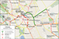
Variation on the surface


On October 4, 2012, the region presented its design for the above-ground expansion of the inner-city route using high-floor technology. The terminus was then planned on Berliner Allee at Platz der Kaufmann. The main station (Ernst-August-Platz) stop is to be placed in Kurt-Schumacher-Strasse in front of the Ernst-August-Galerie and no longer, as initially planned, in the so-called post tunnel underpass of the Lister Meile. A new station on Berliner Allee at Raschplatz should make it easier to change to the underground station on the A and B lines. The Raschplatz-Hochstrasse was to be demolished according to these plans. The expansion should cost a total of 63 million euros including the demolition of the elevated road.
Criticism arose from several quarters against these plans, in particular it appeared questionable whether the demolition of the elevated road would be supported by the state. After it became clear that there would be no state funding for the cost of the demolition of the elevated road, the region decided to forego the demolition and to have the route end on the Lister Meile at the level of the central bus station.
Low-floor supplementary network
In the early 1990s, discussions were held about converting the network to low-floor vehicles or a supplementary low-floor tram network. Accordingly, the route from Limmer across the Aegi was to be extended past the Maschsee to the stadium bridge and the former zoo route through Königstrasse was to be supplemented by a branch via Bödekerstrasse and Ferdinand-Wallbrecht-Strasse to Niedersachsenring. Above all, the cost of converting the existing elevated platforms, especially in the tunnel stations, whose platforms and substructures are partially load-bearing elements, spoke against a complete conversion.
The low-floor plans were taken up again on the occasion of the planning for an elevated platform in Limmerstrasse in 2009. It was discussed whether line 10 could be converted to a low-floor system. As a result, üstra commissioned an expert opinion to examine the possibilities and costs of an additional low-floor network. The appraisal put the additional investment in vehicles, workshop and bus stops compared to the conventional high-floor system at EUR 8.5 million; the annual additional costs in operation were EUR 900,000. A working group commissioned by the region came to the conclusion that a separate low-floor system would cause additional costs of 500,000 to 1,000,000 euros per year compared to the high-floor system. The region then decided to expand the line in the existing high-floor system, which led to the TenSeventeen project .
literature
- Achim Uhlenhut: Local transport in Hanover . GeraNova Zeitschriftenverlag, Munich 2000, ISBN 3-89724-703-8 .
- Dieter Eisfeld: City and local public transport: The case of Hanover 1852-2000 . ÜSTRA, Hannover, 2001, ISBN 3-9802783-0-1 (graphical on p. 51 Network development).
- Peter Sohns: Line chronicle of the tram and light rail Hanover 1872-2003 . Working group Blickpunkt Straßenbahn, Berlin 2003, ISBN 3-926524-22-7 .
- Horst Moch: Tram in Hanover . Kenning Verlag, Nordhorn 2004, ISBN 3-933613-45-0 .
- Robert Schwandl: Hannover Stadtbahn Album . Robert Schwandl Verlag, Berlin 2005, ISBN 3-936573-10-7 .
- Dieter Apel u. a .: Right in the middle instead of underneath, above-ground light rail line D - Impulse for the City 2020 . BIU and VCD, Hannover 2009, ISBN 978-3-922883-26-5 .
- Frank Stiefenhofer: The D-Line - development concepts for a light rail line in Hanover and its effects on the city center . Diplomica Verlag, Hamburg 2009, ISBN 978-3-8366-3299-7 .
- Michael Narten, Achim Uhlenhut: 125 years of Üstra: Out and about in Hanover . Leuenhagen & Paris, Hannover 2017, ISBN 978-3-945497-04-3 .
Web links
- üstra homepage
- Stadtbahn mit System , üstra brochure 2000 (PDF file; 908 kB)
- Getting on: The tram , üstra brochure August 2008 (PDF file; 991 kB)
- Infra , information, plans and photos on current light rail construction work
- Local transport plan
- Stadtbahn Hannover , private website
- Track plan of the Hannover Stadtbahn , private website
Individual evidence
- ↑ Details. April 25, 2017. Retrieved January 18, 2018 .
- ↑ pro-d-tunnel.de subway network planning of the city of Hanover
- ↑ pro-d-tunnel.de subway network planning of the city of Hanover
- ↑ Reports on the use of federal financial aid to improve traffic conditions in the municipalities in accordance with the Municipal Transport Financing Act (GVFG report) ( Memento of October 2, 2013 in the Internet Archive )
- ↑ U-Bahn network planning of the city of Hanover, January 1966, accessed on June 30, 2011 (PDF; 21.7 MB)
- ↑ a b üstra brochure 30 years of tunnels (PDF; 619 kB)
- ↑ Deutsche Bahn AG (Ed.): “Competition Report 2007”, Berlin 2007, p. 20. yumpu.com
- ↑ Uestra image brochure. Retrieved December 9, 2018 .
- ↑ Infra Hannover : Stadtbahn extension to Misburg / Nord - Schierholzstraße ( memento of September 27, 2013 in the Internet Archive ), accessed on November 14, 2010.
- ↑ Stadtbahn to Misburg, infra ( Memento from September 27, 2013 in the Internet Archive ) (PDF; 172 kB)
- ↑ Misburg has a rail connection again , Hannoversche Allgemeine Zeitung of December 14, 2014.
- ↑ Information from the City of Hanover on the construction of the new bridge, accessed on January 16, 2009 ( Memento from July 18, 2010 in the Internet Archive )
- ↑ ( page no longer available , search in web archives )
- ↑ a b A new tunnel for the light rail? Hannoversche Allgemeine Zeitung from March 3, 2009
- ↑ Project TENSEEN | INFRA GmbH. In: www.infra-hannover.de. Retrieved November 19, 2016 .
- ↑ The schedule for the construction of the D line is set . Hannoversche Allgemeine Zeitung of May 30, 2013
- ^ Hannoversche Allgemeine Zeitung, Hanover, Lower Saxony, Germany: Steintor will be a major construction site for four months - HAZ - Hannoversche Allgemeine. Retrieved April 10, 2017 .
- ^ Neue Presse, Hanover, Lower Saxony, Germany: Traffic - elevated platform "Rosenstrasse" doesn't get a roof for almost a year - NP - Neue Presse. In: www.neuepresse.de. Retrieved November 19, 2016 .
- ^ Resolution printed matter from the Hanover region of April 30, 2015 : Future of the Ricklinger Strasse and Humboldtstrasse stops
- ↑ https://www.uestra.de/unternehmen/presse-medien/pressemitteilungen/details/2019/bauarbeiten-im-bereich-humboldtstrasse-linie-17-entfaellt-am-dienstag-13-august-komplett/
- ↑ https://www.uestra.de/unternehmen/presse-medien/pressemitteilungen/details/2020/neubau-und-sanierung-von-hochbahnstieg-humboldtstrasse-entfaellt-lortzingstrasse- geht-in-betrie /
- ↑ üstra press release of December 9, 2015: New timetables from December 13, 2015
- ↑ eVIT_net - the project server for eVIT projects on the Internet. (No longer available online.) In: evit-net.de. Archived from the original on December 22, 2015 ; accessed on December 16, 2015 . Info: The archive link was inserted automatically and has not yet been checked. Please check the original and archive link according to the instructions and then remove this notice.
- ↑ Bike + Ride 2.0 | Traffic planning & development | Mobility | Living in the Hanover Region | Hannover.de | Home - hannover.de. Retrieved September 12, 2019 .
- ↑ Local transport plan 2015, Chapter C 1.2 to 1.4: Operating performance and traffic performance
- ^ Draft for the 2020 local transport plan, Chapter 2.1
- ↑ Tw 601 of the Edmonton Radial Railway Society
- ↑ üstra on May 24, 2013: Friends' association is looking for donors: prototype of the light rail is to return home from Canada
- ^ Hannoversche Allgemeine Zeitung, Hanover, Lower Saxony, Germany: 40-year-old Üstra car returns to Hanover - HAZ - Hannoversche Allgemeine. In: Hannoversche Allgemeine Zeitung. Retrieved September 18, 2016 .
- ↑ Förderverein STRASSENBAHN HANNOVER eV - home page. In: www.strassenbahn-hannover.de. Retrieved September 18, 2016 .
- ^ Hannoversche Allgemeine Zeitung, Hanover, Lower Saxony, Germany: Üstra tram TW 601 is back in Hanover - HAZ - Hannoversche Allgemeine. In: Hannoversche Allgemeine Zeitung. Retrieved October 19, 2016 .
- ↑ https://www.uestra.de/unternehmen/presse-medien/pressemitteilungen/details/2018/zukunftsoffensive-im-nahverkehr-hannover-bekom-sieben-zusaetzliche-neue-stadtbahnen/
- ↑ https://www.uestra.de/unternehmen/presse-medien/pressemitteilungen/details/2018/stadtbahnflotte-waechst-der-hundste-tw-3000-faehrt-auf-hannovers-schienen/
- ↑ 40 green light rail vehicles are to be replaced. Hannoversche Allgemeine Zeitung from December 6, 2018
- ↑ Hannoversche Allgemeine Zeitung of March 6, 2009, p. 13.
- ↑ üstra press release of June 4, 2009 with visualizations ( Memento of April 13, 2011 in the Internet Archive )
- ↑ pressebox.de
- ↑ https://www.uestra.de/unternehmen/presse-medien/pressemitteilungen/details/2018/zukunftsoffensive-im-nahverkehr-hannover-bekom-sieben-zusaetzliche-neue-stadtbahnen/
- ↑ üstra press release from November 14, 2013
- ↑ Commissioning of the TW 3000
- ↑ HAZ of August 25, 2014: New light rail vehicles are threatened with the scrapyard
- ↑ https://www.uestra.de/unternehmen/presse-medien/pressemitteilungen/details/2019/frischzellenkur-fuer-den-tw-6000-hannovers-ertse-stadtbahnen-uchten-in-frischem-gruen/
- ↑ https://www.uestra.de/unternehmen/presse-medien/pressemitteilungen/details/2019/beschluss-des-aufsichtsrats-uestra-endet-verkehrswende-vor/
- ↑ https://regions-sitzungsinfo.hannit.de/bi/to020.asp?TOLFDNR=1031144
- ↑ https://regions-sitzungsinfo.hannit.de/bi/vo020.asp?VOLFDNR=1007328
- ↑ Bergens Tidende of June 18, 2010 (Norwegian)
- ↑ https://www.haz.de/Hannover/Aus-der-Stadt/Die-Infra-in-Hannover-gibt-Gas-Vier-neue-Hochbahnsteige-fuer-die-Stadtbahn-2020
- ↑ Infra on July 16, 2014: Hemmingen-Westerfeld - tram extension ( memento of the original from November 22, 2014 in the Internet Archive ) Info: The archive link was inserted automatically and has not yet been checked. Please check the original and archive link according to the instructions and then remove this notice. , ( Part 1 of the decision as PDF )
- ↑ all around us edition 2013/01/01 - 50th volume, 9 January 2013, page 7
- ↑ Infrastructure plan for the Hemmingen tram extension ( Memento from February 17, 2013 in the web archive archive.today )
- ^ Hemmingen-Westerfeld - tram extension. In: infra Hannover GmbH. July 13, 2017, accessed on July 2, 2019 (German).
- ^ Resolution printed matter No. 1000 (III) BDs of the Hanover region of May 14, 2013
- ↑ Infra on July 16, 2014: Tram connection for Hemmingen ( Memento of the original from November 22, 2014 in the Internet Archive ) Info: The archive link was automatically inserted and not yet checked. Please check the original and archive link according to the instructions and then remove this notice.
- ^ A-south urban railway line: extension to Hemmingen - implementation and financing
- ↑ regions-sitzungsinfo.hannit.de
- ↑ http://www.haz.de/Umland/Hemmingen/Stadtbahnverlaengerung-nach-Hemmingen-Westerfeld-erst-im-jahr-2023-Infra-informiert-im-Ausuß
- ↑ Details. August 16, 2018, accessed July 2, 2019 .
- ^ Hemmingen-Westerfeld - tram extension. In: infra Hannover GmbH. July 13, 2017, accessed on July 2, 2019 (German).
- ↑ Andreas Zimmer: L 389 will be closed for four weeks. Hannoversche Allgemeine, July 18, 2019, accessed on August 19, 2019 .
- ↑ Local transport plan 2015 for the Hanover region
- ↑ The tram should run to the center of Garbsen (Hannoversche Allgemeine Zeitung, June 4, 2016)
- ↑ Hannoversche Allgemeine Zeitung of June 26, 2012.
- ↑ Elevated platforms expressly desired, HAZ dated December 5, 2014
- ↑ Local transport plan 2015, p. 242
- ↑ http://www.haz.de/Hannover/Aus-der-Stadt/MHH-Neubau-in-Hannover-Interview-mit-Ulf-Birger-Franz-wegen-der-Stadtbahn
- ↑ http://www.neuepresse.de/Hannover/Meine-Stadt/MHH-Bahn-Wer-muss-zahlen
- ↑ The tram will not travel to Ikea on the Expo site until 2019. Hannoversche Allgemeine Zeitung from January 18, 2016
- ↑ regions-sitzungsinfo.hannit.de
- ↑ https://regions-sitzungsinfo.hannit.de/bi/vo020.asp?VOLFDNR=1007328
- ↑ regions-sitzungsinfo.hannit.de
- ↑ regions-sitzungsinfo.hannit.de
- ↑ Local transport plan 2015, Chapter E III 3.3.2: Retrofit program for elevated platforms
- ↑ http://regions-sitzungsinfo.hannit.de/bi/vo020.asp?VOLFDNR=1006589
- ↑ https://www.neuepresse.de/Hannover/Meine-Stadt/Das-Thema-ist-durch-Limmerstrasse-bekommen-drei-Hochbahnsteige
- ↑ https://www.haz.de/Hannover/Aus-den-Stadtteile/Ost/Hannover-Bothfeld-Bothfeld-soll-bis-2022-einen-Hochbahnsteig-bekommen
- ↑ https://www.infra-hannover.de/bothfeld/
- ↑ http://regions-sitzungsinfo.hannit.de/bi/vo020.asp?VOLFDNR=1007098
- ↑ http://www.haz.de/Umland/Laatzen/Laatzen-Gleidingens-erster-Hochbahnsteig-soll-schon-2022-verbind-sein
- ↑ https://regions-sitzungsinfo.hannit.de/bi/vo020.asp?VOLFDNR=1007343
- ↑ Infraprojekt ten seventeen
- ↑ https://www.haz.de/Hannover/Aus-der-Stadt/Die-Infra-in-Hannover-gibt-Gas-Vier-neue-Hochbahnsteige-fuer-die-Stadtbahn-2020
- ↑ Infra Hochbahnsteig Stadthalle ( Memento of the original from March 9, 2016 in the Internet Archive ) Info: The archive link was inserted automatically and has not yet been checked. Please check the original and archive link according to the instructions and then remove this notice.
- ↑ https://www.infra-hannover.de/hccstadthalle/
- ↑ http://regions-sitzungsinfo.hannit.de/bi/vo020.asp?VOLFDNR=1006580
- ↑ New Hemmingen line ( Memento of the original from November 22, 2014 in the Internet Archive ) Info: The archive link was automatically inserted and not yet checked. Please check the original and archive link according to the instructions and then remove this notice.
- ↑ http://www.haz.de/Umland/Hemmingen/Stadtbahnverlaengerung-nach-Hemmingen-Westerfeld-erst-im-jahr-2023-Infra-informiert-im-Ausuß
- ↑ https://e-government.hannover-stadt.de/lhhsimwebre.nsf/DS/0622-2018
- ↑ https://regions-sitzungsinfo.hannit.de/bi/vo020.asp?VOLFDNR=1006581
- ↑ https://myorder.rib.de/public/publications/301387
- ↑ Infra elevated platform Humboldtstrasse
- ↑ regions-sitzungsinfo.hannit.de
- ↑ https://regions-sitzungsinfo.hannit.de/bi/vo020.asp?VOLFDNR=1006444
- Jump up ↑ Infra elevated platform kurz-Kamp-Straße
- ↑ http://regions-sitzungsinfo.hannit.de/bi/vo020.asp?VOLFDNR=1007099
- ↑ Region session info
- ↑ https://www.neuepresse.de/Hannover/Meine-Stadt/Das-Thema-ist-durch-Limmerstrasse-bekommen-drei-Hochbahnsteige
- ↑ https://www.infra-hannover.de/ausbaukonzept-fuer-laatzen-rethen/
- ↑ https://www.infra-hannover.de/rethennord-rethenpattenser-strasse/
- ↑ Infra elevated platform Rethen / Galgenbergweg
- ↑ https://planfeststellung.strassenbau.niedersachsen.de/verf?action=1&prj=1501
- ↑ http://regions-sitzungsinfo.hannit.de/bi/vo020.asp?VOLFDNR=1006592
- ↑ https://e-government.hannover-stadt.de/lhhsimwebre.nsf/DS/0622-2018
- ↑ https://regions-sitzungsinfo.hannit.de/bi/vo020.asp?VOLFDNR=1006581
- ↑ https://e-government.hannover-stadt.de/lhhsimwebre.nsf/DS/0622-2018
- ↑ https://regions-sitzungsinfo.hannit.de/bi/vo020.asp?VOLFDNR=1006581
- ↑ New Hemmingen line ( Memento of the original from November 22, 2014 in the Internet Archive ) Info: The archive link was automatically inserted and not yet checked. Please check the original and archive link according to the instructions and then remove this notice.
- ↑ http://www.haz.de/Umland/Hemmingen/Stadtbahnverlaengerung-nach-Hemmingen-Westerfeld-erst-im-jahr-2023-Infra-informiert-im-Ausuß
- ↑ Region session info
- ↑ https://www.neuepresse.de/Hannover/Meine-Stadt/Das-Thema-ist-durch-Limmerstrasse-bekommen-drei-Hochbahnsteige
- ↑ http://regions-sitzungsinfo.hannit.de/bi/vo020.asp?VOLFDNR=1006593
- ↑ New Hemmingen line ( Memento of the original from November 22, 2014 in the Internet Archive ) Info: The archive link was automatically inserted and not yet checked. Please check the original and archive link according to the instructions and then remove this notice.
- ↑ http://www.haz.de/Umland/Hemmingen/Stadtbahnverlaengerung-nach-Hemmingen-Westerfeld-erst-im-jahr-2023-Infra-informiert-im-Ausuß
- ↑ http://regions-sitzungsinfo.hannit.de/bi/vo020.asp?VOLFDNR=1006566
- ↑ https://regions-sitzungsinfo.hannit.de/bi/vo020.asp?VOLFDNR=1007328
- ↑ Printed matter No. 1994/2008 City of Hanover
- ↑ https://regions-sitzungsinfo.hannit.de/bi/vo020.asp?VOLFDNR=1006421
- ↑ [1]
- ↑ https://regions-sitzungsinfo.hannit.de/bi/vo020.asp?VOLFDNR=1007643
- ↑ https://regions-sitzungsinfo.hannit.de/bi/vo020.asp?VOLFDNR=1007643
- ^ Infra - expansion of the Schulenburger Landstrasse
- ^ Elevated platforms expressly desired , Hannoversche Allgemeine Zeitung of December 7, 2014.
- ↑ Expansion of Badenstedter Strasse. In: infra-hannover.de . infra Infrastrukturgesellschaft, 2017, accessed on June 19, 2020 .
- ^ Resolution printed matter of the Hanover region dated May 21, 2012
- ↑ http://www.haz.de/Umland/Laatzen/Laatzen-Gleidingens-erster-Hochbahnsteig-soll-schon-2022-verbind-sein
- ↑ Local transport plan 2015, p. 240
- ↑ Too expensive - no tram to Davenstedt. In: Hannoversche Allgemeine Zeitung. Accessed December 15, 2015 (German).
- ↑ Short presentation of the economic efficiency calculation Davenstedt
- ↑ Transport Committee of February 27, 2014 Annex to Item 4: Tram connection to the Garbsen mechanical engineering campus
- ↑ Regional meeting information: New construction of a bus stop for the mechanical engineering campus
- ↑ These are the tunnel dreams of the üstra, Neue Presse of December 9, 2006
- ↑ Homepage Initiative Pro D-Tunnel e. V.
- ↑ Only visible local transport brings the city center to life , Hannoversche Allgemeine Zeitung of March 4, 2009, p. 17.
- ↑ Expansion of the D line costs 63 million euros. Hannoversche Allgemeine Zeitung from October 4, 2012
- ↑ Tram line 10 - low floor or high floor? | Latest news | Bus & Train | Mobility | Living in the Hanover Region | Hannover.de | Home - hannover.de. In: www.hannover.de. Retrieved August 31, 2016 .
- ^ Hannoversche Allgemeine Zeitung of February 17, 2010
- ↑ Assessment result for tram route D
Bielefeld | Frankfurt am Main | Hanover | Karlsruhe (under construction) | Rhine-Ruhr ( Bochum | Dortmund | Düsseldorf | Duisburg | Essen ) | Rhine victory ( Bonn | Cologne ) | Stuttgart