Laatzen center
|
Laatzen center
City of Laatzen
|
||
|---|---|---|
| Coordinates: 52 ° 18 ′ 26 ″ N , 9 ° 48 ′ 54 ″ E | ||
| Height : | 67 m above sea level NHN | |
| Area : | 2.85 km² | |
| Residents : | 17,483 (22 Aug 2017) | |
| Population density : | 6,134 inhabitants / km² | |
| Incorporation : | March 1, 1974 | |
| Postal code : | 30880 | |
| Area code : | 0511 | |
|
Location of Laatzen-Mitte in Lower Saxony |
||
|
Laatzen-Mitte as a village of Laatzen
|
||
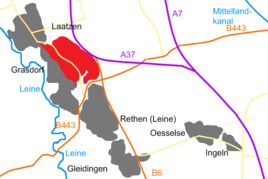
Laatzen-Mitte is a village in the city of Laatzen in the Hanover region .
history
Laatzen-Mitte is the youngest part of the city of Laatzen. While the other districts of Alt-Laatzen , Grasdorf , Rethen , Ingeln-Oesselse and Gleidingen were historically grown localities, the district of Laatzen-Mitte was created on the drawing board in the 1970s. The district conceived as a new city center is characterized by the Leine-Center (formerly Leine-Shopping-Center) and the new town hall as well as the surrounding multi-story residential buildings.
The redevelopment of the district began in 2004 as part of the federal-state program for the Social City . In addition to urban development measures , social, economic and ecological improvements also play a role.
politics
Local councilor and local mayor
At the municipal level, Laatzen-Mitte is represented by the local council of the core town of Laatzen.
coat of arms
The design of the Laatzen-Mitte coat of arms is of unknown origin.
- The approval of the coat of arms was granted by the President of the Province of Hanover in 1930/31.
- The city of Laatzen, newly formed by law on March 1, 1974, took over the coat of arms of the previous city of Laatzen, which was approved by the district president in Hanover on April 30, 1974.
| Blazon : "In the divided shield above on a red background a growing , golden lion and below on green a silver wave bar ." | |
| Justification of the coat of arms: When designing the coat of arms of the upper half of the shield, it was assumed that today's Laatzen district of the city of the same name, together with the current Hanoverian districts of Wülfel and Döhren, belonged to the so-called "Small Free", the old judicial association of the three then independent municipalities. This area in turn formed part of the so-called "Great County" and passed in 1248 from the Counts of Lauenrode to the Welfs . Both sexes, the Counts of Lauenrode and the Dukes of Braunschweig-Lüneburg , have a soaring lion in their coat of arms. Since the rule of the Lauenroder counts in the Kleiner Free area ended in 1248, the Guelph lion was certainly thought of when designing the coat of arms. The silver wave bar on a green background in the lower half of the shield is intended to symbolize Laatzen's position on the leash embedded in green meadows. |
Culture and sights
The Park of the Senses is a park on a former garbage dump on Erich-Panitz-Straße that was created as part of the EXPO project Regional Landscape Area on Kronsberg .
The "DIE ARCHE" community center on Marktstrasse, completed in 1978, and the St. Thomas Kindergarten on Otto-Hahn-Strasse belong to the Evangelical Lutheran Thomas parish. The parish belongs to the Laatzen region in the Laatzen-Springe parish of the regional church of Hanover .
The Catholic parish church of St. Oliver is located on Pestalozzistraße. It was built in 1975-77 and named after Oliver Plunkett . Her parish of the same name belongs to the dean's office in Hanover, and the Catholic churches in Alt-Laatzen and Gleidingen also belong to it today .
Economy and Infrastructure
Laatzen-Mitte lies in the area of the former Grasdorfer Feldmark and is bordered in the east by the Messeschnellweg , the B6 . In the west and north, the Hanover - Hildesheim line forms the border with Grasdorf and Alt-Laatzen . In the south, the B443 marks the border with the Laatzener district of Rethen.
In 1973 a tram line was built from Hildesheimer Strasse along Erich-Panitz-Strasse to the LVA . The line was extended to Rethen in 1976 and connected to the local line to Sarstedt. Today the tram line 1 runs here (Langenhagen - Hannover Hbf - Laatzen - Sarstedt). In addition, bus lines 340/341 go to Expo Park and Pattensen , bus line 346 connects Laatzen-Mitte with Grasdorf and Rethen.
- education
In Laatzen-Mitte there are two elementary schools, Pestalozzistraße and Im Langen Feld.
Three of the four secondary schools in Laatzen are located here: the Erich-Kästner - Gymnasium (formerly the Gymnasium Laatzen), the Erich-Kästner-Realschule and the KGS Albert-Einstein- School. They are open to students from all parts of the city of Laatzen.
With the school on Kiefernweg, the city of Laatzen in Laatzen-Mitte maintains a special needs school focusing on learning . In addition to the special school qualification, the secondary school qualification can also be obtained at this school.
The Laatzen city library is located in the town hall. Since 2005 it has focused on promoting reading for children and young people. The city library has around 30,000 items that can be borrowed, including console games, DVDs and audio books.
Web links
Individual evidence
- ^ Main statute for the city of Laatzen , laatzen.de
- ↑ a b District Hanover: Wappenbuch district Hanover. Published by the author himself, Hanover 1985.


