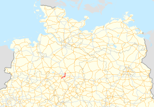
Bundesstrasse 443
| Bundesstrasse 443 in Germany | |

|
|
| map | |
| Basic data | |
| Operator: |
|
| Start of the street: |
Pattensen ( 52 ° 16 ′ N , 9 ° 47 ′ E ) |
| End of street: |
Burgdorf ( 52 ° 28 ′ N , 9 ° 59 ′ E ) |
| Overall length: | 36 km |
|
State : |
|
|
Course of the road
|
|
The federal highway 443 (abbreviation: B 443 ) is a federal highway in Lower Saxony, southeast of Hanover . It connects the cities of Pattensen , Laatzen , Hanover, Sehnde , Lehrte and Burgdorf in the Hanover region . It also serves as an important feeder to the Hanover exhibition center .
The B 443 connects the following trunk roads:
- B 3 at Pattensen
- B 6 near Laatzen- Rethen (also Messeschnellweg )
- A 7 at the municipal border Hannover / Sehnde near Hannover- Wülferode and Sehnde- Wassel
- B 65 in Sehnde
- A 2 at Lehrte
- B 188 (near Burgdorf)
- A 37 and B 3 indirectly via B 188 and K 120
Planning
The Federal Transport Infrastructure Plan 2003 lists the construction of a bypass around Gestorf as an additional requirement ; In this context, the B 443 should be extended from the B 3 near Pattensen to the B 217 near Springe . As of February 2016, no implementation was in sight. The Federal Transport Infrastructure Plan 2030 does not contain this measure and, however, assesses a bypass of Koldingen as an urgent need.
See also
Web links
Individual evidence
- ↑ Federal Transport Infrastructure Plan 2003 for Lower Saxony , page from the Federal Ministry of Transport and Digital Infrastructure , accessed on March 6, 2014
- ↑ Dossier. Project number: B443-G20-NI, project name: B 443 OU Koldingen. In: www.bvwp-projekte.de. Retrieved March 27, 2016 .
- ↑ Federal Law Gazette . Retrieved August 31, 2017 .
