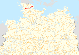
Bundesstrasse 201
| Bundesstrasse 201 in Germany | ||||||||||||||||||||||||||||||||||||||||||||||||||||||||||||||||||||||||||||||||||||||||||||||||||||

|
||||||||||||||||||||||||||||||||||||||||||||||||||||||||||||||||||||||||||||||||||||||||||||||||||||
| map | ||||||||||||||||||||||||||||||||||||||||||||||||||||||||||||||||||||||||||||||||||||||||||||||||||||
| Basic data | ||||||||||||||||||||||||||||||||||||||||||||||||||||||||||||||||||||||||||||||||||||||||||||||||||||
| Operator: |
|
|||||||||||||||||||||||||||||||||||||||||||||||||||||||||||||||||||||||||||||||||||||||||||||||||||
| Start of the street: |
Husum ( 54 ° 29 ′ N , 9 ° 4 ′ E ) |
|||||||||||||||||||||||||||||||||||||||||||||||||||||||||||||||||||||||||||||||||||||||||||||||||||
| End of street: |
Kappeln ( 54 ° 40 ′ N , 9 ° 55 ′ E ) |
|||||||||||||||||||||||||||||||||||||||||||||||||||||||||||||||||||||||||||||||||||||||||||||||||||
| Overall length: | 63 km | |||||||||||||||||||||||||||||||||||||||||||||||||||||||||||||||||||||||||||||||||||||||||||||||||||
|
State : |
||||||||||||||||||||||||||||||||||||||||||||||||||||||||||||||||||||||||||||||||||||||||||||||||||||
| Development condition: | two-lane | |||||||||||||||||||||||||||||||||||||||||||||||||||||||||||||||||||||||||||||||||||||||||||||||||||
|
Course of the road
|
||||||||||||||||||||||||||||||||||||||||||||||||||||||||||||||||||||||||||||||||||||||||||||||||||||
The federal highway 201 (abbreviation: B 201 ) is an east-west connection of Schleswig-Holstein in the state of Schleswig . It leads from Husum to Kappeln .
course
At the eastern exit of the North Frisian district town of Husum , the local Schleswiger Chaussee merges directly with the B 201. This initially leads via Schwesing , Wester-Ohrstedt , Oster-Ohrstedt , Treia , Silberstedt and Schuby into the Schleswig area.
In the further course (east of the motorway junction no. 5 ( Schleswig / Schuby ) of the A 7 ) it forms the northern bypass of the city of Schleswig beyond the intersection with the B 76 . It is initially developed without any elevation . In the further course it leads north of the Schlei on the south-eastern outskirts of Tolk past Grumby , Loit and Brebel to Süderbrarup and finally on to Kappeln . At the junction with the B 199 at the entrance to the village, it leads directly over to the B 203 towards Eckernförde.
- Branch-off / crossing traffic and waterways
- B 5 in Husum
- Treene in Treia
- A 7 in Schuby
- B 76 in Schuby
- Loiter Au in Loit / Twedt
- B 199 in Kappeln
- B 203 also in Kappeln

