
Federal road 498
| Bundesstrasse 498 in Germany | |

|
|
| map | |
 |
|
| Basic data | |
| Operator: |
|
| Start of the street: |
Goslar ( 51 ° 55 ′ N , 10 ° 27 ′ E ) |
| End of street: |
Osterode am Harz ( 51 ° 44 ′ N , 10 ° 16 ′ E ) |
| Overall length: | 39 km |
|
State : |
|
 |
|
| View of the federal highway 498 in the Okertal near Romkerhalle from the Ahrendsberger cliffs | |
|
Course of the road
|
|
The federal highway 498 (abbreviation: B 498 ) is a German federal highway . It leads from Goslar to Osterode am Harz .
course
The B 498 initially branches off in the urban area of Goslar west of Sudmerberg as an exit from the motorway-like federal highway 6 .
After a few hundred meters, "Okerstraße" branches off to the west and connects to federal highway 82 . Until 1987, instead of the B 498, the B 6 ran to Bad Harzburg from here . Shortly after entering the district of Oker , the federal road runs under the name "Im Schleeke" for about two kilometers between the HC Starck facility in the south and the Sudmerberg in the north with its distinctive transmitter mast . Then the B 498 runs as "Bahnhofstraße" past the Oker station and crosses under the Vienenburg – Goslar and Oker – Bad Harzburg railway lines , before the old B 6 branches off to the east as the L 501 towards Göttingerode at the roundabout just before the Harz .
Then the B 498 follows the course of the Oker into the Upper Harz and runs through the deeply cut Oker valley, with slopes up to 300 m high from the Oker level. The main road passes the Kästeklippe (605 m above sea level) and the Romkerhaller waterfall and after about 7 km reaches the dam of the Okertalsperre . There are several places for excursions between the main road and the reservoir. The road to Schulenberg im Oberharz and Clausthal-Zellerfeld branches off before the B 498 crosses the Oker dam on a bridge and follows its course for another 4 km. Then Altenau is crossed with a connection to the high altitude village of Torfhaus (850 m above sea level) about 8 km away . At Sperberhaier Dammhaus, the B 498 has a short common course with the Bundesstraße 242 (Harzhochstraße) between Clausthal-Zellerfeld and Braunlage-Oderbrück, but then bends in a southerly direction.
The section south of Riefensbeek-Kamschlacken is only rudimentary and in terms of its minor traffic importance cannot be compared with the federal highway 241 running to the west . The B 498 runs over the dam, along the Sösetalsperre and leaves the Harz shortly before reaching Osterode am Harz , where it ends at Bundesstraße 241.
Local authorities
-
Lower Saxony
-
District of Goslar
- City of Goslar: OK
- Mountain and university town Clausthal-Zellerfeld : Altenau
- Dam house
-
District of Göttingen
- City of Osterode am Harz: Riefensbeek-Kamschlacken , Osterode am Harz
-
District of Goslar
Waters crossed
- Breeding , at Sudmerberg
- Oker , in Oker and Romkerhalle
- Okertalsperre , near Altenau
- Dam ditch , at the Sperberhaier dam
- Söse , in Riefensbeek-Kamschlacken
- Sösetalsperre , near Riefensbeek-Kamschlacken
history

The federal highway 498 was set up on January 1st, 1967 to improve the network of federal highways. Most likely it also served to better develop the areas in front of the inner-German border .
The B 498 originally began within Oker on what was then the B 6. When it was relocated to the B 6n in 1983 , the B 498 was relocated to the former course of the B 6, which means that it is now connected twice to the federal highway 241 .
In August 2017, an LED installation in rainbow colors was installed below the railway underpass on the side of the road towards Goslar. The lighting should contribute to a brighter and friendlier lighting. The financing came from the city of Goslar as well as sponsorship money.
Attractions
- LED installation east of Oker train station
- Okertal and Okertalsperre between Altenau and Oker
- Upper Harz water shelf , between Altenau and Riefensbeek-Kamschlacken
- Sösetalsperre, near Riefensbeek-Kamschlacken
photos

The B 498 in Kamschlacken

At Sperberhaier Damm, the B 498 crosses with the B 242

The B 498 in the Okertal near Romkerhalle
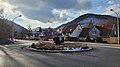
Roundabout with the state road L 501 (Harzburger Straße) in Oker
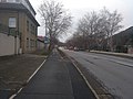
The B 498 parallel to the main building of HC Starck in Oker


See also
Individual evidence
- ↑ See Bundesstrasse 499 ; contained in the German General Atlas 1967/68 , accessed on December 28, 2019.
- ↑ City of Goslar : Tunnel now shines in rainbow colors: New LED lighting in the railway underpass in Oker . August 22, 2017. Retrieved October 23, 2019.
Coordinates: 51 ° 48 ′ 12.5 ″ N , 10 ° 26 ′ 50 ″ E