
Oker (Goslar)
|
Oker
City of Goslar
|
||
|---|---|---|
_COA.svg) |
||
| Height : | 208 (188-297) m above sea level NHN | |
| Residents : | 5715 (June 30, 2018) | |
| Incorporation : | July 1, 1972 | |
| Postal code : | 38642 | |
| Area code : | 05321 | |
Location of Oker in Lower Saxony |
||
.JPG) View of Oker from the south
|
||

Oker [ ˈoːˌkɐ ] is a district of Goslar am Harz in the Goslar district in Lower Saxony and 3.5 km east of the core area of Goslar. With 5,715 inhabitants (as of June 30, 2018), Oker is one of the large towns in the Goslar urban area and has a pronounced degree of cultural independence.
The town, named after the river Oker , was founded in 1527 as a smelting place and was decisive for the processing of the ores from the Rammelsberg . Oker was a weighty center of the Harz metallurgy (see lead smelter Oker , Zinkoxydhütte Oker and zinc smelter Harlingerode ) and strongly influenced today by its coal and steel industry past.
geography
Geographical location
The village is located at the exit of the Oker valley between Hahnenberg and Adenberg in the south, Sudmerberg in the northwest and Langenberg / Tönneckenkopf in the east.
Neighboring places
|
Sudmerberg Ohlhof Jürgenohl |
Immenrode | Vienenburg |
|
Georgenberg Goslar |
.svg)
|
Harlingerode |
| Romkerhalle |
Göttingerode Bündheim Bad Harzburg |
Contaminated sites
The soils in Oker are heavily polluted with lead , zinc , copper and cadmium (values over 10 ppm / kg topsoil) due to the centuries of smelting history and the Harz ironworks ( lead smelter Oker and others ). A comparable heavy metal load with similar effects ( Gressenich disease ) can be found in the Stolberg - Eschweiler area in North Rhine-Westphalia . In addition, the Oker River is extremely polluted; After the northeastern Feldmark, a plant disease was named in two dissertations as Oker or Steinfeld disease . Therefore, since 1977, on behalf of the Hildesheim trade supervisory authority, deposition measurements have been carried out in the Okeran area, initially including dust deposits and lead and cadmium deposits . In 2009 the measurement repertoire was expanded to include arsenic / nickel and 2011 to include thallium .
Local division
Oker is unofficially divided into Oberoker and Unteroker by the Vienenburg – Goslar / Oker – Bad Harzburg railway . The northern settlement on the eastern edge of the Sudmerberg is sometimes referred to as Steinfeld and the part to the east of Bundesstrasse 498 and south of Harzburger Strasse in the direction of Göttingerode as Adenbergsiedlung .
history

.jpg)
Place name
At first, Oker was vaguely referred to as auf / an der Oker , from which later names such as "the Oker" or "Communion-Oker" developed. It was not until the 19th century that the village was generally referred to as Oker without any additions .
The adjective and demonym are Okeraner .
The popular etymological assertion that the name for the color ocher was derived from the fact that it was obtained “in the Oker huts” is a legend.
Early history
The oldest historically tangible settlement in the Okers area was the Sudburg between the Oker and the Sudmerberg, and ironworks also have a long tradition in the forests around the Oker. In 1311 the Galmhütte ("de hutte tom Nederen Galm"; Galm = "sound, noise" in relation to gellen ) was first mentioned, which was located in today's Feldmark of Harlingerode ; it was abandoned during the 17th century. In order to process the ores from the Rammelsberg , small smelters, mostly operated by Goslar townspeople, settled there from the 15th century. This led to a long-standing dispute between the Brunswick-Wolfenbüttel duke Heinrich the Younger and the free imperial city of Goslar, in which, however, the operation of the smelters was tolerated. Already in this time the still unspecific pile of settlements was mentioned for the first time as Oker in 1527 . His son and successor, Duke Julius zu Braunschweig-Wolfenbüttel , took possession of all the huts that were in operation during his time in office and formed the later Oberoker from them. The Frau-Marien-Hütte , later known as the Oker lead works, developed into the core of today's Oberoker settlement, while the younger Unteroker comes from a nucleus on the Okerturm. The political unification of the two districts only took place in 1972 with the unification of the two parts in the district of Wolfenbüttel (Brunswick) and the Goslarschen Unteroker to form a district within the city of Goslar.
The founding of the great Ducal Paper Mill at Oker in 1580 was undoubtedly of significant importance for the place . She not only had to deliver certain and relatively large quantities of writing paper for the needs of the princely chancelleries, bookkeeping and armory and also to "all of our Ambtere, Bergk-Saltz and Eisenwergke, also forestry writing ...", but also "so many printing paper, when we need our Julius University in Helmstedt … ”to do this. As a ducal mill, it enjoyed numerous privileges, but given the university's paper needs, it was overwhelmed and soon became one of the three paper mills that were temporarily committed to the Helmstedt University Printing Works. One of these paper mills was in Räbke am Elm. For centuries, these two important manufacturers and locations of the paper industry in the duchy faced sometimes bitter competition.
Modern times
In 1807, Oker was formed from the former community-free area Kommunion-Oker and the territory of the Frau-Marien-Saiger-Hütte and joined the Harzburg office as a new member community .
In 1819 one was post-expedition of Brunswick Post opened. With the opening of the railway line between Goslar and Vienenburg on March 23, 1866, this was moved to Oker station. For the development of the postal system, see also the Wolfenbüttel-Harzburg postal route .
The previous municipality of Oker was spun off from the Harzburg district on July 26, 1953 and made an independent town in the Wolfenbüttel district. After initial plans to unite Oker with Harlingerode and Göttingerode to form one city Oker, it was incorporated into the district town of Goslar on July 1, 1972, with the parts of Okers that had previously belonged to the city of Goslar.
Population development
After the Second World War , the population of Okers, which was elevated to the status of a town, increased enormously and reached a peak of around 10,000 in the 1950s. In the 2010s, the population remained more or less constant, with fluctuations.
|
Oker population development since 1866 |
||||||
|---|---|---|---|---|---|---|
| development | year | Residents | year | Residents | year | Residents |
 |
1866 | 1,100 | 1950 | 10,000 * | 2016 | 5,763 |
| 1885 | 2,333 | 2006 | 7,282 | 2011 | 5,739 | |
| 1890 | 2,552 | 2012 | 5,704 | 2017 | 5,736 | |
| 1925 | 4.175 | 2013 | 5,667 | 2018 | 5,715 | |
| 1933 | 4,067 | 2014 | 5,661 | |||
| 1939 | 4,744 | 2015 | 5,697 | |||
| Source: 1866/1885, generally before 2011, from 2011. Values as at December 31 of the year, 2016 and 2018 as at June 30. * Estimated value |
||||||
Religions
The Evangelical Lutheran parish of Oker was created in October 2005 through the unification of the two parishes St. Paulus (Unteroker) and Martin Luther (Oberoker). The Martin Luther Church , the older of the two churches, was retained. The Paulus Church, which was only consecrated in 1966, was de-dedicated in 2013 and demolished in the same year. There is also the Catholic St. Konrad Church, consecrated in 1952 ( branch church of the parish of St. Jakobus the Elder in Goslar), and a Turkish-Muslim community (Oberoker).
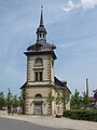
The Martin Luther Church (ev.) In the Hüttenstrasse

St. Conrad of Parzham Church


politics
City Councilor and Mayor
At the municipal level, the district of Oker is represented by the City Council of Goslar.
coat of arms
The design of the coat of arms of Oker comes from the local community. Drawn it has in Isernhagen born and later in Hannover living heraldry and crest painter Gustav nations , which includes the coat of arms of Großburgwedel , Melle village , Wunstorf and many other towns in the region Hannover has designed. The coat of arms was adopted by the council on July 28, 1949 and approval was granted on January 16, 1950 by the Lower Saxony Minister of the Interior .
|
|
Blazon : "In blue over silver waves, a silver watchtower , flanked by two floating silver fir trees and covered with a golden shield with black mallets and irons inside." |
| Justification of the coat of arms: The mountain hammers occupy a place of honor in the coat of arms of Oker because the place emerged from a settlement of miners and smelters . The ore smelting and precious metal extraction in connection with the Harz mining were a basis of existence and partly still are today. The Oker tower shown, which served as a fortification for the Landwehr , is the oldest demonstrable building in the village. The fir trees indicate the tree backdrop on the Harz Heights when the whole area was still covered with forest. Here Duke Julius von Braunschweig had a hut built for the separation of silver and copper in 1527 and thus laid the foundation stone for the Oker settlement. The stylized waves are those of the Oker , after which the former town / town was named. |
Culture and sights
Oker is a historical center of the Harz mining activity. Since the settlement was founded, it has been characterized by the smelting of ore and still has a pronounced mining industrial character. The company premises of HC Starck stretch for kilometers along the federal highway 498 ( Im Schleeke ) and are an example of industrial architecture of the 20th century; the former Oker lead smelter on Kreisstrasse K 70 ( Harlingeroder Strasse ) is a similar example. The recruitment of guest workers in the 20th century had a formative influence on the locality, in particular a strong German-Turkish community is represented in Oker .
Buildings

- Oker lead works (since 1527)
- Martin Luther Church (built from 1823 to 1836)
- Transmitter Goslar on the Sudmerberg
- St. Konrad von Parzham (built from 1951 to 1952)
- Zinc oxide works Oker (built from 1907 to 1909)
- "Goslarer Trojan " (large wooden horse in front of the company pdv-software GmbH (Im Schleeke))
Sports
As a local sports club, VfL Oker has supra-regional importance with its table tennis department and is based in the sports hall named Helmut Sander . The first men's team plays in the Oberliga West and the first women's team in the Regionalliga Nord.
The network of hiking trails around Oker is well developed; There are two sports halls, sports and tennis courts and an outdoor swimming pool in the village itself.
Economy and Infrastructure


economy
Today there are chemical-metallurgical, recycling and special industrial companies in Oker, such as Harz-Metall GmbH and Norzinco . The largest employer in Okers and in the district of Goslar is a plant of the chemical company HC Starck .
traffic
The Oker station is on the Hanover - Hildesheim - Bad Harzburg ( Oker – Bad Harzburg , KBS 320) and Braunschweig - Goslar / Bad Harzburg– Kreiensen ( Vienenburg – Goslar , KBS 353/354) railway lines. There are two hourly connections. Bus routes connect Oker with Goslar and Bad Harzburg. The federal road 498 (Goslar– Osterode am Harz ) runs through Oker . The federal highway 6 ( Cuxhaven - Görlitz ) leads north past Oker today.
Public facilities
There are three kindergartens, a primary school and the Adolf-Grimme-Gesamtschule (an integrated comprehensive school) in the village .
Personalities
Sons and daughters of the place
- Friedrich Ludewig Bouterweck (1766–1828), philosopher and writer
- Karl Friedrich Quittenbaum (1793–1852), physician and university professor
- Julius Hüniken (1824–1891), merchant, shipowner and landowner
- Hermann Breymann (1842–1910), Romanist
- Ernst von Eschwege (1859–1932), forester and painter, from 1897 to 1929 head of the forest administration of Prince Christian Ernst zu Stolberg-Wernigerode
- Friedrich Schucht (1870–1941), university professor for soil science
- Gustav Frölich (1879–1940), agricultural scientist and animal breeder
- Richard Reckewerth (1897–1970), politician (NSDAP)
- Heinrich Preß (1901–1968), hydraulic engineer
- Karl Rowold (1911–1993), resistance fighter and diplomat
- Helge Darnstädt (1925–2009), writer and translator
- Hans-Jörg Klotz (* 1927), doctor of law and director at Mercedes-Benz, managing director of Ullstein Verlag and sports functionary
- Aaron Hunt (* 1986), footballer
People connected to the place
- Justus Friedrich Wilhelm Zachariae (1726–1777), writer, translator and editor as well as composer. In 1767 he received the ducal instruction to “raise domestic paper production” a. a. to tour the paper mill at Oker and make technical improvements to it
- Arnold Breymann (1866–1933), Christian archaeologist and teacher, lived in Oker
- Helmut Sander (1920–1988), local politician and twice mayor of the Lower Saxony city of Goslar, lived in Oker and was a councilor there for eight years
- André Mouton (1924–2017), French writer, former prisoner in the Buchenwald and Dora-Mittelbau concentration camps, participant in the death marches over the Harz Mountains (from Nordhausen via Osterode to Oker), namesake of the André Mouton secondary school in Oker, which later became the Adolf Grimme Comprehensive School has risen
- Jan Benzien (* 1982), canoeist and Olympian, achieved successes in various disciplines at the German championships in Oker in 1998, 2003 and 2006
literature
- Albert Saft: Oker: a chronicle from 1882 to 2007; Events in the city and in the Goslar district of Oker . Verlag Goslarsche Zeitung, 2007, ISBN 3-9809704-6-9 .
- H. Schucht: Chronicle and local history of the Hüttenort Oker . Stolle Verlag, Harzburg 1888.
Web links
Individual evidence
- ↑ a b c The district of Goslar at a glance - figures, data, facts. In: Website of the city of Goslar. Retrieved December 9, 2018 .
- ↑ Heinz-Georg Breuer: Heavy metal: A legacy that is forever in the ground . In: Goslarsche Zeitung . September 6, 2018.
- ↑ Lower Saxony Ministry for the Environment, Energy, Building and Climate Protection : Deposition measurements in Oker-Harlingerode. In: Website of the Lower Saxony Ministry for the Environment, Energy, Building and Climate Protection. Retrieved April 26, 2019.
- ↑ a b Richard Wieries: History of the Office Harzburg to his forest, corridor and street names . Appelhans Verlag, Braunschweig 1937, p. 82 f . ( Digitized version [PDF; 89.3 MB ; accessed on October 3, 2018]).
- ↑ Eberhard Tacke : On the origins and early history of the Oker paper mill. In: Braunschweigische Heimat. 46, year 1960, issue 2, pp. 44-50.
- ↑ Joachim Lehrmann : The early history of the book trade and publishing in the old university town of Helmstedt as well as the history of the once important paper mills at Räbke am Elm and Salzdahlum. Helmstedter and Räbker Book and Paper History, Lehrte 1994, ISBN 978-3-9803642-0-1 . (Pp. 117, 150, 165 ff., 216, 244, 172, 291 ff., 297, 312).
- ^ W. Steven: Table of contents of the postal relevant Braunschweigischen Ciculare, laws and ordinances from 1807 to 1867. Circular letter No. 58, Arbeitsgemeinschaft Braunschweig and Hannover in the Briefmarken-Club Hannover, April 2004.
- ^ Harald Meier, Kurt Neumann: Bad Harzburg. Chronicle of a city. P. 632.
- ^ Federal Statistical Office (ed.): Historical municipality directory for the Federal Republic of Germany. Name, border and key number changes in municipalities, counties and administrative districts from May 27, 1970 to December 31, 1982 . W. Kohlhammer, Stuttgart / Mainz 1983, ISBN 3-17-003263-1 , p. 266 .
- ↑ a b Oker am Harz - the golden question. January 1959. Retrieved October 25, 2018.
- ^ H. Schucht: Chronicle and local history of the Hüttenort Oker . Stolle Verlag, Harzburg 1888 (until 1866 the place, including Schleek and Osterfeld, had about 1100 souls, so the population has more than doubled in 20 years).
- ↑ Michael Rademacher: German administrative history from the unification of the empire in 1871 to the reunification in 1990. goslar.html. (Online material for the dissertation, Osnabrück 2006).
- ↑ Former St. Paul building. In: Internet presence of the parish Oker. Retrieved January 11, 2015.
- ↑ District of Hanover (ed.): Wappenbuch district of Hanover . Self-published, Hanover 1985.
- ^ A b Arnold Rabbow: Braunschweigisches Wappenbuch - With Gandersheim, Gifhorn, Goslar, Helmstedt, Peine, Salzgitter, Wolfenbüttel and Wolfsburg . Eckensberger & Co, Braunschweig 1977, p. 45 .
- ↑ Goslar Trojan , accessed on May 1, 2019

Old town | Bass violin | Georgenberg (with Kattenberg) | Hahndorf (with Grauhof, Gut Grauhof and Kleinsthofsiedlung) | Hahnenklee-Bockswiese (with Hahnenklee and Bockswiese) | Immenrode (with Probsteiburg ) | Jerstedt | Jürgenohl (with Kramerswinkel) | Lengde | Lochtum | Ohlhof (with Gut Ohlhof) | Oker | Rammelsberg (with Siemensviertel and Rosenberg) | Steinberg | Sudmerberg | Vienenburg (with Wöltingerode and Wennerode ) | Weddingen | Reunion