
Isernhagen
| coat of arms | Germany map | |
|---|---|---|

|
Coordinates: 52 ° 27 ' N , 9 ° 53' E |
|
| Basic data | ||
| State : | Lower Saxony | |
| County : | Hanover region | |
| Height : | 58 m above sea level NHN | |
| Area : | 59.76 km 2 | |
| Residents: | 24,315 (Dec. 31, 2019) | |
| Population density : | 407 inhabitants per km 2 | |
| Postal code : | 30916 | |
| Primaries : | 0511, 05136, 05139 | |
| License plate : | H | |
| Community key : | 03 2 41 008 | |
| LOCODE : | DE ISN | |
| Community structure: | 7 districts | |
| Address of the municipal administration: |
Bothfelder Strasse 29 30916 Isernhagen |
|
| Website : | ||
| Mayor : | Arpad Bogya ( CDU ) | |
| Location of the municipality of Isernhagen in the Hanover region | ||
  |
||


Isernhagen is an independent municipality in the Hanover ( Lower Saxony ) region, which is made up of seven districts, including four traditional farmers . The municipality borders the city of Hanover to the northeast in the direction of the cities of Celle and Burgdorf . Isernhagen is the wealthiest municipality in Lower Saxony according to the average income of its citizens.
geography
Isernhagen borders on Burgwedel , Burgdorf , Lehrte , Hanover , Langenhagen and Wedemark (clockwise, starting in the north). Isernhagen is located on the southern edge of the Lüneburg Heath . Four districts known as farmers' communities are considered to be the elegant suburbs of Hanover. There are many well-preserved half-timbered houses , including the type of frequent here Fachhallenhaus house .
Community structure
Isernhagen consists of the localities :
- Niedernhägen farmers (NB)
- Kircher farmers (KB)
- Farster Farmers (FB)
- Hohenhorster peasantry (HB)
- Altwarmbüchen
- Neuwarmbüchen , including the garden city of Lohne
- Kirchhorst , including Großhorst and post
natural reserve
Isernhagen borders with the districts Altwarmbüchen and Kirchhorst on the approximately 15 km² Altwarmbüchener Moor . Its peat layers , up to two meters thick , were cut by farmers in the neighboring villages. The peat was used as heating material or sold in markets in Hanover. According to a document from 1797, Isernhagen and its current districts also had rights to peat extraction in the moor. For this, the moor was heavily drained, which damaged the moor vegetation. Part of the area is now under nature protection, while the greater part is a landscape protection area.
history
Surname
The first part of the name Isernhagen is derived from Yser or Yserne , which stands for " iron ". In the Wietze lowlands running here, lawn iron stone was found, which was smelted on site in the Middle Ages and later also used as a building material. The ending Hagene or Hagen describes a wooded area or an enclosure of fields, as was customary to keep animals away from the arable land.
The name or the suffix Hagen is often found in Lower Saxony , Westphalia and the Mecklenburg areas populated by them . Hag is derived from the Germanic haga or hagaz and means fencing or enclosure . It also means protection as in being cared for and comfortable . A hag was a piece of land enclosed by hedges. The Middle Low German word component -ha (a) g (en) in field or place names indicates such a type of settlement.
middle Ages
The Isernhagen settlement was laid out in the final phase of the medieval inland colonization in the 13th century on the initiative of the Guelphs or their vassals, the counts of the county over the moors, in the form of a classic elongated Hagenhufendorf village. In the course of a large clearing company, which probably stretched over the entire 13th century, one Hagenhuf parcel was laid next to the other until individual farm groups emerged. These farm groups grew together in the course of the later centuries through resettlement to form a closed and unique horseshoe-shaped settlement in Lower Saxony .
Isernhagen is first mentioned in a document in 1322 as "Yserenhaghe" in the city register of the city of Hanover through the first entry of an Isernhagen citizen named Bernardus de Yserenhaghe . In the 14th century, Isernhagen was part of the county over the Moore, which had its administrative center in the Großburgwedeler Castle. Later it belonged to the Burgwedel District Bailiwick, which emerged from the county.
With the expansion of the settlement and the growing together of the farm groups, the elongated Hagenhufdorf Isernhagen was divided into four farmers for the sake of better organization, namely:
- Niedernhägen farmers (NB)
- Kircher farmers (KB)
- Farster Farmers (FB)
- Hohenhorster peasantry (HB)
These farmers form the four old villages that make up today's municipality of Isernhagen. At what exact point in time the Isernhagen settlement was subdivided in this way cannot be clarified today. In any case, the farmers are mentioned for the first time in the 15th century in the registers of the Burgvogtei Celle .
The other districts of Isernhagen are partly of even older origin than the four old villages:
The Altwarmbüchen, which belongs to the municipality today, goes back to a "Werenboke" (Warmbüchen) mentioned in a document as early as the 12th century. It is a medieval clearing village "of wild roots" that was created on the initiative of a nobleman.
Neuwarmbüchen has its origins in a single farm near the route of the old Hanover-Celle postal route and its settlement by inland colonists in the High Middle Ages. It was first mentioned in a document in 1437.
The part of the municipality of Isernhagen, which is now called Kirchhorst, was only formed in 1929 through the merger of the three villages of Kirchhorst, Großhorst and Stelle (first mentioned in 1329).

These villages, which were very small until the 19th century, used to be surrounded by moors. In addition to farming as a sideline, its residents were busy cutting peat and selling it as fuel at markets in nearby Hanover.
Reformation and modern times
The Hagenhufdorf Isernhagen belonged to the Diocese of Hildesheim, which was founded in 815 by Ludwig the Pious, until the Reformation. In addition, the village was under the Archdeaconate Sievershausen. The St. Marien Church in Isernhagen was built around 1450 in the Kircher peasantry; the exact date of the consecration of the church is not known. The historically valuable building with its tower, which can be recognized from afar, gives the area its unmistakable character.
Duke Ernst the Confessor introduced the Reformation in the Principality of Lüneburg, to which Isernhagen also belonged, in 1527. In 1534 the first Lutheran pastor appeared in the Isernhagen parish.
The farmers of the four Isernhagen-Altdörfer had many sideline jobs and achieved greater prosperity through the hop and horse trade, especially in the 16th and 17th centuries. The half-timbered houses so characteristic of Isernhagen with the richly decorated, multi-projecting commercial gables also date from this time.
While the population in Germany increased sharply in the 19th century, it remained largely constant in the villages of today's Isernhagen during this period. Around 1821 there were 2278 inhabitants, only 173 more than 1786. Until 1871 there was only a slight increase and then even a decrease, until the curve pointed steeply upwards after the turn of the 20th century. In 1925 there were 3,097 inhabitants. After the end of the Second World War, numerous expellees and refugees came to Isernhagen and found accommodation on the farms. The population rose to 7155 people by 1955, which was an increase of 131% over 1925. In the following decades the population in Isernhagen continued to grow due to immigration. In 1992 the number of inhabitants had increased tenfold compared to 1821.
The population development was favored by a significant improvement in the transport infrastructure in the 1930s. In 1938 the construction of the railway connection between Hanover and Celle was completed. In Isernhagen, the Hohenhorst peasantry was connected to the rail network with a train station outside the town. With the construction of the motorway connection Cologne-Hanover-Berlin, the nearby Altwarmbüchen received a direct traffic connection to the economically important east-west connection in 1937–1938.
In the course of the administrative and territorial reform in Lower Saxony, the new community Warmbüchen was formed on March 1, 1974 through the merger of the previously independent communities Altwarmbüchen, Kirchhorst and Neuwarmbüchen and the four Isernhagen Altdörfer. A small area of the city of Hanover with then about 100 inhabitants was added on January 1st, 1975. The community was given the final name Isernhagen on June 1, 1975. The district of Isernhagen NB-Süd of the municipality of Isernhagen came to the city of Hanover on March 1, 1974 and became part of Isernhagen-Süd there . Since November 1, 2001, Isernhagen has been part of the Hanover region , in which the former district of Hanover was absorbed.
politics
Municipal council
The municipality of Isernhagen consists of ten councilors and 25 councilors from the following parties:
- CDU : 13 seats (including mayor)
- SPD : 8 seats
- FDP : 5 seats
- GREEN : 4 seats
- AfD : 3 seats
- Single applicant Bobe: 1 seat
- Citizens' vote Isernhagen: 1 seat
(Status: local election September 11, 2016)
mayor
Mayor of Isernhagen is Arpad Bogya (CDU). His deputies are Sabine Müller (SPD) and Christiane Hinze (FDP).
Chronicle of the mayor
- 1919–1933: Willy Müller (from 1928 CNBL )
- 1945–1948: Willy Müller ( DP )
from the municipality of Isernhagen
- ? –2001: Klaus-Dieter Mukrasch (CDU)
- since 2001: Arpad Bogya (CDU)
coat of arms
The design of the coat of arms of Isernhagen comes from Walter Pietschmann . The approval of the coat of arms was granted by the district of Hanover on January 9, 1978.
|
|
Blazon : " Divided by a silver sloping bar , top left in red three silver lilies (2: 1), bottom right in green four upright, overlapping, silver horseshoes ." |
| Justification of the coat of arms: The three lilies on a red background in the upper left half are borrowed from the coat of arms of the Lords of Cramm who once lived here , and they stand for the three villages of the former municipality of Kirchwarmbüchen. The four peasant communities, in which horse breeding is the norm, are symbolized by the four horseshoes. In between, the Wietze winds its way as a silver ribbon , which connects all the villages in this municipality. |
The coats of arms of the Isernhagen districts
The designs of all of the following coats of arms come from the heraldist and coat of arms painter Gustav Völker , who was born in Isernhagen and later lived in Hanover , and who has already designed the coats of arms of Großburgwedel , Mellendorf , Wunstorf and many other localities in the Hanover region.


Town twinning
Isernhagen has partnerships with Peacehaven in southern England , which is located exactly on the prime meridian , Épinay-sous-Sénart in France , Suchy Las in Poland and Tamási in Hungary.
Culture and sights
Churches


- St. Mary in the Kircher peasantry . It was built in the 15th century and is an art-historically valuable building with a tower that can be seen from afar. The building material is the iron stone found in the Wietzen lowlands and also smelted here .
- St. Nikolai in Kirchhorst . It is one of the most beautiful architectural monuments in the area, was built in the 14th century, but stands on the foundation walls of a much older Romanesque chapel. It is worth mentioning frescoes in the choir and on the interior walls as well as St. Nicholas as the patron saint of the church.
Architectural monuments
In the Isernhagen villages there is a large number of well-preserved half-timbered buildings that are listed as historical monuments. See also the list of architectural monuments in Isernhagen .
Museums
- Wöhler shower courtyard . The two-stand - Fachhallenhaus in the district of Niedernhägener Bauerschaft (N. B.) houses the North Hanoverian farmhouse Museum Isernhagen e. V. Named the Wöhler-Dusch-Hof after its former residents , the courtyard is a rural architectural monument from the late 16th century . The courtyard ensemble includes a main house with a decorative gable, a former undercarriage barn, cottage garden, pasture and bakery and a basket beekeeper. The half-timbered main house has been well preserved in its original location. Since 1994, a small collection of rural cultural assets from the 19th century has been on display here. Every year changing exhibitions take place in the spacious hall.
More Attractions
- Altwarmbüchener See . The 48 hectare lake was created 1978–1981 during the construction of the BAB 37 (moor motorway ) through sand flushing that was removed here. It has the dimensions of 1500 m length and a max. Width of 450 m. The depth is seven to twelve meters. The inauguration was in June 1982. About 25% of the lake area is in the municipality of Isernhagen, 75% in the area of the building planning and executing city of Hanover. The lake is the core of a local recreation area. The water area is surrounded by play and sunbathing areas. In addition to swimming on sandy beaches supervised by the "German Life-Rescue Society" ( DLRG ), there are leisure activities such as playing, camping, sailing, rowing and surfing. The following facilities are available: “Service building” of the city of Hanover, DLRG station, sailing school, boat rental, two jetties of a local water sports club.
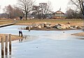
- Kirchhorster lake . The 4.8 ha large and up to 7.5 m deep lake was created during the expansion of the BAB 7 at the end of the 1950s through sand extraction. The inauguration was on June 17, 1969. There is a publicly accessible swimming area by the lake. The lake is surrounded by sunbathing and resting areas for bathing on around 2 hectares.
- Parksee Lohne . The body of water is a privately operated, 3.2 hectare bathing lake in a wooded area. There is a campsite with the usual gastronomic options and a mini golf course on the premises.
- Wietzepark . The park was completed in 2005 and is located in the Wietzeniederung on the municipal border with Langenhagen , with the river being the border. The east side of the park belongs to Isernhagen. The Wietzepark is a local recreation area with the water surface of the Hufeisensee (quarry pond) and has a separate bathing area.
- Isernhagenhof - cultural center in the Farster peasantry (F. B.). The music school, art school and meeting place are located here next to the event location of the Isernhagenhof Kulturverein e. V. It is a former farm that has largely been preserved in its original state. In a former barn, cultural events, such as music concerts, take place regularly. The premises can also be rented for other events such as training courses and concerts.
- Old Riethof. It is an agricultural estate that has been owned by the Redeken family since the 15th century. At times it was used by the royal equestrian regiment as a forge and stable. At the beginning of the 19th century, the farm came back into rural use, from 1842 the owners changed several times. In 2001 there was a restoration of the listed main building from 1561 and a replica of the coach house . Today the building is used as the company headquarters.
- Isernhagen center. It represents the geographical center point between the seven Isernhagen districts. It is a crossroads in the Feldmark, at which a memorial stone was unveiled during a community festival on June 29, 2014 by Mayor Arpad Bogya and representatives of the Isernhagen community foundation . The community festival took place on the occasion of the 40th anniversary of the Isernhagen community in its current form.

Fachhallenhaus of the Wöhler-Dusch-Hof

Kirchhorster See with bathing platform
Wietzepark

Memorial stone at the center of Isernhagen


.jpg)

Sports

- TSV Isernhagen from 1947 e. V.
- After the end of the Second World War , the British military government set up the Hohenhorster Beginners sports club in 1946 , which from 1947 took the name of today's TSV Isernhagen von 1947 e. V. wears. At first only football was played, but over the years other branches such as gymnastics, tennis and sailing were added. For several years there has been a cooperation with the Isernhagener Volkslauf. The club's sports grounds with tennis courts and club restaurant are located in the Hohenhorster Bauerschaft (HB) district.
- TuS Altwarmbüchen from 1954 e. V.
- The TuS Altwarmbüchen sports club, founded in 1954, is located on the site near Lake Altwarmbüchener See, but also has access to the Bernhard-Rehkopf-Straße and Helleweg sports halls and the athletics facility on Helleweg. Divisions include football, handball, tennis, athletics, gymnastics, dance and table tennis.
- FC Neuwarmbüchen e. V.
- The Neuwarmbüchen football club was launched on September 1, 1946. Today he offers a wide range of sports, including soccer, athletics, tennis, dancing, martial arts, cheerleaders. In 2004 a beach volleyball facility was set up.
- WSV Altwarmbüchen e. V.
- The water sports club Altwarmbüchen e. V. was founded in 1973. He runs a sailing division and since 1983 a rowing division. The WSV Altwarmbüchen is the second largest sports club in the municipality of Isernhagen in terms of number of members.
- Steller sports club Kirchhorst from 1932 e. V.
- The SSV Kirchhorst, which is idyllically and close to nature in the Kirchhorst district, offers seven different types of sport.
Regular events
- May: Gourmet evening in the A2 Center for the benefit of the Isernhagen Community Foundation
- June: Isernhagener Hop Festival at the Marienkirche
- June: Tenth festival in the Kirchhorst district (only in uneven years)
- August: Altwarmbüchen moor festival
- August: Shooting Festival
- November: Hubertus hunt with pack
- December: Christmas market around the Marienkirche
Economy and Transport
Companies
In the district of Hohenhorster Bauerschaft have their headquarters or larger branches:
- Heinz von Heiden solid houses ( solid house construction)
- Saaten-Union GmbH
- Branches of u. a .: Agravis Raiffeisen , Backring Nord, Hölling-DMA, Honold Logistik Gruppe , Hörmann
The following companies are based in Isernhagen in other districts:
- BREE Collection GmbH & Co. KG (bags, accessories)
- Clinotest Rudolf Hoppe GmbH (workwear and contract textiles)
- Street One GmbH (fashion)
- Headquarters of Toyota Material Handling Deutschland GmbH (forklifts, pallet trucks)
There are plenty of shops in the districts of Altwarmbüchen, Kirchhorst and Hohenhorster Bauerschaft.
traffic
Isernhagen is close to the intersection of three motorways:
- The BAB 2 from Berlin via Braunschweig , Hanover , Bielefeld to Dortmund
- The BAB 7 from Hamburg via Hanover , Kassel to Würzburg
- The BAB 37 from Hildesheim via Hanover to Celle
The Hanover / Kirchhorst motorway junction (A 7 / A 37) is partly on the territory of the municipality.
Isernhagen station in the Hohenhorster Bauerschaft district is on the Hanover – Celle railway line and is served hourly by Metronom Eisenbahngesellschaft trains that run between Hamburg and Hanover (RE 3) or Uelzen and Göttingen (RE 2). The route from Langenhagen an der Heidebahn to Celle, also known as the "Hasenbahn", which began in 1913 , was only opened on May 15, 1938. Since then, it has been possible to run the trains from Hamburg to southern Germany without going through Lehrte and head-to-head in Hanover. Since November 2, 1964, the line has been open to two tracks.
Line 3 of the Hanover city railway connects the Altwarmbüchen district with Hanover. Seven bus routes from Greater Hanover (GVH) open up Isernhagen and connect the town with neighboring communities.
Hannover-Langenhagen Airport is located in neighboring Langenhagen . Various citizens' initiatives from the affected municipalities, which have come together in the working group "Better without night flights to Hanover Airport" (BON-HA), are opposing the associated noise pollution, especially from night flights.
Personalities
Sons and daughters of the church
- Wilhelm Dusch (1863–1947), politician ( DVP ), MdR
- Gustav Völker (1889–1974), heraldist
- Hans Kramer (1948–2013), national handball player
- Nessi Tausendschön (bourgeois Annette Maria Marx ; * 1963), Diseuse
- Robert Dill (* 1982), basketball player
- Caroline Noeding (* 1991), reigning Miss Germany
People connected to the community
- Gerhard Hoyermann (1835–1911) Gut Lohne, inventor of fertilizer Thomasmehl, Prussian Parliament 1883–1908
- Heinz Koberg (1914–2013), editor, photo chronicler, author
- Wilfried Ziegemeier (1926–2013), architect in Isernhagen
- Peter Mim (* 1952), pantomime
- Oliver Pocher (* 1978), comedian and entertainer (attended secondary school in Isernhagen)
- Anke Kühn (* 1981), former national hockey player (Olympic champion 2004)
- Bastian Schulz (* 1985), soccer player ( 1. FC Kaiserslautern )
literature
- Kurt Griemsmann: Isernhagen in the county of Burgwedel. Ed .: Municipality of Isernhagen NB, self-published 1973.
- Claudia Kempf-Oldenburg, Jes Tüxen: Isernhagen Chronicle Volume 1. Ed .: Community Isernhagen, 1990.
- Claudia Kempf-Oldenburg, Jes Tüxen: Isernhagen Chronicle Volume 2. Ed .: Community Isernhagen, 1992.
- Heinz Koberg : Our Isernhagen. Ed .: Isernhagen municipality, March 1984.
Web links
- Website of the municipality of Isernhagen
- Portal founded by citizens around and for Isernhagen (IsernhagenPortal)
Individual evidence
- ↑ State Office for Statistics Lower Saxony, LSN-Online regional database, Table 12411: Update of the population, as of December 31, 2019 ( help ).
- ↑ a b c d Claudia Kempf-Oldenburg, Jes Tüxen: Isernhagen Chronicle. In: ZVAB website. Vol. 1, 1990.
- ^ Karl Friedrich Leonhardt : The oldest citizen book of the city of Hanover and simultaneous sources. (= Sources and representations on the population of the city of Hanover, on behalf of the Magistrate of the capital Hanover, published by the Association for City of Hanover History and Population, Vol. 1), Leipzig 1933, p. 198. See Uwe Ohainski, Jürgen Udolph: Die Ortnames of the district and the city of Hanover. Bielefeld 1998, pp. 212, 241, 339.
- ^ A b Claudia Kempf-Oldenburg, Jes Tüxen: Isernhagen-Chronik. In: ZVAB website. Vol. 2, 1992.
- ↑ History of the St. Marien Church. In: Website of the St. Marien Church. Retrieved September 28, 2017.
- ^ Parish archives of St. Marien, Isernhagen K. B.
- ^ Matthias Blazek, Wolfgang Evers: Construction of the Reichsbahn line Celle-Langenhagen.
- ^ Federal Statistical Office (ed.): Historical municipality directory for the Federal Republic of Germany. Name, border and key number changes in municipalities, counties and administrative districts from May 27, 1970 to December 31, 1982 . W. Kohlhammer, Stuttgart / Mainz 1983, ISBN 3-17-003263-1 , p. 222 .
- ^ Federal Statistical Office (ed.): Historical municipality directory for the Federal Republic of Germany. Name, border and key number changes in municipalities, counties and administrative districts from May 27, 1970 to December 31, 1982 . W. Kohlhammer, Stuttgart / Mainz 1983, ISBN 3-17-003263-1 , p. 197 .
- ^ Matthias Blazek: From the Landdrostey to the district government - The history of the district government of Hanover as reflected in the administrative reforms . Ibidem-Verlag, Stuttgart 2004, ISBN 3-89821-357-9 .
- ^ Election results in Isernhagen. In: www.wahlen-regionhannover.de. Retrieved September 28, 2017.
- ↑ a b City Council of Isernhagen. In: Website of the community Isernhagen. Retrieved September 28, 2017.
- ↑ a b Shivered briefly, but Bogya wins again. In: Website Hannoversche Allgemeine Zeitung. May 25, 2014. Retrieved September 28, 2017.
- ↑ CDU honors political heavyweights. In: Website Hannoversche Allgemeine Zeitung. November 12, 2015, accessed September 28, 2017.
- ↑ Designs of coats of arms by Walter Pietschmann. In: Wikimedia Commons. Retrieved July 25, 2017.
- ↑ a b c Hanover district (ed.): Wappenbuch Landkreis Hannover . Self-published, Hanover 1985, p. 194-195 .
- ↑ Information about the popular local festival of clubs and associations in Altwarmbüchen. - Moorfest Altwarmbüchen - more fest. In: moorfest.jimdo.com. Retrieved January 12, 2017 .
- ^ Matthias Blazek, Wolfgang Evers: Construction of the Reichsbahn line Celle-Langenhagen . In: Cellesche Zeitung (Sachsenspiegel) , No. 21 and 22, May 29 and June 5, 1999.
- ↑ "Better without a night flight to Hannover Airport" (BON-HA). Retrieved December 15, 2018.
- ↑ Frank Walter: Night aircraft noise - opponents distribute their flyers. In: Website Hannoversche Allgemeine Zeitung. November 20, 2018, accessed December 15, 2018 .
Barsinghausen | Burgdorf | Burgwedel | Garbsen | Gehrden | Hanover | Hemmingen | Isernhagen | Laatzen | Langenhagen | Taught | Neustadt am Rübenberge | Pattensen | Ronnenberg | Seelze | Sighted | Jump | Uetze | Wedemark | Wennigsen (Deister) | Wunstorf
Altwarmbüchen |
Farster Farmers (FB) |
Hohenhorster peasantry (HB) |
Kircher farmers (KB) |
Kirchhorst |
Neuwarmbüchen |
Niedernhägen farmers (NB)