Wietze (Aller)
| Wietze | ||
|
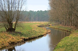
Wietze after 20 km between Mellendorf and Fuhrberg |
||
| Data | ||
| Water code | EN : 4872 | |
| location | Lower Saxony , Germany | |
| River system | Weser | |
| Drain over | Aller → Weser → North Sea | |
| Start from | Confluence of Flöth and Edder, northeast of Altwarmbüchen 52 ° 26 ′ 47 ″ N , 9 ° 51 ′ 59 ″ E |
|
| Source height |
56 m above sea level NHN Flöth: 60 m above sea level NHN , Edder: 59 m above sea level NHN |
|
| muzzle | northwest of the town of Wietze in the Aller coordinates: 52 ° 39 ′ 54 " N , 9 ° 48 ′ 22" E 52 ° 39 ′ 54 " N , 9 ° 48 ′ 22" E |
|
| Mouth height | 28 m above sea level NHN | |
| Height difference | 28 m | |
| Bottom slope | 0.84 ‰ | |
| length | 33.3 km | |
| Catchment area | 515 km² | |
| Discharge at the Meitze A Eo gauge : 242 km² Location: 16.3 km above the mouth |
NNQ (08/05/2001) MNQ 1967/2014 MQ 1967/2014 Mq 1967/2014 MHQ 1967/2014 HHQ (03/13/1981) |
105 l / s 439 l / s 1.58 m³ / s 6.5 l / (s km²) 8.44 m³ / s 18.8 m³ / s |
| Left tributaries | Laher Graben, Johannisgraben (Mühlengraben), | |
| Right tributaries | Wiesenbach, Hengstbeeke, Wulbeck, Rixförder Graben, Fuhrengraben | |
| Big cities | Hanover | |
| Medium-sized cities | Langenhagen | |
| Communities | Wedemark , Wietzesiedlung, Wieckenberg , Wietze-Steinförde, Wietze | |
The Wietze is an approximately 30 km long left tributary of the Aller in Lower Saxony , Germany .
geography

The river is created by the confluence of the Edder and Flöth northeast of Hanover near Altwarmbüchen . From there the water flows a few kilometers to the west through southern Isernhagen to Langenhagen and from then on only in a northerly direction to the town of Wietze , only to flow into the Aller shortly after coming from the south .
In the second half of its largely straightened river course, the Wietze runs through an extensive valley with the predominantly boggy Wietzenbruch , an area of around 400 square kilometers of wooded and broken forest . On its eastern edge lies the Cellesche district Wietzenbruch . A large part of the drinking water in the city of Hanover is pumped into the Wietze valley.
The Wietze continues the direction of flow of the Leine , which swings west near Hanover, to the north. The name of the river is derived from wizene (mountain elm river ).
history
Fishing was still practiced in the Wietze in the 19th century. Around Isernhagen, the Wietzeauen were drained from the 19th century. This enabled flooding in the populated surrounding area to be regulated.
ecology
Since 2012, the city of Hanover has been redesigning the Wietze, which runs in its area, with the aim of creating a water system that complies with the EU Water Framework Directive . In the course of this, the city is creating retention areas typical for floodplains. It redesigns the Wietze stream bed in some areas, creating an arched course and preserving the previous parts as oxbow lakes. Flatter banks with a transition to adjacent fallow areas are created. Gravel and dead wood are built into the bottom of the stream. It is thereby upgraded in its structure. New pond meadows and a floodplain landscape are to be created in some areas.
Web links
- Wietzenbruch landscape profile with map from the Federal Agency for Nature Conservation
- Description at hannover.de
- Water quality map of the Fuhse / Wietze-Nordwest sub-catchment area of the NLWKN
- NLWK water quality report Fuhse / Wietze 2003 (PDF file; 6.3 MB)
Individual evidence
- ↑ Water body data sheet 16001 Wietze (November 2012; PDF; 113 kB), accessed on October 28, 2013.
- ^ German Hydrological Yearbook Weser-Ems 2014. Lower Saxony State Agency for Water Management, Coastal Protection and Nature Conservation, p. 186, accessed on October 4, 2017 (PDF, German, 8805 kB).
- ↑ Die Wietze on the website of the Isernhagen-Süd Citizens' Association, accessed on June 16, 2018.
- ↑ Hannoversche Allgemeine Zeitung of November 10, 2016, edition of the City of Hanover, Stadt-Anzeiger Ost, p. 4.
