
Wietze
| coat of arms | Germany map | |
|---|---|---|

|
Coordinates: 52 ° 39 ' N , 9 ° 50' E |
|
| Basic data | ||
| State : | Lower Saxony | |
| County : | Celle | |
| Height : | 32 m above sea level NHN | |
| Area : | 62.95 km 2 | |
| Residents: | 8360 (Dec. 31, 2019) | |
| Population density : | 133 inhabitants per km 2 | |
| Postal code : | 29323 | |
| Area code : | 05146 | |
| License plate : | CE | |
| Community key : | 03 3 51 023 | |
| LOCODE : | DE WZZ | |
| Community structure: | 4 localities | |
| Address of the municipal administration: |
Neue Mitte 1–3 29323 Wietze |
|
| Website : | ||
| Mayor : | Wolfgang Klussmann | |
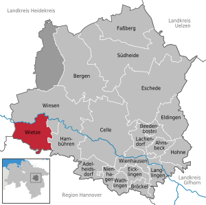
| Location of the municipality of Wietze in the district of Celle | ||
  |
||

Wietze is a municipality with over 8,000 inhabitants in the district of Celle in the southernmost foothills of the Lüneburg Heath in Lower Saxony .
geography
The community is located about 20 km west of Celle , 40 km north of Hanover and 15 km east of Schwarmstedt . The districts of Hornbostel, Jeversen and Wieckenberg belong to the municipality of Wietze .
The river Wietze flows shortly before its confluence with the All through the village Wietze.
history
Through the settlement of farms between the river “wizene” and today's federal road B214, today's districts of Wietze and Steinförde developed. The place "Steinförde" was mentioned about 50 years before the first written mention of "Wietze". The name is said to Wietze passage on court Stone ( = "Steinfuhrt" to return). On October 17, 1928, Wietze and Steinförde were merged under the name "Wietze". Due to a regional reform on January 1, 1973, today's districts Wieckenberg, Jeversen and Hornbostel were added. There was a potash mine in Steinförde from 1912 to 1923 .
Wietze and petroleum


In Wietze there was documentary evidence that heavy crude oil was extracted from above- ground tar hollows since 1652 . The tar trench could only be carried out in the dry summer months due to the high groundwater level in the Wietze lowlands. At the beginning of the 19th century there were several tar hollows in Wietze along the so-called Trift on the southern edge of the village. What came out of the earth was called Smeer or Satan's bacon and was used in a variety of ways: as wagon grease, wood preservative, sealing material in shipbuilding, covering damage to fruit trees and treating wounds of animals and people. In the 1830s, attempts were made to extract asphalt from the tar .
In the middle of the 19th century, the Royal Hanoverian government became aware of the “mineral oil sources” in Wietze while searching for raw materials. At the end of July 1858, under the direction of Georg Christian Konrad Hunäus, one of the first oil wells worldwide took place on the edge of the so-called Wallmann tarry hole, which has been occupied since 1652. The actual reason for the drilling was the search for lignite , as it was assumed that the raw materials crude oil and coal were socialized. However, the drilling had to be aborted unsuccessfully at a depth of 35.6 m, as it was not possible to overcome an Ice Age bed load in the subsoil. In the period that followed, oil was probably extracted from the well in larger quantities than before by the tar pit owner Wallmann. In contrast to the 1859 well in Titusville , Pennsylvania, which triggered a commercial “oil rush”, nothing comparable happened in Wietze at that time, presumably because the occurrence at this point was known for a long time.
It was not until 1899 that the oil fever broke out in Wietze, when the first drilling on the so-called Devil's Island north of the Wietze river (the tar hollows were all south of it), at a depth of now 140 m, pressed free-flowing oil to the surface of the earth. 2536 tons of crude oil were produced, in 1900 it was already over 27,000 tons. In 1905 32 competing companies were already active in Wietze. The oil was initially transported in wooden barrels on horse-drawn vehicles to Celle and Schwarmstedt and from there by train to the refineries in Hamburg and Bremen . In 1903 the railway line between Celle and Schwarmstedt, the Allertalbahn , was completed. The largest oil tanks in Europe at the time, each with a capacity of 11,000 m³, were built on the railway line in the immediate vicinity of the oldest tar hole. Since economic shipping was not possible on the Aller, the river from Celle to the mouth of the Lein was channeled from 1908. Four barrages with locks were built and the depth of the fairway was increased from 0.5 m to over 1.5 m. The locks were 165 m long and 10 m wide. The tankers, 48.5 m long and 7.2 m wide, could load 330 tons. Because of the many narrow loops of the Aller, no larger ships were possible. In Wietze, the Deutsche Vacuum Oil Company built a loading pier with two storage tanks of 4,000 m³ each. In 1909 around 21,000 tons of crude oil were transported by ship from Wietze to Bremen. The oil loading point in Wietze existed until the mid-1920s.
The oil boom changed the Heidedorf Wietze within a few years. The infrastructure was considerably improved (road expansion, "oil railway", expansion of the Aller , electrification), numerous hotels and shops were built and the number of residents increased significantly. A refinery was even built in Wietze in 1904, the capacity of which soon proved to be too low. The number of drilling operations increased so rapidly that most of the workers could not find permanent housing in the village; the proportion of commuters was 90 percent. From 1908 a workers' colony (Neu-Wietze) with a large number of identical houses was built in Steinförde, which was built by the Deutsche Mineralöl-Industrie AG, founded in 1906. From 1909 Wietze was supplied with electricity from the steam and later hydroelectric power station in Oldau (today part of Hambühren ), which was important for driving the drilling cranes and deep pumps.
A total of 52 companies were active in Wietze, 24 of which were absorbed by Deutsche Tiefbohr AG (later: Deutsche Erdöl AG = DEA). Wietze temporarily covered 80 percent of German domestic demand . The search for oil was intensified in the course of the First World War .
In 1934 the “Geographisches Anzeiger” stated: “The workforce at the Wietze plant is around 900 men, many of whom come to work from a wider area, mostly on wheels. Others live in an extensive settlement around Wietze. "
Until the final shutdown of all operations in 1963 for economic reasons, there had been 2028 wells in Wietze (around 1600 successful ones) and a mine with a route network of over 95 km in length at depths between 222 and 246 m. In the mine, miners (also known as Ölmuckel in the region ) extracted around one million tons of crude oil from oil sands in the form of seepage oil (749,800 t) and washing oil (214,000 t) between 1918 and 1964 . The degree of oil removal in the oil shaft was almost 100% (only approx. 16% were achieved through drilling).
Today, various institutions remind of the 100 year industrial history in Wietze. These are the approximately 55 m high "Ölberg" - a former spoil dump -, a storage area, the RWE DEA central laboratory set up in 1958 and above all the German Petroleum Museum , which is located on an almost two-hectare section of the old oil field and has several original ones and still functional conveyor facilities from before 1930.


religion
The Evangelical Lutheran residents of Wietze were originally parish in Winsen / Aller. In 1907 a permanent parish collaboration was established there with its seat in Wietze, and in 1910 a third parish office was terminated. In 1921 the parishes of Wietze, Steinförde, Hornbostel, Jeversen and Wieckenberg were spun off from the Winsen parish and merged into the Wietze-Steinförde parish. The third pastor's position was transferred to the new parish. In 1962 the Evangelical Lutheran Church of St. Michael was built. In winter the service takes place in the neighboring cemetery chapel. The parish also includes the cemetery and the Stechinelli chapel in the Wieckenberg district (see sights ). The parish belongs to the parish of Celle in the Lüneburg district .
The Catholic Church Maria Hilfe der Christians was built in 1910, today it belongs to the parish of the Holy Guardian Angels in Hambühren .
The New Apostolic Church , whose congregation has existed in Wietze since 1928, belongs to the Hannover-Nordost church district.
politics
Municipal council
The council of the municipality of Wietze is composed of 22 members and the directly elected full-time mayor .
| CDU | SPD | FDP | Green | WGW | WuW | Vondracek | total | |
| 2001 | 10 | 8th | 1 | 0 | 1 | 0 | 0 | 20 seats |
| 2006 | 9 | 8th | 1 | 1 | 0 | 0 | 1 | 20 seats |
| 2011 | 10 (45.5%) | 7 (29.7%) | 0 | 2 (10.6%) | 0 | 2 (6.8%) | 1 (4.8%) | 22 seats |
Local elections in Lower Saxony 2011
mayor
Mayor is Wolfgang Klußmann (CDU).
Culture and sights
Buildings

The Stechinelli Chapel , built in 1692, is located in the Wieckenberg district. It has the outer shape of a farmhouse, but the inside has a well-preserved baroque interior. It was consecrated in 1699. It was built by Francesco Maria Capellini, known as Stechinelli (1640–1694), the court banker of the Celle Guelph Duke Georg Wilhelm . Stechinelli acquired the noble estate in Wieckenberg as Landdrost in 1677. In 1678 he was appointed general hereditary postmaster of the three Guelph principalities of Lüneburg , Calenberg and Wolfenbüttel .
The Contidrom is located in Jeversen , a test site run by Continental AG for testing vehicle tires.
Architectural monuments
Green spaces and recreation
To the north of Wietze is the “ Hornbosteler Hutweide ” nature reserve , a 176 hectare area that was placed under protection in 2004. Here you can still find well-preserved remains of the typical hat landscape . Heck cattle , and since 2009 also Przewalski horses , graze this part of the Allerniederung.
Regular events
Various events take place throughout the year. Worth mentioning are the annual rifle festival, the courtyard festival of the volunteer fire brigade , the potato market, the trade show, the ancient hustle and bustle at the historic forest smithy in Wieckenberg and several concerts.
Economy and Infrastructure
Companies
In Wietze, the Wietze poultry slaughterhouse was built in 2010 at a distance of 1.5 km from the center of the village . The company Celler Land Frischgeflügel operates the facility, which (as of 2019) offers 800 jobs.
Public facilities
The municipality of Wietze has three day-care centers for children and a primary school. There is a police station.
A support association was founded so that the community's outdoor pool does not have to be closed. Events such as concerts or 24-hour swimming take place here at irregular intervals.
The four volunteer fire brigades include around 150 volunteer helpers who provide fire protection and general help. These volunteer fire brigades have 13 fire engines . In all districts there is a youth fire brigade with a total of almost 100 members.
traffic
Wietze is on the B 214 from Celle via Schwarmstedt to Nienburg , which intersects with the BAB 7 about 10 km west of Wietze .
The railway line ( Allertalbahn ) leading from Celle via Wietze and Schwarmstedt in the direction of Verden - Bremen was opened on October 1, 1903. Passenger traffic ended in Wietze on September 25, 1966, goods traffic on January 31, 1985; then the tracks were dismantled .
literature
- Drilling in the Wietze area. In: Petroleum. 1, Vienna 1905/06, pp. 63, 121 f.
- Friedrich Behme: The oil area of Wietze near Celle. In :: Pump and well construction, drilling technology. 13, Berlin 1917, p. 126.
- Matthias Blazek: Steinförde during the French period. In: The Electorate of Hanover and the years of foreign rule 1803–1813. ibidem-Verlag, Stuttgart 2007, ISBN 978-3-89821-777-4 , p. 87 ff.
- Paul Borstelmann: Contributions to the history of the municipality of Wietze with Steinförde, Hornbostel, Jeversen, Wieckenberg . Wietze 1978.
- C. Engelke: tar pits and drilling for petroleum near Wietze and Steinförde in Lüneburg. In: Annual notebooks of the Natural Science Association for the Principality of Lüneburg. 7, Lüneburg 1874, p. 50 ff.
- Otto Lang: Via oil and salt to Wietze-Steinförde. Essen, Glückauf 1897, p. 627.
- Erich Seidl: Description of the salt deposits Steinförde and Ovelgönne . - Erl. Z. Blatt Winsen (Aller), M. Bl. 1744 (old), Berlin 1911, p. 34.
- Jakob Stoller : The Wietze-Steinförde oil field . In Harbort, E., Seidl, E., Stoller, J .: Explanations on sheet Winsen ad Aller . Delivery 187 of the geological map of Prussia, Berlin 1916, p. 44.
- Oil in Wietze. Illustrated book. Geiger-Verlag, Horb am Neckar 1994, ISBN 3-89264-910-3 .
Web links
Individual evidence
- ↑ State Office for Statistics Lower Saxony, LSN-Online regional database, Table 12411: Update of the population, as of December 31, 2019 ( help ).
- ^ Districts on the Wietze website .
- ^ Federal Statistical Office (ed.): Historical municipality directory for the Federal Republic of Germany. Name, border and key number changes in municipalities, counties and administrative districts from May 27, 1970 to December 31, 1982 . W. Kohlhammer, Stuttgart / Mainz 1983, ISBN 3-17-003263-1 , p. 224 .
- ^ Stephan A. Lütgert: New findings on the origins of the petroleum industry in Northern Germany . In: petroleum, natural gas, coal. Issue 1, 2017, pp. 2–5.
- ↑ Walter Rühl (head of the research laboratory for crude oil production in Wietze): Lecture 125 years of crude oil in Wietze. (PDF; 117 kB) (No longer available online.) September 17, 1983, formerly in the original ; accessed on October 22, 2019 . ( Page no longer available , search in web archives )
- ^ Titusville, Pennsylvania, 1896. World Digital Library , 1896, accessed July 17, 2013 .
- ↑ History of oil production and oil path .
- ↑ Hermann Haack , Justus Perthes (Ed.): Geographischer Anzeiger - sheets for geographic teaching. Volume 35, Gotha 1934, p. 351.
- ^ Salfeld: Wietze-Steinförde. In: Philipp Meyer: The pastors of the regional churches of Hanover and Schaumburg-Lippes since the Reformation . Volume 2, Göttingen 1942, p. 508.
- ↑ Preliminary results of the district and municipal elections as a PDF document 2.90 MB ( Memento of the original from January 11, 2016 in the Internet Archive ) Info: The archive link was inserted automatically and has not yet been checked. Please check the original and archive link according to the instructions and then remove this notice.
- ↑ Helmut Rüggeberg: Stechinelli died 300 years ago - the poor Italian became the richest man in the principality. In: Sachsenspiegel. 48, Cellesche Zeitung of November 26, 1994.
- ↑ NLWKN: NSG Hornbosteler Hutweide .
- ↑ https://www.landgefluegel.de/portfolio-items/celler-land-frischgefluegel-haehnchenververarbeitungbetrieb/ Celler Land Frischgeflügel, accessed on November 28, 2019
- ↑ Wietze swimming pool
Adelheidsdorf | Ahnsbeck | Beedenbostel | Mountains | Crumble | Celle | Eicklingen | Eldingen | Eschede | Fassberg | Hambühren | Scorn | Lachendorf | Langlingen | Nienhagen | Südheide | Wathlingen | Wienhausen | Wietze | Winsen (Aller)