Bundesstrasse 214
| Bundesstrasse 214 in Germany | ||||||||||||||||||||||||||||||||||||||||||||||||||||||||||||||||||||||||||||||||||||||||||||||||||||

|
||||||||||||||||||||||||||||||||||||||||||||||||||||||||||||||||||||||||||||||||||||||||||||||||||||
| map | ||||||||||||||||||||||||||||||||||||||||||||||||||||||||||||||||||||||||||||||||||||||||||||||||||||
| Basic data | ||||||||||||||||||||||||||||||||||||||||||||||||||||||||||||||||||||||||||||||||||||||||||||||||||||
| Operator: |
|
|||||||||||||||||||||||||||||||||||||||||||||||||||||||||||||||||||||||||||||||||||||||||||||||||||
| Start of the street: |
Lingen (Ems) ( 52 ° 31 ′ N , 7 ° 21 ′ E ) |
|||||||||||||||||||||||||||||||||||||||||||||||||||||||||||||||||||||||||||||||||||||||||||||||||||
| End of street: |
Braunschweig ( 52 ° 18 ′ N , 10 ° 29 ′ E ) |
|||||||||||||||||||||||||||||||||||||||||||||||||||||||||||||||||||||||||||||||||||||||||||||||||||
| Overall length: | 252 km | |||||||||||||||||||||||||||||||||||||||||||||||||||||||||||||||||||||||||||||||||||||||||||||||||||
|
State : |
||||||||||||||||||||||||||||||||||||||||||||||||||||||||||||||||||||||||||||||||||||||||||||||||||||
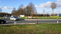
| Diepholz-Nordwest roundabout. In the front left it goes to Lingen, in the back right to Nienburg; At the back left, the B 69 branches off to Vechta and Oldenburg . | ||||||||||||||||||||||||||||||||||||||||||||||||||||||||||||||||||||||||||||||||||||||||||||||||||||
|
Course of the road
|
||||||||||||||||||||||||||||||||||||||||||||||||||||||||||||||||||||||||||||||||||||||||||||||||||||
The federal highway 214 (abbreviation: B 214 ) leads from Lingen to Braunschweig .
course
The federal road B 214 begins at the Lingener Höhe , the highest point in the Emsland , where it branches off from the federal roads B 70 and B 213 . First, it leads east to the north of the Osnabrück district , where it crosses the Ankumer Höhe in the Northern Teutoburg Forest-Wiehengebirge Nature Park . At the Holdorf junction, it crosses the A 1 motorway .
In the further course the B 214 touches the Dammer Mountains and leads north past the Dümmer through numerous moor areas . To the north-west of Diepholz , the bypass road partially divides the route with the B 51 .
In Nienburg , the federal highway 214 crosses the Weser on a section that runs jointly with the B 6 . To the east of the Leine , the B 214 runs parallel to the Aller through the southern foothills of the Lüneburg Heath . At the Schwarmstedt junction, it crosses the A 7 .
After Celle it changes its course to the southeast and continues west of the Oker . In Ohof near Meinersen it runs over the high-speed railway line Hanover – Berlin , where there was a level crossing until 1997. After the Wendeburg district of Neubrück, it crosses the A 2 (Braunschweig-Watenbüttel junction) and then the Mittelland Canal . It ends after crossing the Braunschweig district of Watenbüttel , where it merges into the A 392 .
Local authorities
- Lower Saxony
-
Emsland district
- Lingen (Ems) , Thuine , Freren , Andervenne
-
District of Osnabrück
- Fürstenau , Ankum , Bersenbrück , Gehrde , Badbergen
- District of Vechta
- District of Diepholz
-
District of Nienburg / Weser
- Wietzen , Marklohe , Nienburg / Weser , Steimbke , Rodewald
- Heidekreis district
-
District of Celle
- Wietze , Hambühren , Celle , Wienhausen , Eicklingen , Bröckel
- Hanover region
- Gifhorn district
- District of Peine
- Gifhorn district
- Braunschweig
-
Emsland district
Waters crossed
- Hase , in Bersenbrück
- Hunte , in Diepholz
- Wagenfelder Aue , in Barver
- Weser , in Nienburg
- Leine , in Schwarmstedt
- Wietze , in Wietze
- Fuhse , in Celle just before the confluence with the Aller
- Mittelland Canal , in Braunschweig north of Watenbüttel
history
origin
The B 214 from Braunschweig to Lingen is the result of a long-distance road project from the 19th century. The Hanoverian heartlands in central and eastern Lower Saxony were to be connected with the Emsland, which became Hanoverian in 1815. Between Freren and Ankum, the road largely follows the route of an old road that Ernst Dünzelmann calls Holländerweg . There is still a path near the B 214 with this name in Andervenne . The road built in the 19th century also opened up the south of the Grand Duchy of Oldenburg for road traffic in an east-west direction. In the section between Diepholz and Steinfeld, the B 214 breaks through the centuries-old barrier of the Great Moor , which had been largely circumvented by old roads, as well as the other moors of the Diepholz Moorniederung , through which the federal road runs, to create a direct connection between the (former) To create district towns of Nienburg, Sulingen , Diepholz and Bersenbrück .
At the end of the 18th century, the idea of building a road between Braunschweig and Celle, the Celler Strasse , was fiercely opposed. Wilhelm Bettinghaus, Pastor of Wienhausen , was involved in the construction of the fortified Art Road ( Chaussee ) between Braunschweig and Celle:
- The road from Celle to Bröckel was laid out in the years 1790–1793 by Inspector Rehren. The original intention was to lead them from Weggenbruche via Wathlingen to Uetze. But the residents of the above-mentioned towns protested because they feared they would be too much of a nuisance by foreign warring peoples if access to their villages by a new country road were made so easy for them. The continuation of the road from Bröckel to Braunschweig took place in the years 1821–1823. The dam from Eicklingen to Wathlingen was built in 1808.
The westernmost section of the line between Lingen, Fürstenau and Bersenbrück was opened to traffic on July 1, 1856. A regular stagecoach ran on this road from the opening day until the opening of the Rheine – Quakenbrück railway line on July 1, 1879. From 1925 a bus line ran on the Freren – Lingen section .
Previous routes and names
Between 1934 and 1949 the line was called Reichsstraße 214 (R 214).
The B 214 used to run within Braunschweig past its current end at Amalienplatz, across Celler Strasse, the western Okerarm and the Radeklint to the city center.
Since the era of the Reichsstrasse, many of the former through-roads of the B 214 have been replaced by bypass roads, most recently the Diepholz through-road in 2008 . Since the B 214 and the B 6 crossed the Weser near Nienburg as a high road, there is no longer any risk of being blocked in the event of flooding.
Replacements
A section between Braunschweig-Watenbüttel and the so-called northern ring area in Braunschweig around the formerly independent village of Ölper was replaced in the 1980s by the approximately four-kilometer-long federal motorway 392 (Braunschweiger Nordtangente), which then leads further east to the Hamburger Straße exit .
The relatively short A 392 even contains a motorway junction, namely the Ölper junction with the federal motorway 391 .
The B 214 through Thuine and Freren was replaced by a bypass road in 2006. The original plans for this bypass go back to 1982. In the 1950s there were already plans to run the B 214 north of Thuine and Freren directly from Baccum to Andervenne.
Abandoned plans
The stretch from Nienburg to the intersection with federal highway 3 near Celle was originally intended to be expanded as a section of the abandoned federal highway 32 .
Future plans / construction projects
A north bypass is planned for the Bersenbrück area, this should lead from the B 68 Bersenbrück / Nord exit to Gehrde and then reconnect with the current course of the road. The city center of Bersenbrück is to be completely freed from through traffic after the relocation of the B 68. It is not yet clear when this project will be implemented.
tourism
Tourist routes
The German Half-timbered Road runs along the B 214 between Celle and Braunschweig. The Megalithic Culture Road leads past remarkable stone graves in the municipalities of Thuine and Freren and in Ankum .
Attractions
- Convent of the Franciscan Sisters of St. Martyr Georg Thuine
- Fürstenau castle and historic old town
- Parish church of St. Nikolaus (" Artländer Dom ") in Ankum
- Wienhausen Monastery
Web links
Individual evidence
- ↑ Federal road directory with long-distance and short-distance destinations (PDF) Federal Highway Research Institute . August 2009. Retrieved April 4, 2017.
- ↑ Kreuzenspunkt on members.efn.org/~marwes
- ^ Ernst Dünzelmann: The Roman road network in Northern Germany . In: Yearbooks for Classical Philology. 20. Supplement band. Leipzig 1894, p. 135
- ^ Wilhelm Bettinghaus: Heimathskunde der Kirchengemeinde Wienhausen, III. Theil , Celle 1901, p. 9.


