
Essel
| coat of arms | Germany map | |
|---|---|---|

|
Coordinates: 52 ° 41 ′ N , 9 ° 39 ′ E |
|
| Basic data | ||
| State : | Lower Saxony | |
| County : | Heidekreis | |
| Joint municipality : | Schwarmstedt | |
| Height : | 27 m above sea level NHN | |
| Area : | 34.05 km 2 | |
| Residents: | 1168 (Dec. 31, 2019) | |
| Population density : | 34 inhabitants per km 2 | |
| Postal code : | 29690 | |
| Area code : | 05071 | |
| License plate : | HK | |
| Community key : | 03 3 58 007 | |
| Community structure: | 4 localities | |
| Association administration address: | Am Markt 1 29690 Schwarmstedt |
|
| Mayor : | Bernd Block ( CDU ) | |
| Location of the municipality of Essel in the Heidekreis district | ||
  |
||

Essel is a municipality in the Lower Saxony district of Heidekreis and is part of the Schwarmstedt municipality .
geography
The main town Essel is located on the southern bank of the Aller . Autobahn 7 runs through the municipality .
The municipality of Essel consists of four localities:
history
Essel was first mentioned in 1251 as a donkey . The three gentlemen from Hademstorf took over the supervision of the Esseler Allerübergang and the control of the Aller shipping . They sat on the Uhlenburg in the 14th century . The castle was in the Allern lowlands between Essel and Buchholz (Aller) and was destroyed in 1394 by the dukes of Braunschweig-Lüneburg . In 2001 there were celebrations for the 750th anniversary.
Another castle was located in the 13th century near the Engehausen district in the form of the Blankenburg , from which a noble manor later developed.
From 1450 Essel seat was a Amtsvogtei and belonged to the adjacent bailiwicks Fallingbostel , Winsen and Bissendorf to United Bailiwick Celle . The Grand Bailiff of Donop had the official building and a granary rebuilt in Essel around 1580. The building became the property of Vollmeier Georg Heinrich Engehausen in 1874 . The street by the former official building has been named "Am Amtshof".
In July 1968 the Esseler elementary school was closed after about 300 years. On September 25, 2002, the community took part in the competition " Our village should be more beautiful - our village has a future ".
On March 1, 1974, the community Engehausen was incorporated.

Typical townscape

Horse paddock in place
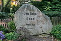
Memorial stone 750 years of Essel

Großköthnerhaus from 1662

Halbmeyerhaus from 1782

Courtyard with a half-timbered house from 1782


politics
Infrastructure
The federal road 214 and the A 7 motorway (with a junction at the Allertal service area) as well as the country road 190 run through the municipality . In neighboring Schwarmstedt there is a train station with a connection to Hanover or Hamburg-Harburg. The public transport is handled by buses.
The community has a kindergarten.
Architectural monuments
Individual evidence
- ↑ State Office for Statistics Lower Saxony, LSN-Online regional database, Table 12411: Update of the population, as of December 31, 2019 ( help ).
- ↑ Schwarmstedt - pictures. Retrieved June 26, 2020 .
- ^ Federal Statistical Office (ed.): Historical municipality directory for the Federal Republic of Germany. Name, border and key number changes in municipalities, counties and administrative districts from May 27, 1970 to December 31, 1982 . W. Kohlhammer GmbH, Stuttgart / Mainz 1983, ISBN 3-17-003263-1 , p. 225 .
- ↑ Schwarmstedt - Essel Kindergarten. Retrieved June 26, 2020 .
Web links
- Website of the joint community
- Website of the shooting club Essel (history of the place under "About us")
Ahlden (Aller) | Bad Fallingbostel | Bispingen | Böhme | Buchholz (Aller) | Eickeloh | Essel | Frankenfeld | Gilten | Grethem | Hademstorf | Häuslingen | Hodenhagen | Lindwedel | Munster | Neuenkirchen | Rethem (Aller) | Schneverdingen | Schwarmstedt | Soltau | Walsrode | Wietzendorf
Non- parish district in the district of Heidekreis
Osterheide