Grethem
| coat of arms | Germany map | |
|---|---|---|

|
Coordinates: 52 ° 43 ' N , 9 ° 35' E |
|
| Basic data | ||
| State : | Lower Saxony | |
| County : | Heidekreis | |
| Joint municipality : | Ahlden | |
| Height : | 24 m above sea level NHN | |
| Area : | 16.35 km 2 | |
| Residents: | 627 (Dec. 31, 2019) | |
| Population density : | 38 inhabitants per km 2 | |
| Postal code : | 29690 | |
| Area code : | 05164 | |
| License plate : | HK | |
| Community key : | 03 3 58 011 | |
| Address of the municipal administration: |
Neue Strasse 5 29690 Grethem |
|
| Website : | ||
| Mayor : | Udo Schönberg | |
| Location of the municipality of Grethem in the Heidekreis district | ||
Grethem is a municipality in the Heidekreis district in Lower Saxony . It belongs to the joint municipality of Ahlden , which has its administrative seat in the municipality of Hodenhagen .
geography
Grethem lies between Walsrode and Hanover west of the Aller . The district of Büchten belongs to Grethem.
history
About half a kilometer northeast of Grethem was Blankenhagen Castle from around 1200, of which two mounds of earth overgrown with bushes are still visible today. It was a Niederungsburg , the remains of which can be found on a field path near today's Gierseilfähre over the Aller .
On March 1, 1974, the municipality of Büchten was incorporated.
Mayor and City Council
The honorary mayor Udo Schönberg was elected on September 9, 2001.
Local election 2016 Distribution of seats:
- UWG: 5
- SPD: 2
- CDU: 2nd
coat of arms
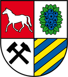
Blazon : "Shield quartered, field 1: in red a trotting silver horse, field 2: in silver blue berries on green leaves, field 3: in silver a black miner's teeth, field 4: in blue three diagonally left golden bars."
The coat of arms was designed in 2009 by the municipal heraldist Jörg Mantzsch .
Economy and Infrastructure
The federal highway 7 is east of the community. The next junction is in Buchholz (Aller) approx. 13 km away.
Architectural monuments
Individual evidence
- ↑ State Office for Statistics Lower Saxony, LSN-Online regional database, Table 12411: Update of the population, as of December 31, 2019 ( help ).
- ^ Federal Statistical Office (ed.): Historical municipality directory for the Federal Republic of Germany. Name, border and key number changes in municipalities, counties and administrative districts from May 27, 1970 to December 31, 1982 . W. Kohlhammer GmbH, Stuttgart / Mainz 1983, ISBN 3-17-003263-1 , p. 224 .
- ↑ https://www.ahlden.info/sg_ahlden/de/Wahlen/Wahl%20zum%20Rat%20der%20Gemeinde%20Grethem/


