
Osterheide
| coat of arms | Germany map | |
|---|---|---|

|
Coordinates: 52 ° 51 ' N , 9 ° 44' E |
|
| Basic data | ||
| State : | Lower Saxony | |
| County : | Heidekreis | |
| Height : | 62 m above sea level NHN | |
| Area : | 177.99 km 2 | |
| Residents: | 2789 (Dec. 31, 2019) | |
| Population density : | 16 inhabitants per km 2 | |
| Postcodes : | 29664 (Ostenholz) , 29683 (Oerbke, Wense) |
|
| Primaries : | 05162, 05163, 05167 | |
| License plate : | HK | |
| Community key : | 03 3 58 501 | |
| Territory administration address : |
Gillweg 7 29683 Oerbke |
|
| Website : | ||
| District Head : | Andreas Ege | |
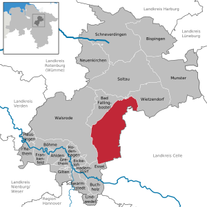
| Location of the community-free area Osterheide in the district of Heidekreis | ||
  |
||

The Osterheide is an inhabited, parish-free district in the Heidekreis district on the southern edge of the Lüneburg Heath in Lower Saxony . The area is located south and east of Bad Fallingbostel and about 20 km west of the Südheide Nature Park .
geography
The 178.53 km² area has 2789 inhabitants (as of December 31, 2019). The seat of the administration is the village of Oerbke ; furthermore the villages Ostenholz and Wense belong to the community-free district. The municipal administration of the NATO military training area (TrÜbPl) Bergen is carried out by the municipality-free district of Osterheide together with the municipality-free district of Lohheide which is adjacent to the east .
Neighboring municipalities of the area are, listed clockwise:
- Essel (south)
- Walsrode (west)
- Bad Fallingbostel (northwest / north)
- Wietzendorf (north / northeast)
- Lohheide ( municipality-free area , east)
- Wince
structure
The municipality-free district is divided into ten districts :
![]() Map with all coordinates: OSM | WikiMap
Map with all coordinates: OSM | WikiMap
| Gemar- Substandard no. |
District | Area (km²) |
Coordinates | Remarks | Postcode | prefix |
|---|---|---|---|---|---|---|
| 2342 | Becklinger wood | 52 ° 52 ' N , 009 ° 51' E | - | - | ||
| 2343 | Fuhrhop | 52 ° 56 ' N , 009 ° 49' E | - | - | ||
| 2344 | Wense | 52 ° 55 ' N , 009 ° 49' E | Village | 29683 | 05163 | |
| 2346 | Unteinzingen | 52 ° 53 ' N , 009 ° 47' E | - | - | ||
| 2347 | Obereinzingen | 52 ° 52 ' N , 009 ° 48' E | - | - | ||
| 2348 | Oerbke | 52 ° 51 ' N , 009 ° 44' E | Administrative headquarters | 29683 | 05162 | |
| 2349 | Hard | 52 ° 49 ' N , 009 ° 44' E | Ostholz village | 29664 | 05167 | |
| 2350 | Oberndorfmark | 52 ° 50 ' N , 009 ° 47' E | - | - | ||
| 3740 | Oberhode | 52 ° 46 ' N , 009 ° 47' E | - | - | ||
| 3869 | Krelingen | 52 ° 48 ' N , 009 ° 40' E | - | - | ||
| Osterheide | 177.99 | 52 ° 51 ' N , 009 ° 44' E |
The Lower Saxony housing directory as of November 1, 2006 shows the following 41 housing spaces and desolations for the ten municipalities:
|
|
Population numbers were last recorded in the 1964 housing directory on the census date June 6, 1961:
![]() Map with all coordinates: OSM | WikiMap
Map with all coordinates: OSM | WikiMap
| Living space | District | Population 1961-06-06 |
Coordinates |
|---|---|---|---|
| Böstlingen 1) | Hard | 136 | 52 ° 49 '42 .0 " N , 009 ° 42' 22.0" E |
| Blocksberg | Hard | 23 | ... |
| Driving wood | Hard | 158 | 52 ° 49 ′ 13.0 " N , 009 ° 41 ′ 41.0" E |
| Probes | Hard | 60 | ... |
| Singles 1) | Unteinzingen | 20th | ... |
| Charlottenthal | Unteinzingen | 21st | ... |
| Hormannshof | Unteinzingen | 16 | ... |
| Sheep farm | Unteinzingen | 11 | ... |
| Ettenbostel 1) | Hard | 117 | 52 ° 47 '34.0 " N , 009 ° 42' 21.0" E |
| Mengdorf | Hard | 39 | ... |
| Seyersbruch | Hard | 12 | ... |
| Upper testicle 1) | Oberhode | 149 | ... |
| Blocks | Oberhode? | 5 | ... |
| Dövenhof | Oberhode | 4th | ... |
| Eitze | Oberhode? | 23 | ... |
| Hambruch | Oberhode? | 19th | ... |
| Heidkamp | Oberhode? | 13 | ... |
| Hohenbrelingen | Oberhode | 21st | ... |
| Meyerhof | Oberhode | 9 | ... |
| Meyersbruch | Oberhode | 6th | ... |
| Bringing down | Oberhode | 15th | ... |
| East Settlement | Oberhode | 35 | ... |
| Schnierhof | Oberhode | 9 | ... |
| Örbke 1) | Örbke | 461 | 52 ° 51 '10.0 " N , 009 ° 43' 48.0" E |
| Fallingbostel, warehouse | Hard | 288 | ... |
| Ostenholz 1) | Hard | 387 | 52 ° 46 '31.6 " N , 009 ° 43' 20.2" E |
| Haymills | Oberhode | 19th | ... |
| In Katzhagen | Hard | 95 | ... |
| Ostenholzer Moor | Hard | 20th | 52 ° 43 '33.0 " N , 009 ° 42' 31.0" E |
| Sieken | Hard | 37 | ... |
| Söhnholz | Hard | 19th | ... |
| Sölterbruch | Hard | 6th | ... |
| Wense 1) | Wense | 96 | 52 ° 55 '11.0 " N , 009 ° 48' 59.0" E |
| Osterheide | 2349 | 52 ° 51 '00.0 " N , 009 ° 44' 00.0" E |
1) former municipalities
- Maps of the Osterheide area

Bergen military training area, municipal boundaries 1936/38

The Heidmark in 1935 and 2002

Places evacuated when the TrÜbPl-Bergen was set up (no names)

Land use in Obereinzingen and Untereinzingen in 1906. Dorfmark is to the northwest . In the south the road runs from Oerbke via Nordbostel and Hanglüss to Bleckmar .

Land use 1979. Settlements and courtyards that were within the square have become devastated . The forest areas have increased due to afforestation. Parts of the former arable land and meadows are preserved as grassland.


history
The current districts go back to the former communities of the Fallingbostel district in the Lüneburg administrative district of the Prussian province of Hanover .
1935 by the German Wehrmacht between Bergen and Fallingbostel the Bergen military training area created. To this end, a total of 24 communities were dissolved and their residents relocated. In 1938 the "Gutsgebiet Platz Bergen" area, which encompasses the military training area, was formed and assigned to the Fallingbostel district . In 1945 the manor district was divided into two independent areas, namely the manor districts Osterheide and Lohheide. Osterheide remained with the Fallingbostel district, while Lohheide was reintegrated into the Celle district. The Osterheide today includes the part of the 1958 "NATO shooting range Bergen-Hohne" located in the district of Heidekreis. On January 1, 2011, the Federal Agency for Real Estate Tasks (BImA) took over the community-free district.
Legal situation
According to Section 23, Paragraph 4, Clause 3 of the Lower Saxony Municipal Constitutional Act (NKomVG), the administration of unincorporated areas is regulated by an ordinance . According to this, the "execution of the public tasks of the own and the assigned sphere of activity is entrusted to the landowner", in the case of Lohheide and Osterheide thus to the federal government. The constitution of a parish-free district is different from that of a parish. Its organs are the district head and the residents' council elected by the residents . The district head is proposed by the landowner and then elected by the residents' council. The residents' rights of participation are limited to the choice of representation as well as the possibility of residents' question-and-answer time and residents' hearing during public meetings of the representation.
Cultural monuments and sights
The cultural monuments , sights and memorials in and near the Osterheide include:
- in Oerbke (in the west):
- Cemetery of the Nameless, a war cemetery where around 30,000 Soviet prisoners of war from World War II were buried in mass graves
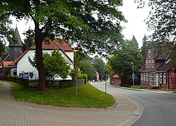
- in and near Ostenholz (in the southwest):
- Half-timbered church with a wooden tower from 1724
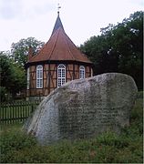
- Hoher Stein , a memorial stone for the evacuation of the communities in 1936 for the purpose of creating a military training area
- Seven stone houses , large stone graves from the Neolithic Age in the south of the military training area
- in Wense (in the northwest):
- Manor chapel as a magnificent church from 1558
Ostenholz

Ostenholz Church

Nameless cemetery in Oerbke
High stone in east wood


Architectural monuments
Wolf occurrence
A resident wolf pack was discovered in April 2017 . Five puppies were already registered in photo traps in August 2016. The male has been identified as coming from the Ueckermünder pack through genetic testing .
literature
- Hinrich Baumann: The Heidmark - Change of Landscape: The History of the Bergen Military Training Area. Oerbke 2005, ISBN 3-00-017185-1 .
Individual evidence
- ↑ State Office for Statistics Lower Saxony, LSN-Online regional database, Table 12411: Update of the population, as of December 31, 2019 ( help ).
- ↑ NLAHA Nds. 1241 Osterheide
- ↑ District register Lower Saxony xls-file
- ↑ Lower Saxony State Administration Office - Statistics: Official directory of the communities and places to live in Lower Saxony 1964, Hanover 1964, p. 58
- ^ Nessenius (1985): The cultural landscape change in the northern part of the Bergen military training area. 140 pages (unpublished)
- ^ Nessenius (1985): The cultural landscape change in the northern part of the Bergen military training area. 140 pages (unpublished)
- ↑ Municipal directory 1900
- ↑ Inscription of the "Hohen Stein": The memory of the Heidjer willing to make sacrifices from the former villages of Hörsten, Hoppenstedt, Hohne, Hasselhorst, Hohnerode, Manhorn, Lohe, Gudehausen, Ostenholz, Ettenbostel, Oberhode, Benhorn, Hartem, Fahrenholz, Böstlingen, Pröbsten, Kolk , Sudbostel, Nordbostel, Örbke, Obereinzingen, Untereinzingen, Achterberg , Wense.
- ↑ Report from Wildlife Management of the Lower Saxony State Hunters' Association , accessed on July 10, 2017
Web links
- NLAHA Nds. 1241 Osterheide: history
- Osterheide worth mentioning / seeing
- Former farms in the Heidmark and their ancestors
- www.osterheide.bundesimmobilien.de
- Buildings and apartments as well as living conditions of households in the municipality of Osterheide, gemfr. District on May 9, 2011, results of the 2011 census
Ahlden (Aller) | Bad Fallingbostel | Bispingen | Böhme | Buchholz (Aller) | Eickeloh | Essel | Frankenfeld | Gilten | Grethem | Hademstorf | Häuslingen | Hodenhagen | Lindwedel | Munster | Neuenkirchen | Rethem (Aller) | Schneverdingen | Schwarmstedt | Soltau | Walsrode | Wietzendorf
Non- parish district in the district of Heidekreis
Osterheide