Lütje Hörn
| Lütje Hörn | |
|---|---|
|
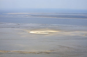
Lütje Hörn 2008 from the south, in the background Memmert and Juist |
|
| Waters | North Sea |
| Archipelago | East Frisian Islands |
| Geographical location | 53 ° 35 '26 " N , 6 ° 51' 50" E |
| surface | 6.5 ha |
| Residents | uninhabited |
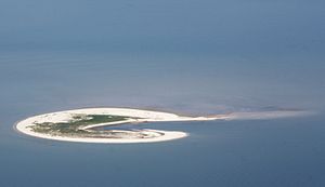
| Lütje Hörn 2010 | |
Lütje Hörn is an uninhabited East Frisian island about four kilometers east-southeast of the east end of Borkum in the East Frisian Randzel watt .
history
Lütje Hörn was first mentioned in 1576 in a sailing instruction as “Hooghe Hörn”. Since 1859 the island has been shown in the topographic maps on the wadden ridge south-east of Borkum.
geography
In contrast to all of the other East Frisian islands, Lütje Hörn has a shape that is stretched in a north-south direction. This is due to the island's location in the Osterems Current . Since it was first mentioned in a document, the position of the island has shifted around two kilometers further to the southeast. Between 1961 and 1999 alone, the island shifted a good 600 meters to the east and 150 meters to the south. This corresponds to a speed of 15 meters per year in the east and four meters per year in the south. In the years from 1999 to 2005, this eastward migration of the island continued for another 100 meters (16.7 meters per year). Due to erosion , Lütje Hörn has continuously lost its area. The size of the island was still relatively stable in the first half of the last century: in 1891 it was 61 hectares and in 1937 it was 54 hectares . In 1957 the flood-free area was 58 hectares, including an approximately one hectare core of dunes. The storm surge in February 1962 caused considerable land losses and dune erosion, while the winter storms of 1989/1990 caused further losses . In 1987 the area above the mean tidal high water (MThw) was only 23, a few years later only around 11 hectares. According to the Lower Saxony State Agency for Water Management, Coastal Protection and Nature Conservation (NLWKN), Lütje Hörn had a flood-free area of around 6.5 hectares in the summer of 2006.
Affiliation
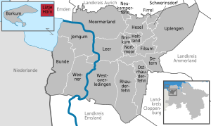
The uninhabited North Sea island does not belong to any municipality, but forms a municipality-free area in the district of Leer in Lower Saxony , although geographically it is upstream of the district of Aurich (similar to the island and city of Borkum). Lütje Hörn is the smallest municipality-free area in Germany in terms of area. The bird protection island belongs to Zone I of the Lower Saxony Wadden Sea National Park and may only be entered with the approval of the national park administration.
flora
On Lütje Hörn, dune development has so far only reached the stage of individual young secondary dunes in the north of the island. In 1989 they rose up to 1.5 meters above sea level, but fell sharply in 1990 due to severe storm surge effects. The main part of the island, however, was formed by wide primary dune fields in the south and the extensive "intermediate sand" between the two dune areas. In 1989 it still had elements of salt marshes that no longer existed in 1990. In the course of the constant shrinking of the area, the number of plant species has also decreased significantly. In 1988, in addition to dune grasses and salt marsh flora, there was also an elderberry bush as the largest plant on the island, but in 2006 there was not much to be seen of the vegetation. Many roots were spared, however, so that the plants can regenerate themselves in years with little storm tides. Nothing is left of the former secondary dune elements, only primary dune fields of around 3.5 hectares and small-area remains of salt marshes can be found.
fauna
The most common nesting on Lütje horn birds are silver and gull , eider and oystercatcher . In 1994 more than 450 breeding pairs of birds were counted on Lütje Hörn, in 2006 there were hardly more than 200 pairs. The cormorant , which has also been represented since 1994, is a special case . On the mainland, the bird usually breeds in trees, but on Lütje Hörn it has developed into a ground-breeder due to the lack of larger trees and due to the absence of humans and dogs. According to a study by the biologist Armin Rose from the University of Oldenburg in 1990, insects such as ruffflies (Staphylinidae), arachnids (Arachnida) and ground beetles (Carabidae) were found on the island .
various
In the book "The North Sea Coast, Part II, Elbe to IJsselmeer" by Karlheinz Neumann (1983), there is a report about a beacon on Lütje Hörn. This beacon was removed in 1984.
Individual evidence
- ↑ Ulrich Hellwig, Peter Körber: How fast does Scharhörn migrate? In: Association Jordsand (Hrsg.): SEEVÖGEL: Journal of the association Jordsand for the protection of the sea birds and the nature eV Band 39 , issue 3, June 2018, ISSN 0722-2947 , p. 8 .
- ^ Wattenrat.de: Islands and plateaus shaved off by storms
- ↑ natosti.uni-oldenburg.de: The flora and fauna of the East Frisian Islands: Lütje Hörn , viewed October 1, 2012.
- ↑ natosti.uni-oldenburg.de: The flora and fauna of the East Frisian Islands: fern and flowering plants , seen October 1, 2012.
- ↑ Armin Rose: The colonization of dune islands in early succession stages in the Lower Saxony Wadden Sea National Park by short-winged birds (Coleoptera: Staphylinidae) using the example of Lütje Hörn. (PDF; 311 kB)
- ↑ Beacons on Lütje-Hörn . Gerd Liedtke. Retrieved November 7, 2016.
Web links
|
The next island to the west: Borkum |
East Frisian Islands |
The next island to the east: Kachelotplate |


