
Minsener Oog
| Minsener Oog | ||
|---|---|---|
 |
||
| Waters | North Sea | |
| Archipelago | East Frisian Islands | |
| Geographical location | 53 ° 45 '47 " N , 8 ° 0' 48" E | |
|
||
| length | 4.5 km | |
| width | 1.5 km | |
| surface | 3.7 km² | |
| Highest elevation | 12 m above sea level NN | |
| Residents | uninhabited | |
 |
||

.png)


Minsener Oog , also known as Minser Oog , Minsener Olde Oog or Olde Oog , is an uninhabited East Frisian island that belongs to the municipality of Wangerooge in the district of Friesland and was fortified by the installation of groynes and thereby increased.
location
The island is just under two kilometers south-east of Wangerooge , from which it is separated by the Blaue Balje flow channel, and four kilometers north of the mainland . The closest places on the mainland are Minsen and Schillig . The landowner is the Wilhelmshaven Waterways and Shipping Office (WSA Wilhelmshaven).
Surname
The official name of the island is Minsener Oog and was determined in 2005 by the Standing Committee for Geographical Names (StAGN) with the publication of the Lower Saxony Coast map . The other names used, such as Minser Oog or Minsener Oldeoog, are only unofficial secondary names.
The name of the island is derived from the opposite mainland town of Minsen. There is a legend that Minsen used to be on the island of Minsener Oog. The local fishermen are said to have caught a mermaid with a fish underneath, who in revenge let the village sink into the waters. Based on this legend, there is the bronze sculpture of the Minsener Seewiefken in Minsen , which also represents the coat of arms of the municipality of Wangerland .
history
The island of Minsener Oog was created at the beginning of the 20th century from the sandbanks Minsener Oog and the Olde Oog and the sandbank Steenplate 200 to 300 meters south of it . From 1906 the Navy Construction Authority built Wilhelmshaven on Olde Oog groynes and dams to a silting of the fairway of the Jadestroms to prevent. This was intended to keep the shipping channel to Wilhelmshaven free from the sand drifting eastwards, especially for the fleet of the Imperial Navy . A small dune area was created on the original 7 km² Olde Oog sandbank , as well as on Minsener Oog. The sand was held back by the construction of long connecting groynes, and a fore dune was formed, which was soon adopted as a breeding ground for sea birds.
Originally it was planned to connect Wangerooge with the Minsener Olde Oog, so that Wangerooges land removal could come to an end. In the 1930s this project was temporarily resumed, but the events of the war prevented further work of this kind. After the Second World War , the British occupying forces tried to make Wilhelmshaven unusable as a naval port and to silt up the Jade estuary. As a first measure, a main dam on the Minsener Oog was blown up, but no further explosions were made.
Current condition
To secure the Jade fairway, a new, large-scale dune island was created in the 1970s through sand flushing. Over 10 million m³ of dredged material was dumped out of the Jade fairway in 1975 and 1978, and the southern part of the island continued to expand. It now has a dune landscape up to 12 meters high and is about 370 hectares in size. By planting beach grass, land runoff has now largely been curbed. The island is 4.5 kilometers long in a north-south direction, and up to 1.5 kilometers wide.
The WSA Wilhelmshaven in particular has been active on the Minsener Oog since the Second World War. There were always two groyne attendants working in shifts, who performed various maintenance tasks on the island. In addition to the radar tower built in 1976, there is a larger team area in the form of stilt houses for the WSA employees. Near the radar tower is a raised pier , the groyne C , at the end of which there is a landing stage. Due to the silting up, it can only be started at high water. There is a light railway on the island, it connected the south and north sides of the island. From the Radarum to the Molenspitze and the WSA's building yard, it is still functional today, but large parts of the track are no longer passable.
At the end of Groyne A in the north there is still a small flak tower made of concrete, which was built during World War II and served as a lighthouse until 1998. In 1998, the Wilhelmshaven Waterways and Shipping Office gave up its permanent presence on the island for cost reasons and only calls it up when required.
Since the automation of the beacon , vom Mellumrat e. Only lives in the summer months during the breeding season . V. appointed bird warden on the Minsener Oog, who also uses the barracks of the water and shipping office. The island is also considered one of the most important research areas for the Institute for Bird Research .

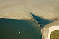
Aerial photo of the radar tower, in the background the mainland with JadeWeserPort , Wilhelmshaven power station (E.ON) and north-west oil pipeline (May 2012)

Aerial view of the radar tower and the crew area of the WSA employees

Aerial view of the track systems
Aerial view of the island


fauna
Lighthouse keepers who used to live on the island released rabbits as a living food reserve on the island. As an important breeding ground for sea birds, the island was placed under nature protection as early as 1959.
The breeding birds in 2004 were herring gull , herring gull , common gull , river , coastal , fire and little tern and Magpie , carrion crow and Barn Swallow . While the sandwich tern population was over 2,000 pairs, only a few pairs of the little tern were counted. Shelduck and stock pigeons have brooded in rabbit burrows.
tourism
In the summer months, mudflat hikes from Schillig on the mainland to the island are offered. For reasons of nature conservation, however, only a small part of the island may be entered. The whole island belongs to the quiet zone I of the Lower Saxony Wadden Sea National Park .

literature
- Tim Coldewey: Anthropogenic intervention in the maritime morphodynamics of an uninhabited North Sea island . Wilhelmshaven 2004
- Ernst Andreas Friedrich : Designed natural monuments of Lower Saxony , Landbuch-Verlag, Hanover 1982, ISBN 3-7842-0256-X
Web links
- Minsener Oog - Oldeoog island information
- Dipl.-Ing. Ralf Harms and BOR Rüdiger Oltmanns: 100 years of Minsener Oog electricity structures (PDF; 663 kB)
- Inselbahn.de - The material railway on Minsener Oog with photos, vehicle list and lots of information
- Minsener Oog Buhne C lighthouse at Leuchttürme.net
- Website of the Mellum Council
Individual evidence
- ↑ a b Hans Begerow: Minsener Oog is now an official name. In: NWZ Online . February 17, 2005, accessed October 15, 2019 .
- ↑ Digital panchromatic orthophotomosaic of the island Minseneroog from the flight in 2004. In: GDI-NI. Landesbetrieb Landesvergabe und Geobasisinformation Niedersachsen, 2004, accessed on November 12, 2019 .
- ↑ DGM5 availability district / city of Friesland. (PDF; 1.3 MB) Land surveying and geographic base information Lower Saxony, June 3, 2009, accessed on October 15, 2019 .
Borkum | Bant | Lütje Hörn | Brauerplate | Tile plate | Memmert | Juist | Norderney | Baltrum | Langeoog | Spiekeroog | Wangerooge | Minsener Oog | Mellum
|
The next island to the west: Wangerooge |
East Frisian Islands |
The next island to the east: Mellum |