
Minsen
|
Minsen
Wangerland municipality
|
||
|---|---|---|
 |
||
| Height : | 1 m above sea level NN | |
| Residents : | 294 (Jul 1, 2005) | |
| Incorporation : | 1st February 1971 | |
| Postal code : | 26434 | |
| Area code : | 04426 | |
Location of Minsen in Lower Saxony |
||
 Aerial view, view from the north
|
||

Minsen is a district of the municipality of Wangerland in the district of Friesland in Lower Saxony with around 300 inhabitants. The islands of Wangerooge and Minsener Oog are in front of the coastal resort, which is only a few hundred meters from the North Sea . Due to the beach operations in the nearby resorts of Horumersiel - Schillig and Hooksiel , Minsen is characterized by gentle tourism .
geography

Minsen is located in the northeast corner of the East Frisian peninsula. The town center, elevated on a warf , is one kilometer south of today's sea dike of the North Sea . The place is embedded in the typical coastal marshland . Immediately adjacent is the smaller town of Förrien , also on a warf. In addition, Minsen includes some scattered settlements (Norderaltendeich, Diekhausen, Küstersmatt) and individual farms, e.g. B. the Minser Hammrich, which is close to Förrien. The seat of the municipal administration of Wangerland in Hohenkirchen is six kilometers to the southwest. Other larger neighboring towns are the North Sea spa Horumersiel- Schillig, five kilometers to the west, and the coastal resort of Hooksiel, nine kilometers away. They also belong to the large municipality of Wangerland.
The coastal region near Minsen is part of the Lower Saxony Wadden Sea National Park . Behind the North Sea dike towards the Wadden Sea are the salt marshes of Elisabeth-Außengroden . The up to 500 meters wide and eight square kilometers large salt marshes are among the largest salt marsh areas in the Lower Saxony Wadden Sea. They are also part of protection zone I at Minsen and may not be entered. To the north of Minsen, however , a signposted path leads to the sea at Küstersmatt , where regular guided tours to the salt marshes take place. Behind that starts Wadden area New Wanger watts . From the dike, the islands of Wangerooge and Minsener Oog are within sight.
Dyke construction

The first verifiable dike in the region is the Norderalten dike 500 meters north of the center of Minsen . It is dated to the 12th century. An elevation on which a street of the same name runs can still be seen today. The similarly old Osteralten dike runs to the east towards the inner jade . Due to its proximity to the North Sea, the settlement was naturally often exposed to storm surges (1164, 1362, 1717, 1825) in its history . In the event of a dike breach, however, the elevated location on an approximately six meter high warf usually prevented damage to body and property. During the Christmas flood of 1717 there were 255 deaths among the approximately 1,000 residents in the area of the parish of Minsen. During the North German storm surge in 1962, only hurricane damage occurred in the village. Today an eight meter high dike protects the coastal region. There is a dyke sheep farm near Minsen , with around 800 sheep grazing on the dike and strengthening it with their tread.
history
Minsen is said to have originated from a clan settlement that was originally called Minsingen . The first half of the word is derived from the name of the village founder Mins , who is still a common first name today. The second half of the word -ing stands for allegiance and was regularly attached to the name of the founder.
Emergence
The village belongs to the prehistoric row of warfen between the silted up Harle Bay and the Inner Jade. The settlement is said to have existed as a flat settlement as early as 500 and was elevated to today's hill-shaped warf in the Middle Ages . As early as the 12th century, the Norderalten dike protected the site from the North Sea. In 1317 the place was first mentioned in a document as Minnenze .
The old village center lies on a circular cave with a diameter of about 220 meters and a height of six meters. The houses are arranged in a circle on it. In the middle there is another artificial elevation with a diameter of about 60 meters and two meters high. This is the Kirchwarf, where the church and cemetery are located. At this eight-meter highest point above the surrounding land, the residents sought protection from dike breaches during storm surges and in times of war.
From 1800 until today
The village of Minsen was an independent municipality for centuries. With its stately church, a single-aisled granite block building from the beginning of the 13th century, it was a parish location for the surrounding settlements. In 1828 Minsen consisted of 22 houses, the residents of which were farm workers and farmers. When the economic situation worsened, around 100 people emigrated to America from the Minsen area around 1880. It wasn't until Wilhelmshaven became a port of the German Navy at the end of the 19th century that there was work again. After a devastating flood in 1855, the island of Wangerooge belonged to Minsen until 1885. Until the Second World War, the place had an average of 140 inhabitants and 30 farms. However, the municipality of Minsen also comprised the farming communities of Nauens, Osterende, Pakens eastern and western parts, St. Jooster inland and Grodendistrikt, Tain, Waddewarden, Wassens, Westerende, Wiarder inland and Grodendistrikt and Wüppels, so that the total population of the municipality in 1933 was 3,477 amounted to. After the Second World War, the population increased slightly due to the influx of displaced people . Smaller new building areas in the 1950s and 1960s caused more influx. The once independent municipality of Minsen has been part of the Wangerland municipality since February 1, 1971 . The region north of Jever , which had been called Wangerland for centuries, was thus combined into one large community. This area of the East Frisian peninsula was, like the island of Wangerooge , never part of East Frisia , but always belonged to the Oldenburg Friesland .
Military past in the world wars

Even before the First World War , the Imperial Navy had the naval artillery built coastal forts east of Schillig because of the Jade fairway leading past the land to the Imperial War Port Wilhelmshaven . Between Minsen and Schillig, these were the meadow battery, so called because of their location, and the dike battery . Both forts had dimensions of about 100 × 500 meters with casemates , bunkers and a protective moat. Your artillery positions should fight enemy sea targets (ships) penetrating the jade. After the First World War, the two military facilities had to be demilitarized, but were restored as part of the German rearmament from 1935. With two further cannon positions in Schillig ( Wattbatterie ) and in Horumersiel ( Sielbatterie ) they became part of the military coastal protection. The long-range guns were only used in the last days of the Second World War , when they fired inland to fight the enemy. They were not attacked either from the sea or from the air, but were blown up after the war. The positions also housed anti-aircraft guns against approaching Allied bomber units . Together with the extensive military installations on the offshore island of Wangerooge, they were part of a ring of anti-aircraft positions around the Reich war port of Wilhelmshaven.
In Minsen itself, Belgian prisoners of war built a hospital bunker right next to the church in 1944 , which is now hidden in a bush. A demolition in 1949 failed because not enough explosives could be used due to the proximity to the church.
coat of arms

The coat of arms approved by the President of the Lower Saxony administrative district of Oldenburg for the municipality of Minsen in 1952 was adopted as the municipal coat of arms by the new large municipality of Wangerland in 1972 as part of the Lower Saxony administrative and territorial reform .
The coat of arms shows a mermaid on a blue background , the Seewiefken (Frisian diminutive from Seewief for Seeweib). Her torso is bare and her blonde hair is braided in a braid. She holds up her right hand with a threatening index finger. The silver, scale-covered lower body ends as a caudal fin.
The heraldic figure is based on an old legend that was written down in the 16th century. Then fishermen from Minsen, which is said to have been located on the island of Minsener Oog , caught a mermaid with a fish abdomen. She was able to escape to the North Sea again and, out of revenge, destroyed the village settlement with a storm surge. Historically, however, it is doubtful that an earlier Minsen was on an island. A bronze sculpture is dedicated to this story, which is set up in the district of Norderaltendeich near the dike. The sculptor and painter Karin Mennen from neighboring Horum created the larger than life figure of a mermaid in 1992.
economy
In earlier times, the place was heavily agricultural due to the fertile clay soil of the sea march. However, the economic upturn came after the Second World War through tourism. Today tourism is the most important branch of the economy. The beach operations in the neighboring spa and holiday resorts of Horumersiel- Schillig and Hooksiel are particularly beneficial . Holiday guests have a wide range of holiday apartments and houses as well as guest and hotel rooms available in Minsen. From 1980, the place lost all infrastructure facilities such as shops, post office, bank, smithy and the gas station within 20 years. Only a restaurant and the church remain. In 2000, however, the place gained the Wangerland National Park House, a central community facility that provides information about the Lower Saxony Wadden Sea National Park and the use of wind energy in the Wangerland.
traffic
Minsen, in the northeast corner of the Jeverland , was very remote in earlier centuries, as there was no developed road to Minsen. In autumn the place could hardly be reached because the rain-soaked paths became groundless. The road to Hohenkirchen was built in 1887 in the form of a road . The main connection today is the district road 87 in an east-west direction through the settlement. Since 1964 the street has been part of the Störtebekerstrasse , an East Frisian coastal route to promote tourism.
Minsen is also connected to Jever and Horumersiel by the Weser-Ems bus line 212 . In the summer and autumn holidays, there is also a tourist bus line 227, which takes a partly different route to Jever. However, many trips on line 212, especially during school holidays and on weekends, only run by prior arrangement. Minsen is in the tariff area of the Ems-Jade transport association .
Culture and sights
Buildings
The ev.-luth. St. Severinus and Jacobus Church is the northernmost church in the Wangerland and the entire East Frisian peninsula. According to legend, the precursor church goes back to Archbishop Aldag von Bremen (953–988). The current church is a Romanesque hall church from around 1250. With dimensions of 12 × 33 meters and a height of ten meters up to the eaves, it is an impressive church. The walls, which are up to 1.5 meters thick, are made of granite blocks on the outside . The inner wall is made of bricks (which were already established in Jeverland in the 13th century). Located in the immediate vicinity of the North Sea (1,000 meters), storms often damaged the church roof and facade and allowed moisture to penetrate. As with numerous churches in Friesland and neighboring coastal areas, the church bells are housed in a separate bell tower made of red brick due to the unsafe building site .

Church around 1900, the small sexton's house in front of it no longer exists today
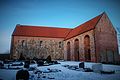
The Minsener church today, on the right the bell tower
Exterior view

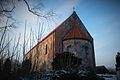
Church with cemetery in the foreground
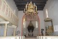
View to the altar
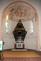
altar
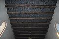
ceiling


Wangerland National Park House

The National Park House Wangerland is located in Minsen . The information center, which opened in 2001 as the North Sea House Wangerland , was officially named a National Park House on June 22, 2012 . The house houses an exhibition on the Wadden Sea National Park and World Heritage Site, as well as information on the use of wind energy on the North Sea coast. The focus of the exhibition is an aquarium system with a capacity of around 7,000 liters of seawater with native fish and crustaceans from the North Sea. The exhibition also includes dioramas with the typical landscape forms of salt marshes , sandbanks and mud flats .
The facility opposite the village church also serves as a tourist information office and serves as an event center for slide shows, photo and painting exhibitions and music events. The National Park House is operated jointly by Wangerland Touristik GmbH , the municipality of Wangerland , Windpark-Bassens-Verwaltungs-GmbH and the Scientific Working Group for Nature and Environmental Protection eV in Jever . The working group is responsible for the scientific and technical support. The building belongs to Wangerland Touristik.
societies
- Civic association
- Tourist Association
- Klönsnackrunde
- Gymnastics wars
- Boßelverein "Wiet genoog"
- Mardi Gras Club FFC
free time activities
- Cycling on a national network of cycle paths
- Nordic walking on the regional route network
- Salt marsh tours
- Events in the National Park House Wangerland
Personalities
- Andreas Luiken (* 1925 in Minsen; † 2012 in Jever ) was a Lower Saxony local and state politician ( CDU ).
See also
literature
- Minsen, een Karkdkör up Klei un ümto (Minsen, a church village on the Klei and around), Geschichtswerkstatt Wangerland eV, 2005
- Hermann Haiduck: The architecture of the medieval churches in the East Frisian coastal area . 2nd Edition. Ostfriesische Landschaftliche Verlags- und Vertriebs-GmbH, Aurich 2009, ISBN 978-3-940601-05-6 , p. 31 .
- Axel Bürgener , Klaus Siewert: Saalkirchen im Wangerland , Verlag "Auf der Warft", Münster - Hamburg - Wiarden 2015, ISBN 978-3-939211-97-6 , p. 36 ff.
- Karl Steinhoff : Village schoolmaster in Minsen (1913) . In: The rope wheel . Heinz Holzberg, Oldenburg 1980, ISBN 3-87358-130-2 , p. 212-216 .
Web links
- Description of mines in the history atlas student project
- Minsen-Förrien tourist office
Individual evidence
- ^ Michael Rademacher: German administrative history from the unification of the empire in 1871 to the reunification in 1990. friesland.html. (Online material for the dissertation, Osnabrück 2006).
- ^ Federal Statistical Office (ed.): Historical municipality directory for the Federal Republic of Germany. Name, border and key number changes in municipalities, counties and administrative districts from May 27, 1970 to December 31, 1982 . W. Kohlhammer GmbH, Stuttgart and Mainz 1983, ISBN 3-17-003263-1 , p. 275 .
- ^ National Park House Wangerland , accessed on February 22, 2013
- ^ Scientific Working Group for Nature and Environmental Protection eV - National Park House Wangerland , accessed on December 11, 2018.
Altgarmssiel | Forrien | Friederikensiel | Hohenkirchen | Hooksiel | Horum | Horumersiel | Middoge | Minsen | Neugarmssiel | Oldorf | Schillig | Tettens | Waddewarden | Wiarden | Wiefels