
Wangerland
| coat of arms | Germany map | |
|---|---|---|

|
Coordinates: 53 ° 39 ' N , 7 ° 57' E |
|
| Basic data | ||
| State : | Lower Saxony | |
| County : | Friesland | |
| Height : | 2 m above sea level NHN | |
| Area : | 175.44 km 2 | |
| Residents: | 9182 (Dec. 31, 2019) | |
| Population density : | 52 inhabitants per km 2 | |
| Postcodes : | 26434, 26441 | |
| Primaries : | 04463, 04464, 04461, 04425, 04426 | |
| License plate : | FRI | |
| Community key : | 03 4 55 020 | |
| Community structure: | 16 districts | |
| Address of the municipal administration: |
Helmsteder Strasse 1 26434 Wangerland |
|
| Website : | ||
| Mayor : | Björn Mühlena (independent) | |
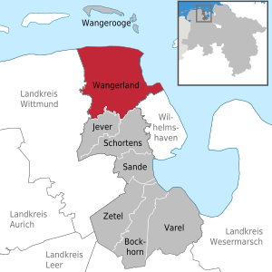
| Location of the municipality of Wangerland in the district of Friesland | ||
  |
||

Wangerland is a municipality in the district of Friesland in Lower Saxony . The municipality with 9,182 inhabitants covers an area of 176 square kilometers and is therefore the largest municipality in the district of Friesland in terms of area. The administrative seat of the municipality is Hohenkirchen .
geography
Geographical location
The municipality of Wangerland is located in the northeast of the East Frisian peninsula directly on the North Sea . In the north and east of the municipality, the 27-kilometer-long North Sea coast runs with its sewage sites. The upstream mudflats belong to the Lower Saxony Wadden Sea National Park , which has been part of the Wadden Sea UNESCO World Heritage Site since 2009.
Community structure

The municipality of Wangerland officially consists of the following 16 districts, which, however, only play a role in connection with the residents' administration:
Altgarmssiel , Förrien , Friederikensiel , Haddien , Hohenkirchen, Hooksiel , Horum , Horumersiel , Middoge , Minsen , Neugarmssiel , Oldorf , Schillig , Tettens , Waddewarden , Wiarden and Wiefels .
There are also other smaller places with a recognizable local structure and some with their own church, the residents of which are assigned to the above-mentioned districts. The administrative seat of the municipality is in Hohenkirchen: The town hall with the municipality is located there.
Neighboring communities
Due to its location on the North Sea, the municipality of Wangerland only has neighbors in the west and south on the mainland. In the west it borders on the city of Wittmund , in the south on the city of Jever , the city of Schortens and the city of Wilhelmshaven . North of the Wangerland is the island of Wangerooge , which forms its own municipality.
Land use
The community has a predominantly rural character. The agricultural area is 15,124 hectares . About a third of this is arable land and two thirds are grassland.
Waters
There are numerous lows in the area of the municipality of Wangerland . They primarily serve to drain the inland areas. In earlier times they were also used as traffic routes, today also for the recreational sports of paddling and fishing . The following lows are to be mentioned: Bübbenser Tief , Crildumer Tief , Hohenstief , Hooksieler Binnentief , Hooksieler Tief , Horumer Tief , Kopperburger Leide , Poggenburger Leide , Südliches Connectionstief , Tettenser Tief , Wangertief and Wüppelser Tief .
To the north of Hohenkirchen is the Wangermeer , an artificially created recreational lake of around 100 hectares.
history

The Gau "Wanga" is already in the days of Charlemagne mentioned when this Willehad the bishop made in the Gau. Settlement finds indicate smaller settlements from the 2nd century BC. Chr. The Wangerland was separated by the Hooks Tief in the south of Östringen and by the Harlebucht in the west of Harlingen. The villages and parishes of Hohenkirchen , Oldorf, Pakens , Tettens , Middoge , Minsen , Waddewarden , Westrum , Wiarden , Wiefels , St. Joost , Wüppels and the island of Wangerooge belonged to Wangerland .
In the 13./14. In the 19th century, Wangerland, Östringen and Rüstringen came together ever closer . From the Wangerland and parts of Östringen and Rüstingen, the Jever rule was finally formed .
Hooksiel was in early times (1583-1870) the outer port of the city of Jever . Troops were stationed in Schillig during the Franco-Prussian War of 1870/71 ( Napoleon Schanze ). During the First World War and the Second World War , parts of the navy were stationed in Schillig . At this time there was a railway line to Schillig , which was reserved exclusively for the navy and the supply of their coastal fortifications.
In the 19th century there were two offices in Wangerland. The Tettens office was responsible for the parishes or localities Hohenkirchen (until 1845), Middoge, Tettens, Wangerooge and Wiefels, the Minsen office (seat of Hooksiel) for Minsen, Oldorf, Pakens, Waddewarden, Westrum, Wiarden, Wüppels, St. Joost . Both offices fell to the office of Jever in 1858 ( see also Herrschaft Jever ).
Through the law on the simplification and cheaper public administration (Simplification Act) of April 27, 1933, a new large municipality was formed from the previous municipalities of Oldorf, Hohenkirchen, Middoge, Tettens, Wiefels and Westrum, which was named Wangerland and had 4,215 inhabitants in 1933 would have. In 1948 the municipality of Wangerland was dissolved by the law on the formation of new municipalities in the Lower Saxony administrative district of Oldenburg of April 26, 1948. The communities Hohenkirchen , consisting of the districts of the old communities Hohenkirchen and Oldorf, Tettens , consisting of the districts of the old communities Middoge, Tettens and Wiefels, and Waddewarden , consisting of the districts of the old communities Waddewarden and Westrum, were newly formed.
Today's municipality of Wangerland has existed since February 1, 1971. The municipality was formed as a unitary municipality as part of the regional reform of the State of Lower Saxony from the municipalities of Hohenkirchen (Oldenburg), Minsen and Tettens. Since this region north of Jever has been known as the Wangerland for centuries, the municipality was given this name. On July 1, 1972, Hooksiel and Waddewarden were incorporated.
The Wangerland history workshop was founded in 1990 to maintain regional identity . Since then, the association has published numerous chronicles.
politics
advice

The council of the municipality of Wangerland consists of 24 council women and councilors. This is the specified number for a municipality with a population between 9,001 and 10,000. The council is elected for a five-year term by local elections. The current term of office began on November 1, 2016 and ends on October 31, 2021.
The full-time mayor Björn Mühlena (non-party candidate of the SPD) is also entitled to vote in the council of the municipality.
The last local election on September 11, 2016 resulted in the following:
| Political party | Proportional votes | Number of seats | Change voices | Change seats |
|---|---|---|---|---|
| SPD | 42.29% | 10 | +1.41% | +1 |
| CDU | 35.28% | 8th | + 6.37% | +2 |
| Alliance 90 / The Greens | 10.30% | 3 | −2.22% | 0 |
| UWW | 6.56% | 2 | −2.21% | 0 |
| FDP | 5.54% | 1 | + 0.83% | 0 |
The turnout in the 2016 local elections was 54.15%, slightly below the Lower Saxony average of 55.5%. For comparison - in the previous local election on September 11, 2011, the turnout was 50.71 percent.
mayor
Björn Mühlena is the full-time mayor of the municipality of Wangerland. In the last mayoral election on May 25, 2014, the non-party, SPD-supported Mühlena received 55.24 percent of the votes in the first ballot and was able to beat his competitors Rainer Hinrichs (25.74 percent) and Reiner Tammen (19.01 percent) enforced. The turnout was 54.26 percent. Mühlena took office on November 1, 2014.
Representatives in the Land and Bundestag

In the elections to the Lower Saxony state parliament , the municipality of Wangerland belongs to the state electoral district 70 Friesland , which includes the entire district of Friesland. The direct mandate was won on October 15, 2017 by Olaf Lies from the SPD. On November 22, 2017, Lies was elected Minister for the Environment, Energy, Building and Climate Protection of Lower Saxony. The electoral term ends in 2022.
The community belongs to the federal constituency of Friesland - Wilhelmshaven - Wittmund . It includes the city of Wilhelmshaven and the districts of Friesland and Wittmund . The directly elected MP is Siemtje Möller (SPD). No party candidate from the constituency entered the Bundestag via the parties' list.
coat of arms

|
|
Blazon : "On a blue background the Seewiefken with bare upper body and the blonde hair plaited in a braid, the right hand with a threatening index finger, the silver, scaly-covered lower body ending as a tail fin." |
|
Justification of the coat of arms: The coat of arms of the municipality of Wangerland shows a mermaid on a blue background , the Seewiefken (Frisian nickname from Seewief for Seeweib). Her torso is bare and her blonde hair is braided in a braid. She holds up her right hand with a threatening index finger. The silver, scale-covered lower body ends as a caudal fin.
The heraldic figure is based on an old legend that was written down in the 16th century. Then fishermen from Minsen, which is said to have been located on the island of Minsener Oog , caught a mermaid with a fish abdomen. She was able to escape to the North Sea again and, out of revenge, destroyed the village settlement with a storm surge. Historically, however, it is doubtful that an earlier Minsen was on an island. A bronze sculpture is dedicated to this story, which is set up in the district of Norderaltendeich near Minsen near the dike. The sculptor and painter Karin Mennen from neighboring Horum created the larger than life figure of the mermaid in 1992. |
Culture and sights
Attractions


In Hooksiel, the community maintains the Hooksiel artists' house in the former Hooksiel town hall , where visual artists are supported through scholarship stays. Fischhausen Castle is near Hooksiel , a former chief's seat, with some parts from the Renaissance ( stair tower , Renaissance fireplace in the knight's hall ). In the Horumersiel district is the Stumpenser Windmühle , a gallery Dutch built in 1816 . In Minsen is the National Park House Wangerland , the national park house of the community, which houses an exhibition on the national park and the Wadden Sea World Heritage Site as well as information on the use of wind energy on the North Sea coast. The landmark of Hohenkirchen is around 30 meters high and highly visible water tower Hohenkirchen . The water tower was built in 1934 as a clinker brick building according to plans by the Hamburg architect Fritz Höger .
Evangelical sacred buildings
In the Wangerland there are several, partly important medieval churches, all of which were built on terps . The Protestant Church of St. Sixtus and Sinicius in Hohenkirchen is a late Romanesque granite block building from the first half of the 13th century with two outstanding works by Ludwig Münstermann , the altarpiece and the pulpit. The Protestant church in Oldorf is a brick building with a granite ashlar plinth from the 13th century. The crucifixion altar and the baptismal font are from around 1500. The Evangelical Church of the Holy Cross is in Pakens . It is a Romanesque granite block building that was built around the year 1270. The church responsible for Hooksiel and Pakens is not located in the old town center of Hooksiel, but in the much older village of Pakens, about two kilometers away. The organ of the church was created in 1664 by Joachim Richborn from Hamburg. The Protestant church in Wüppels is a little off the road between Hooksiel and Horumersiel. It is a granite block building from the beginning of the 13th century. In the village of St. Joost there is the small evangelical church St. Jodocus from the 15th century. The building block was named after Saint Jodocus , the patron saint of travelers and seafarers. The Evangelical Church of St. Cosmas and Damian in Wiarden is said to have existed as early as 1164. The choir of the Romanesque granite block contains remains of late Gothic wall paintings from the 13th century depicting the apostles Peter, Jacobus and Johannes as well as the patron saints of the church, St. Cosmas and Damian. The Protestant Church of St. Martin in Tettens also has granite masonry that dates from the first half of the 13th century. The 36 meter long hall church has significant furnishings. Inside is u. a. a tower-like sacrament house from around 1525 can be seen. The winged altar of the church dates from 1520 and shows the crucifixion of Christ in the middle, scenes from the life of Saint Martin and Saint Thomas are depicted on the wings . The Protestant church in Middoge dates from the late 15th century and is a single-nave brick building. The Evangelical Church of St. John is in Waddewarden . It is a medium-sized hall building from the first half of the 13th century, 41.3 meters long, with granite blocks up to 2 meters high. The apse, which is made entirely of granite blocks, contains late Gothic wall paintings. In the village of Westrum there is the church of St. Elisabeth from the middle of the 13th century, which was mentioned as badly damaged as early as 1420. It is a brick building; the church was thoroughly renovated in 1912. The Protestant church in Wiefels was also described as badly damaged in 1420. It dates from the second half of the 13th century and has granite ashlar work in the lower part and brick above. Almost all churches contain works of art from different centuries. The bell towers or belfries are like almost all churches on the East Frisian peninsula separately in each case in addition to the churches.
Roman Catholic sacred buildings
The St. Marien Church was built in Schillig in 1967 . After demolition, a new church was built on the old site, which was consecrated in 2012.
Another Catholic place of worship, the St. Ansgar Church , is located in the Hooksiel district . It was built in 1966 and expanded significantly in the early 1980s. It has had a pipe organ with six registers since 2009, which comes from the workshop of Martin ter Haseborg (Uplengen).
A third Catholic community center, the St. Hedwig Church, was located in Hohenkirchen. It was built in 1975 and also served as a garrison church for the Catholic Bundeswehr members of the Wangerland barracks. After the barracks closed, the number of parishioners decreased considerably. It was therefore profaned on May 30, 2007 and, since no buyer could be found, demolished at the end of 2009. Today there is a private house on the church property.
UNESCO World Heritage Wadden Sea
The Wadden Sea, a UNESCO World Heritage Site, stretches for around 12,000 square kilometers along the North Sea coast from Den Helder in the Netherlands to Esbjerg in Denmark. Of this, 4,700 km² (on average) fall dry at low tide. The area is considered to be the world's largest contiguous watt island area. Parts of it have been UNESCO World Heritage Sites since June 2009.
Economy and Infrastructure
tourism


Due to the immediate location on the North Sea, there is considerable tourism in the community. Its economic importance is shown by the number of overnight stays. In 2014 there were 307,172 overnight guests with a total of 2,001,020 overnight stays. The average length of stay was 6.51 days. More than half of the holidaymakers are in Wangerland again.
In 1992 the municipal spa administration was converted into Wangerland Touristik GmbH . All districts are recreational areas, Horumersiel-Schillig is a North Sea spa , Hooksiel and Minsen have the status of coastal resorts .
The hotel and leisure complex “Dorf Wangerland” is located north of Hohenkirchen. The facility was built in 2006 on the site of a former disused Bundeswehr barracks. The partial opening took place in spring 2008. The "Dorf Wangerland" includes eight hotel buildings with 600 beds in 231 rooms, restaurants with 660 seats, an event house for up to 300 visitors, a skittles and bowling center and the "North Sea Play City Wangerland" on around 5700 square meters in three halls. The facility borders the approximately 100 hectare , artificially created Wangermeer , which was created as part of dike heightening measures near Minsen .
The Wangerland pilgrimage route has existed since 2004 and connects 14 partly important medieval churches in the community. In contrast to the classic pilgrimage routes , the Wangerland pilgrimage route is preferred to be traveled by bike. In addition, you can largely determine the route yourself, as the pilgrimage route does not specify a fixed route with a start or end point. It can be explored by bike in a day or two.
On the basis of Section 59 (1) BNatSchG , those seeking relaxation have sued the municipality of Wangerland for free access to the beach. The Federal Administrative Court ruled in 2017 that the fencing and management of almost the entire beach in the municipality as a chargeable communal lido is illegal.
traffic
The community is connected to the A 29 federal motorway (Fedderwarden junction) via the L 810 state road. The state roads L 808 and L 812 lead to junctions of the federal road 210 , which crosses the East Frisian peninsula in an east-west direction .
The municipality of Wangerland is connected to Wilhelmshaven and Jever by the Weser-Ems Bus . In the summer and autumn holidays, there is also a tourist bus service. The municipality of Wangerland is in the area of the Ems-Jade transport association .
Until 1988 the Wangerland was connected to the rail network via the Jever – Harle railway line. It was a 20-kilometer branch line that was largely used for traffic in connection with the Wangerooge ferry. Since this crossing is dependent on the tides , the train schedule was also adapted and mostly changed daily. The rides were as Tidezug called and the track as Tidebahn. Since the end of the railway, the connection has been served by buses. In the Hohenkirchen part of the municipality, the naval railway branched off to Schillig , which was dismantled in 1949.
Wind energy


Since 1996 there on arable and grassland between the districts Bassens, Funnens and Grimmen the wind farm Bassens . The facility, operated as a community wind farm, is located about 500 m from the North Sea dike and originally consisted of 34 wind turbines from AN Bonus, each with a nominal output of 600 kW . All 34 plants belonged to the farmers and citizens of the municipality of Wangerland who lived there. With around 45 million kilowatt hours (kWh) per year, the output of the system was roughly equivalent to the amount of electricity supplied to around 10,000 households. In 2006 the wind farm was expanded by 3 turbines with a total of 6 MW, the total output was 26.4 MW.
Repowering was decided in 2013 and was implemented by spring 2014. The 34 old systems were dismantled and replaced by 10 modern wind turbines of the Siemens SWT-3.0-113 type , each with a nominal output of three MW and a rotor diameter of 113 meters. With an output of now 36 MW, the wind farm will now supply electrical energy for around 20,000 households after the renovation.
Personalities
Sons and daughters of the church

- Dietrich Behrens (1859–1929), professor of Romance philology at the University of Giessen, privy councilor, born in Sophiengroden
- Peter van Bohlen (1796–1840), orientalist, born in the Wüppels district
- Gerhard Anton Gramberg (1744–1818), urban and rural physicist in Oldenburg (Oldenburg) , born in Tettens
- Hero Diedrich Hillerns (1807–1885), Grand Ducal Oldenburg Senior Building Officer, born in Tettens
- Hermann Friedrich Wilhelm Hinrichs (1794–1861), theologian, philosopher and political writer, born in Karlseck
- Laurentius Michaelis from Hohenkirchen († 1584), printed the first map of the County of Oldenburg
- Theodor Pekol (1888–1958), bus manufacturer and transport operator, born in Horumersiel
- Hans Christoph Peters (1797–1868), chief dichgrave in the Grand Duchy of Oldenburg , born in Wiefels
- Jakob Schipper (1842–1915), German-Austrian philologist and English scholar, born in Friedrich-Augustengroden
- Ulrich Jasper Seetzen (1767–1811), doctor, scientist, naturalist, traveler and orientalist, born in Sophiengroden
- Johann P. Tammen (* 1944), writer, born in Hohenkirchen
- Johann Heinrich von Thünen (1783–1850), agricultural and economic scientist , born in Canarienhausen
- Friedrich von Thünen (1785–1865), farmer and politician, born in Canarienhausen
- Johann Ludwig Tiarks (1789–1837), member of the Anglo-American Border Commission after the Peace of Ghent in 1814 a. a. (see Waddewarden )
- Uwe Zink (* 1952), German politician (SPD), born in Bübbens
Personalities associated with the community
- Heinrich Schütte (1863–1939), local researcher, spent formative years in the Groden area and researched in the Wangerland
- Heinrich Steinberg (1913–1995), 1952–1959 mayor of Hohenkirchen and poet
See also
literature
- Erhard Ahlrichs : Horumersiel - Vom Sielort zum Nordseeheilbad , Ed .: Gemeinde Wangerland, Isensee-Verlag, Oldenburg 1992, ISBN 3-89442-130-4 .
- Georg Dehio : Handbook of German Art Monuments - Bremen, Lower Saxony , Deutscher Kunstverlag, 2nd edition, Berlin / Munich 1992, ISBN 3-422-03022-0 .
- Hermann Lübbing: Oldenburg, historical contours. Heinz Holzberg Verlag, Oldenburg 1971, ISBN 3-87358-045-4 .
- Almuth Salomon : castles and chiefs in the Wangerland. In: Emder Jahrbuch, 67th Volume 1987, pp. 38–54.
- Almuth Salomon (edit.): Explanatory booklet for the historical and cultural excursion map of Lower Saxony. Sheet Wangerland / Hooksiel-West. (= Publications of the Institute for Historical Research at the University of Göttingen; 2, part 10), Ed .: Ehrhard Kühlhorn, Gerhard Streich, Hildesheim 1986, ISBN 3-7848-3630-5 .
- Georg Sello : The territorial development of the Duchy of Oldenburg. Oldenburg 1917.
- Georg Sello: Östringen and Rüstringen: Studies on the history of land and people. After the author's death, ed. by his son, publishing house Ad. Littmann, Oldenburg 1928, ( digitized ).
- Carl Woebcken : Jeverland. What has been and what has remained. In: Issue 8 of the communications of the Jeverland antiquity and homeland association , Verlag CL Mettcker & Sons, Jever 1961, DNB 455728933 .
Web links
- Website of the municipality of Wangerland
- Places of the Wangerland in the Lower Saxony Historical Atlas
- Churches in the Wangerland
- Historical place Wüppels in Wangerland
- Municipality map of the state of Oldenburg (1937)
- Wangerland Touristik GmbH
Individual evidence
- ↑ State Office for Statistics Lower Saxony, LSN-Online regional database, Table 12411: Update of the population, as of December 31, 2019 ( help ).
- ↑ According to an email from Wangerland's Mayor Björn Mühlena on December 29, 2015.
- ↑ Section I, Chapter 1, §§ 1, 2. No. 7 Simplification Act of April 27, 1933 (Law Gazette for the Free State of Oldenburg - Oldb.Ges.Bl. - p. 176 f.)
- ^ Michael Rademacher: German administrative history from the unification of the empire in 1871 to the reunification in 1990. friesland.html. (Online material for the dissertation, Osnabrück 2006).
- ↑ Sections 4 and 5 Nos. 8, 22 and 23 Act on the New Formation of Communities in the Lower Saxony Administrative District Oldenburg of April 26, 1948 (Lower Saxony Law and Ordinance Gazette - Nds. GVBl. - p. 50 f.)
- ^ Federal Statistical Office (ed.): Historical municipality directory for the Federal Republic of Germany. Name, border and key number changes in municipalities, counties and administrative districts from May 27, 1970 to December 31, 1982 . W. Kohlhammer, Stuttgart / Mainz 1983, ISBN 3-17-003263-1 , p. 275 .
- ^ Geschichtswerkstatt Wangerland eV , accessed on September 8, 2012.
- ^ Lower Saxony Municipal Constitutional Law (NKomVG) in the version of December 17, 2010; Section 46 - Number of MPs , accessed on November 9, 2016.
- ↑ a b Wangerland municipality - municipal council election 2016 , accessed on October 22, 2016.
- ↑ The CDU gets the most votes nationwide. September 12, 2016. Retrieved November 9, 2016 .
- ^ Wangerland municipality - result of the mayoral election on May 25, 2014 , accessed on October 22, 2014.
- ↑ Olaf Lies: About me , accessed on August 17, 2019
- ↑ Allocation of constituencies to the Federal Returning Officer , accessed on May 22, 2019.
- ^ Nordwest-Zeitung: Bundestag election: These members represent our region . In: NWZonline . ( nwzonline.de [accessed September 29, 2017]).
- ^ National Park House Wangerland , accessed on February 9, 2014.
- ^ Catholic Church Wangerland: St. Ansgar Hooksiel ; accessed on February 9, 2014.
- ^ Catholic Church Wangerland: Hooksiel and Hohenkirchen ; accessed on February 9, 2014.
- ↑ Wangerland Touristik GmbH: Guests visiting the resort area of Wangerland, Statistics 2014 , accessed on 12 January 2016th
- ↑ North Sea Spa Horumersiel: The box seat at the gateway to the North Sea , accessed on January 12, 2016.
- ^ Dorf Wangerland - Chronik , accessed on February 9, 2014.
- ↑ The altar has a treasure on the back , accessed on February 9, 2014.
- ↑ Wangerland pilgrimage route , accessed on January 12, 2016.
- ↑ BVerwG , judgment of 13 September 2017, 10 C 7.16
- ↑ 34 MW: Siemens is supplying ten systems for a community wind farm . In: IWR , July 19, 2013. Retrieved July 19, 2013.
- ↑ Wangerländer can sign wind farm savings bonds . In: Wilhelmshavener Zeitung , May 2, 2014. Accessed February 17, 2015.
- ↑ Klaus A. Zugermeier: Life and Work of the Grand Ducal Oldenburg Senior Building Councilor Hero Diedrich Hillerns (1807–1885) , Heinz Holzberg Verlag, Oldenburg 1983, ISBN 3-87358-172-8 .
- ^ Maps and plans from the library of the castle museum , accessed on June 28, 2017.
- ↑ Rudolf Wyrsch, Albrecht Eckhardt: 155 Oldenburg Heads - the photo album for Oberdeichgräfen Hans Christoph Peters from 1867 , Isensee Verlag, Oldenburg 2010, ISBN 978-3-89995-699-3 .
- ^ Heinrich Schütte: The geological structure of the Jever and Harlingerland and the first settlement on the march , in Oldenburger Jahrbuch 37 (1933), Stalling Oldenburg 1934.
Bockhorn | Jever | Sands | Schortens | Varel | Wangerland | Wangerooge | Zetel
Altgarmssiel | Forrien | Friederikensiel | Hohenkirchen | Hooksiel | Horum | Horumersiel | Middoge | Minsen | Neugarmssiel | Oldorf | Schillig | Tettens | Waddewarden | Wiarden | Wiefels