
Wangerland pumping station
| Wangerland pumping station | |
|---|---|
 Wangerland pumping station |
|
| Data | |
| place | Municipality Wangerland , district Horumersiel |
| Construction year | 1973 |
| Coordinates | 53 ° 40 '27.9 " N , 8 ° 1' 12.1" E |
The Wangerland pumping station drains the 26,000 hectare catchment area of the Sielacht Wangerland via the Wangertief into the North Sea .
function
The pumping station was built from 1971 to 1973 about two kilometers south of Horumersiel . Its four propeller pumps are able to pump a total of 54,000 liters of water per second from the Hohenstief into the Wangertief. In this way, the drainage of the previously merged sluices from Horumersiel, Hohenstiefersiel, Crildumersiel and Hooksiel can be ensured via the Wangersiel.
In 2007 the system was converted to automatic operation. In addition to the main Wangerland pumping station itself, the Moorland and Wiedel lower pumping stations as well as the Wangersiel in neighboring Horumersiel are controlled from here.

Aerial view of the pumping station

The pumps of the pumping station
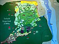
Information board with the catchment area of the Sielacht Wangerland


Web links
- Hohenstiefersiel pumping station ( memento from April 11, 2015 in the Internet Archive ), accessed on September 24, 2018
- Sielacht Wangerland , accessed on September 24, 2018
Individual evidence
- ^ Theo Kruse: Schöpfwerk: Mortgage removed 50 years ago . In: Nordwest-Zeitung . January 7, 2015 ( nwzonline.de [accessed October 29, 2018]).
- ^ Sielacht Wangerland. Water and Soil Associations Friesland / Wilhelmshaven, accessed on October 29, 2018 .