
Wangerooge
| coat of arms | Germany map | |
|---|---|---|

|
Coordinates: 53° 47′ N , 7° 54′ E |
|
| basic data | ||
| State : | Lower Saxony | |
| county : | Friesland | |
| height : | 3 m above sea level NHN | |
| Area : | 4.97km2 _ | |
| Resident: | 1214 (Dec 31, 2020) | |
| population density : | 244 inhabitants per km 2 | |
| Zip code : | 26486 | |
| area code : | 04469 | |
| License plate : | FRI | |
| Municipality key : | 03 4 55 021 | |
| LOCODE : | DE AGE | |
| Municipal administration address : |
Peterstrasse 6 26486 Wangerooge |
|
| site : | ||
| Mayor : | Marcel Fangohr ( independent ) | |
| Location of the municipality of Wangerooge in the district of Friesland | ||
  |
||

.png)
Wangerooge (formerly and Low German Wangeroog ; correct pronunciation "Wanger-ooge") is an island in the Lower Saxony Wadden Sea within the national park of the same name . It is the easternmost of the seven inhabited East Frisian Islands and with an area of 7.94 square kilometers it is the second smallest inhabited island in this group. Wangerooge is the only one of the inhabited East Frisian islands that does not belong to the historical territory of East Frisia , but is historically part of the Frisian Jeverland and the state of Oldenburg .
Tourism is the central economic factor on the car-free island today . It is also a North Sea health resort . The island of Wangerooge is a unitary municipality in the district of Friesland in Lower Saxony and has a good 1,200 inhabitants. The uninhabited neighboring island of Minsener Oog also belongs to the political community .
geography
position


Wangerooge is a German island in the southern North Sea . It is the easternmost of the seven inhabited East Frisian islands. The island stretches 8.5 kilometers in east-west direction. The north-south extension is a maximum of 2.2 kilometers in the western part, 1.2 kilometers at the level of the town. The distance to the mainland is seven kilometers. To the west of Wangerooge, separated by the Harle strait , lies the eastern end of Spiekeroog , two kilometers away . The island of Minsener Oog begins two kilometers east-southeast, separated by the strait of the Blue Balje . On the north side there is a sandy beach about 100 meters wide and three kilometers long . To the east it merges into a 500 meter wide and three kilometer long field of sand deposits. In the west of the island there are two more beaches of half a kilometer and one kilometer long. South of the island lies the Wadden Sea , which, like the islands, belongs to the Lower Saxony Wadden Sea National Park and largely dries up at low tide . The Geest base is located under the island at a depth of about 15 meters . The highest elevation on the island is the viewing dune at 17 m above sea level. NHN ; a viewing platform was set up on it in 1990. The remaining sand dunes reach heights of up to 12 meters.
surface
With an area of 7.94 square kilometers (2008), Wangerooge is the second smallest island of the inhabited East Frisian Islands after Baltrum , occasionally larger area values (up to 8.5 square kilometers) are given. Beach areas that are below the mean high tide line (MTHW) are included in higher figures. These are regularly washed over by the seawater of the North Sea and are therefore not considered land areas. Since part of the land area (2.97 square kilometers) is not de-municipalised as part of a federal waterway , the area of the municipality of Wangerooge covers only 4.97 square kilometers.
population
The updated population as of December 31, 2011 based on the last census of May 25, 1987 was 868 inhabitants. This value had to be corrected due to the 2011 census : As of May 9, 2011, the island had 1278 or 1311 inhabitants. The unusually strong correction of 47.2% was the highest value in Germany for a municipality of this size. Of all the municipalities in Germany, only five very small municipalities between 23 and 203 inhabitants in the state of Rhineland-Palatinate and the Hallig Gröde had higher percentage correction values .
landscapes

Wangerooge consists of the landscape types:
- Beach (2.5 square kilometers)
- Eleven km of dunes (1.7 square kilometers) and 6 km of dikes
- Outside groden as a salt marsh (about 2.1 square kilometers)
- Inner Groden as a march (about 2.1 square kilometers) with:
In the West Outer Groden there is a salt water lake called Lagoon . It was created in 1912 when sand and silt were dug out to build the dyke (Westgrodendeich). The shallow lake has become a resting place for seabirds .
In earlier centuries, the mud flats between the island and the mainland seem to have been flatter. It is reported from the 15th century that the lord of Jever Tanno Duren drove to the island with a horse and cart. In the 18th century there was a path between Minsen and Wangerooge, called Strick-Pad (a path partly covered with water), which was used as a footpath; cattle were also driven over here.

View of the island when the ship arrives at the western pier, with the western tower

Two water-filled bomb craters from 1945 in the inner groden, dunes behind them

Ostend with the now demolished Ostbake Wangerooge , view from the dunes across the mud flats to the mainland

Remains of the jetty and the Wangerooger Inselbahn at the east end


South and East Drift

Like the other islands in the East Frisian island chain, Wangerooge has shifted steadily over the centuries due to the influence of wind and sea currents . Wangerooge has experienced the greatest changes in shape and position and is considered the most unstable of the island chain. This development can be traced using historical maps that have existed since around the 17th century. Not only was there a southward migration associated with the mainland incursion of Harle Bay in the 14th century, but far more massive was the west-east drift resulting from the eastward tidal current and the nagging activity of the Harle's sea gust. As a result, between the 17th and 19th centuries, the island lost about two kilometers of land in the west and increased in length by about four kilometers in the east.
As a result of the shift, settlements had to be abandoned and relocated to the east time and again over the course of the island's history. In 1586 the sea in the west destroyed the old west tower of St. Nicolai's church, traces of which could still be seen in 1821 at low tide . After that, in 1602, a tower was built, which at that time was still in the east of the island; over time it became the west tower again.
climate
Wangerooge lies in the area of a temperate, summer-cool maritime climate influenced by the Gulf Stream . With small temperature fluctuations, there is high humidity. With an average of 1670 hours a year, the mean sunshine duration is above the German average of 1550 hours. The mean amount of precipitation is 787 millimeters per year. There are about 50 frost days a year.
| Wangerooge | ||||||||||||||||||||||||||||||||||||||||||||||||
|---|---|---|---|---|---|---|---|---|---|---|---|---|---|---|---|---|---|---|---|---|---|---|---|---|---|---|---|---|---|---|---|---|---|---|---|---|---|---|---|---|---|---|---|---|---|---|---|---|
| climate diagram | ||||||||||||||||||||||||||||||||||||||||||||||||
| ||||||||||||||||||||||||||||||||||||||||||||||||
|
Monthly average temperatures and precipitation for Wangerooge
Source: wetterkontor.de
|
|||||||||||||||||||||||||||||||||||||||||||||||||||||||||||||||||||||||||||||||||||||||||||||||||||||||||||||||||||||||||||||||||||||||
national park
The island is part of the Lower Saxony Wadden Sea National Park. It is therefore subject to the zoning of the park with areas of different protection status:
-
Zone I (quiet zone) with the strictest protection regulations may only be entered in exceptional cases or on marked paths. The route across the two dykes (Westdeich and Neudeich) gives visitors the opportunity to observe animals and nature in this particularly protected zone. It includes:
- West Outer Groden (with the West Lagoon)
- Parts of the western inner Groden
- middle outer groden
- Part of the Ostinnengroden delimited by the Neudeich
- East Outer Groden from the Neudeich to the Ostend
-
Zone II (intermediate zone) with temporary free access consists of:
- Part of the western inner Groden
- Dune sections between west village and main town
- Area around the airfield in Ostinnengroden
- Chain of dunes between the main town and Ostend
-
Zone III (recreational zone) for holiday and spa operations with the remaining sections of the island, such as:
- Main beach in the area of the place
- beach around the west end
- Town center with buildings
National Park bases
The Wangerooge National Park House was set up in 1989 in the rose house of the rose park as an information and educational facility . In its exhibition rooms, it provides information about the national park, the island, nature conservation and the habitats of mud flats, salt marshes and dunes. The facility runs a variety of themed events and has around 40,000 visitors a year. In 2014/2015 the rose house was renovated and expanded. During this time, the National Park House used the rooms of the elementary school on Nikolausstrasse.
Two other bases of the national park are located in the east and west of the island. These are wooden houses in which volunteer helpers from the nature conservation organization Mellumrat are housed.
Flora and fauna


The island's flora is characterized by the original lack of vegetation on the island's surface, which often silted up due to sandstorms. Smaller forest and bush areas were only created through targeted reforestation. These are in the east of the island the jade grove near the waterworks and an approximately 7 ha strip of woodland made up of poplars and willows north of the airfield. The undemanding potato rose found ideal living conditions on the island and has spread rapidly across the dunes since it was first planted in 1936. Many of the bomb craters from the 1945 air raid , which are now filled with water , have developed into ecologically valuable small biotopes .
The fauna of the island is rich in species. When the birds are migrating, large flocks of migratory birds rest on the island . The mudflats serve as a rich source of food for the huge swarms with mussels, worms and other small creatures. Ducks and geese use the salt marshes as grazing grounds. About 200 guest bird species can be observed annually, the most common being dunlins , curlews , knots , lapwings and shelducks . Other bird species that occur are diving ducks , redshank , eider duck , scoter duck , oystercatcher , sandwich tern , golden plover , pelagic seabirds, black- headed gull , herring gull . Around 80 species of birds breed on the island, including around 45 species of songbirds. Hares and pheasants live in the dunes . Kestrels hunt over the dunes , and short- eared owls and hen harriers can also be observed.
There are wood lizards , sand lizards and the rare natterjack toad on the island .
There are 18 species of diurnal butterflies . Among them are the ocher satin and fritillary species, which are rare on the mainland . The latter has a retreat area on the East Frisian Islands that is important for the whole of Germany.
On Wangerooge, the State Association of Beekeepers Weser-Ems operates an island mating station for honey bees of the Carnica breed. Due to the island location, only the drones desired by the beekeepers are suitable for mating with the queen bees . They are in bee colonies on the mating station.
Surname
The name Wangerooge is made up of the old Germanic word Wanga for meadow and the Frisian word Oog for island, which can be interpreted as a meadow island in direct translation . However, the island is named after the Wangerland (meadow land), which the island is located in front of. The name Wangerooge means: the island belonging to the Wangerland . The Wangerland in turn takes its name from the old Frisian Gau Wanga, which was already mentioned in the times of Charlemagne . Settlement finds in this area date back to the 2nd century BC. Chr. Wangerooge was first documented as Wangarou in 1306 in a contract on beach law issues between the city of Bremen and the district of Östringen . In 1327 the island was named Wangeroch . Today's name has been common since around 1800. Wangerooge is the island belonging to the Wangerland (= Oog). Since the Middle Ages , the area north of Jever , roughly in the triangle formed by the towns of Harlesiel , Schillig and Hooksiel , including the island of Wangerooge, has been known as Wangerland. Today, the greater municipality of Wangerland on the mainland bears this name. The island does not belong to you, but it is a unitary municipality in the district of Friesland .
The island has been called Wangerooge since 1885, earlier names were Wangeroich (1532), Wangero (1597), Wangeröhe (1613), Wrangeroog (1757) and then Wangeroog (similar to Langeoog or Spiekeroog ). When the name was changed in 1885, the Grand Duchy of Oldenburg added an "e" to Wangeroog by decree , against the objection of the islanders .
According to the etymology of the island name - Oog/e for island - the pronunciation is something like "Wanger-Ooge", whereby the first or second to last syllable is alternatively stressed: ( IPA ) vaŋɐˈʔoːɡə or ˈvaŋɐʔoːɡə . In German media, on the other hand, the incorrect pronunciation ˈvaŋɐʁoɡə can occasionally be heard, which roughly corresponds to "wange-roge", mostly with an emphasis on the first syllable.
story
prehistory

According to one hypothesis, the East Frisian Islands formed around 3000 BC. BC as sandbanks on the flat North Sea bed, on which the wind blew up dunes. Since then, the elevations have constantly changed their position in the interplay of currents, swell and wind. As a result, there are no prehistoric finds on Wangerooge.
middle age
A settlement on Wangerooge was first mentioned in a document in 1306 in a beach law agreement between Bremen and the Frisian district of Östringen . Another mention was made in 1327 in documents about negotiations for the release of ship captain Thithard, who came from Wangerooge. Due to a storm, he had taken his ship to Zeeland and fallen into the power of the Count of Holland . Due to the first mention of a "villa" Wangerooge in 1327, the existence of a castle on the island in the form of a stone house is assumed. This is also indicated by a Low German sea book from 1470, which is compiled from older writings. A stone house is listed there as a landmark. During the time of the chiefs from 1350 to 1464, the East Frisian islands, including Wangerooge, belonged to the dominion of the tom Brok family . Wangerooge is mentioned in a document from 1398. In it, Widzeld tom Brok ceded his lands, including Wangeroch, to Duke Albrecht of Bavaria as Count of Holland, and received them as a fief from him .
Sea threat and island protection


Wangerooge as it appears today is a man-made island with a stable location and shape. This is due to the extensive island protection measures that were started in the middle of the 19th century. Without them, the island would likely have migrated into the Jade Current .
Until the All Saints' Flood in 1570 , the island village around the St. Nicolai Church consisted of around 50 houses. Around 1650 there were 60 houses with 360 residents on the island. Due to the Christmas flood in 1717 with its destruction, the population declined, and for 1775 only 150 people in 28 houses have survived.
With the New Year's flood of 1855 , a severe storm surge tore the island into three parts. The main island only had an area of 175 ha (to compare: today it is around 500 ha). The flood caused severe destruction in the old island village around the then west tower, with only the tower completed in 1602 remaining standing. Most residents (233) left the island. The Oldenburg government wanted to give up the island completely and settled most of the islanders on the mainland in Hooksiel and near Vareler Hafen. The settlement near Varel, where Wangerooger Island Frisian was spoken longer than on the island itself, still bears the name "Neu-Wangerooge". This meant that Alt-Wangerooge had ceased to exist as a settlement. 82 Wangeroogers refused to leave the devastated island after the New Year's flood. In 1865 they founded a new island village in what was then the east of the island at the old lighthouse, which was completed in 1856.
Prussia was interested in Wangerooge in the middle of the 19th century . The state planned a naval port on the North Sea in Wilhelmshaven for the Prussian Navy . From 1871, the German Reich as Prussia's successor invested more than a million marks for the protection of the island. First, the three parts of the island, which had been torn apart up to that point, were connected in 1874 by the Reichsdeich and the Reichsmauer. Stabilizing revetments were built on the endangered cliff edge in the north-west . Dikes and groynes also secured the island against the drift of its sand masses to the east into the Jade Fairway (the shipping channel to the naval port). The groyne structures of the Minsener Oog adjoining to the east served the same purpose .
In the 20th century, severe storm surges hit the island in 1906, 1916, 1926, 1936, 1973 and 1976. The last major storm surge to cause damage in the island village was the February 1962 storm surge . In the process, water penetrated from the mudflat side in the south to the town center and at that time also flooded the still undeveloped Dorfgroden . To commemorate the flood, a memorial was erected on the dyke south of the Dorfgroden development area, which consists of the old dyke gate that was broken at the time . The flood also hit the protective works on the north-west side badly. They were then reinforced between 1962 and 1964 as a cast revetment with rubble and concrete blocks.
Today, the island's body on the sea side is protected against waves and sea currents by dunes , on which there are further protective devices made of revetments over a length of around four kilometers. Most of the dunes have only formed as a result of measures since the beginning of the 20th century and, as the most important element, are subject to special protection against storm surges. Entering the (mostly fenced in) dunes on the beach is therefore not permitted. Another special protective device is the groyne H, which is the largest groyne structure on the German North Sea coast. Starting in 1938, it was built into the Harle 's strait from the western end over a length of 1½ kilometers , but was not completed because of the war. To protect the Wadden side of the island, a six-kilometre-long dyke was built at the beginning of the 20th century . 80 prisoners from the prison in Vechta were involved in its construction. The dike construction primarily served to secure land, but also to gain grassland for pasture and hay by removing salt marshes from the influence of the sea. After the 1962 hurricane, the dikes were extended and raised to 6 m. Despite all security measures, the sandy beach near the island village regularly loses large amounts of sand due to the storms in autumn and increasingly also in winter and spring. To compensate, these quantities have to be replaced annually from March 15th by bringing sand from Ostend, which is very expensive and is carried out by the spa administration. Further measures are carried out by the Wilhelmshaven Waterways and Shipping Office, whose tasks include securing the island to maintain a stable Jade fairway.
In 2008 it was reported in the media that shoals are endangering the fairway to the island due to increasing silting , so that dredging is planned.
Local development in the 19th century

The first structure of today's island village was the lighthouse, completed in 1856. Over time, residential buildings in the style of simple fishermen's houses, which initially stood on mounds , grew around it . From this town center the building spread out in different directions. The resulting main street was named after the bailiff Zedelius, who worked in Jever and who had significantly promoted Wangerooge's development around 1900. During this time, inspired by tourism, striking buildings emerged, including Wilhelminian style hotel buildings on Zedeliusstraße and the beach promenade.
military past

The military importance of the island was established in the middle of the 19th century by the naval port in Wilhelmshaven . Also in the First World War and later in the Second World War , Wangerooge was militarily the most important of the East Frisian Islands . The shipping channel to the Imperial War Port of Wilhelmshaven passed on its east side. During the Second World War the island had at times a military garrison of up to 5,000 naval artillery , air defense and air force personnel . Many gun batteries for combating sea targets and anti -aircraft positions against air targets were set up on the island . To protect the positions and their crews, around a hundred bunkers were built on the island , often using forced labourers . With stationed interceptors and radar systems, Wangerooge was an air defense outpost against the Allied bomber formations approaching Germany (and the naval port of Wilhelmshaven, 30 kilometers to the south) .
Heavy air raid 1945

In April 1945, in the final days of the war, when Allied troops were advancing on the mainland, the island was declared a fortress . On April 25, 1945, 482 British, Canadian and French bombers launched an air raid on Wangerooge, targeting the large-caliber anti-ship guns. In only about fifteen minutes, more than 6,000 explosive bombs fell in three waves of attacks , leaving behind a cratered landscape and claiming the lives of around 300 people (soldiers, civilians, forced labourers). More than half of the houses in the island village were destroyed. Numerous remains of bunkers and bomb craters were still visible in the dunes up until the 1970s . Since then, out of concern for tourism, efforts have been made to remove the remains of the war. Today, apart from a few deep lakes in the bomb craters near the salt marshes and the dunes, there are hardly any remains of the military past to be found, as they are covered with sand or overgrown with plants.
politics
Political Affiliations
In the Middle Ages, Wangerooge belonged to the dominion of the tom Brok family in the 14th and 15th centuries during the time of the East Frisian chiefs . After that, Wangerooge was part of the Jever dominion and after the death of Maria von Jever in 1575 came to the County of Oldenburg . Since the 17th century, the Golden Line between Spiekeroog and Wangerooge has separated the County of Oldenburg with Jeverland from East Friesland . Therefore, unlike the other East Frisian islands, Wangerooge is not part of East Frisia. Between 1668 and 1793 Wangerooge belonged to the Principality of Anhalt-Zerbst and then to Russia . From 1806 Wangerooge, like Jever, was occupied by Dutch troops, which was followed in 1810 by a Napoleonic occupation to enforce the continental blockade. In 1813 Russia regained her rights. In 1818, Tsar Alexander I handed over the rule of Jever and Wangerooge to the Grand Duchy of Oldenburg . From 1933 the island belonged to the district of Friesland and was thus part of the administrative district of Oldenburg within the newly founded state of Lower Saxony from 1946 . Wangerooge has been an independent municipality since 1883, previously it belonged to Minsen on the mainland.
council
The municipal council of the municipality of Wangerooge consists of ten councilors. This is the specified number for a municipality with a population between 1001 and 2000 inhabitants. The ten council members are elected by local elections for five-year terms. The next term of office begins on November 1, 2021 and ends on October 31, 2026.
The full-time mayor Marcel Fangohr (independent) is also entitled to vote in the community council.
The municipal election of September 12, 2021 gave the following result:
| Political party | Partial votes | number of seats |
|---|---|---|
| Alliance 90 / The Greens | 32.08% | 3 |
| Individual candidate Peters | 23.37% | 2 |
| SPD | 21.84% | 2 |
| CDU | 19.31% | 2 |
| FDP | 3.40% | 2 |
At 61.87 %, turnout in the 2021 local elections was above the Lower Saxony average of 57.1%.
Mayor
In the last mayoral elections on July 1, 2018, Marcel Fangohr was elected full-time mayor . In the runoff, Fangohr received 65.28 % of the votes. He succeeds the previous mayor Dirk Lindner, who died unexpectedly on January 22, 2018.
Representatives in the state and federal parliament
In the elections to the Lower Saxony state parliament , Wangerooge belongs to the state constituency 070 Friesland , which includes the entire district of Friesland. The direct mandate was won on October 15, 2017 by Olaf Lies from the SPD. On November 22, 2017, Lies was elected Minister for the Environment, Energy, Building and Climate Protection of Lower Saxony. The election period ends in 2022.
Wangerooge belongs to the federal constituency Friesland - Wilhelmshaven - Wittmund . It includes the city of Wilhelmshaven and the districts of Friesland and Wittmund . In the 2021 federal election , the social democrat Siemtje Möller was directly re-elected. Anne Janssen (CDU) and Joachim Wundrak (AfD) moved from the constituency to the Bundestag via party lists .
badges and flags

|
|
Blazon : "In gold, a red tower with a red tower divided several times by blue and silver and backed by a thorn-shaped triple bar at the top, with three blue peaked hoods, the middle one of which protrudes, covered with a blue coat of arms containing a golden, red-armoured, right-turned lion." |
|
Reason for the coat of arms: The Wangerooger coat of arms was created in 1969. The tower shown is the west tower of the island, completed in 1602 and blown up in 1914. As the Hoogen Toorn (high tower), it played an important role for the islanders. The multi-storey stone building was a sea mark , lighthouse , church room and often the last place of refuge in storm surges and storms. The shield on the tower with the golden lion symbolizes the island's affiliation with Jeverland and the district of Friesland . The tower stands on a golden shield base that symbolizes the sandy beach. The blue-silver waves running behind the tower represent the sea, which has long been the source of income for the islanders through fishing and shipping and is still today through tourism.
The choice of color is based on the typical Oldenburg color scheme (red, yellow and blue). The community flag shows the colors blue and red in two horizontal stripes of equal width from top to bottom. The center of the flag bears the community coat of arms. |
Economy and Infrastructure
Until the beginning of the 18th century, the Wangerooger lived from fishing , then the Blankeneser and Altonaer fishermen expanded their fishing area and disputed the Wangerooger's area. Other livelihoods were agriculture with animal husbandry . The sea provided opportunities for beach grabbing and flotsam salvaging . Whaling , seafaring and the extraction of shells for lime burning also served to survive. Due to the construction of the new west tower around 1600, customs could be levied. Towards the end of the 18th century, an economic boom began with freight shipping, with up to 30 sailing ships anchoring on the island. The journeys led to the trading centers on the North and Baltic Seas. After the devastating storm surge of 1854/55, only one sailing ship was still based on the island. Between 1832 and 1854, to the west of today's village, there was a salt works with 50 workers who processed and refined rock salt imported from England with seawater. The facility consisted of a graduation tower , boiling houses with boiling pans , warehouses and residential buildings. Today, the field name Saline is reminiscent of the complex, which was demolished except for a house that is now used as a boarding house. In the early 19th century, during the Continental System against England, the islanders were active as smugglers . They circumvented the barrier by transporting goods from Helgoland , which was then under British sovereignty, to the mainland.
tourism and health resort

When the island became a seaside resort in 1804 , the economically worthwhile spa tourism with health resorts began, from which the island community still lives today. In that year, Friederike Auguste Sophie laid the foundation for tourism in Anhalt-Zerbst . As the ruler of Jever , she symbolically donated a bathing cart . At that time, Jever was part of the Russian Tsarist Empire . Due to the Napoleonic wars and various occupations, bathing life only began to intensify in 1818. In 1823 there were already 1800 guests. Prominent bathers at that time were the sovereign Duke Peter Friedrich Ludwig and his granddaughter Amalie of Greece . In 1823, the twelve-year-old Princess Auguste of Weimar came with her court . By the middle of the 19th century, two lodging houses, each with around 50 rooms, were built. The temporary end of bathing was the devastating storm surge of 1854/55. It was not until 20 years later that more and more residents settled there again. From 1880, a poison booth and a warm bath house enriched the bathing holiday. Tourist tax has been levied since 1892 .
In the 20th century, during the National Socialist period , spa anti-Semitism also spread to Wangerooge. As early as 1920 there were reports that notices with anti-Semitic slogans were circulating on the island and swastika flags were being hoisted on the beach. During World War I and World War II, tourism was halted because of the island's military importance. The bomb damage to the residential buildings from the Allied air raids in 1945 was largely repaired by 1948. Tourism started up again in the 1950s, albeit under the more difficult conditions of the post-war period . Bathers often paid their landlords in kind or in building materials they had brought with them. In 1956 a seawater pool was set up, which at the time was the largest outdoor pool on the East Frisian Islands. In 1962 Wangerooge became the Lower Saxony State Spa . Since 1986 it no longer bears the title, since the community is called "North Sea resort". The island has been a North Sea health resort since 1975 .
In 2004, the island of Wangerooge celebrated its 200th anniversary as a seaside resort. Cures on the island are particularly indicated for respiratory diseases, heart and circulatory disorders as well as allergic diseases and skin diseases. In summer, the number of holiday guests increases to a multiple of the number of inhabitants. Up to 10,000 overnight guests and a further 2,000 day trippers stay on the island during the high season . There are around 500,000 overnight stays a year.
Wangerooge has joined the marketing organization Die Nordsee GmbH in Schortens to market the island to tourists . The organization represents the seven East Frisian islands and 15 coastal towns in Lower Saxony. She is responsible for the joint press work, marketing, the organization of trade fairs and events, the creation of print media and the classification of private holiday accommodation.

Zedeliusstrasse , 1964

View of the pedestrian zone of Zedeliusstrasse from the direction of the beach

The Café Pudding at the end of the pedestrian zone
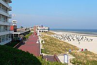
View of the beach promenade

Main beach with beach chairs

Aerial view from the east
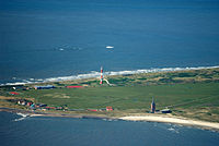
West of the island with new lighthouse, new west tower and youth hostel

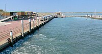
West pier Wangerooge


leisure offers

The range of leisure activities is largely determined by nature. Beach chairs can be rented at the level of the island village on the kilometer-long sandy beach . Guided mudflat hikes are offered. As early as the 1960s, various spa facilities were built, such as the Kurgastes house, the Kurmittelhaus and the Little Kurgasts house. A seawater indoor pool has been part of the tourist infrastructure since 1984 . The village square and the rose garden in the town center are well-tended parks . The National Park House is also located there as a local information and education center on the subject of nature conservation. You can get a good overview from the old lighthouse, which also houses the island museum. The leisure facilities include a tennis court , a tennis and squash hall , a surfing school , a sports field and a golf course . A riding stable offers horse rides in the dunes and on the beach. Boat trips to the neighboring islands and the seal banks are possible from the port . There is also a cinema on the island.
There are several youth, children's and country school homes as well as mother-child sanatoriums on the island . In 2009, a beach club with a discotheque was set up in the former school camp of the Oldenburg youth recreation centre .
particularities

A special feature of the island village is the Café Pudding . Centrally located, it is considered one of the symbols of the island. It is located on a round dune hill on the beach promenade. A beacon was placed on the dune in 1855 as a navigation mark. During the Second World War, the hill was expanded into a bunker. After the war it was demilitarized by order of the occupying power and found use as a café.
traffic
car freedom

Wangerooge is car-free , exceptions are emergency vehicles of the voluntary fire brigade , the rescue service and the German Society for the Rescue of Shipwrecked Persons as well as construction machinery. Other vehicles include electric carts for commercial transport and two large-capacity taxis as electric vehicles . Until the year 2000, horse-drawn carriages were used for commercial transport of loads. There are now carriage rides for guests again, especially at weddings. The tourists arriving at the island train station often bring their luggage to their accommodation in handcarts belonging to the landlords. Bicycles can be rented on the island or brought on the ship. The network of paths and cycle paths is well developed, with the exception of the extreme Ostend.
ship
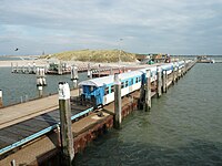
DB Fernverkehr ferry services are handled via the western pier in the south-west of the island . Several ferries operate daily, the timetable of which depends on the ebb and flow of the tide. The jetty was built in 1912 for military reasons to transport heavy artillery cannons and is popularly known as the cannon bridge. A marina is now attached to it. Wangerooges mainland port is the Carolinensiel offshore Harlesiel. Most of the passenger and freight traffic to the island is handled via it.
Until 1958, Wangerooge had a tide -independent jetty at the east end , but it silted up and only wooden remnants remain today. In addition, until the late 1990s there was a heavily tide-dependent marina in the center of the island south of the Saline plot.
air
The island can be reached by visitors via the small airport Flugplatz Wangerooge to the east of Inseldorf, at the end of Charlottenstraße . The operator is Wangerooger Flughafen GmbH , which was founded in 1929. The official airport designation reads Verkehrslandeplatz Wangerooge . The airfield has two take-off and landing runways. The longer of the two runs has an asphalt surface and is 850 m long, the grass runway is 500 m long. The airport is served by aircraft from FLN Frisia-Luftverkehr every hour from Harle Airport, which is only a five-minute flight away . There is also a helipad . The airport is closed for lunch. Outside the opening times of the airfield (including at night), only aircraft in rescue operations may land there, for example the ADAC rescue helicopter Christoph 26 , which is stationed at the Sanderbusch hospital in Sande .
island railway
The Wangerooger Inselbahn is a narrow- gauge railway with a gauge of 1000 mm , which regularly carries passengers and freight on the ferry connection from Harlesiel to Wangerooge, the approximately three-kilometer route from the harbor (western pier) to the centrally located village station. A branch line to West station is served if required. Between 1905 and 1958 the route led beyond the village station to the tide-independent ship landing stage Ostanleger . Since the ferries run at different times almost every day due to the tide dependency , the traffic times of the island railway are also different every day. There is an annual timetable from which the journeys for each day can be taken.
The railway operator is DB Fernverkehr , a subsidiary of DB AG . This makes the Wangerooger Inselbahn the only narrow-gauge railway operated by Deutsche Bahn.
impressions
west pier
Remains of the former east pier

Airport building with tower
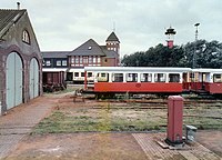
Train station with engine shed , 1984
The island railway at the western pier


care
Drinking water
The island has been supplied with drinking water by pipelines from the mainland since 1963 . For emergency supplies, there is a waterworks on the island with three wells about ten meters deep. The system, which was put into operation in 1951, also works as a storage pumping station with a storage volume of 2000 m³. The water pumping is possible because under Wangerooge there is a lens of fresh water that is curved like a watch glass up to a depth of 50 m. The reservoir was formed by the infiltration of rainwater. Such freshwater lenses can also be found on the other East Frisian islands, some of which produce drinking water for self-sufficiency.
waste water treatment
Wangerooge has had a sewage sludge humification plant for waste water treatment since mid-2005 . The suspended solids from the island's waste water are collected in a basin planted with reeds . The clarified water is pumped into the mud flats . When the basin is full after a few years, the humus soil is dredged and used.
Rescue station of the DGzRS

The German Society for the Rescue of Shipwrecked Persons (DGzRS) keeps a sea rescue boat in the island's ferry port , which is manned by volunteers from the island when the alarm is raised. The station has an all-terrain vehicle so that it can quickly get from the site to the distant port in the event of an emergency. A rescue shed for the helpers is located directly behind the DGzRS feeder.
Culture
language
Until around 1930, Wangerooger Frisian , a dialect of the East Frisian language , was spoken on the island . Alongside Saterland Frisian , which is still alive today, it was the only East Frisian dialect that survived into the 20th century. The storm surge catastrophe of the winter of 1854/1855 was not just the proverbial downfall for the Wangeroogische. Due to the relocation of the population to the mainland, the language community was torn apart and the language was no longer viable in the long term. After the dialect died out on Wangerooge, some speakers lived on the mainland until the 1950s.
island museum

Wangerooge has an island museum that has been based in the old lighthouse in the town center since 1980. The museum shows exhibits on the island's history, the emergence of spa tourism and an amber collection . A narrow-gauge tank locomotive built in 1929 for the Wangerooger Inselbahn and the former Wangerooger lifeboat Gesina (1971–1981) of the DGzRS are on display in front of the tower .
Regular events
In addition to the harbor festival, the following sporting events take place on the island throughout the year:
- Beach Volleyball Tournament
- West Tower Run as a fun run
- Skate -Night on the airport runway
- West Tower Cup as a sailing regatta
- Tennis Tournament
- Scalemates Meeting
education

Wangerooge has an island school for grades 1-10, in which since August 13, 2012 the school types primary , special needs , main (including the 10th grade) and junior high school as well as the secondary level I of the grammar school have been combined. The number of pupils is around 60, the number of teachers around 15. The lessons take place across classes and school types. The school in the island village is located in a building complex that served as barracks until the end of World War II , which was called Jade Barracks.
Pupils from the island who want to take their Abitur attend the Lower Saxony boarding school in Esens after the tenth grade . Over 90% of the students at the boarding school come from the East Frisian Islands.
sights and buildings
churches


There are two church buildings on Wangerooge: the Protestant parish church of St. Nikolai and the Catholic parish church of St. Willehad . The latter is particularly popular with the numerous tourists during Easter and the summer holidays.
- St. Nikolai: The evangelical church building has stood right next to the old lighthouse since 1910. Before the reconstruction, a chapel built in 1866 stood on this site. The church of the western village of the island, which was destroyed in 1586, was also called St. Nicolai. The naming can be traced back to Saint Nicholas , who is the patron saint of seafarers and merchants. In the Middle Ages he was especially revered in the northern German coastal region, and many churches bear his name. The importance of the patron saint can be seen from the fact that before 1800 on Wangerooge, St. Nicholas Day was a higher public holiday than Christmas .
- St. Willehad: The new Catholic church building on the island, which has existed since 1963, is named after Willehad , the missionary bishop of the Frisians . The previous church, built in 1901 on Schulstraße, was destroyed on April 25, 1945, together with the neighboring Willehad monastery, during the Allied air raid on Wangerooge . The Catholic parish of St. Willhad von Wangerooge is ecclesiastically administered by the diocese of Münster . Its pastor was Kurt Weigel until 2015 . His successor, Egbert Schlotmann, together with his vacation pastoral team, offers a wide-ranging program for tourists and locals.
- The New Apostolic Church is represented on Wangerooge with a small congregation in the Freesenhus , which is looked after by the Elders' District in Wilhelmshaven .
cemeteries and memorials

West of the island village in the dune area is a cemetery with a cemetery chapel. In 1951, the German War Graves Commission (VDK) established a cemetery of honor for the victims of the 1945 air raid, where 238 victims were reburied . In the dunes east of the lookout dune there is a bunker that has been declared a war grave . The command bunker, occupied by 20 people, received a direct hit during the air raid. Since it only contained body parts, it was closed. Today, an inscription plaque and a large cross commemorate the event.
(Light) towers

Wangerooge has an active sea light ( New Lighthouse Wangerooge ) and two historic sea marks , the old lighthouse in town and the west tower. Numerous other lighthouses and navigation marks can be seen from the island, which serve as a guidance system for seagoing vessels entering and exiting the waters of the Jade , Weser and Elbe (Weser radar chain). Navaids, which can only be seen in their entirety with the naked eye from Wangerooge, include the well-known Roter Sand lighthouse and its successor Alte Weser , as well as the Helgoland , Minsener Oog and Mellumplate beacons .
Old Lighthouse
The old lighthouse in the center of Wangerooge was completed in 1856 and was at the east end of the island at that time. Initially powered by a petroleum fire, it became electrically powered towards the end of the century and increased to 39 meters in 1927. Since the lighthouse was replaced by the New Lighthouse in 1969 , it has served as a lookout point. Since 1980 the island museum has been set up in it. Since March 15, 1996, one of the most unusual registry offices in Germany has been located at the top of the tower . It was the first lighthouse in Germany where you could get married. By 2012, around 5,000 couples had gotten married at the lighthouse .
New Lighthouse

With the expansion of the Jade Fairway and the associated increase in shipping traffic, it became necessary to build a new lighthouse. He should provide more security in this busy area of the German Bight . The old lighthouse proved to be no longer suitable because of its low height and its unfavorable location in the island village. Since 1969, the new tower, built behind the dunes on the west of the island, has guided passing ships. The wildfire at a height of 61.22 meters is one of the highest on Germany's coasts and has a range of 56 kilometers. According to the Wilhelmshaven Water and Shipping Authority, the tower would be 67.2 meters taller than the Campen lighthouse , making it the tallest lighthouse in Germany. The identifier is the signal: 0.1 second flash (red), 4.9 second pause.
Marine signal station
At the western end of the beach promenade is the 35 meter high tower of the former naval signal station, which was used to transmit messages to passing ships. Built in 1876 as a coastal observation hut, the tower has been rebuilt and expanded several times. As early as 1968 it was decommissioned as a naval signaling station of the German Navy, but served as a directional radio station for the Navy until the 1990s. The long use underscores the strategic importance that the island held for the military due to its location in the North Sea.
west towers

In the course of the island's history, a total of three (west) towers were built, of which only the last tower from 1932 remains today. The towers each had a different function.
The first west tower, probably erected in the 14th century, was the church tower of the Nikolai Church in Inseldorf, which served as a landmark for ships to orient themselves. When the sea came closer as a result of the eastward shift of the island, the village with church and cemetery had to be given up.
The second west tower was inaugurated in 1602 after five years of construction. With the construction of the tower, the desire of Bremen merchants for a landmark for their ships entering the Weser was also met. In the pointed roof of the tower there was a lantern room with 48 windows, in which the beacon was initially operated with vegetable oil. The tower was a 50-meter-tall, multi-purpose structure and served as a church , storm surge shelter, prison, ice house , and flotsam storage over five floors . Around 1900, the already damaged tower was far in the water and was blown up at the end of 1914, ostensibly for military reasons.
A few years after the tower was blown up in 1914, the idea of building a tower for young people came up. In 1932, the New West Tower was rebuilt at a different location (about 900 meters south) based on the model of the previous tower. It was created during a voluntary work assignment by the Oldenburg Gymnastics Federation . The brick building is 56 meters high and has eight floors. When it was completed at Whitsun 1933, the new rulers immediately took over the tower and used it as a hostel for the Hitler Youth . After the Second World War, the tower became a youth hostel for the DJH , with a spacious new youth hostel building being built next to the tower in 2005.
West Tower as a trigonometric point

The 50 meter high western tower from 1602 rendered valuable services in the national survey in the 18th and 19th centuries due to its height . A trigonometric point was attached to the tower. In conjunction with other prominent points on Neuwerk and in Jever , measurements could be carried out using triangulation . This surveying method, which was still new at the time, was first used on Wangerooge in the Oldenburg land survey around 1780. During the surveying of the Kingdom of Hanover by Gauss' land survey in 1825, the geodesist Carl Friedrich Gauss stayed at Wangerooge for measurements. The tower, which had already been damaged, was used for another survey in 1882 at the Prussian state survey .
In memory of his surveying work, Gauss was depicted on the fourth series of DM 10 notes. Among other things, the survey point Wangeroog is shown on the back (can be seen as an island in the top left of the network diagram). The illustration appeared on around 300 million banknotes from 1989 to 2001.
personalities
Born on Wangerooge
- Carlo Regensdorff (1792–1879), merchant and co-founder of Austrian Lloyd
- Karl Alfred Wolken (1929–2020), writer
- Harro Maass (born 1939), illustrator and painter
Connected to Wangerooge
- Lorenz Oken (1779-1851), German doctor, natural scientist and natural philosopher, was on Wangerooge from November 1806 to April 1807 as a land physician and for marine biological studies.
- Heinrich Heine (1797–1856) fled from Norderney to Wangerooge for a short time in 1827 for political reasons
- Hans Severus Ziegler (1893–1978), Nazi functionary, publicist, teacher at the Inselgymnasium for a long time
- Kurt Weigel (* 1950), priest, holiday pastor and author, lived on Wangerooge from 1980 to 1985 and from 1994 to 2015
- Gisela Karschuck , photo model, Miss Germany 1962, lives on Wangerooge
Wangerooge in literature
- Regine Kölpin : Grandma becomes Grandma . Droemer Knaur, Munich 2018, ISBN 978-3-426-52120-5 .
- Klaus-Peter Wolf : Dead silence in the Watt . Fischer Paperback, Frankfurt 2017, ISBN 978-3-596-29764-1 .
- Wolfgang Bellmer: Greetings from Olga . Reprint-Verlag, Leipzig 2009, ISBN 978-3-8262-0240-7 .
- Gertrud Zelinsky : Peach Skin and Autumn Crocus. Novel of a Late Love . Verlag Günther Emig , Niederstetten 2007, ISBN 978-3-00-020819-5 (plays on Wangerooge).
- Karl Alfred Clouds : The Schnaps Island . German publishing house, Stuttgart 1961.
- John Pearson: In the James Bond book that accompanies the films. The Authorized Biography , the fictional character James Bond was in Wangerooge at the beginning of the Second World War as a member of the Royal Navy . Detached from a submarine and buried in the sand, he was supposed to observe a submarine bunker , which never actually existed on Wangerooge.
literature
- Georg Sello : Östringen and Rüstringen. Ad. Littman, Oldenburg 1928.
- BE Siebs : The Wangerooger. Littmann, Oldenburg 1928. (unchanged reprint. Verlag Schuster, Leer 1974, ISBN 3-7963-0038-3 )
- Wolfgang Hartung (ed.): Wangerooge as it was, was and is. New edit. Diekmann, Oldenburg 1951.
- Friedrich-Wilhelm Jürgens: History of the North Sea health resort Wangerooge 1804-1954. CL Mettcker & Sons, Jever 1954.
- Hans-Jürgen Jürgens: Testimonies from an ominous time. A war diary about the events of 1939-1945 in the Wangerooge-Spiekeroog-Langeoog area and the situation in the Reich and on the fronts. CL Mettcker & Sons, Jever 1989. (6th edition. 2003, ISBN 3-87542-008-X )
- Hans-Jürgen Jürgens: Wangerooger Chronicle . (2010, 2012, 2013).
- Wangerooge - Illustrated Travel Guide . Edition Temmen, Bremen 2003, ISBN 3-86108-422-8 .
- Albrecht Eckhardt, Heinrich Schmidt (ed.): History of the State of Oldenburg. 3rd Edition. Holzberg, Oldenburg 1998, ISBN 3-87358-285-6 .
- Hans Patze , Ernst Schubert (ed.): History of Lower Saxony . 3 volumes. Lax, Hildesheim, (last volume 3, part 1: 1998, ISBN 3-7752-5901-5 )
- Isolde Wrazidlo: On the way to Wangerooge, natural history island guide . Satzwerk-Verlag, Goettingen 1997, ISBN 3-930333-19-8 .
- E. Oldewurtel: Greetings from Wangerooge . Frisia Verlag, Staufenberg 1981, ISBN 3-88111-048-8 .
- Wangerooge (short guide, overview map) (= compass hiking map, 733). 2003, ISBN 3-85491-151-3 .
- Peter Sievert: The island of Wangerooge according to its former and present state . Hanover 1982. (according to the island pastor Theodor Schmedes, Wangerooge, 1874)
- Ernst Andreas Friedrich : The west tower of Wangerooge. In: If Stones Could Talk. Volume I. Landbuch-Verlag, Hanover 1989, ISBN 3-7842-0397-3 , pp. 186-188.
- Martin Stolzenau: Seetzen saw Wangerooge as a spa . In: Heimat am Meer , supplement to the Wilhelmshaven newspaper , no. 17/2021, from August 14, 2021, p. 67 f.
web links
- Wangerooge.de – official website of the municipality of Wangerooge
- Wangerooge information on nordwestreisemagazin.de
- virtual wangerooge – comprehensive website about the island
itemizations
- ↑ State Office for Statistics Lower Saxony, LSN-Online regional database, table A100001G: update of the population, as of December 31, 2020 ( help on this ).
- ↑ Object information on WMS levels. In: GDI-NI. Landesbetrieb Landesvermessung and Geobasisinformation Niedersachsen, retrieved on September 30, 2019 . , Note on the query: Activate the "Administrative boundaries and locations → Municipal boundaries" layer. Query via tool info (toolbar above) and click on the outline of the island of Minsener Oog.
- ↑ According to information from the Lower Saxony State Office for Water Management, Coastal Defense and Nature Conservation (NLWKN)
- ↑ NLS-Online Table Z0010001 Floor area by type of planned use . Lower Saxony State Office for Statistics and Communications Technology (LSKN), January 1, 2005, retrieved April 23, 2009 .
- ↑ Melanie Hanz: Census 2011 Friesland: Friesland loses 1300 citizens through statistics. In: Northwest newspaper. 1 June 2013, retrieved 30 September 2019 .
- ↑ Census Database - 2011 Census Results. Retrieved 15 July 2019 .
- ↑ Both figures are given in the media. In the census database, the value is given as 1311. See: https://results.zensus2011.de/#StaticContent:034550021021,ROOT,ROOT ,
- ↑ All politically independent municipalities in Germany by population on December 31, 2011 based on the 2011 census and earlier censuses. In: Municipal directory special publication, territorial status: December 31, 2011. Federal Statistical Office, May 2013, retrieved on September 30, 2019 .
- ↑ National Park House Wangerooge. Lower Saxony Wadden Sea National Park, 2010, retrieved September 30, 2019 .
- ↑ Information stations of the national park. In: mellumrat.de. The Mellumrat e. V., accessed September 30, 2019 .
- ↑ Carsten Heinecke: Butterflies of the East Frisian Islands - A guide for explorers . In: National Park Administration "Lower Saxony Wadden Sea" (ed.): Series of publications National Park Lower Saxony Wadden Sea . 1st edition. tape 14 , 2015, ISBN 978-3-00-049104-7 , p. 196 .
- ↑ Arend Remmers : From Aaltukerei to Zwischenmooren. The settlement names between Dollart and Jade . Verlag Schuster, Leer 2004, ISBN 3-7963-0359-5 , p. 232.
- ↑ Entry by Stefan Eismann on Wangerooge in the scientific database " EBIDAT " of the European Castle Institute, retrieved on December 5, 2018.
- ↑ Marion Ikemeyer: The dune vegetation of the island of Wangerooge. Hamburg 1986, p. 4.
- ↑ The Frisian language in Neu-Wangerooge was developed after 1920 by Prof. Dr. Otto Bremer, Halle, recorded with a phonograph. Source: Oldenburger leaves for local history and homeland security. No. 1 of January 10, 1927, special supplement, "In memory ..." by Georg Janssen, Sillenstede.
- ↑ Erik Kohl: The New Year's storm tide 1854/'55. In: virtual wangerooge. Retrieved September 30, 2019 .
- ↑ rene Altenmüller: When the flood tore Wangerooge. In: NDR.de - culture - history - chronology. 30 November 2011, retrieved 30 September 2019 .
- ↑ Erik Kohl: Storm surge 1962 in the protocol. In: virtual wangerooge. Retrieved September 30, 2019 .
- ↑ Shallows threaten port off Wangerooge - help uncertain. In: welt.de. April 22, 2008, retrieved September 30, 2019 .
- ↑ Lower Saxony Municipal Constitution Act (NKomVG) Section 46 – Number of MPs. 17 December 2010, retrieved 30 September 2019 .
- ↑ a b Election of the municipal council September 12th, 2021 - North Sea health resort Wangerooge
- ↑ Local elections 2021: Voter turnout higher than five years ago. September 13, 2021, retrieved September 13, 2021 .
- ↑ Election of the mayor 2018 Friesland - overview. Retrieved July 22, 2018 .
- ↑ Wangerooges Mayor Lindner died. In: Jeversche Wochenblatt . January 23, 2018, retrieved January 23, 2018 .
- ↑ Olaf Lies: About me. Retrieved September 30, 2019 .
- ↑ Bundestagswahlkreis 26. The Federal Returning Officer, retrieved on November 16, 2018 .
- ↑ Ostfriesland: Further candidates make the leap to Berlin via state lists. Retrieved September 28, 2021 .
- ↑ a b Main statutes of the municipality of North Sea Health Resort Wangerooge. (PDF; 47 kB), accessed 7 September 2013.
- ↑ Wangerooger Inselbote. No. 7/1973.
- ↑ a b Heie Focken Erchinger, Martin Stromann: Storm surges - coastal and island protection between Ems and Jade . 1st edition. Verlag Soltau-Kurier, North 2004, ISBN 978-3-928327-82-4 , p. 163 .
- ↑ Wangerooge - An illustrated travel guide. Edition Temmen, Bremen 2003, p. 85.
- ^ Wangerooge. In: die-nordsee.de. Die Nordsee GmbH, retrieved 30 September 2019 .
- ↑ Jürgen Peters: Bunkers and ice bombs in the Wangerooger "Café Pudding". In: Wilhelmshaven Newspaper. 29 April 2013, retrieved 30 September 2019 .
- ↑ The "Pudding" - a moving story. Retrieved September 30, 2019 .
- ↑ North Sea Health Resort Wangerooge - island in the southern North Sea. Schöning-Verlag, Lübeck 2006, p. 6.
- ↑ Waterworks and storage pumping stations. Oldenburgisch-Ostfriesischer Wasserverband (OOWV), retrieved 16 November 2018 .
- ↑ Groundwater abstraction on the islands. In: nationalpark-wattenmeer.de. Retrieved September 30, 2019 .
- ↑ a b Wangerooge Island School. Retrieved September 30, 2019 .
- ↑ Annual report on the Inselschule 2013. (PDF; 6,071.04 kB) p. 8 , retrieved on September 30, 2019 .
- ↑ Annual report on the Inselschule 2013. (PDF; 6,071.04 kB) p. 3 , retrieved on September 30, 2019 .
- ↑ Wangerooger Inselbote. No. 11/1994.
- ↑ Insel pastor Egbert Schlotmann about the turning point in the West. Interpretation of the readings of Easter Sunday (B). In: Church+Life Network. March 31, 2018, retrieved September 30, 2019 .
- ↑ Wangerooge lighthouse. Wasser- und Schifffahrtsamt Weser-Jade-Nordsee, retrieved September 30, 2019 .
- ↑ Wangerooge - An illustrated travel guide. Edition Temmen, Bremen 2003, p. 81.
- ↑ Hajo Bernett : The reconstruction of the west tower of Wangerooge in the mirror of contemporary history. In: Wolfgang Buss , Arnd Krüger (eds.): History of sports: maintaining traditions and changing values. Festschrift for Wilhelm Henze . NISH, Duderstadt 1985, ISBN 3-923453-03-5 , pp. 161–174.
- ↑ G. Waldo Dunnington: Carl Friedrich Gauss – Titan of science . The Mathematical Association of America, Washington, DC 2004, ISBN 978-0-88385-547-8 , pp. 133 .
- ↑ John Pearson: Agent 007. The Life of James Bond. A fictitious biography . Edition Sven Erik Bergh (in Ingse Verlag), Zug (Switzerland) 1974, ISBN 3-430-17407-4 (Translated from English by Eva Korhammer.).
Borkum | Ban | Lütje Hörn | Brauerplate | tile plate | Memmert | Juist | Norderney | Baltrum | Langeoog | Spiekeroog | Wangerooge | Minsen Oog | Mellum
buckhorn | Jever | Sands | Schortens | Varel | Wangerland | Wangerooge | note
| west of it | East Frisian Islands | east of it |
| Spiekeroog | Wangerooge | Minsener Oog |