East pier Wangerooge
The east pier Wangerooge was a ship pier on the East Frisian island of Wangerooge .
In 1903, the east pier was built as the second pier next to the west pier Wangerooge and connected to the station in the island village by a 5.4 kilometer rail link from the Inselbahn . The pier was built and financed by Norddeutscher Lloyd , which served the island with large ships from Wilhelmshaven and Bremerhaven . In contrast to the jetty on the west side of the island, it could be approached regardless of the tide due to its location on the sea channel of the Blue Balje .
After the Second World War , the number of passengers reached record highs, as the excursion island Helgoland was still under British occupation and could not be called at. Only after 1952 did Helgoland become accessible to Germans again. Holidaymakers from the direction of Wilhelmshaven now preferred Heligoland, the shipping traffic at the east pier of Wangerooge fell sharply.
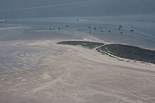
On the east side of Wangerooge, as on the other East Frisian islands, a lot of sand is deposited, so that the east jetty could not be approached due to silting. Since the excursion traffic from Wilhelmshaven and Bremerhaven has meanwhile returned to Helgoland, the necessary dredging at the east pier was no longer worthwhile. From 1955 the east line was a deficit business and represented a competition to the west line. As a result of low occupancy, the pier was left to its own devices in 1958, the track connection to the village was dismantled.
During the time that the east pier existed, it was often damaged by storm surges in winter and had to be repaired again and again.
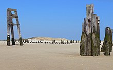
Today there isn't much left of the east pier. There are still some wooden posts that are used to moor sports boats.
literature
- Silke Arends: Ostanleger in: Travel Guide East Frisian Islands , Hamburg, 2016 ( online )
Web links
- Photo of a train arrival at the east pier around 1935
- Photos and text on the disused island railway to the east pier
Coordinates: 53 ° 46 ′ 28.2 ″ N , 7 ° 58 ′ 18 ″ E


